


Summary
Foveaux Strait, (Māori: Te Ara-a-Kiwa, lit. 'the Path of Kiwa') is a strait that separates Stewart Island from the South Island of New Zealand. The width of the strait ranges from about 23 to 53 km (14 to 33 mi) and it has an area of approximately 2,460 square kilometres (950 sq mi). The depth of the strait ranges between 18 and 46 m (59 and 151 ft). The strait has been described as "one of the roughest and most unpredictable stretches of water in the world". Severe weather and sea conditions in the strait have contributed to multiple shipwrecks and fatalities.
| Foveaux Strait | |
|---|---|
| Māori: Te Ara-a-Kiwa | |
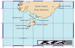 | |
 Foveaux Strait Foveaux Strait separates the South and Stewart Island islands of New Zealand.  Foveaux Strait Foveaux Strait (Oceania) | |
| Coordinates | 46°40′S 168°11′E / 46.67°S 168.18°E |
| Surface area | 2,460 square kilometres (950 sq mi) |
The sea floor in the strait is mostly flat with patches of coarse pebble and an upfault of bedrock close to sea level, near Te Waewae Bay. Captain James Cook may have sighted the strait during his circumnavigation of the South Island in March 1770 on the HMS Endeavour. It was not properly recorded until 1804 when an American sealer Owen Folger Smith made a chart. The western entrance of the strait, commonly referred to as the "The Solanders" was dominated by American whaleships in the nineteenth century, and was described as "the world's prime sperm whale fishing ground". Ferry services began in 1877 and still operate regularly between Oban and Bluff Harbour The journey is about 39 km (24 mi) and typically takes an hour to complete.
Major landforms on the northern coast of the strait include three large bays, Te Waewae Bay, Oreti Beach, Toetoes Bay and Bluff Harbour. There are a large number of small islands in the strait, including Ruapuke Island and the northern Tītī / Muttonbird Islands. Foveaux Strait is known as the main fishing grounds for the economically important Bluff oyster industry. The area of the strait is known for marine life including seals and sea lions, and a large variety of seabirds, most notably the endemic Foveaux shags and the rare yellow-eyed penguins.
Scope edit
Foveaux Strait is a seaway separating Stewart Island (Rakiura) from the South Island (Te Wai Pounamu) in New Zealand. The width of the strait ranges from about 23 to 53 km (14 to 33 mi). There is no formal definition of the eastern and western boundaries of the strait — different sources set the eastern boundary of the strait at Waipapa Point, or alternatively further east at Waikawa Harbour. The western boundary has been defined as a line at 167° 43'E, or further west at Sand Hill Point. Depending on the definition of eastern and western boundaries, the area of the strait is approximately 2,460 km2 (950 sq mi).[1][2] There are a large number of small islands in the strait, including Raratoka Island, Dog Island, the Muttonbird Islands and Ruapuke Island. The Solander Islands lie to the west and outside of the area usually defined as Foveaux Strait.
Toponymy edit
The Māori name for the strait is Te Ara a Kiwa, meaning the pathway of Kiwa. A less common alternative is Te Ara a Kewa.[3][4][5] There are numerous stories in Māori mythology about the origin of the names. In one account, Kiwa became exhausted from crossing the isthmus which conected Southland (Murihiku) and Stewart Island (Rakiura). He asked the whale Kewa to chew through the isthmus to create a waterway, so he could travel to Rakiura using a waka.[6][7][8]
The strait was first properly charted by an American sealer Owen Folger Smith who had been in Sydney Harbour with Eber Bunker from whom he probably learned of the eastern seal fishery.[9] Smith charted the strait from the whaleboat of the sealing brig Union (out of New York) in 1804 and on his 1806 chart he named it Smith's Straits.[10][11] This chart was given to Governor of New South Wales, Philip Gidley King, who did not make it public, even though he was duty bound to communicate all hydrographic discoveries to the Admiralty.[12] Later in 1806, another American vessel, the Favorite collected large amounts of sealskin from the area before continuing its journey to Sydney through the strait, leading to the passage being referred to as "Favorite's Strait" by some early maps and American logbooks.[10][13]
Captain John Grono named the strait Foveaux Strait in March 1809 after his friend Joseph Foveaux,[13] Lieutenant-Governor of New South Wales.[14][15] His vessel Governor Bligh struck a rock in the strait, but suffered little damage. He described the strait as being about 36 to 40 miles (58 to 64 km) in width, with very dangerous navigation from the numerous rocks, shoals and little islands, with which it is crowded. The sealing brig Pegasus, commanded by Eber Bunker, ran aground in the strait in 1809, and in the report on the grounding in The Sydney Gazette, the strait was called Foveaux Strait.[16]
In 1824, Captain Kent attempted to rename the strait to "Tees Strait", but was unsuccessful.[17] A more recent proposal in 1968, for the strait to be renamed to "Kupe Strait" was also unsuccessful.[18][19]
History edit


Māori settlement edit
In Māori oral tradition, their history in the Southland region is traced to the arrival of two chiefs Rākaihautū and Tamatea. Rākaihautū is a tīpuna (ancestor) of the Waitaha people, and was the captain of the Uruao waka (canoe). The waka Tākitimu, captained by Tamatea, was wrecked near Te Waewae Bay on the shores of what is now called Foveaux Strait. In the traditional account, the Tākitimu Mountains in Southland are the overturned hull of the canoe. The name given to the lower parts of the South Island was Murihiku, a name that is loosely translated as ‘the tail end’ of the land.[20]
Murihiku Māori who settled around Foveaux Strait were mostly hunter-gatherers, who moved between the inland areas and the coast, including the shores and islands of the strait. They established permanent settlements on Ruapuke Island in Foveaux Strait, and on the South Island coastline at Aparima (Riverton), Awarua (Bluff) and Waikawa. The ocean provided food year round, and tītī (mutton birds) were taken from islands off Rakiura. Groups would move inland to fish and catch eels in the rivers between late winter and into summer. In the autumn, they hunted forest birds including weka, takahē, kererū, kākāpō and kākā.[21]
In its early days; 350 Māori spread between the modern-day settlement of Bluff and Ruapuke Island. Stewart Island had about 85 Māori, primarly occupying Horseshoe Bay and an area referred to as Te Wehi-a-Te-Wera, a narrow peninsula of the entrance of Paterson Inlet.[22][23]
In the early 19th century. Hone Kai, a Māori chief in the Foveaux Strait region, declared Codfish Island (Whenua Hou) as the place where Ngāi Tahu women and sealers could stay under protection, accordingly making it one of New Zealand's first multiracial communities.[24][25]
Cook's passage around Stewart Island edit
In March 1770, Captain James Cook, a British explorer, circumnavigated the South Island on the HMS Endeavour during his first voyage to New Zealand. He passed around the southern tip of Stewart Island during this voyage, and sighted the area of Foveaux Strait, but did not record the presence of a passage.[10] Some suggest that he did discover the strait, but hid this discovery for reasons of military and colonial policy.[26] It is also possible that Cook genuinely made an error, as his focus was on finding the southern extent of New Zealand, and conditions were unfavourable for more closely exploring the possible strait.[10][27]
Sealing edit
Māori living around Foveaux Strait hunted seals for food, and used seal skin for clothing and seal teeth for fishing hooks. The first Europeans known to have hunted seals in Southland were the crew of James Cook's vessel the HMS Resolution, during her stay in Dusky Sound in 1773. An Australian-based commercial sealing gang was dropped off in Dusky Sound in 1792 to gather seal skins. However, new opportunities for sealing in Bass Strait made New Zealand less attractive, and there was little further seal hunting by Europeans until renewed activity at Dusky Sound in 1803. Between 1805 and 1808, there were large scale seal hunting campaigns in the Antipodes Islands, Bounty Island and the Auckland Islands. From around 1808, sealing took place around around Foveaux Strait. In one voyage to the strait from their base at Port Jackson (Sydney) in September 1808, the Governor Bligh, captained by John Grono, returned with 10,000 skins.[28] Some sealing gangs spent months or years in the region and there was increased contact and trade between sealers and Māori living in the area. One sealing gang was dropped off from the brig Fox, on Solander Island. They were left there for over four years until being picked up by the Perserverance in 1813.[29] A few sealers took up living with Māori, and some earned high ranking through marriage to the daughters of chiefs. From around 1810, the seal colonies around Foveaux Strait were so depleted that large scale commercial sealing was no longer economically viable.[30][31]
Whaling edit
Over the 40 year period 1844–1885, there were at least 187 separate visits by whaling ships to Foveaux Strait, with a peak from 1856–62. An estimated 600 sperm whales were killed.[32] Numerous shore-based whaling stations operated along the coastline of the strait.[33][34] The western entrance of the Foveaux Strait (near the Solander Islands) was formerly described as "one of the world's prime sperm whale fishing ground".[35] In February 1875, the American barque Chance left Bluff Harbour, and spent months whaling primarily in the Solanders. She arrived back to Bluff on 21 May with 360 barrels of whale oil.[36]
Geography edit
Major landforms on the northern coast of the strait include three large bays, Te Waewae Bay, Oreti Beach, Toetoes Bay and Bluff Harbour. There are a large number of small islands in the strait, including Ruapuke Island and the northern Tītī / Muttonbird Islands.
During the Last Glacial Period when sea levels were at least 100 m (330 ft) lower than current levels, the South Island and Stewart Island were connected by a coastal plain.[37][38] This claim is also supported by the gravel patterns in the strait, which are distinguishable by petrographis analyses of the pebbles, that confirm the existence of dryland.[39] After sea levels began to rise 7,000 years ago, Foveaux Strait was created between the two islands.[38] The sea floor in the strait slopes towards the west, increasing in depth from around 18 to 46 m (59 to 151 ft).[40][41] The sea floor is mostly flat with patches of coarse pebble and an upfault of bedrock close to sea level, near Te Waewae Bay. Small amounts of Stiracolpus symmetricus shells and fine sands lie nearby, which occur of the mouths of some rivers,[42] salinities in the strait is constantly low, particularly near the river mouths of the southern coastline of the Southland, such as the Waiau River.[43]
The climate of the Foveaux Strait region is severe by New Zealand standards with daily average temperatures of around 14 °C in summer, and 5.3 °C in winter. The annual average rainfall is more than 1,100 millimetres (43 in) and there are around 100 windy days per year. Gale force winds are common in Foveaux Strait, with a frequency that is second only to Cook Strait.[44]
The sea conditions and tidal currents in Foveaux Strait are influenced by the sub-tropical convergence zone (STCZ) a frontal zone between subantarctic waters to the south, and subtropical waters to the north. The southern boundary of the STCZ lies at around 46 °S, and runs eastwards from Tasmania, giving rise to the Southland Current that flows from the continental shelf west of Stewart Island, through Foveaux Strait and then north along the coast of the South Island. The waters of the Southland Current are a mixture of sub-tropical water and some sub-antarctic waters from the Australasian region, and it has a major influence on ocean conditions in Foveaux Strait and the south-east coast of the South Island.[45][46]
Sea conditions edit
Foveaux Strait has been described as "one of the roughest and most unpredictable stretches of water in the world".[47] Strong westerly winds regularly blow through the strait of upto 130 km (81 mi) an hour, frequently creating swells with an average height of over 3 m (9.8 ft) and occasionally over 10 m (33 ft).[48][49] The tidal stream in the strait can flow at speeds of 80 cm (31 in) per second and up to 120 cm (47 in) per second during spring tides.[50] In 1850 the survey vessel HMS Acheron was caught in a gale in Foveaux Strait that lasted for five days. The vessel took shelter at Ruapuke Island, but Captain John Lort Stokes reported: "All this time the sea resembled a huge boiling cauldron, hissing and roaring, whilst its break over the numerous reefs by which the vessel was encompassed had an appearance awfully impressive when seen in the gloom of approaching night".[51] Many whaling ships used Port William on the northwest coast of Steward Island as shelter when there was strong westerlies or severe sea conditions in Foveaux Strait.[52][53]
The French navigator Jules de Blosseville on board a French expeditionary vessel Coquille, was the first person to describe the strait in detail. He wrote in 1823: "Whirlpools are frequently to be met with and the position is one of great peril when the direction of the waves is contrary to that of the wind".[54] He also compared Foveaux Strait with Bass Strait, writing that currents were "much stronger", the most dangerous between passage being between Raratoka Island (Centre Island) and the South Island, where tide the flow backs reaching speeds of up to 5–6 miles (8.0–9.7 kilometres).[55] The combination of wind, tides and seafloor topography in Foveaux Strait can lead to dangerous overfalls and tidal rips. In 2009, following several accident investigations, Maritime New Zealand arranged for warning notes to be added to charts of the area.[56]
Shipwrecks edit
There is a long history of shipwrecks and vessels capsizing in Foveau Strait. The worst incident was on 29 April 1881, when the SS Tararua struck Otara reef 13 km (8.1 mi) off Waipapa Point,[57][58][59] Of the ship's 151 passengers, only 20 survived. This incident led to the establishment of a lighthouse at the point.[60][61] Serious incidents with multiple fatalities have continued into the 21st century, and the Bluff Coastguard is often called upon to assist vessels in distress in Foveaux Strait.[62]
| Ship | Year | Location | Description | Fatalities | Reference(s) |
|---|---|---|---|---|---|
| Unknown | 1836 | Wreckage between Passage Islands and Toetoes Bay | Unknown ship of about 300 tons | Unknown | [63][64] |
| Laughing Water | 1870 | SW of Pahia Point | 411 ton wooden barque | 1 | [65][66] |
| Unknown | 1875 | off Orepuki | Whaleboat | 3 | [67] |
| Unknown | 1875 | off Orepuki | Whaleboat | 7 | [68] |
| The William Ackers | 1876 | Waipapa Point | Cargo Ship | 8 | [69][70][71] |
| SS Tararua | 1881 | Otara Reef 13 km (8.1 mi) offshore of Waipapa Point | Passenger steamer | 131 | [69][72][73] |
| Marie Ange | 1884 | Solander Island or Foveaux Strait | 275 ton iron barque | all | [74][75] |
| Champion | 1885 | mouth of Patterson Inlet | Cutter | 3 | [76] |
| Nellie | 1888 | 11 km (6.8 mi) offshore of Dog Island | Fishing schooner | 1 | [77] |
| Star of Erin | 1892 | Waipapa Point | Cargo Ship | nil | [78][79] |
| Philadelphia | 1898 | Wreckage at Orepuki | 1,710 ton steel full-rigged ship | all | [80] |
| Iris | 1913 | Between Ruapuke Island and Bluff | 4 ton auxiliary cutter | 4 | [81] |
| Mararoa | 1930 | Foveaux Strait | Fishing launch | 2 | [82] |
| Waikouaiti | 1939 | South-east corner of Dog Island | Cargo Ship | nil | [69][83] |
| Sea Mew | 1954 | Foveaux Strait | Fishing vessel | 1 | [84][85] |
| Reo Moana | 1959 | Foveaux Strait | 50-foot motor trawler | 3 | [86][87] |
| Aoteama | 1978 | Foveaux Strait | wooden fishing vessel | 2 | [88] |
| Unknown | 1984 | off Stirling Point | Dinghy | 2 | [89] |
| Cygnet | 1985 | Foveaux Strait | Fishing vessel | 3 | [88] |
| Rangi | 1987 | Foveaux Strait | Wooden fishing vessel | 2 | [88] |
| Linda Marie | 1988 | Foveaux Strait | Fishing vessel | 2 | [88] |
| Avenger | 1996 | Foveaux Strait | Fishing vessel | 2 | [90] |
| Unknown | 2001 | off Stirling Point | Dinghy | 1 | [91] |
| Kotuku | 2006 | near Womens Island | Fishing vessel | 6 | [92] |
| Unknown | 2010 | north of Dog Island | Dinghy | 1 | [93][94] |
| Extreme 1 | 2012 | off Ruapuke Island | Recreational fishing vessel | 2 | [95][96] |
| The Easy Rider | 2012 | Northern tip of Stewart Island | Fishing vessel | 8 | [97][98][99] |
| Torea | 2012 | Green Island, near Ruapuke Island | Fishing vessel | nil | [100][101] |
| Munetra | 2014 | Foveaux Strait | Yacht | 3 | [102][103] |
| Ayson | 2014 | off Stirling Point | Fishing vessel | nil | [104] |
Lighthouses edit

From the early days of European settlement it was clear that a lighthouse was needed in Foveaux Strait, but there were long discussions in the 1860s where to place it. Captains with local experience were asked for their opinion, and they suggested possible sites on Raratoka Island, Ruapuke Island, Stewart Island, Solander Islands, and Dog Island.[105] Captain Thomas Robertson visited Dog Island in 1863 and stated that the north-eastern edge of the island was an ideal place for a boat harbour, Robertson spoke with a local Māori chief, Tōpi Pātuki, assured Captain Robertson that there was a good water supply on the island.[106] Later, it was chosen as Southland's first site for a lighthouse; the recommendation was made by the Invercargill Harbour Master to James Menzies, the first Superintendent of the Southland Province.[107]
A lighthouse was also constructed on Raratoka Island (also known as Centre Island). In 1853, the island was purchased from the Māori owners. The lighthouse tower was built from kauri timber and is 12 m (39 ft) tall and started operations from 1878.[108][109] The most remote lighthouse in Southland is the Puysegur Point Lighthouse at the northwest point of the entrance to Foveaux Strait, overlooking the Tasman Sea.[110][111] Operation of the light at Puysegur Point began in 1879.[112] A further lighthouse at Waipapa Point was established in January 1884 after the sinking of SS Tararua. It is 13.4 m (44 ft) tall and was built from kauri and tōtara timber.[113]
Fauna edit
Seabirds edit

New Zealand has been described as the seabird capital of the world because of the large number of seabird species that breed on New Zealand territory, and the high diversity of species including albatross, penguins, petrels and shags.[114] Foveaux Strait is one of the key locations around New Zealand for seabirds and seabird conservation.[115][116][117] A wide array of seabirds have been recorded in the strait, including approximately 54 different species within the families: penguins (4 species) with the most notable being the yellow-eyed penguins,[118] albatrosses and mollymawks (7 species), shearwaters, petrels, and prions (25 species), gannets and shags (6 species), skuas, gulls and terns (12 species).[119]
Multiple areas in the Foveaux Strait region have been recognised as an Important Bird and Biodiversity Area (IBA) by BirdLife International because of the presence of a large number of globally threatened seabird species,[120] or because they are locations where more than 1% of the global population of a species may be found. IBAs have been designated for offshore areas including Foveaux Strait, and also for islands or coastline within the strait.[121]
Rakiura (offshore) Important Bird Area edit
The Rakiura (offshore) Important Bird Area was designated in 2014, covering an area of 7,811 km2 (3,016 sq mi) of ocean including all of Foveaux Strait, and large areas offshore from Stewart Island. The Rakiura (offshore) IBA recognises that the region has significant populations of seven species of globally threatened birds meeting the IBA criteria: Fiordland penguin, yellow-eyed penguin, northern royal albatross, Cook's petrel, mottled petrel, sooty shearwater, and the endemic Foveaux shag.[122]
Coastal sites and island Important Bird Areas edit
Multiple locations on islands in Foveaux Strait or the coastline of the strait have also been recognised as Important Bird Areas, including Bluff Harbour Awarua Bay, Fife Rock, North Coast Rakiura, northern Tītī / Muttonbird Islands, Omaui Island Oreti Estuary, Raratoka Island, and Ruapuke. The Solander Islands to the west of Foveaux Strait are another terrestrial IBA.[121] The "tigger species" for the coastal and island IBA sites include most of the species listed for the Rakiura (offshore) IBA, but the terrestrial IBA sites are important because they recognise breeding colonies on land. The species with the largest numbers in the region is the sooty shearwater, with an estimated population of between 100,000 and 500,000 birds on the northern Tītī / Muttonbird Islands alone.[123]
Muttonbirding edit
The northern Tītī / Muttonbird islands in Foveaux Strait are one of the main locations around Stewart Island for the annual cultural harvest of chicks of tītī (sooty shearwater) by Rakiura Māori.[124][125][126] In 2018, muttonbirders expressed concern about the impact of increasing populations of New Zealand fur seal on the annual harvest.[127]
Marine mammals edit
Out of the approximately 50 species of cetaceans (porpoises, dolphins and whales) and pinnipeds (sea lions and seals) known in New Zealand waters, at least 24 species of cetacean, and four species of pinniped have been observed in the Foveaux Strait region. Some of these are resident throughout the year, while others such as baleen whales pass through Foveaux Strait in winter and spring on migration. Species of whale observed in the strait include orca, humpback whales and southern right whales. The strait is a mating area for southern right whales during winter. The wider Southland region also has small populations of nationally endangered dolphins including bottlenose and Hector's dolphin.[128] A breeding colony of the endanged New Zealand sea lion has recently established at the southern end of Stewart Island.[129][130] The New Zealand fur seal is present year-round in significant numbers.[128] On land, sea lions are generally found on sandy beaches, but fur seals are more likely to be found on rocky shorelines.[131]
Insects edit
The Foveaux wētā (Deinacrida carinata) is a species of giant wētā that is endemic to New Zealand and is currently restricted to a few offshore predator free islands including Herekopare Island in the Tītī / Muttonbird Islands group in Foveaux Strait.[132]
Fishing edit
Commercial fishing edit
The Foveaux Strait region has a nationally significant fishery for Bluff oysters and blue cod. Around half of total New Zealand catch of blue cod comes from Stewart Island or Foveaux Strait. The fish is generally caught in cod pots. The wider Southland region also a major commercial fishery for crayfish (known elsewhere as rock lobster or spiny lobster) and pāua (known elsewhere as abalone).[133][134][135]
Bluff oyster fishery edit
Bluff oysters are considered a delicacy in New Zealand, particularly in the southern parts of the country. Oysters found in Foveaux Strait are also found around other parts of New Zealand. However, it is only in Foveaux Strait that the quantities are sufficient to sustain a commercial fishery that is now one of the oldest industries in New Zealand.[50][39] The Bluff oyster fishery is nationally significant and provides socio-economic benefit to neighbouring settlements.[136] The oysters are harvested by a fleet of dredging boats — mostly operating from Bluff Harbour — between March and August each year.[137][138] Oystering began on Stewart Island in the 1860s, and gradually moved into the strait with the discovery of larger oyster beds there in 1879.[139][39] The oyster quota was severely reduced in recent years due to the effects of phytoplankton variability on the oyster beds,[140] and the effects of toxic protozoan parasites such as Bonamia ostreae which led to a rāhui being placed by local iwi in 2021.[141][142]
Customary fisheries management areas edit
Under the Treaty of Waitangi, tangata whenua (people of the land), are guaranteed customary fishing rights. For the Foveaux Strait region, these rights are protected by regulations that provide for areas of traditional fishing grounds to be declared as a mātaitai reserve, where tangata whenua are guardians and may issue bylaws, and commercial fishing is not normally permitted.[143][144] Mātaitai reserves within Foveaux Strait include:
- Kaihuka (inshore waters surrounding Kaihuka Island in the northern Tītī / Muttonbird Islands group) [145]
- Motupōhue (an inshore area around the Bluff peninsula)[146]
- Oreti (an inshore area along Oreti Beach)[147]
- Ōmāui (an inshore area around the Ōmāui headland northwest of Bluff)[148]
- Ōtara (an inshore area north of Waipapa Point)[149]
- Pikomamaku (a section of inshore waters around Pikomamaku (Womens Island), in the northern Tītī / Muttonbird Islands group)[150]
In 2023, whānau associated with Ruapuke Island applied for a mātaitai reserve surrounding the island, in response to excessive harvesting by recreational fishers that has caused a decline in the local stocks of finfish and shellfish.[151][152]
Transport edit
Ferry services edit
The ferry journey across Foveaux Strait between Bluff Harbour on the South Island and Oban in Stewart Island is about 39 km (21 nmi) long.[153] The first scheduled service across Foveaux Strait began in 1877 for weekly mail delivery, but soon also carried passengers and general cargo.[154] The Bluff Harbour Board and central government provided subsidised ferry services to Stewart Island for 100 years from 1885 through until 1985,[155][154][156] when private operators took over the service.[157] The present high speed catamaran service typically takes one hour.[158][159] As of 2024, the ferry service is operated by the tourism company RealNZ (formerly Real Journeys).[160]
Air services edit
Stewart Island Flights provides air services across Foveaux Strait between Invercargill Airport and Ryan's Creek Aerodrome on Stewart Island. Their aircraft also land on the sand at Mason Bay, Doughboy Bay, and West Ruggedy Beach.[161]
In 1950, a licence was granted to Amphibian Airways to operate an air service between Invercargill and Stewart Island.[162] The inaugural flight to Half Moon Bay was made on 20 March 1951, with plans for a weekly service.[163] By 1980, a sealed airstrip had been built at Ryan's Creek above Oban, and services from Invercargill were provided using Nomad and Britten-Norman Islander aircraft.[164][165] In 1998 a Southern Air Cessna ditched into Foveaux Strait on a trip from Stewart Island to Invercargill after losing power to both engines, resulting in five deaths.[166][167]
Swimming edit
Not many people have swum across the Foveaux Strait, mostly due to the unpredictable weather conditions and great white sharks residing in the area.[168] The strait crossing distance is 25 to 30 km (16 to 19 mi).[169][170] The first known person to swim across the strait was John van Leeuwen, who completed it on 7 February 1963 in a time of 13 hours 40 minutes.[171][172] The first woman to swim the strait was New Zealander Meda McKenzie who completed the crossing on 20 March 1979.[173]
Citations edit
- ^ Cullen 1967, p. 13.
- ^ Jacomb, Walter & Jennings 2010, p. 25-59.
- ^ Haami, Bradford (12 June 2006). "Te whānau puha – whales – Whales and Māori society". Te Ara – the Encyclopedia of New Zealand. Retrieved 3 May 2024.
- ^ W.A., Taylor (1952). Lore and history of the South Island Māori. Christchurch, New Zealand: Bascands. p. 162.
- ^ Haami, Bradford (12 June 2006). "Te whānau puha – whales – Whales and Māori society". Te Ara – the Encyclopedia of New Zealand. Archived from the original on 7 January 2022. Retrieved 3 May 2024.
- ^ J.H., Beattie (1944). "Māori place-names of Otago: hundreds of hitherto unpublished names with numerous authentic traditions / told by the Maoris to Herries Beattie". Otago Daily Times. Dunedin, New Zealand. p. 77.
- ^ W.H.S, Roberts (17 January 1914). "Place Names of Otago and Southland". The Southland Times – via Papers Past.
- ^ W.A., Taylor (1952). Lore and history of the South Island Māori. Christchurch, New Zealand: Bascands. p. 162.
- ^ Lovell-Smith, Melanie (24 September 2007). "Early mapping – Traders, whalers, missionaries: 1800–1840". Te Ara – the Encyclopedia of New Zealand. Archived from the original on 24 May 2022. Retrieved 3 May 2024.
- ^ a b c d Bain 2010, p. 4.
- ^ "Place name detail: Foveaux Strait". New Zealand Gazetteer. New Zealand Geographic Board. Retrieved 5 May 2024.
- ^ Howard, Basil. and Stewart Island Centennial Committee. Rakiura: a History of Stewart Island, New Zealand, Basil Howard Reed for the Stewart Island Centennial Committee,Dunedin,1940, p.22; Charles A. Begg and Neil C. Begg, Port Preservation, Christchurch, Whitcombe & Tombes, 1973, p.61; Peter Entwisle, Behold the Moon: The European Occupation of the Dunedin District 1770–1848, Dunedin, Port Daniel Press, 1998.
- ^ a b Hall-Johns, John (1979). The South Explored. Invercargill, New Zealand. p. 15. ISBN 0589012568.
{{cite book}}: CS1 maint: location missing publisher (link) - ^ "Place name detail: Foveaux Strait". New Zealand Gazetteer. New Zealand Geographic Board. Retrieved 3 May 2024.
- ^ John O'C. Ross, William Stewart, Sealing Captain, Trader and Speculator, Aranda (A.C.T), Roebuck Society, 1987, p.100; Anne-Marie Whitaker, “From Norfolk Island to Foveaux Strait: Joseph Foveaux’s Role in the Expansion of Whaling and Sealing in Early Nineteenth Century Australasia”, The Great Circle, vol.26, no.1, 2004, pp.51–59.
- ^ Wises New Zealand Guide, 7th Edition, 1979. p.106.
- ^ "Te Ara-a-Kiwa: How Foveaux Strait came to be according to Māori legend". Stuff. 17 September 2021. Archived from the original on 17 September 2021. Retrieved 10 May 2024.
- ^ Rowe, Damian (19 June 2020). "Auckland man starts campaign to change Foveaux Strait name". Stuff. Archived from the original on 6 July 2020. Retrieved 3 May 2024.
- ^ Rowe, Damian (20 June 2020). "Should Foveaux Strait be renamed?". The Southland Times. Invercargill, New Zealand. ISSN 0112-9910. ProQuest 2414801336. Archived from the original on 6 July 2020. Retrieved 3 May 2024.
- ^ Grant, David (1 May 2015). "Southland region - Early settlement". Te Ara - the Encyclopedia of New Zealand. Retrieved 15 May 2024.
- ^ "Our story | He kōrero mō mātau". Ministry of Business, Innovation and Employment. Retrieved 16 May 2024.
- ^ Richards 2010, p. 19.
- ^ Taylor, W.A (1952). Lore and history of the South Island Māori. Christchurch, New Zealand. p. 158. ISBN 9781927207024.
{{cite book}}: CS1 maint: location missing publisher (link) - ^ Beattie, Herries (1944). Maori Place-Names of Otago. Dunedin, New Zealand: Otago Daily Times. p. 77. ISBN 9781877151590.
- ^ "A new land's storied history". Otago Daily Times. 30 September 2019. Archived from the original on 31 July 2021. Retrieved 12 May 2024.
- ^ Cameron-Ash, M. (2018). Lying for the Admiralty. Sydney: Rosenberg. p. 139-145. ISBN 978-0-6480-4396-6.. But see also G.A. Mawer, review of Lying for the Admiralty: Captain Cook's Endeavour Voyage, The Globe, No. 84, 2018, pp.59-61; Nigel Erskine, “James Cook's False Trail: Hidden Discoveries, Altered Records”, Signals, No. 125, Dec 2018 – Feb 2019 pp.72–73.
- ^ Mawer, GA (2018). "Lying for the admiralty: Captain Cook's endeavour voyage [Book Review]". The Globe (84): 59–61 – via ProQuest.
- ^ Salmond 1997, p. 521.
- ^ McNab, Robert (1905). Murihiku: A History of the South Island of New Zealand and the Islands Adjacent and Lying to the South, from 1642 to 1835: The mystery of the Solanders, 1808-1813. Cambridge University Press (republished 2011). pp. 208–211. ISBN 9781108039994. Retrieved 21 March 2019.
- ^ Salmond 1997, p. 299-313.
- ^ Phillips, Jock (12 June 2006). "Sealing - The rise and fall of sealing". Te Ara - the Encyclopedia of New Zealand.
- ^ Lloyd Esler (2020). Early days in Foveaux Strait. ISBN 978-0-473-53828-6. Wikidata Q125942903.
- ^ Grant, David (1 May 2015). "Whaling in Foveaux Strait, 1820s to 1840s". Te Ara - the Encyclopedia of New Zealand. Retrieved 16 May 2024.
- ^ Don Grady (1986) Sealers & whalers in New Zealand waters, Auckland, Reed Methuen, p.150. ISBN 0474000508
- ^ Bradford, Cranfield & Michael 1991, p. 133.
- ^ Richards 2010, p. 12–13. 42.
- ^ Esler, Lloyd (2020). Early Days in Foveaux Strait. Invercargill, New Zealand. p. 9. ISBN 0473538288.
{{cite book}}: CS1 maint: location missing publisher (link) - ^ a b "Estuary origins". National Institute of Water and Atmospheric Research. Archived from the original on 2 November 2021. Retrieved 3 November 2021.
- ^ a b c Cullen 1967, p. 11.
- ^ Cullen 1967, p. 17.
- ^ Turnbull 2010, p. 14.
- ^ Cullen 1967, p. 33.
- ^ Bradford, Cranfield & Michael 1991, p. 137.
- ^ Jacomb, Walter & Jennings 2010, p. 26.
- ^ Sutton, Philip J. H. (2003). "The Southland Current: a subantarctic current". New Zealand Journal of Marine and Freshwater Research. 37: 645–652.
- ^ Craig Stevens; Joanne M. O’Callaghan; Stephen M. Chiswell; Mark G. Hadfield (21 March 2019). "Physical oceanography of New Zealand/Aotearoa shelf seas – a review". New Zealand Journal of Marine and Freshwater Research. doi:10.1080/00288330.2019.1588746. ISSN 0028-8330. Wikidata Q62471625.
- ^ Levermore, Elizabeth; Arnold, Karen (20 May 2006). "Foveaux Strait passage perilous". The Southland Times. ProQuest 330801212.
- ^ Nichol, Tess (18 May 2015). "Huge 130km/h gusts through Foveaux Strait". The New Zealand Herald. Archived from the original on 12 May 2024. Retrieved 13 May 2024.
- ^ Gorman, Richard; Laing, Andrew K.; Bryan, Karen R. (September 2003). "Wave hindcast for the New Zealand region: Nearshore validation and coastal wave climate". New Zealand Journal of Marine and Freshwater Research. 37: 567–588. doi:10.1080/00288330.2003.9517190.
- ^ a b Cranfield, John (March 2007). "Dire strait – Bluff oysters: Foveaux Strait's disappearing oysters". New Zealand Geographic. 084. Archived from the original on 5 May 2024. Retrieved 5 May 2024.
- ^ "With H.M.S. Acheron on her Early Surveys". The Star (Christchurch). No. 17889. 3 July 1926. Archived from the original on 5 May 2024. Retrieved 5 May 2024 – via Papers Past.
- ^ "Loss of the whaling brig Amherst, at Stewart's Island". The West Coast Times. No. 257. 20 July 1866. Archived from the original on 11 May 2024. Retrieved 11 May 2024 – via Papers Past.
- ^ Richards 2010, p. 39–41.
- ^ Samsara, Chris. "Foveaux Strait: Rocking, rolling, riding ..." New Zealand Herald. Archived from the original on 17 December 2022. Retrieved 6 May 2024.
- ^ Cullen 1967, p. 9.
- ^ "Foveaux Strait charts updated to reflect wave hazards" (PDF). Safe Seas Clean Seas. 28. Maritime New Zealand: 7. June 2009. Archived (PDF) from the original on 10 December 2023. Retrieved 5 May 2024.
- ^ Bain 2010, p. 117.
- ^ Ingram 1977, pp. 199–202.
- ^ Clark, Thomas Alvah (1963). The Sea is My Neighbour – A Lighthouse Keeper's Story. Christchurch, New Zealand. p. 109.
{{cite book}}: CS1 maint: location missing publisher (link) - ^ Murno, Bruce (8 February 2021). "Long gone silver". Otago Daily Times. Archived from the original on 3 May 2024. Retrieved 3 May 2024.
- ^ Pickett, Brittany (29 April 2016). "Descendants pay respect to SS Tararua victim". Stuff. Archived from the original on 13 May 2024. Retrieved 4 May 2024.
- ^ Fensome, Alex (6 January 2012). "Even a 'quiet day' can end in tragedy". The Press. pp. A6. ProQuest 916342546.
- ^ Ingram 1977, p. 10.
- ^ McNabb, Robert (1913). "Chapter X. — Otago Trade, 1836 and 1837". The Old Whaling Days: A History of Southern New Zealand from 1830 to 1840. Whitcombe and Tombs. p. 174.
- ^ Ingram 1977, p. 143.
- ^ "Loss of the Barque Laughing Water Off Orepuki". The Colonist. 1 February 1870. Archived from the original on 13 May 2024. Retrieved 10 May 2024.
- ^ "Drowning of three men at Orepuki". The Southland Times. No. 2091. 24 March 1875. p. 2. Archived from the original on 10 May 2024. Retrieved 10 May 2024 – via Papers Past.
- ^ "Riverton". The Southland Times. No. 2100. 9 April 1875. p. 2. Archived from the original on 10 May 2024. Retrieved 10 May 2024 – via Papers Past.
- ^ a b c Bain 2010, p. 118.
- ^ Ingram 1977, p. 177.
- ^ "The William Ackers". The Press. 26 December 1876. p. 3. Archived from the original on 6 May 2024. Retrieved 6 May 2024.
- ^ Pickett, Brittany (29 April 2016). "Descendents pay respect to SS Tararua victim". Stuff. Archived from the original on 13 May 2024. Retrieved 6 May 2024.
- ^ "SS Tararua Wreck Site, Tararua Acre, and Waipapa Lighthouse Site". New Zealand Heritage List/Rārangi Kōrero. Heritage New Zealand. Retrieved 7 May 2024.
- ^ Ingram 1977, p. 216.
- ^ "Supposed Wreck of the Marie Ange". Auckland Star. 8 August 1884. Archived from the original on 10 May 2024. Retrieved 10 May 2024.
- ^ "Reported wreck of a cutter". Evening Post. Vol. XXX, no. 49. 26 August 1885. Archived from the original on 9 May 2024. Retrieved 9 May 2024 – via Papers Past.
- ^ Ingram 1977, p. 237.
- ^ Ingram 1977, p. 247.
- ^ Brett, Henry (1924). White Wings. Vol. 1. Auckland, New Zealand: The Brett Printing Company Limited. p. 317.
- ^ Ingram 1977, p. 268.
- ^ Ingram 1977, p. 320.
- ^ Ingram 1977, p. 356.
- ^ "Steamer Ashore". Gisborne Herald. 29 November 1939. p. 6. Archived from the original on 6 May 2024. Retrieved 7 May 2024.
- ^ Ingram 1977, p. 390.
- ^ "Riverton Fisherman Missing". The Press. 11 November 1954. Archived from the original on 13 May 2024. Retrieved 10 May 2024.
- ^ Ingram 1977, p. 394.
- ^ "More Wreckage From Reo Moana Found". The Press. 29 August 1959. Archived from the original on 10 May 2024. Retrieved 10 May 2024.
- ^ a b c d Harding, Evan (27 March 2012). "Hurt takes its toll". Southland Times. Archived from the original on 13 May 2024. Retrieved 10 May 2024.
- ^ "Family boat trip ends in tragedy". The Press. 21 January 1984. p. 1. Archived from the original on 9 May 2024. Retrieved 9 May 2024 – via Papers Past.
- ^ Daniels, Chris (20 March 1997). "Jandals used as hull plug says report". Dominion. ProQuest 314967020.
- ^ "Search resumes for boatie missing in Foveaux Strait". New Zealand Herald. 2 November 2001. Archived from the original on 10 May 2024. Retrieved 11 May 2024.
- ^ "Report 06-204, fishing vessel, Kotuku, capsize and sinking, Foveaux Strait, 13 May 2006" (PDF). Transport Accident Investigation Commission. Archived (PDF) from the original on 7 May 2024. Retrieved 7 May 2024.
- ^ "Body found in Foveaux Strait search". RNZ. 6 May 2010. Archived from the original on 10 May 2024. Retrieved 11 May 2024.
- ^ "Man dead after boat capsizes in strait". Stuff. 6 May 2010. Archived from the original on 13 May 2024. Retrieved 11 May 2024.
- ^ "Men died after boat hit by wave". Stuff. 28 November 2012. Archived from the original on 8 May 2024. Retrieved 8 May 2024.
- ^ "Pair die after capsize in Foveaux Strait". Otago Daily Times. 20 January 2012. Archived from the original on 8 May 2024. Retrieved 8 May 2024.
- ^ Marine inquiry 12-201: Fishing vessel Easy Rider, capsize and foundering, Foveaux Strait, 15 March 2012 (PDF). Transport Accident Investigation Commission. March 2013. Archived (PDF) from the original on 3 February 2023. Retrieved 15 May 2024.
- ^ "Sinking survivor speaks of ordeal". The New Zealand Herald. 16 March 2012. Archived from the original on 6 May 2024. Retrieved 7 May 2024.
- ^ Anderson, Charles (2014). "Into the Black: The Easy Rider tragedy". Stuff. Archived from the original on 7 May 2024. Retrieved 7 May 2024.
- ^ Caldwell, Olivia (12 September 2012). "We just hit a rock: skipper". Otago Daily Times. Archived from the original on 7 May 2024. Retrieved 7 May 2024.
- ^ Hancock, Paul (24 August 2024). "Shipwreck log: Torea". shipwrecklog.com. Archived from the original on 8 May 2024. Retrieved 8 May 2024.
- ^ "Final goodbye to daughters missing at sea". Otago Daily Times. 15 May 2014. Archived from the original on 9 May 2024. Retrieved 9 May 2024.
- ^ Weaver, Georgia (21 April 2015). "Missing yacht Munetra still a mystery". Stuff. Archived from the original on 9 June 2021. Retrieved 9 May 2024.
- ^ Hancock, Paul (24 August 2024). "Shipwreck log: Ayson". shipwrecklog.com. Archived from the original on 7 May 2024. Retrieved 8 May 2024.
- ^ Bain 2010, p. 7.
- ^ Bain 2010, p. 9.
- ^ Bain 2010, pp. 7f.
- ^ Bain 2010, pp. 18.
- ^ Begg, A. C; Begg, N. C (1973). Port Preservation. Christchurch, New Zealand: Whitcombe and Tombs Ltd. p. 268. ISBN 0723303797.
- ^ Bain 2010, p. 23–25.
- ^ Esler, Lloyd (29 January 2010). "Remote point of light was welcome in the south". Stuff. Archived from the original on 4 May 2024. Retrieved 4 May 2024.
- ^ Weaver, Georgia (7 February 2022). "The lighthouse that kept Southland man Lance Thomas awake". The Southland Times. Archived from the original on 29 January 2023. Retrieved 4 May 2024.
- ^ Bain 2010, pp. 33.
- ^ "Seabird prioritisation framework". Department of Conservation. Archived from the original on 8 December 2023. Retrieved 12 May 2024.
- ^ Bull, Leigh (11 October 2022). Hananui Aquaculture Project: Seabird Assessment (PDF). Boffa Miskell. p. 7. Archived (PDF) from the original on 13 May 2024. Retrieved 12 May 2024.
{{cite book}}: CS1 maint: date and year (link) - ^ Connor-McClean, Baylee; Ray, Samantha; Bell, Mike; Bell, Elizabeth (2020). Offshore aquaculture in New Zealand and its potential effects on seabirds. Wildlife Management International. p. 7. Archived from the original on 13 May 2024. Retrieved 12 May 2024.
- ^ "Important Bird Areas for New Zealand Seabirds". Forest & Bird. 12 July 2018. Archived from the original on 12 May 2024. Retrieved 12 May 2024.
- ^ Bain 2010, p. 48.
- ^ McClellan 2020, p. 14-16.
- ^ McClellan 2020, p. 8.
- ^ a b "Data zone: New Zealand". Birdlife International. Retrieved 12 May 2024.
- ^ "Datazone: Rakiura (offshore)". Birdlife International. Archived from the original on 12 May 2024. Retrieved 12 May 2024.
- ^ "Datazone: Northern Titi Muttonbird Islands". Birdlife International. Retrieved 12 May 2024.
- ^ "Place name detail: Tītī / Muttonbird Islands". New Zealand Gazetteer. New Zealand Geographic Board. Retrieved 5 April 2023.
- ^ "Muttonbird or tītī – mutton on the wing". Museum of New Zealand Te Papa Tongarewa. Archived from the original on 2 February 2022. Retrieved 12 May 2024.
- ^ "Sooty shearwater | Tītī". New Zealand Birds Online. Archived from the original on 12 May 2024. Retrieved 12 May 2024.
- ^ Kelly, Rachael (28 October 2018). "Southern Māori ask to 'control' protected fur seal population to save muttonbirding heritage". Stuff. Archived from the original on 3 May 2024. Retrieved 13 May 2024.
- ^ a b James, Hartstein & Giles 2020, p. 68-73.
- ^ Jacomb, Walter & Jennings 2010, p. 50.
- ^ Anderson, Lydia (25 May 2017). "Endangered sea lions breeding well on Stewart Island". Radio New Zealand. Archived from the original on 4 May 2024. Retrieved 3 May 2024.
- ^ Jacomb, Walter & Jennings 2010, p. 28.
- ^ The conservation requirements of New Zealand's nationally threatened Invertebrates (PDF). Department of Conservation. p. 463-464. Archived (PDF) from the original on 17 June 2022. Retrieved 12 May 2024.
- ^ "Fisheries Infosite: Region - Southland/Fiordland (FMA 5)". Fisheries New Zealand. Retrieved 15 May 2024.
- ^ Russell, Terri (15 November 2013). "Southern fisheries bouncing back". Stuff. Retrieved 15 May 2024.
- ^ Middleton, D. A. J. "Fisheries and fish populations in statistical area 025 (Foveaux Strait) in relation to a proposed finfish farm" (PDF). Sanford Ltd. Archived (PDF) from the original on 13 May 2024. Retrieved 13 May 2024.
- ^ Michael, K.P (2010). "Summary of information from Foveaux Strait oyster (Ostrea chilensis, OYU 5) strategic research 2000–09: context for the 2010 strategic research plan". Ministry of Fisheries. Wellington, New Zealand. p. 6. Archived from the original on 2 February 2019. Retrieved 10 May 2024.
- ^ "High demand for recession-proof oysters". The New Zealand Herald. 2 March 2009. Archived from the original on 10 December 2023. Retrieved 4 May 2024.
- ^ "Oysters inconsistent across the fishery". Otago Daily Times. 30 March 2024. Archived from the original on 3 May 2024. Retrieved 3 May 2024.
- ^ Baker, Che (11 March 2023). "Dredging for Bluff oyster gold in Foveaux Strait". Stuff. Archived from the original on 13 May 2024. Retrieved 4 May 2024.
- ^ Bradford, Cranfield & Michael 1991, p. 133–144.
- ^ Steyl, Louisa (21 March 2021). "Rāhui to be placed on Foveaux Strait after oyster parasite find". Stuff. Archived from the original on 13 May 2024. Retrieved 4 May 2024.
- ^ Smith, Laura (25 March 2021). "Further tests after oyster parasite found near Bluff". The Otago Daily Times. Archived from the original on 25 March 2021. Retrieved 4 May 2024.
- ^ "Fisheries (South Island Customary Fishing) Regulations 1999". New Zealand Legislation. Retrieved 14 May 2024.
- ^ "Managing customary fisheries". Ministry for Primary Industries. 12 February 2024. Retrieved 14 May 2024.
- ^ "Kaihuka Mātaitai Reserve". Ministry for Primary Industries. Retrieved 14 May 2024.
- ^ "Motupōhue Mātaitai Reserve". Ministry for Primary Industries. Retrieved 14 May 2024.
- ^ "Oreti Mātaitai Reserve". Ministry for Primary Industries. Retrieved 14 May 2024.
- ^ "Ōmāui Mātaitai reserve map". Ministry for Primary Industries. Retrieved 14 May 2024.
- ^ "Ōtara Mātaitai reserve map". Ministry for Primary Industries. Retrieved 14 May 2024.
- ^ "Pikomamaku Mātaitai Reserve". Ministry for Primary Industries. Retrieved 14 May 2024.
- ^ Jacobs, Maxine (16 May 2024). "Cut it in half: Proposed mātaitai reserve at Ruapuke Island to decrease recreational takes". Stuff. Retrieved 15 May 2024.
- ^ "Application for Ruapuke mātaitai reserve, Foveaux Strait, Southland". Ministry for Primary Industries. 4 September 2023. Retrieved 15 May 2024.
- ^ Walrond, Carl (1 May 2015). "Stewart Island/Rakiura - New Zealand's third main island". Te Ara - the Encyclopedia of New Zealand. Retrieved 14 May 2024.
- ^ a b Gavin, McLean (11 March 2010). "Ferries – Cook and Foveaux strait ferries". Te Ara - the Encyclopedia of New Zealand. Archived from the original on 9 May 2024. Retrieved 9 May 2024.
- ^ "Synopsis of new advertisements". The Southland Times. No. 8046. 29 June 1885. p. 2. Archived from the original on 9 May 2024. Retrieved 9 May 2024.
- ^ "Minister withdraws ferry". The Press. 4 April 1985. p. 4. Archived from the original on 9 May 2024. Retrieved 9 May 2024.
- ^ Cosgriff, David (19 April 1999). "New ferry launched". The Southland Times. p. 3. ProQuest 330564841.
- ^ McLean, Gavin (11 March 2010). "Ferries – Cook and Foveaux strait ferries". Te Ara – the Encyclopedia of New Zealand. Archived from the original on 3 May 2024. Retrieved 3 May 2024.
- ^ "Foveaux Strait: Rocking, rolling, riding ..." The New Zealand Herald. Archived from the original on 17 December 2022. Retrieved 4 May 2024.
- ^ "Stewart Island Ferry Service". RealNZ. Archived from the original on 11 May 2024. Retrieved 11 May 2024.
- ^ "Charter & Beach Flights". Stewart Island Flights. Archived from the original on 8 May 2024. Retrieved 6 November 2018.
- ^ "Licence granted: Air service to Stewart Island". Otago Daily Times. No. 27323. 24 February 1950. p. 4. Archived from the original on 9 May 2024. Retrieved 9 May 2024.
- ^ "General News: Air service to Stewart Island". The Press. No. 26376. 21 March 1951. p. 6. Archived from the original on 9 May 2024. Retrieved 9 May 2024.
- ^ "South's airline spreads new wings". The Press. 6 October 1981. p. 12. Archived from the original on 13 May 2024. Retrieved 9 May 2024.
- ^ Wilson, Hugh (4 January 1980). "To Stewart Island, for a visit ..." The Press. p. 8. Archived from the original on 9 May 2024. Retrieved 9 May 2024.
- ^ "Foveaux Strait tragedy revisited". Southland Times. 31 January 2009. Archived from the original on 5 May 2024. Retrieved 5 May 2024 – via Stuff.
- ^ "AO-1998-008: Cessna 402C ZK-VAC, double engine failure and ditching, Foveaux Strait, 19 August 1998". Transport Accident Investigation Commission. 14 May 1999. Archived from the original on 13 May 2024. Retrieved 8 May 2024.
- ^ Searle, Jamie (1 March 2021). "Sharks show little interest in swimmer's crossing of Foveaux Strait". Stuff. Archived from the original on 1 March 2021. Retrieved 4 May 2024.
- ^ Chapman, Alex (12 September 2020). "Teen raring to tackle treacherous Foveaux Strait". Radio New Zealand. Archived from the original on 13 May 2024. Retrieved 4 May 2024.
- ^ Lewis, Liz (6 June 2023). "Librarian, concert cellist completes historic Foveaux Strait swim". Newsroom. Archived from the original on 30 November 2023. Retrieved 4 May 2024.
- ^ Rudd, Allison (11 February 2013). "Swimmer salutes Foveaux Strait conqueror". Otago Daily Times. Archived from the original on 8 May 2024. Retrieved 9 May 2024.
- ^ "Te Ara-a-Kiwa: How Foveaux Strait came to be according to Māori legend". Stuff. 17 September 2021. Archived from the original on 17 September 2021. Retrieved 3 May 2024.
- ^ Swarbrick, Nancy (1 February 2016). "Open water swimming – Major marathon courses". Te Ara - the Encyclopedia of New Zealand. Archived from the original on 6 May 2024. Retrieved 6 May 2024.
References edit
- Bain, Angela (May 2010). Lighthouses of Foveaux Strait – a History (PDF). Wellington: Department of Conservation. ISBN 978-0-478-14764-3. Retrieved 4 May 2024.
- Bradford, Janet M; Cranfield, H. John; Michael, Keith P. (1991). "Phytoplankton biornass in relation to the surface hydrography of southern New Zealand and possible effects on the food chain". New Zealand Journal of Marine and Freshwater Research: 133-144. doi:10.1080/00288330.1991.9516463.
- Cullen, David J (1967). The Submarine Geology of Foveaux Strait (PDF). New Zealand Department of Scientific and Industrial Research. eISSN 2538-1016.
- Ingram, C. W. N. (1977). New Zealand Shipwrecks 1795–1975 (5th ed.). A. H. & A. W. Reed. ISBN 0-589-01047-6.
- Jacomb, Chris; Walter, Richard; Jennings, Chris (2010). "Review of the archaeology of Foveaux Strait, New Zealand". Journal of the Polynesian Society. 119: 25–59. doi:10.2307/20707515.
- James, Mark; Hartstein, Neil; Giles, Hilke (2020). Assessment of ecological effects of Project South, an open ocean salmon farm proposed for eastern Foveaux Strait (PDF). Aquatic Environmental Sciences.
- McClellan, Rachel (2020). "Foveaux Strait Seabirds: Assessment of enviromental effects for Project South" (PDF). Wildlands. Auckland, New Zealand. Retrieved 6 May 2024.
- Phillips, Jock (12 June 2006). "Sealing - The rise and fall of sealing". Te Ara – the Encyclopedia of New Zealand. Retrieved 3 May 2024.
- Richards, Rhys (2010). "Sperm Whaling on the Solanders Grounds and in Fiordland" (PDF). National Institute of Water and Atmospheric Research. Wellington, New Zealand: 12–13. 42. ISSN 1174-264X.
- Salmond, Anne (1997). Between worlds: Early exchanges between Maori and Europeans 1713–1815. Penguin Books (NZ) Ltd. ISBN 0-670-87787-5.
- Turnbull, I. M. (2010). Geology of the Fiordland area. Lower Hutt, New Zealand: GNS Science. ISBN 0478196709.