


Summary
The ecology of Sydney, located in the state of New South Wales, Australia, is diverse for its size,[1] where it would mainly feature biomes such as grassy woodlands or savannas and some sclerophyll forests, with some pockets of mallee shrublands, riparian forests, heathlands, and wetlands, in addition to small temperate rainforest fragments.[2][3]


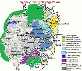
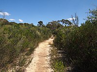
There are 79 vegetation communities in the Sydney metropolitan area that are identified, described and mapped.[4] The combination of climate, topography, moisture, and soil influence the dispersion of these ecological communities across a height gradient from 0 to 200 metres (0 to 700 ft).[5] There are many hiking trails, paved and unpaved roads for exploring the many different biomes and ecosystems.[6][7][8]
Savannas (or grassy woodlands), the most predominant biome in the Sydney region,[9] mainly occur in the Cumberland Plain west of Sydney CBD, which generally feature eucalyptus trees that are usually in open, dry sclerophyll woodland areas with shrubs (typically wattles, callistemons, grevilleas and banksias) and sparse grass in the understory, reminiscent of Mediterranean forests.[10] The plants in this community tend to have rough and spiky leaves, as they are grown in areas with low soil fertility.
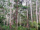
Wet sclerophyll forests, which are part of Eastern Australian temperate forests, have narrow, relatively tall, dense trees with a lush, moist understory of fleecy shrubs and tree ferns. They are mainly found in the wetter areas, such as Forest District and the North Shore.[11]
It has been calculated that around 98,000 hectares of native vegetation remains in the Sydney metropolitan area, shaping the geography of Sydney, about half of what is likely to have been existing at the time of European arrival.[12]
Historical descriptions edit
In 1787, Arthur Bowes Smyth from the First Fleet described the landscape as "...fresh terraced, lawns and grottos with distinct plantations of the tallest and most stately trees I ever saw in any nobleman's grounds in England, cannot excel in beauty those whose nature now presented to our view." Furthermore, early settlers compared the landscapes to the manicured parks of England which also featured well-spaced trees and a grassy understorey.[13]
In 1819, British settler William Wentworth described Sydney's vegetation and landform in great detail:
The colony of New South Wales possesses every variety of soil, from the sandy heath, and the cold hungry clay, to the fertile loam and the deep vegetable mould. For the distance of 5 mi (8.0 km) to 6 mi (9.7 km) from the coast, the land is in general extremely barren, being a poor hungry sand, thickly studded with rocks. A few miserable stunted gums, and a dwarf underwood, are the richest productions of the best part of it; while the rest never gives birth to a tree at all, and is only covered with low flowering shrubs, whose infinite diversity, however, and extraordinary beauty, render this wild heath the most interesting part of the country for the botanist, and make even the less scientific beholder forget the nakedness and sterility of the scene.
Beyond this barren waste, which thus forms a girdle to the coast, the country suddenly begins to improve. The soil changes to a thin layer of vegetable mould, resting on a stratum of yellow clay, which is again supported by a deep bed of schistus. The trees of the forest are here of the most stately dimensions. Full sized gums and iron barks, alongside of which the loftiest trees in this country would appear as pigmies, with the beefwood tree, or as it is generally termed, the forest oak, which is of much humbler growth, are the usual timber. The forest is extremely thick, but there is little or no underwood.
At this distance, however, the aspect of the country begins rapidly to improve. The forest is less thick, and the trees in general are of another description; the iron barks, yellow gums, and forest oaks disappearing, and the stringy barks, blue gums, and box trees, generally usurping their stead. When you have advanced about 4 mi (6.4 km) further into the interior, you are at length gratified with the appearance of a country truly beautiful. An endless variety of hill and dale, clothed in the most luxuriant herbage, and covered with bleating flocks and lowing herds, at length indicate that you are in regions fit to be inhabited by civilized man. The soil has no longer the stamp of barrenness. A rich loam resting on a substratum of fat red clay, several feet in depth, is found even on the tops of the highest hills, which in general do not yield in fertility to the valleys. The timber, strange as it may appear, is of inferior size, though still of the same nature, i. e. blue gum, box, and stringy bark. There is no underwood, and the number of trees upon an acre do not upon an average exceed thirty. They are, in fact, so thin, that a person may gallop without difficulty in every direction.[14]
In 1827, Peter Cunningham described the western plains of Sydney as "a fine timbered country, perfectly clear of bush...without any impediment in the shape of rocks, scrubs, or close forest".[15]
Biomes edit


- Rainforests
- North Coast Warm Temperate Rainforests – Dominated by Ceratopetalum apetalum, Doryphora sassafras and Acmena smithii, it is scarcely present in the RNP and Hacking River valley in around Sutherland in southern Sydney, and predominant in the Ku-ring-gai Chase National Park and Turramurra in Northern Sydney, near Hornsby.[16]
- Dry Rainforests or Western Sydney Dry Rainforest – It is very thinly distributed across the dry areas to the south of Blue Mountains and in small portions in Calmsley Hill Farm in Western Sydney Parklands, near Abbotsbury, New South Wales, and as well as in the Camden area, but in fragments. They have Alectryon subcinereus as one of the tree covers and Clerodendrum tomentosum as shrubby covers.[17]
- Littoral Rainforests – Dominated by Acmena smithii, Ficus rubiginosa, and Elaeodendron australe, it occurs in sporadic areas in northern Illawarra to Royal National Park (near Bundeena and in Towra Point Nature Reserve in Sutherland Shire), and also in one diminutive area in Northern Beaches Council (Mona Vale) in the Northern Suburbs to Newcastle.[18]
- Wet scleropyhll forests
- North Coast Wet Sclerophyll Forests – Dominated by tall Eucalyptus saligna and Eucalyptus pilularis, karrabina, peppermints, Eucalyptus oreades and Eucalyptus globulus, and receiving high amount of rainfall (above 1000 mm), it is present in Ku-ring-gai Council, Hornsby Shire, Narrabeen, Lane Cove, Pennant Hills and Castle Hill in the north, and in the Illawara region, with small portions in Ryde, North Parramatta and Pittwater.[19][20][21]
- The Blue Gum High Forest – Strictly found in northern parts of Sydney, it is a wet sclerophyll forest where the annual rainfall is over 1100 mm (43 in), with its trees between 20 and 40 metres tall.[22]
- Northern Hinterland Wet Sclerophyll Forests – Dominated by Eucalyptus resinifera and Syncarpia glomulifera, it was once extensive on the north shore across the local government areas of Hornsby, Ku-ring-gai, Ryde, Willoughby, Lane Cove, Parramatta, Baulkham Hills and Blacktown to the north of Sydney, with small outliers in Menai, Bankstown and Auburn in the southwest.[23][24]
- Sydney turpentine ironbark forest – Characterized by thick shrubs and dominated by Syncarpia glomulifera, it is a tall open forest with trees as high as 30 metres and is found on shale and shale-meliorated soils found in small pockets at Campbelltown, Heathcote and Menai.[25][26]
- Southern Lowland Wet Sclerophyll Forests – Containing Corymbia maculata, it is found in upper Narrabeen, Pittwater, Woronora and Illawara, as well as on the foreshores of Hacking, Parramatta and Georges Rivers.[27]
- North Coast Wet Sclerophyll Forests – Dominated by tall Eucalyptus saligna and Eucalyptus pilularis, karrabina, peppermints, Eucalyptus oreades and Eucalyptus globulus, and receiving high amount of rainfall (above 1000 mm), it is present in Ku-ring-gai Council, Hornsby Shire, Narrabeen, Lane Cove, Pennant Hills and Castle Hill in the north, and in the Illawara region, with small portions in Ryde, North Parramatta and Pittwater.[19][20][21]
- Grassy Woodlands/Savannas
- Cumberland Plain Woodland – These are shrub and grass eucalyptus communities located in areas of low to moderate rainfall (less than 950 millimetres annually) and are most commonly found in large parts of the Sydney metropolitan area, namely in Western Sydney or the Cumberland Plain. Moist Shale Woodlands[28] also exist within this biome, but they are distinguished by their lusher plant habitats.[29] It is a dry woodland remnant containing waxy-leaved shrubs, twiners, herbs and small trees in a grassy understorey.[30] It has a number of sub-regions: Moist Shale Woodlands, Western Sydney dry rainforest, and Shale sandstone transition forest, among others.[31]
- Dry sclerophyll forests
- Sydney Coastal Dry Sclerophyll Forests – Predominant on the northeast parts of the Woronora Plateau on ridgelines within the Royal, Heathcote and Dharawal national parks and Garawarra State Conservation Area in southern Sydney. It is also present in north of Sydney Harbour and extends to both sides of the Hawkesbury River in Northern Beaches and Hornsby LGA's and Pennant Hills.[32][33]
- Sydney Hinterland Dry Sclerophyll Forests – Found in the drier parts (less than 950 mm) of the Woronora Plateau, also in Appin, Sandy Point, pockets in the southwestern edges of the Cumberland Plain (on the doorsteps of the Blue Mountains), and on the foreshores of the Hawkesbury River, it features 10–25 m tall eucalyptus trees with ostensible sclerophyll shrub understorey and open groundcover of sclerophyll sedges.[34][35]
- Cooks River/Castlereagh ironbark forest – Found in Castlereagh and Holsworthy, and a few remnants in the cities of Auburn, Bankstown and Liverpool, it is an ironbark shrub-grass forest located in western Sydney that sit on gravelly-clay soils and is made up of a moderately tall open eucalyptus forest or woodland to a low compact brush of paperbarks with nascent eucalypts. Broad-leaved ironbark (Eucalyptus fibrosa) is the most commonly spotted tree.[23][36]
- Sydney Sand Flats Dry Sclerophyll Forests – Present in northern Holsworthy with smaller examples at Rookwood and Villawood and is dominated by Eucalyptus sclerophylla.[37]
- Coastal Dune Dry Sclerophyll Forests – Examples are found at Bundeena, Kurnell and La Perouse in southern Sydney containing a collection of sclerophyllous shrub and heath species and a ferny ground cover.[38]
- Heathlands
- Wallum Sand Heaths – Present in Pleistocene sand dunes sitting high on sandstone cliff tops between Bundeena in Royal NP, Woollahra, Kurnell peninsula, Narrabeen and Sydney Heads which contain Allocasuarina distyla, Banksia serrata and Banksia aemula. There are also a wide variety of woody species such as tea-trees, grevilleas, peas and wattles. The ground layer comprises on open cover of sedges and forbs.[39]
- Sydney Coastal Heaths – Found extensively in the Sydney metropolitan area and in the eastern parts of the Woronora and Hornsby plateaus particularly in Royal and Ku-ring-gai national parks with prominence of Eucalyptus luehmanniana.[40] Heaths on coastal headlands are found in and around Garie Beach on the outskirts of southern Sydney, near Royal NP.[41]
- Scrublands/Shrublands
- Elderslie Banksia Scrub Forest – A critically endangered scrubby woodland community situated in southwestern Sydney that features a variety of stunted forest or woodland found on sandy substrates associated with deep Tertiary sand deposits. It has been reduced in extent of at least 90% of its original pre-European extent.[42]
- Castlereagh Scribbly Gum and Agnes Banks Woodlands – A small scrubby woodland community found in western Sydney with vegetation comprising low woodlands with sclerophyllous shrubs and an uneven ground layer of graminoids and forbs.[43]
- Sydney Sandstone Ridgetop Woodland – A shrubby woodland and mallee community situated in northern parts of Sydney on ridgetops and slopes of the Hornsby Plateau, Woronora Plateau and the lower Blue Mountains area. It is an area of high biodiversity, existing on poor sandstone soils, with regular wildfires, and moderate rainfall.[44][45]
- Freshwater Wetlands
- Castlereagh swamp woodland – A swampy sclerophyll forest affiliated with sporadically flooded soils containing Tertiary, Holocene and Quaternary sand deposits. It is found in low-elevated areas of Liverpool and in Voyager Point, and is made up of moderate to heavy cover of paperbark trees.[40]
- Coastal Heath Swamps – Common in Holsworthy defense area, Woronora catchment area and the Hornsby plateau including Garigal and Ku-ring-gai Chase national parks.[46]
- Coastal Freshwater Lagoons – Occurs on poorly drained alluvial flats and sand depressions and may be surrounded by broad-leaved cumbungi (Typha orientalis).[47]
- Forested wetlands
- Estuarine swamp oak forest – Found on the floodplains in most parts of metropolitan Sydney near streamlines, where Casuarina glauca (swamp oak) is the dominant species.[48]
- Sydney coastal river-flat forest – Found on the river flats of the coastal floodplains in most parts of Sydney that have rivers or creeks (and as well as other regions in eastern New South Wales). They are gallery forests that prominently features tall, open eucalypts and casuarinas that stand on silt, clay-loam and sandy loam soils on sporadically flooded alluvial flats, drainage lines and river terraces associated with coastal floodplains.[49][30]
- Coastal Swamp Forests – Occupies the low-lying coastal river flats, swamps and sand depressions, which are mostly cleared from the Sydney metropolitan area, but still exist in places like Georges River National Park, Milperra, Chipping Norton, Prospect Creek and Kurnell in southeastern Sydney, and Wheeler Heights, Narrabeen and Dee Why in the Northern Beaches.[50]
- Coastal Floodplain Wetlands – They cover a series of eucalypt and casuarina dominated communities found on low-lying coastal alluvial soils, such as in Georges River and its tributaries in northern Woronora and the lowlands of Blue Mountains. They are dominated by Microlaena stipoides.[51]
- Eastern Riverine Forests – Many riparian scrubs are found on rocky creeks that are enclosed with coarse sandy alluvial deposits with common vegetation being Tristaniopsis laurina.[52]
- Saline Wetlands
- Mangrove Swamps – Found in Towra, they are a basic community dominated by either Avicennia marina or Aegiceras corniculatum.[53]
- Saltmarshes – Usually located on estuarine alluvial soils, small tracts also exist on headlands exposed to prevailing sea spray.[54]
- Seagrass Meadows – Occurring on sandy nether of coastal estuaries and bays, they include a number of subaqueous aquatic species, such as eel grass (Zostera spp) and sea grass (Posidonia australis).[55]
Complete list edit
| Biomes | Eco-communities |
|---|---|
| Rainforests |
|
| Wet Sclerophyll Forests |
|
| Grassy Woodlands |
|
| Coastal Grasslands |
|
| Dry Sclerophyll Forests |
|
| Heathlands |
|
| Freshwater Wetlands |
|
| Forested Wetlands |
|
| Saline Wetlands |
|
Vegetation edit


The most widespread eucalyptus species in the Sydney region include:[33]
- Angophora costata (Sydney red gum)
- Eucalyptus amplifolia (cabbage gum)
- Eucalyptus piperita (Sydney peppermint)
- Eucalyptus sieberi (silvertop ash)
- Eucalyptus oblonga (stringybark)
- Eucalyptus capitellata (brown stringybark)
- Eucalyptus bosistoana (coast grey box)
- Eucalyptus moluccana (grey box)
- Corymbia gummifera (red bloodwood)
- Eucalyptus racemosa (snappy gum)
- Eucalyptus haemastoma (scribbly gum)
- Corymbia maculata (spotted gum)
- Eucalyptus luehmanniana (yellow top mallee ash)
- Eucalyptus eugenioides (thin-leaved stringybark)
- Eucalyptus robusta (swamp mahogany)
- Eucalyptus baueriana (round leaf box)
- Eucalyptus longifolia (woollybutt)
- Eucalyptus paniculata (grey ironbark)
- Eucalyptus punctata (grey gum)
- Eucalyptus melliodora (yellow box)
Non-eucalyptus tree species:
- Araucaria cunninghamii (hoop pine)
- Araucaria bidwillii (bunya pine)
- Corymbia eximia (yellow bloodwood)
- Allocasuarina torulosa (forest oak)
- Melaleuca linariifolia (snow-in-summer)
- Melaleuca quinquenervia (broad-leaved paperbark)
- Melaleuca alternifolia (narrow-leaved paperbark)
- Melaleuca armillaris (bracelet honey myrtle)
- Melaleuca decora (white feather honeymyrtle)
- Tristaniopsis laurina (water gum)
- Acacia falcata (sickle wattle)
- Callitris endlicheri (black cypress pine)
- Grevillea robusta (Australian silver oak)
- Acacia longifolia (Sydney golden wattle)
- Acacia podalyriifolia (Mount Morgan wattle)
- Melaleuca quinquenervia (paperbark tea tree)
- Syncarpia glomulifera (turpentine tree)
- Syzygium smithii (black cypress pine)
- Banksia integrifolia (coast banksia)
- Brachychiton acerifolius (Illawarra flame tree)
- Brachychiton populneus (kurrajong)
- Melaleuca viminalis (weeping bottlebrush)
- Cupaniopsis anacardioides (tuckeroo)
- Ficus macrophylla (Moreton Bay fig)
- Ficus microcarpa (Hill's weeping fig)
- Ficus rubiginosa (Port Jackson's fig)
- Flindersia australis (crow's ash)
- Glochidion ferdinandi (cheese tree)
- Lophostemon confertus (brush box)
Common shrub species include, but are not limited to:
- Banksia serrata (old man banksia)
- Casuarina glauca (swamp oak)
- Ceratopetalum gummiferum (New South Wales Christmas bush)
- Lomandra longifolia (spiny-head mat-rush)
- Banksia spinulosa
- Xanthosia pilosa (woolly xanthosia)
- Banksia aemula (wallum banksia)
- Banksia robur (swamp banksia)
- Melaleuca citrina (lemon bottlebrush)
- Melaleuca linearis (narrow-leaved bottlebrush)
- Dichondra repens (kidney weed)
- Centella asiatica (Asiatic pennywort)
- Veronica plebeia (trailing speedwell)
- Ozothamnus diosmifolius (rice flower)
Introduced edit
Introduced shrubs and/or vines that are invasive species):[56]
- Olea africana (African olive)
- Gleditsia triacanthos (honey locust)
- Thunbergia grandiflora (blue skyflower)
- Alternanthera philoxeroides (alligator weed)
- Anredera cordifolia (Madeira-vine)
- Asparagus aethiopicus (asparagus fern)
- Lantana camara (West Indian lantana)
- Cestrum parqui (green cestrum)
- Senna pendula (Easter cassia)
- Opuntia monacantha (prickly pear)
- Ligustrum sinense (small-leaved privet)
- Solanum mauritianum (wild tobacco bush)
- Ricinus communis (castor oil plant)
- Murraya paniculata (orange jasmine)
- Ipomoea cairica (Cairo morning glory)
- Araujia sericifera (cruel vine)
- Cardiospermum grandiflorum (balloon vine creeper)
- Cortaderia selloana (pampas grass)
- Ipomoea indica (purple morning glory)
- Vinca major (blue perrywinkle)
- Passiflora suberosa (corky passion vine)
Hardiness zone edit
Due to the microclimate, the plant hardiness zone in the Sydney area would range:[57]
- Zone 11a (4.4 to 7.2°C):
- Sydney CBD
- Sydney Harbour
- North Sydney
- Lower North Shore, which includes Mosman Bay and Chatswood
- Zone 10b (1.7°C to 4.4°C):
- Northern Beaches
- Inner West
- City of Parramatta
- Eastern portion of Canterbury-Bankstown and Cumberland City Council (or eastwards from Lidcombe and Lakemba)
- North Shore
- Eastern suburbs
- Georges River Council
- Southern Sydney
- Zone 10a (-1.1°C to 1.7°C):
- Most of Cumberland Plain, which include the cities of Fairfield, Blacktown, Penrith, Liverpool and Campbelltown
- Hornsby Shire
- Hills District
- Zone 9b (-3.9°C to -1.1°C):
- City of Hawkesbury, which includes Richmond and Windsor
- Camden Council
- Wollondilly Shire
Wildlife edit


The fauna of the Sydney area is diverse and its urban area is home to variety of bird and insect species, and also a few bat, arachnid and amphibian species. Introduced birds such as the house sparrow, common myna and feral pigeon are ubiquitous in the CBD areas of Sydney.[58][59] Moreover, possums, bandicoots, rabbits, feral cats, lizards, snakes and frogs may also be present in the urban environment, albeit seldom in city centers.[60]
About 40 species of reptiles are found in the Sydney region and 30 bird species exist in the urban areas.[61][62][63] Sydney's outer suburbs, namely those adjacent to large parks, have a great diversity of wildlife.[64] Since European settlement and the subsequent bushland clearing for the increasing population, 60% of the original mammals are now considered endangered or vulnerable, and many reptile species are experiencing population diminution and are becoming elusive.[65]
Tetrapods edit
This list includes bird species that are widespread in the Sydney metropolitan area:[66]
- Australian magpie
- Australian raven
- Australian white ibis
- Bell miner
- Common starling
- Crested pigeon
- Eastern rosella
- Eastern spinebill
- Galah
- Grey butcherbird
- Laughing kookaburra
- Magpie lark
- Masked lapwing
- Noisy miner
- Pacific koel
- Pied currawong
- Rainbow lorikeet
- Spotted dove
- Silver gull
- Sulphur-crested cockatoo
- Superb fairy-wren
- Willie wagtail
Although not commonly spotted, these birds are also present in Sydney:[63]
- Australian king-parrot
- Brown goshawk
- Common bronzewing
- Eastern yellow robin
- Golden whistler
- Little wattlebird
- Little raven
- Nankeen kestrel
- New Holland honeyeater
- Pallid cuckoo
- Peregrine falcon
- Red-browed finch
- Red wattlebird
- Red-whiskered bulbul
- Silvereye
- Tawny frogmouth
- Turquoise parrot
- Whistling kite
- White-bellied sea-eagle
This list includes mammal, reptile and amphibian species that are spotted in the Sydney urban area:[67][68]
- Australian blue-tongued skink
- Australian green tree frog
- Australian water dragon
- Bibron's toadlet
- Bleating tree frog
- Broad-headed snake
- Brush-tailed phascogale
- Bush rat
- Common bent-wing bat
- Common brushtail possum
- Common ringtail possum
- Common garden skink
- Common death adder
- Diamond python
- Eastern brown snake
- East-coast free-tailed bat
- Great barred frog
- Giant burrowing frog
- Golden bell frog
- Golden water skink
- Feathertail glider
- Grey-headed flying fox
- Leaf green tree frog
- Long-nosed bandicoot
- Squirrel glider
- Sugar glider
- Three-toed earless skink
- Yellow-bellied glider
- Peron's tree frog
- Red-bellied black snake
- Snake-eyed skink
- Three-toed earless skink
Arthropods edit
This list includes insect, spider and centipede species that are commonly present in Sydney:[69]
- Australian carpet beetle
- Australian garden orb weaver spider
- Australian grapevine moth
- Australian painted lady
- Bess beetle
- Black house spider
- Emperor gum moth
- Giant centipede
- Green-head ant
- Imperial hairstreak
- Christmas beetle
- Funnel ant
- Green vegetable bug
- House centipede
- Katydid
- Orchard swallowtail butterfly
- Bronze flat
- Green vegetable bug
- Redback spiders
- Pill bug
- Plague soldier beetle
- Punctate flower chafer
- Redback spider
- Skull spider
- Sydney funnel-web spider
- Sydney huntsman spider
- Spider wasp
- Transverse ladybird
- Zizina labradus
- Pacific golden orb weaver[70]
See also edit
References edit
- ^ Benson, D.H. and Howell, J. (2000) Sydney’s Bushland — More than Meets the Eye, Royal Botanic Gardens, Sydney.
- ^ "The Native Vegetation of the Sydney Metropolitan Area Volume 2: Vegetation Community Profiles" (PDF). NSW Government Catchment Management Authority and Office of Environment & Heritage. Retrieved 30 January 2019.
- ^ Fairley, A.; Waterhouse, D. (2005). West Sydney Wild – Exploring Nature in Sydney's Western Suburbs. Dural, NSW: Rosenberg Publishing Pty Ltd.
- ^ The native vegetation of the Sydney metropolitan area by NSW Environment & Heritage. Retrieved 28 January 2023.
- ^ French K, Pellow B and Henderson M 2000, Vegetation of the Holsworthy Military area. Cunninghamia 6(4): 893-939.
- ^ SYDNEY WALKS by Sydney.com
- ^ The best bushwalks in and around Sydney by The Daily Telegraph
- ^ Sydney’s top 5 walks by NSW National Parks and Wildlife Service
- ^ "Coastal Valley Grassy Woodlands". NSW Environment & Heritage. Retrieved 15 December 2019.
- ^ "Dry sclerophyll forests (shrub/grass sub-formation)". NSW Environment & Heritage. Retrieved 15 October 2016.
- ^ "Wet sclerophyll forests (grassy sub-formation)". NSW Environment & Heritage. Retrieved 16 March 2017.
- ^ James, T. McDougall, L. and Benson, D.H. (1999) Rare Bushland Plants of Western Sydney, second edition, Royal Botanic Gardens, Sydney.
- ^ ABORIGINAL DESIGN PRINCIPLES DARUG COUNTRY SYDNEY HARBOUR BRIDGE CYCLEWAY ACCESS PROGRAM - NORTH. MARCH 2021. Retrieved 31 January 2023.
- ^ Statistical, Historical, and Political Description of NSW by William Charles Wentworth, 1819
- ^ Kohen, J. (September 1996). "The Impact of Fire: An Historical Perspective". Australian Plants Online. Society for Growing Australian Plants.
- ^ Bell SAJ and Driscoll C 2007, Vegetation of the Cessnock-Kurri Region, Cessnock LGA, New South Wales: Survey, Classification and Mapping. Unpublished Report to Department of Environment and Climate Change. Eastcoast Flora Survey. November 2007.
- ^ Tozer MG 2003, The native vegetation of the Cumberland Plain, western Sydney: systematic classification and field identification of communities. Cunninghamia 8:1-75.
- ^ Young B and Young A 2006, Understanding the Scenery: The Royal National Park with Heathcote National Park. Envirobook, Annandale NSW.
- ^ Biosphere Environmental Consultants Pty Ltd 2008, Ryde Flora and Fauna Study 2008. Unpublished report prepared for Ryde City Council.
- ^ Bangalay Ecological and Bushfire and Eastcoast Flora Survey 2011, Pittwater Vegetation Classification, Vegetation Mapping, pre-1750 Vegetation Mapping and Vegetation Profiles’. Report prepared for Pittwater Council.
- ^ Clarke PJ and Benson DH 1987, Vegetation Survey of Lane Cove River State Recreation Area. Royal Botanic Gardens, Sydney.
- ^ "Sydney Blue Gum High Forest" (PDF). Nationally Threatened Species and Ecological Communities. Environment.gov.au. Archived from the original (PDF) on 18 June 2012. Retrieved 16 May 2012.
- ^ a b Auburn Council 2004, Auburn Council State of the Environment Report 2003-2004. Auburn Council, Auburn
- ^ Bankstown City Council 2002, Bushland Plan of Management – Reserves at Lansdowne including Mirambeena Reserve, Lansdowne Reserve, Bogabilla Reserve and Amaroo Reserve. Unpublished report prepared for Bankstown City Council.
- ^ Andrew, D. (2001). Post fire vertebrate fauna survey: Royal and Heathcote National Parks and Garawarra State Recreation Area.
{{cite book}}:|work=ignored (help) - ^ "ENDANGERED ECOLOGICAL COMMUNITY INFORMATION: Sydney Turpentine-Ironbark Forest" (PDF). NSW Department of Environment & Climate Change. Ryde City Council. February 2004. Archived from the original (PDF) on 30 September 2007. Retrieved 2 July 2007.
- ^ Fairley A and Waterhouse D 2005, West Sydney Wild – Exploring Nature in Sydney’s Western Suburbs. Rosenberg Publishing Pty Ltd, Dural, NSW.
- ^ Baulkham Hills Shire Council 2007, The bushland of Hunts Creek Reserve and Seville Reserve. Baulkham Hills Shire Council, Sydney.
- ^ Earth Resource Analysis PL 1998, Cumberland Plains Woodland: Trial Aerial Photographic interpretation of remnant woodlands, Sydney. Unpublished report prepared for NSW National Parks and Wildlife Service – Sydney Zone.
- ^ a b James, T. (1997). Native flora in Western Sydney: Urban Bushland Biodiversity Survey. NSW National Parks & Wildlife Service.
- ^ Earth Resource Analysis PL (1998). Cumberland Plains Woodland: Trial Aerial Photographic interpretation of remnant woodlands, Sydney (Unpublished report).
{{cite book}}:|work=ignored (help) - ^ Andrew D 2001, Post fire vertebrate fauna survey : Royal and Heathcote National Parks and Garawarra State Recreation Area. Report to NSW National Parks and Wildlife Service Sydney South Region.
- ^ a b "Sydney Coastal Dry Sclerophyll Forests". NSW Environment & Heritage. Retrieved 17 September 2012.
- ^ Benson D and Howell J 1994b, Hawkesbury-Nepean Catchment Studies. Draft Explanatory Notes for the Wollongong 1:100 000 Map Sheet. Ecology Section, Royal Botanic Gardens, Sydney.
- ^ Tozer, M. G. (2003). "The native vegetation of the Cumberland Plain, western Sydney: systematic classification and field identification of communities". Cunninghamia. 8: 1–75.
- ^ Harden, G. J., ed. (2000–2002). The Flora of New South Wales. Vol. 1–2 (Revised ed.). University of New South Wales Press.
- ^ DECC 2008a, Protecting and restoring the Cumberland Plain Woodland community at Campbell Hill West Reserve, Chester Hill. Department of Environment and Climate Change NSW, Sydney South
- ^ Herbert C 1980, ‘Wianamatta Group and Mittagong Formation’ in C Herbert and R Helby (eds) A guide to the Sydney Basin. Department of Mineral Resources, Geological Survey of New South Wales Bulletin 26, 4-9.
- ^ Anne Clements and Associates 2003, Flora Assessment: Proposed "Banksia Grove" residential subdivision, Bundock St, Randwick. Unpublished report prepared for Bowen and Gerathy Solicitors.
- ^ a b DEC 2004, Eastern Suburbs Banksia Scrub Endangered Ecological Community Recovery Plan. NSW Department of Environment and Conservation, Hurstville.
- ^ Fullerton RN 1998, Community Structure of Cliff-Top Coastal Heathlands in Botany Bay National Park, Sydney. Submitted to the University of Technology, Sydney in partial fulfilment of the requirements for the degree of Doctor of Philosophy.
- ^ Conservation Advice1 for the Elderslie Banksia by the Department of Agriculture, Water and the Environment. Retrieved 14 September 2022.
- ^ Castlereagh Scribbly Gum and Agnes Banks Woodlands of the Sydney Basin Bioregion Department of the Environment (2022). Castlereagh Scribbly Gum and Agnes Banks Woodlands of the Sydney Basin Bioregion in Community and Species Profile and Threats Database, Department of the Environment, Canberra.
- ^ "Sydney Sandstone Ridgetop Woodland". Northern Beaches Council. Retrieved 15 November 2018.
- ^ "Urban Bushland in the Ryde LGA - Sydney Sandstone Ridgetop Woodland" (PDF). Ryde Council. Retrieved 15 November 2018.
- ^ Coast and Wetlands Society 1982, Temporal Changes in the Estuarine Flora and Fauna of Towra Point, Botany Bay. Unpublished report prepared for the Coastal Council of NSW.
- ^ Brunker RL and Rose G 1969, Sydney Basin, New South Wales, 1:500 000 geological sheet. Special edition., Geological Survey of New South Wales, 1vBryan, JH (1966), Sydney 1:250 000 Geological Sheet S1 56-5. Department of Mineral Resources Sydney NSW.
- ^ Swamp Oak Floodplain Forest of the New South Wales North Coast, Sydney Basin and South East Corner Bioregions - profile NSW Environment & Heritage. Retrieved 13 September 2022.
- ^ River-Flat Eucalypt Forest on Coastal Floodplains of the New South Wales North Coast, Sydney Basin and South East Corner Bioregions - profile by Office of Environment & Heritage (NSW Government)
- ^ Keith DA and Myerscough PJ 1993, Floristics and soil relations of Upland Swamp vegetation near Sydney. Australian Journal of Ecology 18:325-344
- ^ Harden GJ (ed.) 2000-2002, The Flora of New South Wales. Volume 1-2 (Revised Edition) New South Wales University Press.
- ^ AGC Woodward-Clyde Pty Ltd 1996, Cronulla Sewerage Treatment Plant Upgrade Environmental Impact Statement. Unpublished report prepared for Sydney Water.
- ^ Australian Littoral Society 1977, An Investigation of Management Options for Towra Point, Botany Bay. Australian National Parks and Wildlife Service, Canberra.
- ^ Keith DA and Scott J 2005, Native vegetation of coastal floodplains – a diagnosis of the major plant communities in New South Wales. Pacific Conservation Biology 11: 81-104
- ^ Adam P, Stricker P, Wiecek BM and Anderson DJ 1989, The vegetation of seacliffs and headlands in New South Wales, Australia. Australian Journal of Ecology 14, 515-547.
- ^ Humphries, S.E., Groves, R.H., and Mitchell, D.S. (1991) 'Plant Invasions of Australian Ecosystems. Kowari 2'
- ^ Australia Plant Hardiness Zone Map by PlantMaps
- ^ Hindwood, K. A. and McCill, A. R., 1958. The Birds of Sydney (Cumberland Plain) New South Wales. Roy. Zool. Soc. New South Wales.
- ^ "Sydney's flying foxes now Bundy's problem". North Queensland Register. 2 August 2012. Archived from the original on 30 December 2012. Retrieved 22 February 2014.
- ^ Williams, J. et al. 2001. Biodiversity, Australia State of the Environment Report 2001 (Theme Report), CSIRO Publishing on behalf of the Department of the Environment and Heritage, Canberra. ISBN 0-643-06749-3
- ^ Cogger, H.G. (2000). Reptiles and Amphibians of Australia. Reed New Holland.
- ^ Green, D., 1973. -Re reptiles of the outer north-western suburbs of Sydney. Herpetofauna 6 (2): 2-5.
- ^ a b Australian Museum Online. "Crows and Ravens". Archived from the original on 1 September 2007. Retrieved 12 August 2007.
- ^ Burton, Thomas C. (1993). "9. Family Microhylidae" (PDF). Fauna of Australia series, Environment Australia website. Canberra: Department of the Environment, Water, Heritage and the Arts, Australian Government. Archived from the original (PDF) on 20 March 2011. Retrieved 19 August 2010.
- ^ Merriam, C. and Wagner, J., 1992. Local extinctions, habitat fragmentation and ecozones. Pp. 150-69 in Landscape Boundaries: Biodiversity and Ecologicy by A. J. Hanron and F. De Castri. Springer: New York.
- ^ Dolby, Tim; Clarke, Rohan (2014). Finding Australian Birds. CSIRO Publishing. ISBN 9780643097667.
- ^ Cogger, H. G. (2000). Reptiles and Amphibians of Australia. Reed New Holland.
- ^ Green, D. (1973). "Re reptiles of the outer north-western suburbs of Sydney". Herpetofauna. 6 (2): 2–5.
- ^ Lomov, B. (2005). Plant-insect interactions as indicators for restoration ecology (PhD thesis). Sydney: University of Sydney.
- ^ Lowe, E.C.; Wilder, S.M.; Hochuli, D.F. (2016), "Persistence and survival of the spider Nephila plumipes in cities: do increased prey resources drive the success of an urban exploiter?", Urban Ecosyst, 19 (2): 705–720, doi:10.1007/s11252-015-0518-9, S2CID 16169674
External links edit
- Sydney Metropolitan Vegetation
- Urban Forest Strategy
- Wildlife of Sydney
- Birds of Sydney