
KNOWPIA
WELCOME TO KNOWPIA

Wila Qullu (Bolivia-Chile) 
Summary
Wila Qullu (Aymara wila red or blood, qullu mountain,[2] "red mountain", Hispanicized spelling Wila Kkollu), also Cerro Laguna (Spanish cerro hill, laguna lake, lagoon), is a 4,948-metre-high (16,234 ft) mountain in the Andes located on the border of Bolivia and Chile in the Cordillera Occidental. Wila Qullu lies between the Salar de Huasco in the Tarapacá Region of Chile and the Salar de Uyuni in Bolivia. On the Bolivian side it is situated in the Potosí Department, Daniel Campos Province, Llica Municipality, Canquella Canton, north of the village of Pampa Anta.
| Wila Qullu | |
|---|---|
| Cerro Laguna | |
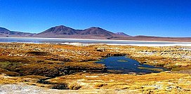 Salar de Huasco, Salar de Huasco National Park, Chile. Wila Qullu (on the left, half visible), Waylla East and Waylla West on the border of Bolivia and Chile | |
| Highest point | |
| Elevation | 4,948 m (16,234 ft)[1] |
| Coordinates | 20°20′13″S 68°39′38″W / 20.33694°S 68.66056°W |
| Geography | |
 Wila Qullu Location in Bolivia, on the border with Chile | |
| Location | Bolivia, Potosí Department Chile, Tarapacá Region |
| Parent range | Andes, Cordillera Occidental |
See also edit
References edit
- ^ upload.wikimedia.org
- ^ Radio San Gabriel, "Instituto Radiofonico de Promoción Aymara" (IRPA) 1993, Republicado por Instituto de las Lenguas y Literaturas Andinas-Amazónicas (ILLLA-A) 2011, Transcripción del Vocabulario de la Lengua Aymara, P. Ludovico Bertonio 1612 (Spanish-Aymara-Aymara-Spanish dictionary)
External links edit
- Llica Municipality: population data and map showing Canquella Canton and the village Pampa Anta. Wila Qullu is situated north of it on the border.