An orthographic projection of Oceania
Oceania OH -s(h)ee-AH -nee-ə, -AY -OH -shee-A(H)N -ee-əgeographical region comprising Australasia , Melanesia , Micronesia , and Polynesia . Spanning the Eastern and Western Hemispheres , at the centre of the water hemisphere , Oceania is estimated to have a land area of about 9,000,000 square kilometres (3,500,000 sq mi) and a population of around 44.4 million as of 2022. When compared to the other continents, Oceania is the smallest in land area and the second-least populated after Antarctica .
Oceania has a diverse mix of economies from the highly developed and globally competitive financial markets of Australia , French Polynesia , Hawaii , New Caledonia , and New Zealand , which rank high in quality of life and Human Development Index , to the much less developed economies of Kiribati , Papua New Guinea , Tuvalu , Vanuatu , and Western New Guinea , while also including medium-sized economies of Pacific islands such as Fiji , Palau , and Tonga . The largest and most populous country in Oceania is Australia, and the largest city is Sydney. Puncak Jaya in Highland Papua , Indonesia , is the highest peak in Oceania at 4,884 m (16,024 ft).
The arrival of European settlers in subsequent centuries resulted in a significant alteration in the social and political landscape of Oceania. The Pacific theatre saw major action during the First World War with the Japanese occupying many German territories. During the Second World War , Allied powers the United States , Philippines (a U.S. Commonwealth at the time) and Australia fought against Axis power Japan across various locations in Oceania. (Full article...
Refresh with new selections below (purge)
Selected geographic article - show another
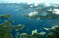
Bougainville and neighbouring islands
Bougainville Island Tok Pisin : Bogenvil ) is the main island of the Autonomous Region of Bougainville , which is part of Papua New Guinea . Its land area is 9,300 km2 (3,600 sq mi). The population of the whole province, including nearby islets such as the Carterets , is approximately 300,000 (2019 census). The highest point is Mount Balbi , on the main island, at 2,715 m (8,907 ft).
The much smaller
Buka Island ,
c. 500 km2 (190 sq mi) , lies to the north, across the 400–500 m (1,300–1,600 ft) wide
Buka Strait . Even though the strait is narrow, there is no bridge across it, but there is a regular ferry service between the key settlements on either side. The main airstrip in the north is in the town of Buka. Buka has an outcropping that is 175 km (109 mi) from
New Ireland . Among the large islands of Papua New Guinea, New Ireland is the closest to Buka. (
Full article... )
List of geographic articles
Selected article - show another
Moai facing inland at Ahu Tongariki , restored by Chilean archaeologist Claudio Cristino in the 1990s Moai moʻai ( MOH -eyeSpanish : moái ; Rapa Nui : moʻai , lit. monolithic human figures carved by the Rapa Nui people on Rapa Nui (Easter Island) in eastern Polynesia between the years 1250 and 1500. Nearly half are still at Rano Raraku , the main moai quarry, but hundreds were transported from there and set on stone platforms called ahu around the island's perimeter. Almost all moai have overly large heads, which account for three-eighths of the size of the whole statue. They also have no legs. The moai are chiefly the living faces (aringa ora ) of deified ancestors (aringa ora ata tepuna ).
The statues still gazed inland across their clan lands
when Europeans first visited the island in 1722 , but all of them had fallen by the latter part of the 19th century. The moai were toppled in the late 18th and early 19th centuries, possibly as a result of European contact or
internecine tribal wars . (
Full article... )
List of selected articles
Did you know - load new batch
General images - load new batch
The following are images from various Oceania-related articles on Wikipedia.
Image 1 King
Kamehameha I receiving the Russian naval expedition of
Otto von Kotzebue . Drawing by
Louis Choris in 1816. (from
Polynesia )
Image 2 Beach scenery at
Laura ,
Majuro , Marshall Islands (from
Micronesia )
Image 3 A common fishing canoe
va'a with outrigger in
Savaiʻi island,
Samoa , 2009 (from
Polynesia )
Image 4 German New Guinea before and after the German-Spanish treaty of 1899 (from
Micronesia )
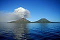
Image 5 Cinder plain of
Mount Yasur in
Vanuatu (from
Melanesia )
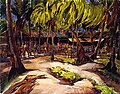
Image 6 Canoe carving on
Nanumea atoll, Tuvalu (from
Polynesia )
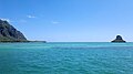
Image 7 Mokoliʻi Isle near
Oahu ,
Hawaii (from
Polynesia )
Image 8 Cook's Bay on
Moorea ,
French Polynesia (from
Polynesia )
Image 9 Kili Island is one of the smallest islands in the
Marshall Islands . (from
Micronesia )
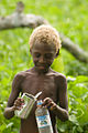
Image 10 A
Melanesian child from
Vanuatu (from
Melanesia )
Image 11 Moai at Ahu Tongariki on
Rapa Nui (from
Polynesia )
Image 12 Sailors of Melanesia in the
Pacific Ocean , 1846 (from
Melanesia )
Image 13 German trading station at
Jaluit Atoll with a Marshallese
korkor outrigger canoe in the foreground (from
Micronesia )
Image 14 Map showing the migration and expansion of the
Austronesians which began at about 3000 BC from
Taiwan . The Polynesian branch is shown in green. (from
Polynesia )
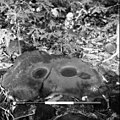
Image 15 Grinding stones discovered from
archaeology in Samoa (from
Polynesia )
Image 16 Polynesian (Hawaiian) navigators sailing multi-hulled
canoe , c. 1781 (from
Polynesia )
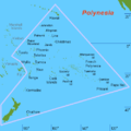
Image 17 Polynesia is generally defined as the islands within the
Polynesian Triangle . (from
Polynesia )
Image 21 An illustration of the Cross Spikes Club of the US Navy on
Bikini Atoll , one of several Marshall Islands used for
atomic bomb tests . (from
Micronesia )
Image 22 Polynesia is one of three major cultural areas of the
Pacific Ocean islands , along with
Melanesia and
Micronesia . (from
Polynesia )
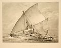
Image 23 Māori
war canoe drawn after
James Cook 's voyage to New Zealand. (from
Polynesia )
Image 25 A depiction of a royal
heiau (Hawaiian temple) at
Kealakekua Bay , c. 1816 (from
Polynesia )
Image 26 Image of the
Castle Bravo nuclear test, detonated on 1 March 1954, at
Bikini Atoll (from
Micronesia )
Image 28 On February 14, 1779, Capt.
James Cook was killed on the island of Hawaii (from
Polynesia )
Image 29 The arrival of
Abel Tasman in
Tongatapu , 1643; drawing by
Isaack Gilsemans (from
Polynesia )
Image 30 Outline of sovereign (dark orange) and dependent islands (bright orange) (from
Micronesia )
Image 31 Melanesia is one of three major cultural areas of the
Pacific Ocean islands , along with
Micronesia and
Polynesia . (from
Melanesia )
Image 33 Chronological dispersal of
Austronesian peoples across the
Indo-Pacific (from
Micronesia )
Image 34 Languages of Micronesia. (from
Micronesia )
Image 35 Chronological dispersal of
Austronesian peoples across the
Indo-Pacific (from
Melanesia )
Image 36 Carving from the ridgepole of a
Māori house, ca 1840 (from
Polynesia )
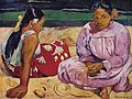
Image 37 Painting of
Tahitian Women on the Beach by
Paul Gauguin —
Musée d'Orsay (from
Polynesia )
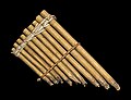
Image 38 A pan flute from
Solomon Islands , 19th century (from
Melanesia )
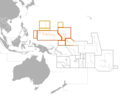
Image 39 Outline of sovereign (dark orange) and dependent islands (bright orange) (from
Melanesia )
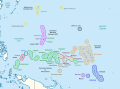
Image 40 Map of Melanesia, showing its location within Oceania (from
Melanesia )
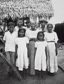
Image 41 Chamorro people in 1915 (from
Micronesia )
Image 42 Aerial view of
Solomon Islands (from
Melanesia )
Image 43 The Polynesian spread of colonization in the Pacific (from
Polynesia )
Image 45 Subregions (
Melanesia ,
Micronesia , Polynesia, and
Australasia ), as well as sovereign and dependent islands of
Oceania (from
Polynesia )
Image 47 Australia's concept of Australasia, which includes Australia, New Zealand and, in this case,
Melanesia (from
Australasia )
Image 48 Micronesia is one of three major cultural areas of the
Pacific Ocean islands , along with
Melanesia and
Polynesia . (from
Micronesia )
Image 49 Mount Marpi in
Saipan . (from
Micronesia )
Image 50 Polynesians with
outrigger canoes at
Waikiki Beach ,
Oahu Island , early 20th century (from
Polynesia )
Image 51 Subregions (
Melanesia ,
Micronesia ,
Polynesia and
Australasia ), as well as sovereign and dependent islands of
Oceania (from
Micronesia )
Image 52 Outline of sovereign (dark orange) and dependent islands (bright orange) (from
Polynesia )
Australasia Melanesia Micronesia Polynesia
Adamstown Pitcairn Islands 6 Alofi Niue 7 Apia Samoa Avarua Cook Islands 7 Fakaofo Tokelau 8 Funafuti Tuvalu Mata Utu Wallis and Futuna 2 Nukuʻalofa Tonga Pago Pago American Samoa 4 Papeete French Polynesia 2
Category puzzle Select [►] to view subcategories
Oceania
Dependent territories in Oceania
Administrative divisions in Oceania
Buildings and structures in Oceania
Organizations based in Oceania
Science and technology in Oceania
Here are some tasks awaiting attention:
The following Wikimedia Foundation sister projects provide more on this subject:
Commons
Wikibooks
Wikidata
Wikinews
Wikiquote
Wikisource
Wikiversity
Wikivoyage
Wiktionary
Wikipedia in other languages used in Oceania:
Discover Wikipedia using portals
List of all portals
The arts portal
Biography portal
Current events portal
Geography portal
History portal
Mathematics portal
Science portal
Society portal
Technology portal
Random portal
WikiProject Portals
Purge server cache