


Summary
Gennevilliers (French pronunciation: [ʒœnvilje] ⓘ) is a commune in the northwestern suburbs of Paris, in the Hauts-de-Seine department of Île-de-France. It is located 9.1 km (5.7 mi) from the centre of Paris.
Gennevilliers | |
|---|---|
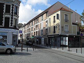 Town centre of Gennevilliers | |
 Coat of arms | |
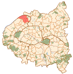 Paris and inner ring départements | |
Location of Gennevilliers .mw-parser-output .locmap .od{position:absolute}.mw-parser-output .locmap .id{position:absolute;line-height:0}.mw-parser-output .locmap .l0{font-size:0;position:absolute}.mw-parser-output .locmap .pv{line-height:110%;position:absolute;text-align:center}.mw-parser-output .locmap .pl{line-height:110%;position:absolute;top:-0.75em;text-align:right}.mw-parser-output .locmap .pr{line-height:110%;position:absolute;top:-0.75em;text-align:left}.mw-parser-output .locmap .pv>div{display:inline;padding:1px}.mw-parser-output .locmap .pl>div{display:inline;padding:1px;float:right}.mw-parser-output .locmap .pr>div{display:inline;padding:1px;float:left}html.skin-theme-clientpref-night .mw-parser-output .od,html.skin-theme-clientpref-night .mw-parser-output .od .pv>div,html.skin-theme-clientpref-night .mw-parser-output .od .pl>div,html.skin-theme-clientpref-night .mw-parser-output .od .pr>div{background:#000;color:#fff}html.skin-theme-clientpref-night .mw-parser-output .locmap{filter:grayscale(0.6)}@media(prefers-color-scheme:dark){html.skin-theme-clientpref-os .mw-parser-output .locmap{filter:grayscale(0.6)}html.skin-theme-clientpref-os .mw-parser-output .od,html.skin-theme-clientpref-os .mw-parser-output .od .pv>div,html.skin-theme-clientpref-os .mw-parser-output .od .pl>div,html.skin-theme-clientpref-os .mw-parser-output .od .pr>div{background:#000;color:#fff}}  Gennevilliers  Gennevilliers | |
| Coordinates: 48°56′00″N 2°18′00″E / 48.9333°N 2.3000°E | |
| Country | France |
| Region | Île-de-France |
| Department | Hauts-de-Seine |
| Arrondissement | Nanterre |
| Canton | Gennevilliers |
| Intercommunality | Grand Paris |
| Government | |
| • Mayor (2020–2026) | Patrice Leclerc[1] |
| Area 1 | 11.64 km2 (4.49 sq mi) |
| Population (2021)[2] | 49,410 |
| • Density | 4,200/km2 (11,000/sq mi) |
| Time zone | UTC+01:00 (CET) |
| • Summer (DST) | UTC+02:00 (CEST) |
| INSEE/Postal code | 92036 /92230 |
| Elevation | 21–33 m (69–108 ft) |
| 1 French Land Register data, which excludes lakes, ponds, glaciers > 1 km2 (0.386 sq mi or 247 acres) and river estuaries. | |
History edit

On 9 April 1929, one-fifth of the territory of Gennevilliers was detached and became the commune of Villeneuve-la-Garenne. Gennevilliers is the site of the main river port Port of Gennevilliers of Paris on the Seine.
Population edit
|
| ||||||||||||||||||||||||||||||||||||||||||||||||||||||||||||||||||||||||||||||||||||||||||||||||||||||||||||||||||
| Source: EHESS[3] and INSEE (1968-2017)[4] | |||||||||||||||||||||||||||||||||||||||||||||||||||||||||||||||||||||||||||||||||||||||||||||||||||||||||||||||||||
Transport edit
Gennevilliers is served by three stations on Paris Métro Line 13: Les Courtilles, Les Agnettes and Gabriel Péri. All three are at the border with the commune of Asnières-sur-Seine.
Gennevilliers is also served by two stations on RER C (Les Grésillons and Gennevilliers), as well as five stops on Île-de-France tramway Line 1.
Education edit
Schools in Gennevilliers include:
- 13 preschools[5]
- 9 primary schools[6]
- 3 junior high schools: Collège Guy-Môquet, Collège Édouard-Vaillant, Collège Louis-Pasteur[7]
There is a senior high school, Lycée Galilée.[8]
Natives/residents edit
- Isabelle Adjani, actress
- Pascal Tayot, French judoka who won a silver medal at the 1992 Summer Olympics
- Thierry Vigneron, pole vault bronze medalist and former record holder
- Garra Dembélé, footballer
- Wesley Jobello, footballer
- David N'Gog, footballer (Bolton Wanderers, Liverpool F.C.)
- Édouard Roger-Vasselin, tennis player
- Jeanine Claes, dancer
Twin towns – sister cities edit
See also edit
References edit
- ^ "Répertoire national des élus: les maires". data.gouv.fr, Plateforme ouverte des données publiques françaises (in French). 2 December 2020.
- ^ "Populations légales 2021". The National Institute of Statistics and Economic Studies. 28 December 2023.
- ^ Des villages de Cassini aux communes d'aujourd'hui: Commune data sheet Gennevilliers, EHESS (in French).
- ^ Population en historique depuis 1968, INSEE
- ^ "Écoles maternelles Archived 2016-09-30 at the Wayback Machine." Genevilliers. Retrieved on September 7, 2016.
- ^ "Écoles élémentaires[permanent dead link]." Genevilliers. Retrieved on September 7, 2016.
- ^ "Collèges Archived 2016-09-30 at the Wayback Machine." Gennevilliers. Retrieved on September 7, 2016.
- ^ "Lycée Galilée." Gennevilliers. Retrieved on September 7, 2016.
- ^ "Relations internationales". ville-gennevilliers.fr (in French). Gennevilliers. Retrieved 2019-11-14.
External links edit
- Official website