


Summary
Pujaut (French pronunciation: [pyʒo]; Occitan: Puejaut) is a commune in the Gard department in southern France. The village is situated on the south side of a small hill overlooking a flat plain that once formed the bed of a lake. The lake was drained at the beginning of the 17th century. The village is located 3.5 km west of the Rhône, 4.5 km north of Villeneuve-lès-Avignon and 5 km south of Roquemaure. In 2017 the commune had a population of 4,136.
Pujaut | |
|---|---|
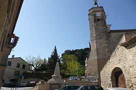 The church of Pujaut | |
 Coat of arms | |
Location of Pujaut .mw-parser-output .locmap .od{position:absolute}.mw-parser-output .locmap .id{position:absolute;line-height:0}.mw-parser-output .locmap .l0{font-size:0;position:absolute}.mw-parser-output .locmap .pv{line-height:110%;position:absolute;text-align:center}.mw-parser-output .locmap .pl{line-height:110%;position:absolute;top:-0.75em;text-align:right}.mw-parser-output .locmap .pr{line-height:110%;position:absolute;top:-0.75em;text-align:left}.mw-parser-output .locmap .pv>div{display:inline;padding:1px}.mw-parser-output .locmap .pl>div{display:inline;padding:1px;float:right}.mw-parser-output .locmap .pr>div{display:inline;padding:1px;float:left}html.skin-theme-clientpref-night .mw-parser-output .od,html.skin-theme-clientpref-night .mw-parser-output .od .pv>div,html.skin-theme-clientpref-night .mw-parser-output .od .pl>div,html.skin-theme-clientpref-night .mw-parser-output .od .pr>div{background:#000;color:#fff}html.skin-theme-clientpref-night .mw-parser-output .locmap{filter:grayscale(0.6)}@media(prefers-color-scheme:dark){html.skin-theme-clientpref-os .mw-parser-output .locmap{filter:grayscale(0.6)}html.skin-theme-clientpref-os .mw-parser-output .od,html.skin-theme-clientpref-os .mw-parser-output .od .pv>div,html.skin-theme-clientpref-os .mw-parser-output .od .pl>div,html.skin-theme-clientpref-os .mw-parser-output .od .pr>div{background:#000;color:#fff}}  Pujaut  Pujaut | |
| Coordinates: 44°00′20″N 4°46′31″E / 44.0056°N 4.7753°E | |
| Country | France |
| Region | Occitania |
| Department | Gard |
| Arrondissement | Nîmes |
| Canton | Villeneuve-lès-Avignon |
| Intercommunality | CA Grand Avignon |
| Government | |
| • Mayor (2020–2026) | Sandrine Soulier[1] |
| Area 1 | 23.5 km2 (9.1 sq mi) |
| Population (2021)[2] | 3,908 |
| • Density | 170/km2 (430/sq mi) |
| Time zone | UTC+01:00 (CET) |
| • Summer (DST) | UTC+02:00 (CEST) |
| INSEE/Postal code | 30209 /30131 |
| Elevation | 20–168 m (66–551 ft) (avg. 110 m or 360 ft) |
| 1 French Land Register data, which excludes lakes, ponds, glaciers > 1 km2 (0.386 sq mi or 247 acres) and river estuaries. | |
Geography edit
Climate edit
Pujaut has a hot-summer Mediterranean climate (Köppen climate classification Csa). The average annual temperature in Pujaut is 14.6 °C (58.3 °F). The average annual rainfall is 672.8 mm (26.49 in) with November as the wettest month. The temperatures are highest on average in July, at around 23.9 °C (75.0 °F), and lowest in January, at around 6.3 °C (43.3 °F). The highest temperature ever recorded in Pujaut was 41.1 °C (106.0 °F) on 28 June 2019; the coldest temperature ever recorded was −10.3 °C (13.5 °F) on 2 January 2002.
| Climate data for Pujaut (1991−2020 normals, extremes 1991−present) | |||||||||||||
|---|---|---|---|---|---|---|---|---|---|---|---|---|---|
| Month | Jan | Feb | Mar | Apr | May | Jun | Jul | Aug | Sep | Oct | Nov | Dec | Year |
| Record high °C (°F) | 20.8 (69.4) |
24.2 (75.6) |
26.7 (80.1) |
30.4 (86.7) |
33.9 (93.0) |
41.1 (106.0) |
39.9 (103.8) |
41.0 (105.8) |
35.3 (95.5) |
31.0 (87.8) |
23.2 (73.8) |
19.8 (67.6) |
41.1 (106.0) |
| Mean daily maximum °C (°F) | 10.5 (50.9) |
12.2 (54.0) |
16.4 (61.5) |
19.4 (66.9) |
23.6 (74.5) |
28.0 (82.4) |
30.8 (87.4) |
30.6 (87.1) |
25.5 (77.9) |
20.6 (69.1) |
14.4 (57.9) |
10.9 (51.6) |
20.2 (68.4) |
| Daily mean °C (°F) | 6.3 (43.3) |
7.2 (45.0) |
10.6 (51.1) |
13.2 (55.8) |
17.2 (63.0) |
21.3 (70.3) |
23.9 (75.0) |
23.6 (74.5) |
19.3 (66.7) |
15.3 (59.5) |
10.1 (50.2) |
6.8 (44.2) |
14.6 (58.3) |
| Mean daily minimum °C (°F) | 2.0 (35.6) |
2.2 (36.0) |
4.7 (40.5) |
7.1 (44.8) |
10.8 (51.4) |
14.7 (58.5) |
17.0 (62.6) |
16.7 (62.1) |
13.0 (55.4) |
10.1 (50.2) |
5.7 (42.3) |
2.7 (36.9) |
8.9 (48.0) |
| Record low °C (°F) | −10.3 (13.5) |
−7.5 (18.5) |
−9.2 (15.4) |
−3.7 (25.3) |
1.7 (35.1) |
5.7 (42.3) |
7.3 (45.1) |
7.6 (45.7) |
3.7 (38.7) |
−2.5 (27.5) |
−7.4 (18.7) |
−9.0 (15.8) |
−10.3 (13.5) |
| Average precipitation mm (inches) | 53.3 (2.10) |
35.3 (1.39) |
38.2 (1.50) |
60.8 (2.39) |
51.9 (2.04) |
39.4 (1.55) |
31.4 (1.24) |
36.9 (1.45) |
93.2 (3.67) |
88.2 (3.47) |
95.9 (3.78) |
48.3 (1.90) |
672.8 (26.49) |
| Average precipitation days (≥ 1.0 mm) | 5.7 | 4.5 | 4.4 | 6.5 | 6.0 | 4.1 | 3.1 | 3.5 | 5.3 | 6.3 | 7.9 | 5.6 | 62.8 |
| Source: Météo-France[3] | |||||||||||||
Population edit
|
| ||||||||||||||||||||||||||||||||||||||||||||||||||||||||||||||||||||||||||||||||||||||||||||||||||||||||||||||||||
| Source: EHESS[4] and INSEE (1968-2017)[5] | |||||||||||||||||||||||||||||||||||||||||||||||||||||||||||||||||||||||||||||||||||||||||||||||||||||||||||||||||||
See also edit
References edit
- ^ "Répertoire national des élus: les maires". data.gouv.fr, Plateforme ouverte des données publiques françaises (in French). 2 December 2020.
- ^ "Populations légales 2021". The National Institute of Statistics and Economic Studies. 28 December 2023.
- ^ "Fiche Climatologique Statistiques 1991-2020 et records" (PDF) (in French). Météo-France. Retrieved 3 September 2022.
- ^ Des villages de Cassini aux communes d'aujourd'hui: Commune data sheet Pujaut, EHESS (in French).
- ^ Population en historique depuis 1968, INSEE
Further reading edit
- Chardon, Michel (1975). "L'évolution morphologique des régions à l'Ouest du Rhône entre l'Ardoise et Aramon. Le réseau hydrographique et son évolution au Quaternaire. Versants et cuvettes de la dépression de Pujaut". Revue de géographie alpine (in French). 63 (3): 313–328. doi:10.3406/rga.1975.1424.
- Coulondres, Alfred (1877). "Notice sur la dessèchement des étangs de Rochefort et Pujaut". Mémoires & comptes-rendus de la Société scientifique et littéraire d'Alais (in French). 8 (Année 1876): 15–54.
- Jouffret, Marcel (1992). Pujaut, Mon Village. Nîmes, France: C. Lacour. ISBN 978-2-86971-646-9.
External links edit
- Village council website (in French)