


Summary
There are 73 sites in the National Register of Historic Places listings in West Side, Chicago, out of more than 350 listings in the City of Chicago. The West Side is defined for this article as the area north of the Chicago Sanitary and Ship Canal, south of Fullerton Avenue, west of the Chicago River and east of the western city limits. One site, Logan Square Boulevards Historic District, spans a border and is included also in listings on the North Side. The Chicago Sanitary and Ship Canal Historic District extends through Cook County west of Chicago, DuPage County and Will County to Lockport.
West Side Chicago listings on the National Register edit
The listed properties are distributed across 9 of the 77 well-defined community areas of Chicago.
This National Park Service list is complete through NPS recent listings posted May 10, 2024.[1]
| [2] | Name on the Register[3] | Image | Date listed[4] | Location | Neighborhood | Description |
|---|---|---|---|---|---|---|
| 1 | 7th District Police Station | 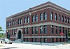 |
May 2, 1996 (#96000515) |
943-949 W. Maxwell Street 41°51′52″N 87°39′02″W / 41.864444°N 87.650556°W | Near West Side | Built in 1888. Romanesque Revival police station that served in pacifying the "Bloody Maxwell" area from 1888 to 1988.[5] |
| 2 | Austin Historic District | 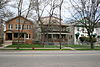 |
August 8, 1985 (#85001741) |
Roughly bounded by W. Ohio Street, N. Waller Avenue, N. Parkside Avenue, W. West End Avenue, & N. Mayfield Avenue & W. Corcoran Place 41°53′12″N 87°46′12″W / 41.886667°N 87.77°W | Austin | |
| 3 | Austin Town Hall Park Historic District |  |
November 15, 2006 (#06001015) |
Roughly bounded by W. Lake Street, N. Central Avenue, N. Parkside Avenue, and W. Race Avenue 41°53′18″N 87°45′57″W / 41.888333°N 87.765833°W | Austin | |
| 4 | Automatic Electric Company Building |  |
November 20, 2002 (#02001386) |
1001 W. Van Buren Street 41°52′35″N 87°39′08″W / 41.8763889°N 87.6522222°W | Near West Side | |
| 5 | Building at 900 West Lake Street |  |
February 12, 1999 (#99000163) |
900 W. Lake Street 41°53′09″N 87°39′00″W / 41.885833°N 87.65°W | Near West Side | |
| 6 | Central Park Theater | 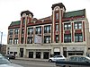 |
August 10, 2005 (#05000873) |
3535 W. Roosevelt Road 41°51′59″N 87°42′26″W / 41.866389°N 87.707222°W | North Lawndale | |
| 7 | Cermak Road Bridge Historic District |  |
May 1, 2012 (#12000243) |
W. Cermak Road. & the South Branch of the Chicago River 41°51′10″N 87°38′26″W / 41.852717°N 87.640522°W | Lower West Side | |
| 8 | Anton Cermak House |  |
February 4, 2011 (#10001201) |
2348 S. Millard Avenue 41°50′54″N 87°42′59″W / 41.848333°N 87.716389°W | South Lawndale | Former home of Chicago Mayor Anton Cermak |
| 9 | Chicago and North Western Railway Power House |  |
December 10, 2004 (#04001306) |
211 N. Clinton Street 41°53′11″N 87°38′28″W / 41.886432°N 87.641183°W | Near West Side | |
| 10 | Chicago Park Boulevard System Historic District |  |
December 18, 2018 (#12000040) |
Douglass Park, Gage, McKinley Park, Jackson Park, Sherman Park, Washington Park, Garfield Park & Humboldt Parks, E. Oakwood, S. Drexel Boulevards Coordinates missing | ||
| 11 | Chicago Sanitary and Ship Canal Historic District |  |
December 20, 2011 (#11000907) |
Illinois Waterway miles 290.0-321.7 41°50′05″N 87°41′42″W / 41.834669°N 87.694889°W | Lower West Side and South Lawndale | part of the Illinois Waterway Navigation System Facilities MPS; extends through Cook County west of Chicago, DuPage County and Will County to Lockport |
| 12 | Chicago Telephone Company Kedzie Exchange | 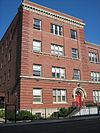 |
May 30, 2001 (#01000594) |
17 S. Homan Avenue 41°52′49″N 87°42′39″W / 41.880278°N 87.710833°W | East Garfield Park | |
| 13 | Church of the Epiphany |  |
February 5, 1998 (#98000067) |
201 S. Ashland Avenue 41°52′43″N 87°39′59″W / 41.878611°N 87.666389°W | Near West Side | |
| 14 | Columbus Park | 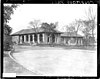 |
May 20, 1991 (#91000567) |
500 S. Central Avenue 41°52′28″N 87°46′10″W / 41.874444°N 87.769444°W | Austin | |
| 15 | Cook County Hospital Administration Building |  |
November 8, 2006 (#06001017) |
1835 W. Harrison Street 41°52′33″N 87°40′22″W / 41.875833°N 87.672778°W | Near West Side | |
| 16 | Creamery Package Manufacturing Company Building |  |
November 8, 2011 (#11000778) |
1245 W. Washington Boulevard 41°52′58″N 87°39′30″W / 41.882778°N 87.658333°W | Near West Side | |
| 17 | Dawson Brothers Plant | 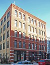 |
February 14, 1985 (#85000265) |
517-519 N. Halsted Street 41°53′31″N 87°38′50″W / 41.891944°N 87.647222°W | West Town | |
| 18 | East Village Historic District |  |
December 8, 2009 (#09000459) |
Bounded by W. Division Street, W. Chicago Avenue, N. Hermitage Avenue and N. Damen Avenue 41°53′59″N 87°40′26″W / 41.899633°N 87.673781°W | West Town | |
| 19 | First Congregational Church of Austin |  |
November 17, 1977 (#77000474) |
5701 W. Midway Park 41°53′19″N 87°46′05″W / 41.888611°N 87.768056°W | Austin | |
| 20 | Lucy Flower Technical High School for Girls |  |
May 8, 2017 (#100000960) |
3545 W. Fulton Boulevard 41°53′11″N 87°42′56″W / 41.886301°N 87.715442°W | East Garfield Park | |
| 21 | Jennie Foley Building |  |
June 19, 1985 (#85001274) |
626-628 S. Racine Avenue 41°52′24″N 87°39′25″W / 41.873333°N 87.656944°W | Near West Side | |
| 22 | Garfield Park |  |
August 31, 1993 (#93000837) |
100 N. Central Park Avenue 41°53′11″N 87°42′58″W / 41.886389°N 87.716111°W | East Garfield Park | |
| 23 | Abraham Groesbeck House |  |
February 4, 1993 (#92001841) |
1304 W. Washington Boulevard 41°52′59″N 87°39′36″W / 41.883056°N 87.66°W | Near West Side | |
| 24 | Guyon Hotel |  |
May 9, 1985 (#85000966) |
4000 W. Washington Boulevard 41°52′55″N 87°43′35″W / 41.881944°N 87.726389°W | West Garfield Park | |
| 25 | Holy Trinity Russian Orthodox Cathedral and Rectory | 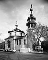 |
March 16, 1976 (#76000693) |
1117-1127 N. Leavitt Street 41°54′07″N 87°40′55″W / 41.901944°N 87.681944°W | West Town | |
| 26 | Home Bank and Trust Company |  |
February 21, 2007 (#07000061) |
1200 N. Ashland Avenue 41°54′14″N 87°40′05″W / 41.903889°N 87.668056°W | West Town | |
| 27 | Hull House |  |
October 15, 1966 (#66000315) |
800 S. Halsted Street 41°52′17″N 87°38′49″W / 41.871389°N 87.646944°W | Near West Side | |
| 28 | Humboldt Park |  |
February 20, 1992 (#92000074) |
Roughly bounded by N. Sacramento Boulevard and W. Augusta Boulevard, and N. Kedzie Avenue, W. North Avenue and N. California Avenue and W. Division Street 41°54′12″N 87°42′10″W / 41.903333°N 87.702778°W | West Town | |
| 29 | Immanuel Lutheran Church and Parsonage | April 15, 2024 (#100010215) |
1124-1134 S. Ashland Avenue 41°52′03″N 87°40′00″W / 41.8676°N 87.6666°W | Near West Side | ||
| 30 | International Tailoring Company Building |  |
April 18, 2008 (#07001474) |
847 W. Jackson Boulevard 41°52′40″N 87°38′57″W / 41.877706°N 87.649142°W | Near West Side | |
| 31 | Jewish People's Institute |  |
November 15, 1978 (#78001122) |
3500 W. Douglas Boulevard 41°51′47″N 87°42′47″W / 41.863056°N 87.713056°W | North Lawndale | |
| 32 | K-Town Historic District |  |
September 9, 2010 (#10000724) |
Bounded on the north by W. Cullerton Street; on the south by W. Cermak Road, on the west by S. Kostner Avenue, and on the east by S. Pulaski Road 41°51′11″N 87°43′47″W / 41.853056°N 87.729722°W | North Lawndale | |
| 33 | Patrick J. King House |  |
February 10, 1983 (#83000311) |
3234 W. Washington Boulevard 41°52′58″N 87°42′27″W / 41.882778°N 87.7075°W | East Garfield Park | |
| 34 | Laramie State Bank Building | April 20, 2023 (#100008873) |
5200 W. Chicago Avenue 41°53′42″N 87°45′21″W / 41.8950°N 87.7558°W | Austin | ||
| 35 | Henry E. Legler Regional Branch of the Chicago Public Library |  |
November 6, 1986 (#86003169) |
115 S. Pulaski Road 41°52′46″N 87°43′31″W / 41.879444°N 87.725278°W | West Garfield Park | |
| 36 | Lindemann and Hoverson Company Showroom and Warehouse |  |
November 26, 2008 (#08001095) |
2620 W. Washington Boulevard 41°52′59″N 87°41′31″W / 41.882944°N 87.692056°W | East Garfield Park | |
| 37 | Logan Square Boulevards Historic District |  |
November 20, 1985 (#85002901) |
W. Logan Boulevard, Logan Square, N. Kedzie Boulevard, Palmer Square, and N. Humboldt Boulevard 41°55′16″N 87°42′16″W / 41.92112°N 87.704385°W | Logan Square | Three boulevards connected by two parks, on both the North Side and West Sides. |
| 38 | Lou Mitchell's Restaurant |  |
May 5, 2006 (#06000376) |
565 W. Jackson Boulevard 41°52′38″N 87°38′30″W / 41.877222°N 87.641667°W | Near West Side | |
| 39 | Mid-City Trust and Savings Bank | August 23, 2023 (#100009254) |
801 W. Madison Street 41°52′54″N 87°38′51″W / 41.8817°N 87.6475°W | Near West Side | ||
| 40 | Midwest Athletic Club |  |
October 18, 1984 (#84000138) |
6 N. Hamlin Avenue 41°52′52″N 87°43′16″W / 41.881111°N 87.721111°W | West Garfield Park | |
| 41 | John Lothrop Motley School |  |
September 5, 2017 (#100001562) |
739 N. Ada Street 41°53′44″N 87°39′40″W / 41.895467°N 87.661124°W | West Town | |
| 42 | Notre Dame de Chicago |  |
March 7, 1979 (#79000826) |
1338 W. Flournoy Street 41°52′24″N 87°39′39″W / 41.873333°N 87.660833°W | Near West Side | |
| 43 | Otis Elevator Company Factory Building |  |
November 26, 2008 (#08001097) |
1435 W. 15th Street and 1501 S. Laflin Street 41°51′41″N 87°39′44″W / 41.861444°N 87.662278°W | Near West Side | |
| 44 | Elizabeth Peabody School |  |
December 26, 2017 (#100001923) |
1444 W. Augusta Boulevard 41°53′59″N 87°39′50″W / 41.899831°N 87.663755°W | West Town | |
| 45 | Pilsen Historic District |  |
February 1, 2006 (#10240018) |
Roughly bounded by W. 16th Street, W. Cermak Road, S. Halsted Street and S. Western Avenue 41°51′14″N 87°40′13″W / 41.853889°N 87.670278°W | Lower West Side | |
| 46 | Pioneer Trust and Savings Bank |  |
September 21, 2023 (#100009372) |
4000 W. North Avenue 41°54′36″N 87°43′35″W / 41.9100°N 87.7265°W | Humboldt Park | |
| 47 | Polish National Alliance Headquarters |  |
December 23, 2014 (#14001063) |
1514-1520 W. Division Street 41°54′12″N 87°39′57″W / 41.9034°N 87.6658°W | West Town | |
| 48 | Polish Roman Catholic Union of America |  |
January 2, 2013 (#12001114) |
984 N. Milwaukee Avenue 41°53′58″N 87°39′40″W / 41.899582°N 87.661141°W | West Town | |
| 49 | Produce Terminal Cold Storage Company Building |  |
June 22, 2003 (#03000538) |
1550 S. Blue Island Avenue 41°51′38″N 87°39′35″W / 41.860610°N 87.659609°W | Near West Side | |
| 50 | Pulaski Park and Fieldhouse |  |
August 13, 1981 (#81000217) |
1419 W. Blackhawk Street 41°54′21″N 87°39′47″W / 41.905833°N 87.663056°W | West Town | |
| 51 | Pyle-National Company Plant | January 19, 2021 (#100006017) |
1334 N. Kostner Avenue 41°54′21″N 87°44′11″W / 41.9057°N 87.7363°W | Humboldt Park | ||
| 52 | St. Ignatius College |  |
November 17, 1977 (#77000480) |
1076 W. Roosevelt Road 41°52′03″N 87°39′06″W / 41.8675°N 87.651667°W | Near West Side | |
| 53 | St. Matthew Evangelical Lutheran School | 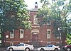 |
January 27, 2000 (#99001710) |
2101-2107 W. 21st Street 41°51′13″N 87°40′43″W / 41.853611°N 87.678611°W | Lower West Side | |
| 54 | St. Patrick's Roman Catholic Church |  |
July 15, 1977 (#77000481) |
718 W. Adams Street 41°52′45″N 87°38′40″W / 41.879167°N 87.644444°W | Near West Side | |
| 55 | Schoenhofen Brewery Historic District |  |
December 27, 1978 (#78001128) |
Roughly bounded by W. 16th Street, W. 18th Street, S. Canal Street, and S. Clinton Street 41°51′31″N 87°38′22″W / 41.858611°N 87.639444°W | Lower West Side | |
| 56 | Sears, Roebuck and Company Complex |  |
June 2, 1978 (#78001129) |
925 S. Homan Avenue 41°52′10″N 87°42′42″W / 41.869444°N 87.711667°W | North Lawndale | |
| 57 | Shedd Park Fieldhouse |  |
December 30, 1974 (#74000755) |
3660 W. 23rd Street 41°51′01″N 87°43′01″W / 41.850278°N 87.716944°W | South Lawndale | |
| 58 | J. P. Smith Shoe Company Plant |  |
November 14, 1985 (#85002842) |
685 N. Sangamon Avenue and 911 W. Huron Street 41°53′41″N 87°39′03″W / 41.894722°N 87.650833°W | West Town | |
| 59 | South Water Market |  |
August 20, 2004 (#04000870) |
Bounded by W. 14th Place, the 16th Street rail embankment, S. Racine Avenue, and S. Morgan Street 41°51′42″N 87°39′15″W / 41.861667°N 87.654167°W | Near West Side | |
| 60 | Stone Temple Baptist Church | December 21, 2022 (#100008484) |
3622 W. Douglas Boulevard 41°51′46″N 87°42′59″W / 41.8629°N 87.7163°W | North Lawndale | ||
| 61 | Storkline Furniture Corporation Factory | 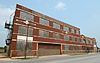 |
March 6, 2013 (#13000049) |
4400-4418 W. 26th Street 41°50′42″N 87°44′05″W / 41.844873°N 87.734741°W | South Lawndale | Destroyed in a fire in 2016.[6] |
| 62 | Story-Camp Rowhouses | 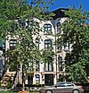 |
May 8, 1980 (#80001351) |
1526-1528 W. Monroe Street 41°52′48″N 87°39′57″W / 41.88°N 87.665833°W | Near West Side | |
| 63 | Third Church of Christ, Scientist |  |
October 24, 2016 (#16000733) |
2151 W. Washington Boulevard 41°52′59″N 87°40′53″W / 41.883021°N 87.681288°W | Near West Side | |
| 64 | Tri-Taylor Historic District |  |
March 3, 1983 (#83000315) |
Roughly bounded by S. Claremont Avenue, W. Harrison Street, S. Oakley Avenue, W. Polk Street, W. Ogden Avenue, and W. Roosevelt Road; also roughly bounded on the north by Oakley, Harrison, and Claremont Streets, and on the southeast by Taylor and Oakley Streets 41°52′13″N 87°41′00″W / 41.870278°N 87.683333°W | Near West Side | Second set of boundaries represents a boundary increase of February 3, 1988 |
| 65 | Union Park Congregational Church and Carpenter Chapel | 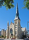 |
May 31, 2006 (#06000446) |
1613 W. Washington Boulevard 41°53′06″N 87°40′03″W / 41.885°N 87.6675°W | Near West Side | Now known as First Baptist Congregational Church; built in 1871; severely damaged in the February 2, 2011 blizzard[7] |
| 66 | Union Park Hotel |  |
June 7, 2010 (#10000309) |
1519-1521 W. Warren Boulevard 41°52′56″N 87°39′58″W / 41.882117°N 87.666117°W | Near West Side | |
| 67 | United States Customs House |  |
August 4, 2016 (#16000492) |
610 S. Canal Street 41°52′27″N 87°38′23″W / 41.874032°N 87.639589°W | Near West Side | |
| 68 | United States Post Office-Chicago |  |
August 16, 2001 (#01000868) |
433 W. Van Buren Street 41°52′34″N 87°38′19″W / 41.876111°N 87.638611°W | Near West Side | |
| 69 | Joseph J. Walser House |  |
April 23, 2013 (#13000185) |
42 N. Central Avenue 41°52′54″N 87°45′55″W / 41.881528°N 87.765286°W | Austin | Frank Lloyd Wright, 1903 |
| 70 | Seth Warner House |  |
June 3, 1982 (#82002531) |
631 N. Central Avenue 41°53′31″N 87°45′54″W / 41.891944°N 87.765°W | Austin | |
| 71 | West Jackson Boulevard District |  |
May 19, 1978 (#78001134) |
Roughly bounded by S. Laflin Avenue, S. Ashland Avenue, W. Adams Street, and W. Van Buren Street; also 1513 W. Adams Street 41°52′39″N 87°39′55″W / 41.8775°N 87.665278°W | Near West Side | Second set of boundaries represents a boundary increase of October 19, 1989 |
| 72 | Wholesale Florists Exchange |  |
November 22, 2011 (#11000849) |
1313 W. Randolph Street 41°53′03″N 87°39′34″W / 41.884167°N 87.659444°W | Near West Side | |
| 73 | Wicker Park Historic District |  |
June 20, 1979 (#79000831) |
Roughly bounded by N. Wood Street, W. Crystal Street, N. Caton Street, N. Claremont Avenue and W. North Avenue 41°54′26″N 87°40′20″W / 41.907222°N 87.672222°W | West Town |
Former listings edit
| [2] | Name on the Register | Image | Date listed | Date removed | Location | City or town | Description |
|---|---|---|---|---|---|---|---|
| 1 | Francisco Terrace Apartments |  |
March 26, 1973 (#73002260) | January 28, 1974 | 257 N. Francisco Avenue | East Garfield Park | Designed by Frank Lloyd Wright. Although it was demolished in 1974, the facade was moved to Oak Park in 1977. |
| 2 | Scoville Building |  |
July 31, 1973 (#73002261) | March 15, 1975 | 625 W. Washington Street | Near West Side | Demolished |
Key edit
| NRHP-listed | |
| ∞ | NRHP-listed Historic district |
| * | National Historic Landmark and NRHP-listed |
| ∞ | National Historic Landmark and NRHP-listed Historic district |
See also edit
References edit
- ^ National Park Service, United States Department of the Interior, "National Register of Historic Places: Weekly List Actions", retrieved May 10, 2024.
- ^ a b Numbers represent an alphabetical ordering by significant words. Various colorings, defined here, differentiate National Historic Landmarks and historic districts from other NRHP buildings, structures, sites or objects.
- ^ "National Register Information System". National Register of Historic Places. National Park Service. April 24, 2008.
- ^ The eight-digit number below each date is the number assigned to each location in the National Register Information System database, which can be viewed by clicking the number.
- ^ "History of Maxwell Street Station". University of Illinois at Chicago Police Department. University of Illinois. 2008-06-07. Archived from the original on 2012-06-29. Retrieved 2010-10-26.
- ^ "Crews Battle 5-Alarm Fire At Vacant Building In Little Village - CBS Chicago". www.cbsnews.com. 2016-11-05. Retrieved 2023-10-18.
- ^ Rhodes, Dawn. "Blizzard damage to historic church put at $1M". Chicago Tribune. Archived from the original on October 26, 2012. Retrieved February 17, 2011.
External links edit
- Chicago Listing on the National Register of Historic Places (2011)
- NPS−National Park Service: Focus database.