
KNOWPIA
WELCOME TO KNOWPIA

National Register of Historic Places listings in Northampton County, Pennsylvania 
Summary
This is a list of the National Register of Historic Places listings in Northampton County, Pennsylvania.

This is intended to be a complete list of the properties and districts on the National Register of Historic Places in Northampton County, Pennsylvania, United States.
There are 65 properties and districts listed on the National Register in the county, including 4 sites designated as National Historic Landmarks.
This National Park Service list is complete through NPS recent listings posted May 3, 2024.[1]
Current listings edit
| [2] | Name on the Register | Image | Date listed[3] | Location | Municipality | Description |
|---|---|---|---|---|---|---|
| 1 | Jacob Arndt House and Barn | 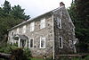 |
December 28, 2005 (#05001489) |
910 Raubsville Road 40°37′35″N 75°13′22″W / 40.626389°N 75.222778°W | Williams Township | |
| 2 | Bangor Historic District | 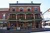 |
August 6, 2014 (#14000469) |
Roughly bounded by 3rd, Fairview & Pennsylvania Aves., Division, N. 4th, N. Main, Erdman, Northampton, S. 1st Sts. 40°51′57″N 75°12′19″W / 40.8657°N 75.2053°W | Bangor Borough | |
| 3 | Bath Crossroads Historic District | February 12, 2024 (#100009916) |
Roughly 12 blocks centered around Chestnut and Main streets 40°43′33″N 75°23′39″W / 40.7258°N 75.3941°W | Bath | ||
| 4 | Bethlehem Silk Mill | 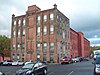 |
February 15, 2005 (#05000065) |
238 West Goepp Street 40°37′37″N 75°23′05″W / 40.626944°N 75.384722°W | Bethlehem | |
| 5 | Bethlehem Steel Lehigh Plant Mill No. 2 Annex |  |
May 5, 2004 (#04000401) |
11 West 2nd Street 40°36′55″N 75°22′46″W / 40.615278°N 75.379444°W | Bethlehem | |
| 6 | Bridge in Bangor Borough |  |
June 22, 1988 (#88000876) |
Pennsylvania Street over Martins Creek 40°52′10″N 75°12′28″W / 40.869444°N 75.207778°W | Bangor | |
| 7 | Bridge in Williams Township |  |
June 22, 1988 (#88000855) |
Legislative Route 48007 over Frey's Run near Stouts 40°36′39″N 75°13′54″W / 40.610833°N 75.231667°W | Williams Township | |
| 8 | Carbon County Section of the Lehigh Canal |  |
August 10, 1979 (#79002179) |
Along the Lehigh River 40°49′03″N 75°40′08″W / 40.8175°N 75.668889°W | Lehigh Township and Walnutport | Extends into Carbon County |
| 9 | Central Bethlehem Historic District | 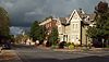 |
May 5, 1972 (#72001131) |
Bounded by Main, Nevada, and East Broad Streets, and the Lehigh River; also roughly bounded by Walnut St., Linden St., Lehigh River, and New St. 40°37′06″N 75°22′56″W / 40.618333°N 75.382222°W | Bethlehem | Second set of boundaries represents a boundary increase of November 7, 1988. Extends into Lehigh County |
| 10 | Chain Bridge |  |
February 12, 1974 (#74001798) |
Southwest of Glendon on Hugh Moore Parkway across the Lehigh River 40°39′14″N 75°14′56″W / 40.653889°N 75.248889°W | Palmer Township and Williams Township | |
| 11 | Coffeetown Grist Mill |  |
November 16, 1977 (#77001179) |
7 miles (11 km) south of Easton at Coffeetown and Kressman Roads 40°37′10″N 75°12′21″W / 40.619444°N 75.205833°W | Williams Township | |
| 12 | College Hill Residential Historic District |  |
May 1, 1991 (#91000506) |
Roughly bounded by McCartney Street, Pierce Street, Pardee Street, the Forks Township line and the Delaware River 40°42′17″N 75°12′17″W / 40.704722°N 75.204722°W | Easton | |
| 13 | County Bridge No. 36 |  |
June 22, 1988 (#88000877) |
Township Road 611 over Jacoby Creek 40°55′07″N 75°05′37″W / 40.918611°N 75.093611°W | Portland | |
| 14 | Delaware Division of the Pennsylvania Canal |  |
October 29, 1974 (#74001756) |
Parallels west bank of the Delaware River from Easton to Bristol 40°41′17″N 75°12′18″W / 40.688056°N 75.205°W | Bristol | Extends into Bucks County |
| 15 | Easton Cemetery |  |
October 25, 1990 (#90001610) |
401 North Seventh Street 40°41′55″N 75°13′07″W / 40.698611°N 75.218611°W | Easton | |
| 16 | Easton Historic District |  |
May 6, 1983 (#83002264) |
Roughly bounded by Riverside and Bushkill Drives, Ferry and 7th Streets 40°41′27″N 75°12′43″W / 40.6908°N 75.2119°W | Easton | |
| 17 | Easton House | 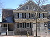 |
December 3, 1980 (#80003583) |
167–169 Northampton Street 40°41′29″N 75°12′29″W / 40.6914°N 75.2081°W | Easton | |
| 18 | Edelman Schoolhouse | 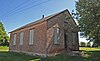 |
March 22, 2019 (#100003520) |
165 Longley Rd. 40°45′02″N 75°22′03″W / 40.7506°N 75.3675°W | Moore Township | |
| 19 | Ehrhart's Mill Historic District | 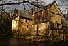 |
April 30, 1987 (#87000666) |
Old Mill Road 40°33′43″N 75°20′58″W / 40.5619°N 75.3494°W | Lower Saucon Township | |
| 20 | Elmwood Park Historic District | 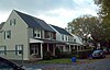 |
April 21, 1988 (#88000449) |
Roughly bounded by Goepp Circle, Woodruff Street, Park Place, and Carson Street 40°37′28″N 75°21′56″W / 40.6244°N 75.3656°W | Bethlehem | |
| 21 | Fountain Hill Historic District |  |
April 21, 1988 (#88000450) |
Roughly bounded by Brighton, Wyandotte, West Fourth and Seminole Streets, and Delaware Avenue 40°36′40″N 75°23′10″W / 40.6111°N 75.3861°W | Bethlehem | Extends into Lehigh County |
| 22 | Gemeinhaus-Lewis David De Schweinitz Residence |  |
May 15, 1975 (#75001658) |
66 West Church Street 40°37′07″N 75°22′52″W / 40.6186°N 75.3811°W | Bethlehem | |
| 23 | Gosztonyi Savings and Trust | 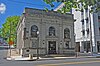 |
May 19, 2015 (#15000242) |
530 E. 3rd St. 40°36′44″N 75°22′15″W / 40.6121°N 75.3708°W | Bethlehem | |
| 24 | Gristmiller's House |  |
June 18, 1973 (#73001657) |
459 Old York Road 40°37′15″N 75°23′00″W / 40.6208°N 75.3833°W | Bethlehem | |
| 25 | Michael and Margaret Heller House | 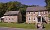 |
June 28, 2010 (#10000399) |
1890-1892 Friedensville Rd. 40°34′44″N 75°20′49″W / 40.5789°N 75.3469°W | Lower Saucon Township | |
| 26 | William Jacob Heller House | 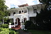 |
April 20, 1982 (#82003803) |
501 Mixsell Street 40°42′14″N 75°12′05″W / 40.7039°N 75.2014°W | Easton | |
| 27 | Historic Moravian Bethlehem District |  |
October 16, 2012 (#12001016) |
Church, Market and Main Streets 40°37′08″N 75°22′51″W / 40.6189°N 75.3808°W | Bethlehem | |
| 28 | Illick's Mill |  |
May 20, 2005 (#05000450) |
130 Illick's Mill Road 40°38′30″N 75°22′51″W / 40.6417°N 75.3808°W | Bethlehem | |
| 29 | Jacobsburg Historic District | 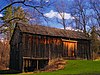 |
October 17, 1977 (#77001181) |
3 miles (4.8 km) northeast of Nazareth off Pennsylvania Route 115 40°46′57″N 75°17′34″W / 40.7825°N 75.2928°W | Nazareth | |
| 30 | Kreidersville Covered Bridge |  |
December 1, 1980 (#80003587) |
North of Northampton on Legislative Route 48061 40°43′25″N 75°29′35″W / 40.7236°N 75.4931°W | Allen Township | |
| 31 | R. K. Laros Silk Mill | 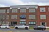 |
November 24, 2020 (#100005292) |
601-699 East Broad St. 40°37′20″N 75°21′46″W / 40.6222°N 75.3628°W | Bethlehem | |
| 32 | Lehigh Canal |  |
October 2, 1978 (#78002439) |
Lehigh Gap to south Walnutport boundary 40°44′49″N 75°36′18″W / 40.7469°N 75.605°W | Lehigh Township and Walnutport | |
| 33 | Lehigh Canal: Eastern Section Glendon and Abbott Street Industrial Sites | |
October 2, 1978 (#78002437) |
Lehigh River from Hopeville to confluence of Lehigh and Delaware Rivers 40°39′24″N 75°17′41″W / 40.6567°N 75.2947°W | Easton | Extends into Lehigh County |
| 34 | Lehigh Canal: Allentown to Hopeville Section |  |
December 17, 1979 (#79002307) |
Along Lehigh River 40°36′55″N 75°24′52″W / 40.6153°N 75.4144°W | Bethlehem | |
| 35 | Lehigh Water Gap Chain Bridge Toll House and East Bridge Abutment |  |
August 20, 2021 (#100006837) |
1309 Riverview Dr. 40°46′56″N 75°36′18″W / 40.7822°N 75.6051°W | Lehigh Township | |
| 36 | Lehigh Valley Railroad Headquarters Building |  |
May 24, 1984 (#84003517) |
425 Brighton Street 40°36′48″N 75°23′07″W / 40.6133°N 75.3853°W | Bethlehem | |
| 37 | Lehigh Valley Silk Mills |  |
April 29, 1993 (#93000356) |
Junction of Seneca and Clewell Streets 40°36′16″N 75°23′37″W / 40.6044°N 75.3936°W | Fountain Hill | |
| 38 | Lutz-Franklin School |  |
December 30, 2008 (#08001268) |
4216 Countryside Lane 40°37′28″N 75°16′49″W / 40.6244°N 75.2803°W | Lower Saucon Township | |
| 39 | C.F. Martin & Company | 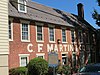 |
September 4, 2018 (#100002837) |
10 W North & 201 N Main Sts. 40°44′45″N 75°18′44″W / 40.7459°N 75.3121°W | Nazareth | |
| 40 | Mary Immaculate Seminary (MIS) |  |
April 11, 2022 (#100007566) |
300 Cherryville Rd. 40°44′08″N 75°31′20″W / 40.7355°N 75.5223°W | Northampton | |
| 41 | McCollum and Post Silk Mill |  |
July 27, 2005 (#05000758) |
368 Madison Avenue 40°44′21″N 75°19′08″W / 40.7392°N 75.3189°W | Nazareth | |
| 42 | Jacob Mixsell House | 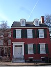 |
February 14, 1980 (#80003584) |
101 South 4th Street 40°40′50″N 75°12′37″W / 40.6806°N 75.2103°W | Easton | |
| 43 | Moravian Sun Inn | 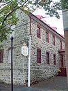 |
October 2, 1973 (#73001658) |
564 Main Street 40°37′19″N 75°22′54″W / 40.6219°N 75.3817°W | Bethlehem | |
| 44 | Nazareth Hall Tract |  |
November 28, 1980 (#80003588) |
Zinzendorf Square 40°44′40″N 75°18′54″W / 40.7444°N 75.315°W | Nazareth | |
| 45 | Nazareth Historic District |  |
August 11, 1988 (#88001203) |
Centered on Center and Main Streets 40°44′31″N 75°18′39″W / 40.7419°N 75.3108°W | Nazareth | |
| 46 | Jacob Nicholas House |  |
November 21, 1976 (#76001658) |
458 Ferry Street 40°41′22″N 75°12′47″W / 40.6894°N 75.2131°W | Easton | |
| 47 | Northampton County Bridge No. 15 |  |
August 31, 2020 (#100005519) |
Meadows Road west of PA 412/Leithsville Rd. and the Saucon Rail Trail 40°33′57″N 75°20′32″W / 40.5657°N 75.3422°W | Lower Saucon Township | |
| 48 | Old Waterworks |  |
June 19, 1972 (#72001142) |
Within Historic Subdistrict A near Monocacy Creek 40°37′09″N 75°23′00″W / 40.6192°N 75.3833°W | Bethlehem | |
| 49 | Packer Memorial Chapel |  |
November 20, 1979 (#79003234) |
Packer Avenue, Lehigh University 40°36′27″N 75°22′41″W / 40.6075°N 75.3781°W | Bethlehem | |
| 50 | Parsons-Taylor House |  |
August 22, 1980 (#80003585) |
4th and Ferry Streets 40°41′23″N 75°12′38″W / 40.6897°N 75.2106°W | Easton | |
| 51 | Pembroke Village Historic District |  |
May 9, 1988 (#88000464) |
Roughly bounded by Radclyffe Street, Carlisle Street, Stefko Boulevard, Arcadia Street and Minsi Trail 40°37′52″N 75°21′35″W / 40.6311°N 75.3597°W | Bethlehem | |
| 52 | Real Estate Building | 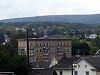 |
February 20, 1986 (#86000319) |
2–8 North Main Street 40°52′01″N 75°12′20″W / 40.8669°N 75.2056°W | Bangor | |
| 53 | Seipsville Hotel | 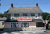 |
May 6, 1977 (#77001178) |
2912 Old Nazareth Road 40°41′37″N 75°15′45″W / 40.6936°N 75.2625°W | Palmer Township | |
| 54 | R. and H. Simon Silk Mill | 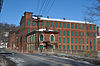 |
December 30, 2014 (#14001104) |
659 N. 13th St. 40°41′52″N 75°13′42″W / 40.6979°N 75.2282°W | Easton | |
| 55 | Herman Simon House | 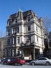 |
June 27, 1980 (#80003586) |
41 North 3rd Street 40°39′24″N 75°12′34″W / 40.6567°N 75.2094°W | Easton | |
| 56 | South Bethlehem Downtown Historic District |  |
January 3, 2006 (#05001500) |
Roughly bounded by Wyandotte, Columbia, Hayes, and Morton Street 40°36′45″N 75°22′30″W / 40.6125°N 75.375°W | Bethlehem | |
| 57 | State Theatre | 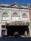 |
March 4, 1982 (#82003804) |
454 Northampton Street 40°41′29″N 75°12′45″W / 40.6914°N 75.2125°W | Easton | |
| 58 | Daniel Steckel House | 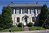 |
March 8, 1982 (#82003802) |
207 West Northampton Street 40°43′38″N 75°23′40″W / 40.7272°N 75.3944°W | Bath | |
| 59 | Isaac Stout House |  |
August 11, 2004 (#04000834) |
50 Durham Road 40°36′37″N 75°13′59″W / 40.6103°N 75.2331°W | Williams Township | |
| 60 | The Tannery |  |
June 19, 1972 (#72001143) |
Within Bethlehem Historic Subdistrict A near Monocacy Creek 40°37′11″N 75°23′02″W / 40.6197°N 75.3839°W | Bethlehem | |
| 61 | John Wagner and Family Farmstead |  |
July 23, 2020 (#100005357) |
1789 Meadows Rd. 40°34′07″N 75°20′50″W / 40.5686°N 75.3473°W | Lower Saucon Township | |
| 62 | Walnut Street Bridge |  |
May 8, 2023 (#100008901) |
200 feet (61 m) west of the intersection of Walnut St. and the Saucon Valley Rail Tr. 40°34′20″N 75°20′41″W / 40.5722°N 75.3448°W | Hellertown | |
| 63 | Weona Park Carousel |  |
August 4, 1999 (#99000879) |
Pennsylvania Route 512 40°52′15″N 75°14′55″W / 40.8708°N 75.2486°W | Pen Argyl | |
| 64 | Whitefield House and Gray Cottage |  |
May 1, 1980 (#80003589) |
214 East Center Street 40°44′28″N 75°18′28″W / 40.7411°N 75.3078°W | Nazareth | |
| 65 | Zeta Psi Fraternity House |  |
May 21, 2001 (#01000506) |
49 South College Drive 40°41′51″N 75°12′28″W / 40.6975°N 75.2078°W | Easton |
Former listing edit
| [2] | Name on the Register | Image | Date listed | Date removed | Location | Municipality | Description |
|---|---|---|---|---|---|---|---|
| 1 | Fountain Hill Opera House |  |
June 7, 1979 (#79002306) | August 11, 1987 | 405 Wyandotte Street | Bethlehem | Destroyed by arsonist on August 13, 1983.[4] |
See also edit
References edit
- ^ National Park Service, United States Department of the Interior, "National Register of Historic Places: Weekly List Actions", retrieved May 3, 2024.
- ^ a b Numbers represent an alphabetical ordering by significant words. Various colorings, defined here, differentiate National Historic Landmarks and historic districts from other NRHP buildings, structures, sites or objects.
- ^ The eight-digit number below each date is the number assigned to each location in the National Register Information System database, which can be viewed by clicking the number.
- ^ "Fire guts old Bethlehem theater". The Morning Call. August 14, 1983. p. 1. Retrieved August 20, 2022 – via Newspapers.com.
External links edit
Wikimedia Commons has media related to National Register of Historic Places in Northampton County, Pennsylvania.