
KNOWPIA
WELCOME TO KNOWPIA

National Register of Historic Places listings in Livingston Parish, Louisiana 
Summary
This is a list of the National Register of Historic Places listings in Livingston Parish, Louisiana.

This is intended to be a complete list of the properties on the National Register of Historic Places in Livingston Parish, Louisiana, United States. The locations of National Register properties for which the latitude and longitude coordinates are included below, may be seen in a map.[1]
There are 15 properties listed on the National Register in the parish.
This National Park Service list is complete through NPS recent listings posted April 12, 2024.[2]
Current listings edit
| [3] | Name on the Register | Image | Date listed[4] | Location | City or town | Description |
|---|---|---|---|---|---|---|
| 1 | Brown Hotel and Cafe | 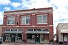 |
October 6, 2015 (#15000695) |
114 North Range Avenue 30°29′06″N 90°57′21″W / 30.484898°N 90.955954°W | Denham Springs | |
| 2 | Carter Plantation |  |
February 23, 1979 (#79001069) |
30325 Carter Cemetery Road 30°24′51″N 90°34′39″W / 30.41412°N 90.57747°W | Springfield vicinity | Built c. 1820 for free man of color Thomas Freeman. During the Civil War, a minor Confederate naval operation was launched here. |
| 3 | Castleberry Boarding House |  |
June 12, 2001 (#01000624) |
18290 Cooper Street 30°19′57″N 90°51′00″W / 30.33251°N 90.85001°W | Port Vincent | |
| 4 | Decareaux House | 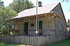 |
May 14, 1992 (#92000507) |
16021 LA 16 30°17′55″N 90°47′56″W / 30.29874°N 90.79901°W | French Settlement | Also known as the Creole House Museum |
| 5 | Denham Springs City Hall |  |
April 16, 1993 (#93000304) |
115 Mattie Street 30°29′08″N 90°57′24″W / 30.48545°N 90.95677°W | Denham Springs | |
| 6 | Denham Springs Commercial Historic District | November 5, 2018 (#100003075) |
100-239 N Range Ave. 30°29′07″N 90°57′22″W / 30.4854°N 90.9561°W | Denham Springs | ||
| 7 | Deslattes House |  |
November 13, 2003 (#03001139) |
15620 LA 16 30°17′38″N 90°47′40″W / 30.29402°N 90.79432°W | French Settlement | |
| 8 | Guitreau House | May 14, 1992 (#92000508) |
16825 LA 16 30°19′18″N 90°48′37″W / 30.32161°N 90.81019°W | French Settlement | ||
| 9 | Hungarian Settlement School |  |
August 2, 2001 (#01000805) |
27455 LA 43 30°28′04″N 90°34′40″W / 30.46788°N 90.57788°W | Albany vicinity | |
| 10 | Adam Lobell House | 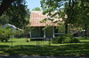 |
May 14, 1992 (#92000509) |
15715 LA 16 30°17′40″N 90°47′45″W / 30.2945°N 90.7959°W | French Settlement | |
| 11 | Macedonia Baptist Church |  |
June 6, 1980 (#80001738) |
Along LA 1036, about 7.4 miles (11.9 km) north of Holden 30°36′10″N 90°42′59″W / 30.6027°N 90.71625°W | Holden vicinity | Organized in 1856, the present vernacular-style building dates from 1898. |
| 12 | Old Livingston Parish Courthouse |  |
August 7, 1989 (#89001040) |
32283 2nd Street 30°25′42″N 90°32′45″W / 30.42843°N 90.54591°W | Springfield | Springfield was the seat of the Parish from 1835 to 1872. |
| 13 | St. Margaret Catholic Church |  |
January 28, 1992 (#91002025) |
30300 Catholic Hall Road 30°28′26″N 90°34′49″W / 30.474°N 90.58016°W | Albany vicinity | |
| 14 | Luther V. and Josie N. Settoon House |  |
September 27, 2022 (#100008254) |
32210 2nd St. 30°25′44″N 90°32′47″W / 30.4288°N 90.5464°W | Springfield | |
| 15 | Walker High School |  |
March 3, 2000 (#00000159) |
13443 Burgess Avenue 30°29′23″N 90°51′48″W / 30.48966°N 90.86329°W | Walker |
See also edit
Wikimedia Commons has media related to National Register of Historic Places in Livingston Parish, Louisiana.
References edit
- ^ The latitude and longitude information provided in this table was derived originally from the National Register Information System, which has been found to be fairly accurate for about 99% of listings. Some locations in this table may have been corrected to current GPS standards.
- ^ National Park Service, United States Department of the Interior, "National Register of Historic Places: Weekly List Actions", retrieved April 12, 2024.
- ^ Numbers represent an alphabetical ordering by significant words. Various colorings, defined here, differentiate National Historic Landmarks and historic districts from other NRHP buildings, structures, sites or objects.
- ^ The eight-digit number below each date is the number assigned to each location in the National Register Information System database, which can be viewed by clicking the number.