
KNOWPIA
WELCOME TO KNOWPIA

National Register of Historic Places listings in Lincoln County, Arkansas 
Summary
This is a list of the National Register of Historic Places listings in Lincoln County, Arkansas.

This is intended to be a complete list of the properties and districts on the National Register of Historic Places in Lincoln County, Arkansas, United States. The locations of National Register properties and districts for which the latitude and longitude coordinates are included below, may be seen in a map.[1]
There are 9 properties and districts listed on the National Register in the county, and one former listing.
This National Park Service list is complete through NPS recent listings posted May 10, 2024.[2]
Current listings edit
| [3] | Name on the Register[4] | Image | Date listed[5] | Location | City or town | Description |
|---|---|---|---|---|---|---|
| 1 | Crow House | June 29, 1976 (#76000426) |
7 miles southeast of Star City 33°54′00″N 91°50′58″W / 33.9000°N 91.8494°W | Star City | ||
| 2 | Oscar Crow House |  |
October 8, 1992 (#92001343) |
404 Washington St. 33°56′20″N 91°50′50″W / 33.938889°N 91.847222°W | Star City | |
| 3 | Cummins Prison Chapel | April 30, 2024 (#100010309) |
2540 Highway 388 34°03′12″N 91°35′03″W / 34.0533°N 91.5842°W | Grady | ||
| 4 | Lincoln County Courthouse |  |
March 7, 1994 (#94000141) |
300 S. Drew St. 33°56′22″N 91°50′40″W / 33.939444°N 91.844444°W | Star City | |
| 5 | Mt. Zion Presbyterian Church |  |
January 21, 1988 (#87002496) |
Highway 81 33°47′31″N 91°50′19″W / 33.791944°N 91.838611°W | Relfs Bluff | |
| 6 | Parker House | 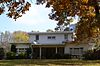 |
June 2, 2000 (#00000607) |
HC 64 Box 5 33°54′53″N 91°50′50″W / 33.914722°N 91.847222°W | Star City | |
| 7 | Rice Family Cemetery | 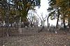 |
May 29, 2003 (#03000464) |
Junction of U.S. Route 65 and Highway 388 34°02′34″N 91°36′44″W / 34.042778°N 91.612222°W | Varner | |
| 8 | Star City Commercial Historic District |  |
February 26, 1999 (#99000152) |
Roughly along Jefferson and Bradley Sts. 33°56′30″N 91°50′44″W / 33.941667°N 91.845556°W | Star City | |
| 9 | Star City Confederate Memorial |  |
April 26, 1996 (#96000448) |
Southwestern corner of the Star City Town Sq. 33°56′30″N 91°50′45″W / 33.941667°N 91.845833°W | Star City |
Former listings edit
| [3] | Name on the Register | Image | Date listed | Date removed | Location | City or town | Description |
|---|---|---|---|---|---|---|---|
| 1 | Charles Hampton Tracy House | 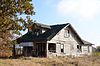 |
January 24, 2011 (#10001156) | January 4, 2021 | 2794 Blair Rd. 34°03′05″N 91°46′42″W / 34.051389°N 91.778333°W | Star City vicinity |
See also edit
Wikimedia Commons has media related to National Register of Historic Places in Lincoln County, Arkansas.
References edit
- ^ The latitude and longitude information provided in this table was derived originally from the National Register Information System, which has been found to be fairly accurate for about 99% of listings. Some locations in this table may have been corrected to current GPS standards.
- ^ National Park Service, United States Department of the Interior, "National Register of Historic Places: Weekly List Actions", retrieved May 10, 2024.
- ^ a b Numbers represent an alphabetical ordering by significant words. Various colorings, defined here, differentiate National Historic Landmarks and historic districts from other NRHP buildings, structures, sites or objects.
- ^ "National Register Information System". National Register of Historic Places. National Park Service. March 13, 2009.
- ^ The eight-digit number below each date is the number assigned to each location in the National Register Information System database, which can be viewed by clicking the number.