


Summary
Meeanee is a locality south of the city of Napier, in the Hawke's Bay Region on the east coast of New Zealand's North Island. It was named after the Battle of Meeanee in India (now spelled Miani, but the area has retained the older spelling), won by Sir Charles Napier, the city's namesake.[1] Along with such locations as Clive and Havelock North, it is one of several places within Hawke's Bay to be named after events or people in Colonial India.
Meeanee | |
|---|---|
Suburb of Napier | |
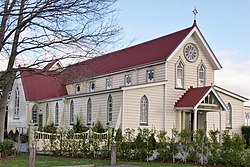 St. Mary's Church, Meeanee. | |
 | |
| Coordinates: 39°32′38″S 176°53′35″E / 39.544°S 176.893°E | |
| Country | New Zealand |
| Region | Hawke's Bay |
| Territorial authority | Napier City |
| Ward | Taradale |
| Named for | Battle of Meeanee[1] |
| Electorates | |
| Government | |
| • Territorial Authority | Napier City Council |
| • Regional council | Hawke's Bay Regional Council |
| Area | |
| • Total | 24.17 km2 (9.33 sq mi) |
| Elevation | 0–3 m (0–10 ft) |
| Population (June 2023)[3] | |
| • Total | 3,310 |
| • Density | 140/km2 (350/sq mi) |
| Time zone | UTC+12 (NZST) |
| • Summer (DST) | UTC+13 (NZDT) |
| Postcode | 4112 |
| Area Code | 06 |
History edit
Meeanee was the only access inland to Taradale until the road was built in 1873, and was the site of a Catholic Marist mission station from the 1850s.[4] The priests introduced viticulture to the Hawke's Bay region, planting several vineyards and establishing the Mission Estate Winery in 1851, New Zealand's oldest surviving winemaking concern.[5] They also built St Mary's Church in 1863, which still stands but is now a privately owned restaurant and event venue.[6]
Economy edit
Meeanee is located on the flat coastal plain south of Napier, and surrounded by farmland and apple orchards.
Demographics edit
The statistical area of Meeanee-Awatoto, which includes Awatoto, covers 24.17 km2 (9.33 sq mi)[2] and had an estimated population of 3,310 as of June 2023,[3] with a population density of 137 people per km2.
| Year | Pop. | ±% p.a. |
|---|---|---|
| 2006 | 1,494 | — |
| 2013 | 1,932 | +3.74% |
| 2018 | 2,541 | +5.63% |
| Source: [7] | ||

Meeanee-Awatoto had a population of 2,541 at the 2018 New Zealand census, an increase of 609 people (31.5%) since the 2013 census, and an increase of 1,047 people (70.1%) since the 2006 census. There were 891 households, comprising 1,293 males and 1,248 females, giving a sex ratio of 1.04 males per female. The median age was 43.7 years (compared with 37.4 years nationally), with 471 people (18.5%) aged under 15 years, 399 (15.7%) aged 15 to 29, 1,221 (48.1%) aged 30 to 64, and 444 (17.5%) aged 65 or older.
Ethnicities were 87.5% European/Pākehā, 14.4% Māori, 3.1% Pacific peoples, 4.5% Asian, and 2.6% other ethnicities. People may identify with more than one ethnicity.
The percentage of people born overseas was 15.0, compared with 27.1% nationally.
Although some people chose not to answer the census's question about religious affiliation, 53.4% had no religion, 35.3% were Christian, 0.8% had Māori religious beliefs, 0.5% were Hindu, 0.1% were Muslim, 0.2% were Buddhist and 2.6% had other religions.
Of those at least 15 years old, 381 (18.4%) people had a bachelor's or higher degree, and 327 (15.8%) people had no formal qualifications. The median income was $37,400, compared with $31,800 nationally. 426 people (20.6%) earned over $70,000 compared to 17.2% nationally. The employment status of those at least 15 was that 1,137 (54.9%) people were employed full-time, 309 (14.9%) were part-time, and 60 (2.9%) were unemployed.[7]
Education edit
Meeanee School is a co-educational Year 1-8 state primary school,[8] with a roll of 103 as of February 2024.[9][10] The school opened in 1865.[11]
References edit
- ^ a b "St Thomas' Anglican Church". Heritage New Zealand. Retrieved 8 December 2019.
- ^ a b "ArcGIS Web Application". statsnz.maps.arcgis.com. Retrieved 13 January 2024.
- ^ a b "Population estimate tables - NZ.Stat". Statistics New Zealand. Retrieved 25 October 2023.
- ^ Pollock, Kerryn. "Catholic mission station, Meeanee, 1850s". Te Ara - The Encyclopedia of New Zealand. Ministry for Culture and Heritage. Retrieved 8 December 2019.
- ^ Dalley, Bronwyn (24 November 2008). "Wine – Page 1. 19th-century origins". Te Ara - The Encyclopedia of New Zealand. Ministry for Culture and Heritage. Retrieved 8 December 2019.
- ^ "St Mary's Church". Heritage New Zealand. Retrieved 8 December 2019.
- ^ a b "Statistical area 1 dataset for 2018 Census". Statistics New Zealand. March 2020. Meeanee-Awatoto (215400). 2018 Census place summary: Meeanee-Awatoto
- ^ "Meeanee School Ministry of Education School Profile". educationcounts.govt.nz. Ministry of Education.
- ^ "New Zealand Schools Directory". New Zealand Ministry of Education. Retrieved 14 March 2024.
- ^ "Meeanee School Education Review Office Report". ero.govt.nz. Education Review Office.
- ^ "Meeanee School 130th jubilee : 20, 21 & 22 October : 1865 - 1995". Auckland Museum. Retrieved 24 February 2023.