
KNOWPIA
WELCOME TO KNOWPIA

Leeuwarderadeel 
Summary
Leeuwarderadeel (Dutch: [leːˈʋɑrdəraːˌdeːl] ⓘ; West Frisian: Ljouwerteradiel) is a former municipality in the northern Netherlands. Its capital was Stiens.
Leeuwarderadeel
Ljouwerteradiel | |
|---|---|
 Wind mill in Leeuwarderadeel | |
 Flag  Coat of arms | |
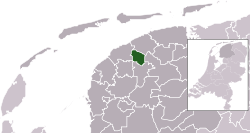 Location in Friesland | |
| Coordinates: 53°16′N 5°46′E / 53.267°N 5.767°E | |
| Country | Netherlands |
| Province | Friesland |
| Merged | 2018 |
| Area | |
| • Total | 41.46 km2 (16.01 sq mi) |
| • Land | 40.91 km2 (15.80 sq mi) |
| • Water | 0.55 km2 (0.21 sq mi) |
| Elevation | 1 m (3 ft) |
| Highest elevation | 1.7 m (5.6 ft) |
| Lowest elevation | 0.6 m (2.0 ft) |
| Population (January 2021)[3] | |
| • Total | data missing |
| Time zone | UTC+1 (CET) |
| • Summer (DST) | UTC+2 (CEST) |
| Postcode | 9050–9057 9071–9072 |
| Area code | 0518, 058 |
| Website | www |
History edit
On 1 January 2018 it merged with the municipality of Leeuwarden.
Population centres edit
Topography edit

Dutch Topographic map of the municipality of Leeuwarderadeel, June 2015.
Bartlehiem edit
The hamlet of Bartlehiem is partially in Leeuwarderadeel partially in Ferwerderadiel and partially in Tytsjerksteradiel.
References edit
- ^ "Kerncijfers wijken en buurten 2020" [Key figures for neighbourhoods 2020]. StatLine (in Dutch). CBS. 24 July 2020. Retrieved 19 September 2020.
- ^ "Postcodetool for 9051AR". Actueel Hoogtebestand Nederland (in Dutch). Het Waterschapshuis. Retrieved 19 September 2013.
- ^ "Bevolkingsontwikkeling; regio per maand" [Population growth; regions per month]. CBS Statline (in Dutch). CBS. 1 January 2021. Retrieved 2 January 2022.
External links edit
 Media related to Leeuwarderadeel at Wikimedia Commons
- Official website