


Summary
The Dinira National Park[1][2] (Spanish: Parque nacional Dinira)[3] is a protected area with the national park status located between the states Lara, Portuguesa and Trujillo in the South American country of Venezuela.[4] It was created on November 30, 1988.
| Dinira National Park Parque Nacional Dinira | |
|---|---|
 | |
 Location | |
| Location | |
| Coordinates | 9°25′N 70°10′W / 9.417°N 70.167°W |
| Area | 453.28 km2 (175.01 sq mi) |
| Established | November 30, 1988 |
It was created in order to protect the upper basin of the Tocuyo River. In total there are five basins, Orinoco, Guanare, Motatán, and Lake Maracaibo, including the Tocuyo River.
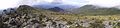
It has an area of 45,328 hectares of mountainous relief in whose entrails are born in addition to the river Tocuyo, numerous streams of water of regional importance. This motivated the natives who populated it to call it Dinira, because its waters feed other currents below. It can rain up to 1,300 mm annually.
Gallery edit
-
 Cascada del Vino
 -
 Lagoon
 -
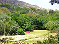 Camping
 -
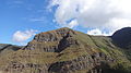 Humocaro Mountains
 -
 Los Nepes


See also edit
References edit
- ^ Parque Nacional Dinira - ParksWatch
- ^ Cunill, Pedro (1990-01-01). Venezuela: opciones geográficas (in Spanish). Fundación Eugenio Mendoza. ISBN 9789806017481.
- ^ Boyla, Kerem; Estrada, Angélica; International, BirdLife (2017-03-15). Áreas importantes para la conservación de las aves en los Andes tropicales: sitios prioritarios para la conservación de la biodiversidad (in Spanish). BirdLife International. ISBN 9789978441961.
- ^ Venezuela tierra mágica: Dinira: parque nacional, Estado Trujillo (in Spanish). Corpoven. 1999-01-01.