


Summary
Blue Pool Road is a road linking Happy Valley and Wong Nai Chung Gap on Hong Kong Island, Hong Kong.
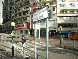 Lower section of Blue Pool Road, near its intersection with Wong Nai Chung Road in July 2006. | |
| Native name | 藍塘道 (Chinese) |
|---|---|
| Length | 1.5 km (0.93 mi) |
| Blue Pool Road | |||||||||||
|---|---|---|---|---|---|---|---|---|---|---|---|
| Traditional Chinese | 藍塘道 | ||||||||||
| Simplified Chinese | 蓝塘道 | ||||||||||
| |||||||||||


Location edit
Blue Pool Road is divided into two sections. The first and longest section starts at Wong Nai Chung Road, opposite the southeastern part of Happy Valley Racecourse and continues uphill, until a roundabout at Tai Hang Road. The second section starts Tai Hang Road and continues uphill and ends in a dead end.
History edit
The road was previously occupied by Wong Nai Chung Village (黃泥涌村), which was settled by the Ngs (吳) and Yips (葉), both Hakkas from the Mainland,[1] before British Colonization on Hong Kong Island. It was located part-way up the slope that Blue Pool Road follows today and below today's Village Road.[2] Wong Nai Chung Village was replaced with residential buildings in the 1920s, as a consequence of urban development.[1]
The street is named after the former "Blue Pool", a natural feature[3] near the former Wong Nai Chung Village, in which people could bathe until around World War I. The Pool was fed by the Wong Nai Chung river, which then flowed into Victoria Harbour.[2]
During the Battle of Hong Kong, troops of the Hong Kong Volunteer Defence Corps took part in the battle for Wong Nai Chung Gap on 18–20 December 1941, and held several positions, including at Blue Pool Road.[4][5] On 22 December 1941, a massacre of Chinese civilians by Japanese troops occurred at Blue Pool Road.[6][7][8][9][10][11] About 30 civilians were killed at Blue Pool Road during the Battle of Hong Kong.[4]
Features edit
Blue Pool Road has several steep slopes. It is mainly lined with residential apartments, although there are a number of shops and the odd boutique hotel along the road. Several schools are located in the upper part of the street.
- First section
- No. 9: a temple complex occupies a small hill at the intersection with Ventris Road. It is the site of a Tam Kung Temple and a Tin Hau Temple. The Tam Kung Temple was built in 1901 after the previous one located on a slope near the Hong Kong Sanatorium and Hospital in Happy Valley, in the former Wong Nai Chung Village,[1] was demolished during urban development. According to a story, Tam Kung appeared to a young boy in a dream and guided him to the present site, which was regarded as selected by the deity for the new location of the temple.[2] A Tin Hau Temple, also relocated in 1901,[12] is situated at the back of this temple.[13] The temples have been managed by the Chinese Temples Committee since 1929.[1]
- No. 60: building housing the UNICEF Hong Kong head office[14] and the administrative office of the Hong Kong Ballet.[15]
- Nos.118 and 120: two semi-detached houses which form one building. The plot was acquired in 1937 by Eu Tong-sen (余東旋), the founder of Eu Yan Sang, who built a number of apartment houses along Blue Pool Road and Broom Road. The three-storey apartment block was built in the International Modern style of the 1930s.[16] The building was listed as a Grade III historic building in January 2010.[17]
- No. 123: Marymount Secondary School, a Catholic girls' school. The school moved to this location in October 1957.
- Second section
- No. 157: Hong Kong Japanese School (primary section). Opened in 1976.[8]
- No. 165: Lycée Français International Victor Segalen (French International School), secondary section[18]
Transport edit
The lower end of Blue Pool Road is located near the Hong Kong Tramways Happy Valley terminus. Bus routes 1, 1P and 19 also service on the upper end of Blue Pool Road.
See also edit
References edit
- ^ a b c d Brief Information on No Grade Items Archived 17 October 2012 at the Wayback Machine. Items #1404 and #1413.
- ^ a b c Wordie, Jason (2002). Streets: Exploring Hong Kong Island. Hong Kong: Hong Kong University Press. pp. 146–149. ISBN 962-209-563-1.
- ^ Rodrigues, Albert (1998). "Chapter: A Hong Kong Doctor in War and Peace". In Matthews, Clifford; Cheung, Oswald (eds.). Dispersal and Renewal: Hong Kong University During the War Years. Hong Kong University Press. p. 203. ISBN 978-962-209-472-7.
- ^ a b Banham, Tony (2004). Not the slightest chance: the defence of Hong Kong, 1941. University of British Columbia Press. pp. 115 & 307. ISBN 978-0-7748-1045-6.
- ^ Luff, John (1967). The hidden years. Hong Kong. p. 77. ASIN B0006CQ0FQ.
{{cite book}}:|work=ignored (help)CS1 maint: location missing publisher (link) - ^ Christina Ching Tsao (2005). Shanghai Bride: Her Tumultuous Life's Journey to the West. Hong Kong University Press. p. 152. ISBN 978-962-209-714-8.
- ^ Appendices: Excerpts from War-Crime Trials. Appendix 7
- ^ a b Poy, Vivienne (2006). Profit, Victory & Sharpness: The Lees of Hong Kong. Hong Kong University Press. pp. 110& 217. ISBN 978-0-9736820-1-4.
- ^ Harrop, Phyllis (1943). Hong Kong Incident. London: Eyre & Spottiswoode. pp. 83–84.
- ^ Liu, Shuyong (1997). An outline history of Hong Kong. Foreign Languages Press. p. 109. ISBN 978-7-119-01946-8.
- ^ Chamberlain, Jonathan (2007). "Chapter: How Mr Tai and Mr Tang were both saved by a piece of jade". King Hui: The Man Who Owned All the Opium in Hong Kong. Blacksmith Books. p. 209. ISBN 978-988-99799-8-0.
- ^ Introduction to 1444 Historic Buildings Archived 13 October 2012 at the Wayback Machine. Items #1404 and #1413.
- ^ Chinese Temples Committee – Tam Kung Tin Hau Temple, Wong Nai Chung Archived 4 October 2011 at the Wayback Machine
- ^ UNICEF Hong Kong: Contact Us
- ^ Hong Kong ballet website: Contact Us
- ^ Brief Information on Proposed Grade III Items Archived 17 October 2012 at the Wayback Machine. Items No. 605 and #606.
- ^ List of 1,444 historic buildings with assessment results Archived 15 December 2011 at the Wayback Machine
- ^ Lycée Français International de Hong Kong: Sites – Blue Pool Road
External links edit
- Google Maps of Blue Pool Road
- Some details about Blue Pool Road air-raid shelter
22°16′05″N 114°11′16″E / 22.268109°N 114.187689°E