


Summary
The 33rd parallel north is a circle of latitude that is 33 degrees north of the Earth's equatorial plane. It is approximate at the midpoint between the equator (0 degrees) and the Arctic Circle (66.6 degrees North Latitude.) It crosses North Africa, Asia, the Pacific Ocean, North America and the Atlantic Ocean.

In Iraq, the parallel defined the limit of the southern no-fly zone from 4 September 1996 to 30 August 2003. (Before this time, it had been set at the 32nd parallel north) as part of Operation Southern Watch.[1]
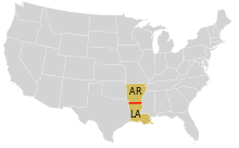
In the United States, it approximately forms the border between Arkansas in the north and Louisiana on the south. (The border is actually a couple of kilometres north of the parallel.) The Louisiana Territory was that part of the 1803 Louisiana Purchase which lay north of the 33rd parallel.
The parallel is part of the horse latitudes.
At this latitude the sun is visible for 14 hours, 20 minutes during the summer solstice and 9 hours, 58 minutes during the winter solstice.[2]
Around the world edit
Starting at the prime meridian and heading eastwards, the parallel 33° north passes through:
Co-ordinates Country, territory or sea Notes 33°0′N 0°0′E / 33.000°N 0.000°E  Algeria
33°0′N 8°11′E / 33.000°N 8.183°E  Tunisia
33°0′N 11°31′E / 33.000°N 11.517°E  Libya
Libya
33°0′N 12°0′E / 33.000°N 12.000°E Mediterranean Sea Passing just north of Tripoli, Libya
33°0′N 35°5′E / 33.000°N 35.083°E  Israel
Passing through Nahariya and Amuka 33°0′N 35°38′E / 33.000°N 35.633°E Golan Heights Territory controlled by Israel, claimed by  Syria – passing through the northern edge of Katzrin
33°0′N 35°52′E / 33.000°N 35.867°E UNDOF buffer zone About 500 m (1,640 ft) 33°0′N 35°53′E / 33.000°N 35.883°E Syria
33°0′N 38°5′E / 33.000°N 38.083°E  Jordan
33°0′N 39°3′E / 33.000°N 39.050°E  Iraq
Iraq
Passing just south of Baghdad 33°0′N 46°6′E / 33.000°N 46.100°E  Iran
Iran
33°0′N 60°38′E / 33.000°N 60.633°E  Afghanistan
33°0′N 69°30′E / 33.000°N 69.500°E  Pakistan
Khyber Pakhtunkhwa Punjab
Azad Kashmir – claimed by India
India
33°0′N 74°21′E / 33.000°N 74.350°E India
Jammu and Kashmir – claimed by Pakistan
Ladakh – claimed by Pakistan
Himachal Pradesh33°0′N 79°14′E / 33.000°N 79.233°E Aksai Chin Disputed between India and  People's Republic of China
33°0′N 79°21′E / 33.000°N 79.350°E People's Republic of China
Tibet
Qinghai
Sichuan
Qinghai
Sichuan
Gansu
Shaanxi
Hubei
Henan
Anhui
Jiangsu
Anhui (for about 12 km (7.5 mi))
Jiangsu33°0′N 126°16′E / 33.000°N 126.267°E Korea South Sea Passing just south of the island of Marado,  South Korea
33°0′N 129°2′E / 33.000°N 129.033°E  Japan
Japan
Island of Nakadōri:
— Nagasaki Prefecture
Island of Kyūshū:
— Nagasaki Prefecture
— Saga Prefecture
— Kumamoto Prefecture
— Ōita Prefecture
Island of Shikoku:
— Ehime Prefecture
— Kōchi Prefecture33°0′N 133°1′E / 33.000°N 133.017°E Pacific Ocean 33°0′N 118°35′W / 33.000°N 118.583°W  United States
California – Northern tip of San Clemente Island 33°0′N 118°33′W / 33.000°N 118.550°W Pacific Ocean 33°0′N 117°17′W / 33.000°N 117.283°W United States
California – passing through Solana Beach and just north of Brawley
Arizona – passing through Casa Grande Ruins National Monument
New Mexico
Texas – passing through the Dallas–Fort Worth metroplex
Louisiana – passing just south of the border with Arkansas
Mississippi
Alabama
Georgia – passing through LaGrange, and Louisville
South Carolina – passing through Goose Creek33°0′N 79°28′W / 33.000°N 79.467°W Atlantic Ocean 33°0′N 16°23′W / 33.000°N 16.383°W  Portugal
Cal Islet, just south of Porto Santo Island, Madeira 33°0′N 16°22′W / 33.000°N 16.367°W Atlantic Ocean 33°0′N 8°45′W / 33.000°N 8.750°W  Morocco
Passing through Settat 33°0′N 1°28′W / 33.000°N 1.467°W Algeria