


Summary
Zuunmod (Mongolian: Зуунмод; ᠵᠠᠭᠤᠨᠮᠣᠳᠤ, "Hundred Trees") is the administrative seat of Mongolia's Töv Province. It has a population of 16,953 (2017) inhabitants and an area of 19.18 square kilometres.[1] Zuunmod is located on the south side of Bogd Khan Mountain, 43 kilometres (27 mi) south of the capital city of Ulaanbaatar. Zuunmod was established as the administrative center of Töv Province in 1942. Until that time, the administration of the aimag had been located in Ulaanbaatar.
Zuunmod District
Зуунмод сум ᠵᠠᠭᠤᠨᠮᠣᠳᠤᠰᠤᠮᠤ | |
|---|---|
 Zuunmod centre | |
 Zuunmod District | |
| Coordinates: 47°42′25″N 106°56′58″E / 47.70694°N 106.94944°E | |
| Country | Mongolia |
| Province | Töv Province |
| Area | |
| • Total | 19.18 km2 (7.41 sq mi) |
| Elevation | 1,530 m (5,020 ft) |
| Population (2017) | |
| • Total | 16,953 |
| • Density | 880/km2 (2,300/sq mi) |
| Time zone | UTC+8 (UTC + 8) |
| Area code | +976 (0) 272 |
The significant Battle of Jao Modo took place here in early May 1649, ending with the victory for the Qing dynasty.
Livestock edit
In 2004, Zuunmod officially had roughly 24,000 head of livestock, among them 8,500 goats, 12,000 sheep, 2,000 cattle, about as many horses, and no camels.[2]
Climate edit
Zuunmod has a dry-winter subarctic climate (Köppen Dwc).
| Climate data for Zuunmod, 1981–2010 | |||||||||||||
|---|---|---|---|---|---|---|---|---|---|---|---|---|---|
| Month | Jan | Feb | Mar | Apr | May | Jun | Jul | Aug | Sep | Oct | Nov | Dec | Year |
| Mean daily maximum °C (°F) | −14.2 (6.4) |
−10.3 (13.5) |
−2.5 (27.5) |
7.9 (46.2) |
16.1 (61.0) |
21.0 (69.8) |
22.9 (73.2) |
20.7 (69.3) |
15.1 (59.2) |
6.0 (42.8) |
−5.2 (22.6) |
−11.9 (10.6) |
5.5 (41.8) |
| Mean daily minimum °C (°F) | −24.9 (−12.8) |
−21.8 (−7.2) |
−14.4 (6.1) |
−5.4 (22.3) |
2.2 (36.0) |
8.2 (46.8) |
11.3 (52.3) |
9.2 (48.6) |
2.4 (36.3) |
−5.8 (21.6) |
−15.9 (3.4) |
−22.4 (−8.3) |
−6.4 (20.4) |
| Average precipitation mm (inches) | 2.5 (0.10) |
2.5 (0.10) |
4.4 (0.17) |
7.0 (0.28) |
18.9 (0.74) |
49.0 (1.93) |
73.4 (2.89) |
74.3 (2.93) |
26.1 (1.03) |
9.4 (0.37) |
5.7 (0.22) |
2.8 (0.11) |
276 (10.87) |
| Average precipitation days | 6.0 | 6.0 | 8.2 | 8.6 | 8.6 | 13.9 | 17.0 | 15.3 | 8.7 | 7.1 | 8.2 | 7.6 | 115.2 |
| Source: World Meteorological Organization[3] | |||||||||||||
Notable residents edit
- Ganzorigiin Mandakhnaran - Mongolian wrestler
Gallery edit
-
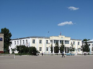 Zuunmod Town Hall
 -
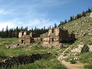 Togchin Temple ruins
 -
 Zuunmod church


References edit
- Төв аймаг - Зуунмод[permanent dead link]
- ^ "Төв аймгийн төв Зуунмод хот нь 1918 га газартай": Töv aimag official site[permanent dead link]
- ^ National Statistical Office: Livestock count 2004 (in Mongolian), p.109 Archived June 15, 2007, at the Wayback Machine
- ^ "World Weather Information Service – Zuunmod". World Meteorological Organization. Retrieved November 12, 2022.
47°42′25″N 106°56′58″E / 47.70694°N 106.94944°E