


Summary
Valdes Island[1] is one of the Gulf Islands located in the Strait of Georgia, British Columbia, Canada. It is across Porlier Pass from Galiano Island, which lies to the southeast. It has an area of 23 square kilometres (9 square miles), and is 1.6 kilometres (1.0 mile) wide by 16 kilometres (9.9 miles) in length. The island is popular with kayakers, boaters and has historically been the site of several human settlements.
Valdes Island | |
|---|---|
Island | |
 A kayak and a sunset on Valdes Island. | |
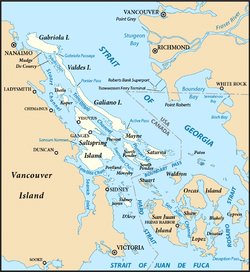 The Southern Gulf Islands, including Valdes. | |
| Country | Canada |
| Province | British Columbia |
| Land district | Cedar Land District |
| Region | Southern Gulf Islands |
| Government | |
| • MP | Lisa Marie Barron (NDP) |
| • MLA | Doug Routley (BC NDP) |
| Area | |
| • Total | 23 km2 (9 sq mi) |
| Population (2016) | |
| • Total | 10 |
| Population for Dissemination Block 59190308003 | |
| Time zone | UTC−8 (PST) |
| • Summer (DST) | UTC−7 (PDT) |
| Area code(s) | 250, 778 |
Naming and early exploration edit
It is named for Spanish explorer Cayetano Valdés y Flores, who first came to the region in 1791[2] as a lieutenant serving under Captain Alessandro Malaspina on the Descubierta. Valdes returned later in 1792 as captain of the Mexicana to explore the area with Dionisio Alcalá Galiano who captained the Sutil.[3] The island was given its name in 1859 by George Henry Richards, captain of HMS Plumper.[4]
Settlement edit
Currently there are few permanent residents on Valdes Island. One third of the island is set aside as three Indian reserves of the Lyackson First Nation.[5][6][7][8] At Shingle Point, which is the location of one of those reserves, the island shows evidence of human habitation from at least 5,000 years ago in the form of approximately 60 archeological sites.[3]
Brother XII edit
Valdes Island was one of the locations of the colonies of the Aquarian Foundation, the BC-based cult run by Brother XII in the late 1920s and early 1930s The organization had several buildings on the island, of which little trace remains today. There were also rumours that money was buried on the island, but these have never been proven.

Cave edit
There is a cave in the middle of the island. According to legend, it runs under the sea to emerge on Thetis Island, but recent explorers have found that rockfalls have made remote parts too narrow for human passage.

Recreational activities edit
Wakes Cove Provincial Park and the Blackberry Point Campsite are located on the island. These two campsites, as well as an abundance of wildlife and unusual sandstone geology make this island a popular destination for recreational kayaking and camping. The Blackberry Point Campsite was the first campsite established as part of the BC Marine Trails Network by Peter McGee in the early 1990s.[9] The site at Wakes Cove is still undeveloped, lacking any facilities for campers, however there is an abandoned well along an overgrown road in the area. The Blackberry Point site has defined cooking and tenting spaces, trails from the beach as well as a composting toilet.
Killer whales are abundant around the island.
References edit
- ^ "Valdes Island". BC Geographical Names.
- ^ Walbran, Captain John T. (1971). British Columbia Place Names, Their Origin and History (Facsimile reprint of 1909 ed.). Vancouver/Toronto: Douglas & McIntyre. ISBN 0-88894-143-9. Archived from the original on March 3, 2016. Retrieved July 6, 2014.
- ^ a b "Valdes Island, British Columbia, Canada". www.vancouverisland.com. Archived from the original on March 19, 2006.
- ^ Walbran, John T. (1909). British Columbia Coast Names, 1592–1906 : to which are added a few names in adjacent United States territory, their origin and history. Ottawa Government Printing Bureau. p. 501. OCLC 317633225. Archived from the original on March 7, 2012. Retrieved October 24, 2012.
- ^ "Lyacksun Indian Reserve 3". BC Geographical Names.
- ^ "Porlier Pass Indian Reserve 5". BC Geographical Names.
- ^ "Shingle Point Indian Reserve 4". BC Geographical Names.
- ^ "Indian and Northern Affairs Canada – Reserves/Settlements/Villages Detail". Crown–Indigenous Relations and Northern Affairs Canada. Government of Canada. November 14, 2008. Retrieved March 26, 2010.
- ^ "BC Marine Trails: Paddling Vancouver Island, Gulf Islands, Broken Group, Johnstone Strait, Haida Gwaii, North and South Coast - BC Marine Trails Network: Connecting the BC coast".
External links edit
- Land-use map of Valdes Island, Lyackson First Nation Archived 2011-07-06 at the Wayback Machine
49°05′N 123°40′W / 49.083°N 123.667°W