


Summary
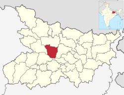
Vaishali district is a district of Mithila region in the Indian state of Bihar. It is a part of Tirhut division.[4] Vaishali is known for being the birthplace of Mahavira of the Jain religion. Hajipur, its largest city and district headquarters, is known for its banana forest. The district is connected via the NH-77 and NH-322 highways, which connect the state capital Patna, the division headquarters Muzaffarpur, and the eastward district Samastipur.
Vaishali district | |
|---|---|
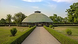 Relic Stupa in Vaishali | |
 | |
| Country | |
| State | Bihar |
| Division | Tirhut |
| Established | 10 December 1972 |
| Headquarters | Hajipur[1] |
| Government | |
| • Educationist | Shri Rajdeo Ray |
| • Lok Sabha constituencies | Hajipur, Vaishali |
| • Vidhan Sabha constituencies | Hajipur, Lalganj, Vaishali, Mahua, Raja Pakar, Raghopur, Mahnar, Patepur |
| Area | |
| • Total | 2,036 km2 (786 sq mi) |
| Elevation | 51 m (167 ft) |
| Population (2011) | |
| • Total | 3,495,021 |
| • Density | 1,700/km2 (4,400/sq mi) |
| Demographics | |
| • Literacy | 66.60% |
| • Sex ratio | 1.895 ♂/♀ |
| Language | |
| • Official | Hindi |
| • Additional official | Urdu |
| • Regional Languages | Maithili |
| Time zone | UTC+05:30 (IST) |
| PIN | 8441xx (Vaishali)[2] |
| Major highways | NH 22, NH 31, NH 322 |
| HDI (2016) | |
| Website | Official website |
History edit
Ancient Vaishali edit
According to legend, Vaishali derives its name from King Vishala, a son of Ikshvaku who founded the city. Vaishali was the capital of the vibrant Licchavi republic and was closely associated with the early histories of both Buddhism and Jainism.[5] In that period, Vaishali was an ancient metropolis and the capital city of the republic of the Vajji confederation of Mithila, which covered most of the Himalayan Gangetic region of present-day Bihar. Magadha rulers of the Shishunaga dynasty shifted its capital from Pataliputra to Vaishali.
Post-Independence edit
Vaishali became a district when it was split from Muzaffarpur in 1972.[6]
Geography edit
The Vaishali district occupies an area of 2,036 square kilometres (786 sq mi),[7]
Economy edit
In 2006 the Ministry of Panchayati Raj named Vaishali one of the country's 250 most backward districts (out of a total of 640).[8] It is one of the 38 districts in Bihar currently receiving funds from the Backward Regions Grant Fund Programme (BRGF).[8]
Demographics edit
| Year | Pop. | ±% p.a. |
|---|---|---|
| 1901 | 737,793 | — |
| 1911 | 761,720 | +0.32% |
| 1921 | 737,475 | −0.32% |
| 1931 | 787,287 | +0.66% |
| 1941 | 868,565 | +0.99% |
| 1951 | 942,472 | +0.82% |
| 1961 | 1,133,086 | +1.86% |
| 1971 | 1,348,990 | +1.76% |
| 1981 | 1,662,527 | +2.11% |
| 1991 | 2,146,065 | +2.59% |
| 2001 | 2,718,421 | +2.39% |
| 2011 | 3,495,021 | +2.54% |
| source:[9] | ||
According to the 2011 census Vaishali district has a population of 3,495,021,[11] roughly equal to the nation of Panama[12] or the US state of Connecticut.[13] This gives it a ranking of 86th in India (out of a total of 640).[11] The district has a population density of 1,717 inhabitants per square kilometre (4,450/sq mi) .[11] Its population growth rate over the decade 2001-2011 was 28.58%.[11] Vaishali has a sex ratio of 892 females for every 1000 males,[11] and a literacy rate of 66.60%. 6.67% of the population lives in urban areas. Scheduled Castes and Scheduled Tribes make up 21.12% and 0.07% of the population respectively.[11]
Languages edit
At the time of the 2011 Census of India, 95.09% of the population in the district spoke Hindi and 4.80% Urdu as their first language. 69.88% of the population recorded their language as 'Other' under Hindi, while Hindi itself was only reported by 25.10%. The dialect of the region is Bajjika, variously regarded as a dialect of Maithili language.[14]
Flora and fauna edit
In 1997, the district became home to the Barela Salim Ali Zubba Saheni Wildlife Sanctuary, which has an area of 2 km2 (0.8 sq mi).[15]
Politics edit
| District | No. | Constituency | Name | Party | Alliance | Remarks | ||
|---|---|---|---|---|---|---|---|---|
| Vaishali | 123 | Hajipur | Awadhesh Singh | BJP | NDA | |||
| 124 | Lalganj | Sanjay Kumar Singh | BJP | NDA | ||||
| 125 | Vaishali | Siddharth Patel | JD(U) | NDA | ||||
| 126 | Mahua | Mukesh Raushan Yadav | RJD | MGB | ||||
| 127 | Raja Pakar | Pratima Kumari | INC | MGB | ||||
| 128 | Raghopur | Tejashwi Yadav | RJD | MGB | ||||
| 129 | Mahnar | Bina Singh | RJD | MGB | ||||
| 130 | Patepur | Lakhendra Kumar Raushan | BJP | NDA | ||||
See also edit
References edit
- ^ "District headquarter of Vaishali". Archived from the original on 17 May 2021. Retrieved 3 June 2021. vaishali.nic.in
- ^ Vaishali
- ^ "Development of Human Development Index at District Level for EAG States" (PDF). March 2016. Archived (PDF) from the original on 2 June 2021. Retrieved 31 May 2021.
- ^ Official website of Tirhut Division Archived 2015-03-16 at the Wayback Machine
- ^ "Vaisali -- Britannica Online Encyclopedia". Archived from the original on 14 April 2022. Retrieved 31 October 2022.
- ^ Law, Gwillim (25 September 2011). "Districts of India". Statoids. Archived from the original on 17 October 2011. Retrieved 11 October 2011.
- ^ Dayawanti Srivastava, ed. (2010). "States and Union Territories: Bihar: Government". India 2010: A Reference Annual (54th ed.). New Delhi, India: Additional Director General, Publications Division, Ministry of Information and Broadcasting (India), Government of India. pp. 1118–1119. ISBN 978-81-230-1617-7.
- ^ a b Ministry of Panchayati Raj (8 September 2009). "A Note on the Backward Regions Grant Fund Programme" (PDF). National Institute of Rural Development. Archived from the original (PDF) on 5 April 2012. Retrieved 27 September 2011.
- ^ "Table A-02 Decadal Variation in Population Since 1901: Bihar" (PDF). census.gov.in. Registrar General and Census Commissioner of India.
- ^ "Table C-01 Population by Religion: Bihar". censusindia.gov.in. Registrar General and Census Commissioner of India. 2011.
- ^ a b c d e f "District Census Handbook: Vaishali" (PDF). Census of India. Registrar General and Census Commissioner of India. 2011.
- ^ US Directorate of Intelligence. "Country Comparison:Population". Archived from the original on 27 September 2011. Retrieved 1 October 2011.
Panama 3,460,462 July 2011 est.
- ^ "2010 Resident Population Data". U. S. Census Bureau. Archived from the original on 19 October 2013. Retrieved 30 September 2011.
Connecticut 3,574,097
- ^ a b "Table C-16 Population by Mother Tongue: Bihar". censusindia.gov.in. Registrar General and Census Commissioner of India. 2011.
- ^ Indian Ministry of Forests and Environment. "Protected areas: Bihar". Archived from the original on 23 August 2011. Retrieved 25 September 2011.
External links edit
- Vaishali district, Official website
- Vaishali district at Govt. of Bihar, website.
- Official Website of Tirhut Division