


Summary
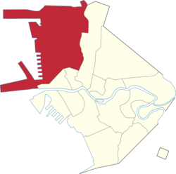
Tondo is a district located in Manila, Philippines. It is the largest, in terms of area and population, of Manila's sixteen districts,[2] with a census-estimated 654,220 people in 2020. It consists of two congressional districts. It is also the second most densely populated district in the city.
Tondo | |
|---|---|
District | |
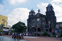 Tondo Church fronting Plaza Leon | |
 | |
 | |
| Country | Philippines |
| Region | National Capital Region |
| City | Manila |
| Congressional district | Manila's 1st (western side) and 2nd districts (eastern side) |
| Area | |
| • Total | 8.65 km2 (3.40 sq mi) |
| Population (2020)[1] | |
| • Total | 654,220 |
| • Density | 76,000/km2 (190,000/sq mi) |
| Time zone | UTC+08:00 (Philippine Standard Time) |
| Zip codes | 1012 (Tondo South) 1013 (Tondo North) |
| Area codes | 2 |
Etymology edit
The name Tondo can be derived from its Old Tagalog name, Tundun as inscribed in the Laguna Copperplate Inscription of 900 AD, the earliest native document found within the Philippines. Dutch anthropologist Antoon Postma, the first to translate the copperplate, believes the term tundun originated from the old Indian language Tamil (Thondai naadu-Chola),[3] which was used alongside Malay as a language of politics and religion in the area at the time.
Before this landmark discovery, several theories (however incorrect now) existed. Philippine National Artist Nick Joaquin once suggested that it might be a reference to a high ground ("tundok").[4] On the other hand, French linguist Jean-Paul Potet, supposed that the Aegiceras corniculatum, which at the time was called "tundok" ("tinduk-tindukan" today), was the most likely origin of the name.[5]
History edit
Early Philippine history edit
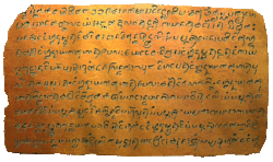
The region of Tondo has been settled by humans for over 1,100 years. Historically, Tondo already existed in the year 900 AD according to the Laguna Copperplate Inscription,[6] a legal document that is the earliest document in the Philippines, written in Kawi script now housed in the National Museum of Anthropology.
According to this document, Tondo was ruled by an unnamed person who held the Sanskrit title of senapati or the equivalent of an admiral. Tondo also had influence all the way to the modern-day province of Bulacan particularly around Lihan (Malolos) and Gatbuca (Calumpit). Tondo was ruled by a line of lakan until the Spanish conquest.
Colonial period edit
Tondo | |||||||||||||
|---|---|---|---|---|---|---|---|---|---|---|---|---|---|
| 1589–1901 | |||||||||||||
| Status | Former municipality of Manila (1589-1901) | ||||||||||||
| History | |||||||||||||
• Established | 1589 | ||||||||||||
• Disestablished | 1901 | ||||||||||||
| |||||||||||||

After the Spaniards conquered Tondo in January 1571 they established the Province of Tondo which covered many territories in Northern Luzon particularly Pampanga, Bulacan and Rizal (formerly called Morong), with the city of Manila as its center. In a census conducted by Miguel de Loarca in 1583, Tondo was reported to have spoken the same language as the natives of the province of Pampanga.[7]
Institute of National Language commissioner Jose Villa Panganiban also wrote that the dividing line between Kapampangan and Tagalog was the Pasig River, and that Tondo therefore originally spoke Kapampangan.[8] However, Fray Isacio Rodriquez's Historia dela Provincia del Santisimo Nombre de Jesus de Filipinas stated that Provincia de Tagalos which is Tondo covers all the territories of the future Roman Catholic Archdiocese of Manila. Prior to the establishment of Bulacan in 1578, Malolos and Calumpit were also included in the territory of Tondo as its visitas. By the end of the 1700s, Tondo was a populous province of 14,437 native families and 3,528 Spanish Filipino families.[9]: 539 [10]: 31, 54, 113 In 1800, the Province of Tondo was renamed to Province of Manila.
Tondo was one of the first provinces to declare rebellion against Spain in the year 1896. In 1901, under the American colonial regime, there was a major reorganization of political divisions, and the province of Tondo was dissolved, with its towns given to the provinces of Rizal and Bulacan. Today, Tondo just exists as a district in the City of Manila.
Contemporary Period edit

Slums developed in Tondo along the Pasig River. Authorities sought to improve housing conditions on these areas without condoning the action of Squatting committed by the slums' residents. In the 1970s, the World Bank provided funds to improve conditions in Tondo which led the increase of rent prices and a property boom in the area. These caused the poor Gentrification. The slums that were upgraded were legalized but these areas remain vastly different from other parts of Manila with higher population density, more irregular road and plot patterns, and uncontrolled housing.[11]
In the 1987 constitution, Tondo was split into two congressional districts of Manila making the first district to the west while the second district in the east.
Economy edit
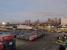
Tondo hosts the Manila North Harbor Port, the northern half of the Port of Manila, the primary seaport serving Metro Manila and surrounding areas.[12]
The area also hosted Smokey Mountain, a landfill which served Metro Manila and employed thousands of people from around 1960s until its closure in the late 1990s. The dumpsite served as a symbol of poverty even at least two decades since its closure.[13]
Demographics edit

Urbanization as well as the Lina Law which favors squatting over land owners has resulted in Tondo being one of the most densely populated areas in the world at 69,000 inhabitants per square kilometer (180,000/sq mi).[14]
Crime edit
Tondo has developed a reputation for criminality and poverty. In 2010, Manila records state that Tondo has the highest criminal rate in the whole city with the most common crime being pickpocketing.[15]
Culture edit
The district celebrates the feast of the Tondo Church annually in January, which is dedicated to the image of the Santo Niño housed within the 16th-century Augustinian Tondo Church. The Lakbayaw Street Dance Festival, a competition among Ati-Atihan groups and school, local and religious groups, served as the climax of the feast.[16]
Education edit
The Department of Education – Schools Division Office of Manila lists 26 public elementary schools and 11 public high schools in Tondo.[17]
Barangays edit
Zones edit
- First District
- Zone 1: Barangays 1 to 9
- Zone 2: Barangays 11 to 20, 25, 26, and 28 to 32
- Zone 3: Barangays 33 to 39 and 41 to 47
- Zone 4: Barangays 48 to 55
- Zone 5: Barangays 56 to 61
- Zone 6: Barangays 62 to 75
- Zone 7: Barangays 76 to 90
- Zone 8: Barangays 91 to 106
- Zone 9: Barangays 107 to 112 and 116 to 123
- Zone 10: Barangays 124 to 128
- Zone 11: Barangays 129 to 134
- Zone 12: Barangays 135 to 146
- Second District
- Zone 13: Barangays 147 to 151
- Zone 14: Barangays 152 to 165
- Zone 15: Barangays 166 to 176
- Zone 16: Barangays 177 to 186
- Zone 17: Barangays 187 to 197
- Zone 18: Barangays 198 to 205
- Zone 19: Barangays 206 to 212
- Zone 20: Barangays 213 to 220
- Zone 21: Barangays 221 to 233
- Zone 22: Barangays 234 to 248
- Zone 23: Barangays 249 to 259
- Zone 24: Barangays 260 to 267
List of barangays edit
| FIRST DISTRICT | ||
| Zone/Barangay | Land area (km²) | Population (2020 census) |
| Zone 1 | ||
| Barangay 1 | 0.04953 km² | 2,995 |
| Barangay 2 | 0.03787 km² | 1,887 |
| Barangay 3 | 0.03893 km² | 1,341 |
| Barangay 4 | 0.04018 km² | 1,691 |
| Barangay 5 | 0.02473 km² | 1,288 |
| Barangay 6 | 0.04150 km² | 771 |
| Barangay 7 | 0.04402 km² | 1,560 |
| Barangay 8 | 0.03638 km² | 147 |
| Barangay 9 | 0.01276 km² | 447 |
| Barangay 10 | 0.006060 km² | 160 |
| Zone 2 | ||
| Barangay 11 | 0.01336 km² | 2,758 |
| Barangay 12 | 0.02056 km² | 2,137 |
| Barangay 13 | 0.01241 km² | 2,371 |
| Barangay 14 | 0.01447 km² | 2,070 |
| Barangay 15 | 0.006980 km² | 1,119 |
| Barangay 16 | 0.01059 km² | 1,477 |
| Barangay 17 | 0.009080 km² | 1,176 |
| Barangay 18 | 0.02325 km² | 1,982 |
| Barangay 19 | 0.01878 km² | 2,272 |
| Barangay 20 | 1.372 km² | 45,772 |
| Barangay 25 | 0.02200 km² | 2,545 |
| Barangay 26 | 0.01961 km² | 2,555 |
| Barangay 28 | 0.02258 km² | 2,787 |
| Barangay 29 | 0.07244 km² | 4,406 |
| Barangay 30 | 0.01179 km² | 166 |
| Barangay 31 | 0.01750 km² | 2,881 |
| Barangay 32 | 0.01606 km² | 2,219 |
| Zone 3 | ||
| Barangay 33 | 0.02387 km² | 4,082 |
| Barangay 34 | 0.01156 km² | 1,854 |
| Barangay 35 | 0.01531 km² | 2,265 |
| Barangay 36 | 0.01173 km² | 2,231 |
| Barangay 37 | 0.009990 km² | 2,057 |
| Barangay 38 | 0.01394 km² | 2,870 |
| Barangay 39 | 0.1038 km² | 2,324 |
| Barangay 41 | 0.02111 km² | 3,825 |
| Barangay 42 | 0.01759 km² | 2,142 |
| Barangay 43 | 0.01292 km² | 3,362 |
| Barangay 44 | 0.05213 km² | 800 |
| Barangay 45 | 0.01765 km² | 2,264 |
| Barangay 46 | 0.01634 km² | 2,088 |
| Barangay 47 | 0.03325 km² | 1,123 |
| Zone 4 | ||
| Barangay 48 | 0.01689 km² | 4,070 |
| Barangay 49 | 0.01984 km² | 2,119 |
| Barangay 50 | 0.03537 km² | 4,217 |
| Barangay 51 | 0.04022 km² | 2,580 |
| Barangay 52 | 0.02638 km² | 2,732 |
| Barangay 53 | 0.02453 km² | 2,916 |
| Barangay 54 | 0.02705 km² | 1,648 |
| Barangay 55 | 0.03648 km² | 2,492 |
| Zone 5 | ||
| Barangay 56 | 0.05299 km² | 3,457 |
| Barangay 57 | 0.02752 km² | 882 |
| Barangay 58 | 0.02985 km² | 3,719 |
| Barangay 59 | 0.02256 km² | 1,112 |
| Barangay 60 | 0.01361 km² | 4,503 |
| Zone 6 | ||
| Barangay 61 | 0.04362 km² | 1,022 |
| Barangay 62 | 0.02066 km² | 1,967 |
| Barangay 63 | 0.01866 km² | 1,448 |
| Barangay 64 | 0.01542 km² | 495 |
| Barangay 65 | 0.01938 km² | 1,631 |
| Barangay 66 | 0.02644 km² | 2,956 |
| Barangay 67 | 0.02007 km² | 4,083 |
| Barangay 68 | 0.007310 km² | 1,115 |
| Barangay 69 | 0.02362 km² | 1,968 |
| Barangay 70 | 0.01273 km² | 2,344 |
| Barangay 71 | 0.03982 km² | 3,417 |
| Barangay 72 | 0.02674 km² | 3,233 |
| Barangay 73 | 0.01038 km² | 2,478 |
| Barangay 74 | 0.02003 km² | 1,039 |
| Barangay 75 | 0.02651 km² | 1,350 |
| Zone 7 | ||
| Barangay 76 | 0.01828 km² | 1,844 |
| Barangay 77 | 0.01281 km² | 1,372 |
| Barangay 78 | 0.01471 km² | 1,221 |
| Barangay 79 | 0.007830 km² | 1,520 |
| Barangay 80 | 0.01168 km² | 2,553 |
| Barangay 81 | 0.01771 km² | 1,815 |
| Barangay 82 | 0.02250 km² | 2,642 |
| Barangay 83 | 0.01402 km² | 1,473 |
| Barangay 84 | 0.01456 km² | 1,141 |
| Barangay 85 | 0.02539 km² | 4,032 |
| Barangay 86 | 0.02075 km² | 1,415 |
| Barangay 87 | 0.02072 km² | 1,633 |
| Barangay 88 | 0.009840 km² | 1,096 |
| Barangay 89 | 0.01241 km² | 720 |
| Barangay 90 | 0.009980 km² | 630 |
| Zone 8 | ||
| Barangay 91 | 0.05655 km² | 4,552 |
| Barangay 92 | 0.02656 km² | 2,639 |
| Barangay 93 | 0.04385 km² | 3,960 |
| Barangay 94 | 0.09789 km² | 2,178 |
| Barangay 95 | 0.03333 km² | 5,543 |
| Barangay 96 | 0.08864 km² | 2,100 |
| Barangay 97 | 0.03041 km² | 3,634 |
| Barangay 98 | 0.01408 km² | 1,899 |
| Barangay 99 | 0.01293 km² | 6,310 |
| Barangay 100 | 0.02934 km² | 2,222 |
| Barangay 101 | 0.1038 km² | 15,358 |
| Barangay 102 | 0.02389 km² | 4,157 |
| Barangay 103 | 0.03294 km² | 4,772 |
| Barangay 104 | 0.03892 km² | 5,741 |
| Barangay 105 | 0.5062 km² | 24,971 |
| Barangay 106 | 0.07641 km² | 2,513 |
| Zone 9 | ||
| Barangay 107 | 0.1578 km² | 7,003 |
| Barangay 108 | 0.03204 km² | 5,391 |
| Barangay 109 | 0.02678 km² | 3,254 |
| Barangay 110 | 0.1781 km² | 2,677 |
| Barangay 111 | 0.01452 km² | 2,661 |
| Barangay 112 | 0.02743 km² | 5,593 |
| Barangay 116 | 0.04229 km² | 5,943 |
| Barangay 117 | 0.02099 km² | 4,160 |
| Barangay 118 | 0.1419 km² | 10,840 |
| Barangay 119 | 0.01863 km² | 2,345 |
| Barangay 120 | 0.01699 km² | 3,873 |
| Barangay 121 | 0.02799 km² | 4,511 |
| Barangay 122 | 0.02322 km² | 3,824 |
| Barangay 123 | 0.09875 km² | 8,660 |
| Zone 10 | ||
| Barangay 124 | 0.03070 km² | 159 |
| Barangay 125 | 0.01540 km² | 4,510 |
| Barangay 126 | 0.1365 km² | 1,162 |
| Barangay 127 | 0.04520 km² | 565 |
| Barangay 128 | 1.067 km² | 23,702 |
| Barangay 129 | 0.04715 km² | 5,716 |
| Zone 11 | ||
| Barangay 130 | 0.03322 km² | 1,758 |
| Barangay 131 | 0.02571 km² | 1,621 |
| Barangay 132 | 0.04207 km² | 925 |
| Barangay 133 | 0.07548 km² | 2,115 |
| Barangay 134 | 0.03383 km² | 1,058 |
| Zone 12 | ||
| Barangay 135 | 0.03240 km² | 1,935 |
| Barangay 136 | 0.02872 km² | 1,197 |
| Barangay 137 | 0.03017 km² | 911 |
| Barangay 138 | 0.02568 km² | 2,939 |
| Barangay 139 | 0.007160 km² | 371 |
| Barangay 140 | 0.03246 km² | 543 |
| Barangay 141 | 0.006960 km² | 529 |
| Barangay 142 | 0.01676 km² | 1,710 |
| Barangay 143 | 0.01029 km² | 1,401 |
| Barangay 144 | 0.03131 km² | 880 |
| Barangay 145 | 0.01763 km² | 1,029 |
| Barangay 146 | 0.03743 km² | 2,895 |
| SECOND DISTRICT | ||
| Zone 13 | ||
| Barangay 147 | 0.1300 km² | 2,275 |
| Barangay 148 | 0.1047 km² | 2,333 |
| Barangay 149 | 0.02148 km² | 1,554 |
| Barangay 150 | 0.04766 km² | 2,277 |
| Barangay 151 | 0.05243 km² | 1,639 |
| Zone 14 | ||
| Barangay 152 | 0.02517 km² | 6,218 |
| Barangay 153 | 0.02093 km² | 2,051 |
| Barangay 154 | 0.02421 km² | 948 |
| Barangay 155 | 0.01807 km² | 3,257 |
| Barangay 156 | 0.04336 km² | 1,615 |
| Barangay 157 | 0.01802 km² | 1,505 |
| Barangay 158 | 0.02412 km² | 1,934 |
| Barangay 159 | 0.01371 km² | 1,558 |
| Barangay 160 | 0.01494 km² | 1,256 |
| Barangay 161 | 0.03005 km² | 1,004 |
| Barangay 162 | 0.02344 km² | 556 |
| Barangay 163 | 0.04533 km² | 3,840 |
| Barangay 164 | 0.02660 km² | 1,807 |
| Barangay 165 | 0.02269 km² | 1,014 |
| Zone 15 | ||
| Barangay 166 | 0.03358 km² | 882 |
| Barangay 167 | 0.02876 km² | 926 |
| Barangay 168 | 0.03009 km² | 1,387 |
| Barangay 169 | 0.02741 km² | 914 |
| Barangay 170 | 0.01939 km² | 1,378 |
| Barangay 171 | 0.02704 km² | 1,124 |
| Barangay 172 | 0.04526 km² | 1,210 |
| Barangay 173 | 0.03045 km² | 1,616 |
| Barangay 174 | 0.02559 km² | 715 |
| Barangay 175 | 0.03679 km² | 988 |
| Barangay 176 | 0.04428 km² | 1,278 |
| Zone 16 | ||
| Barangay 177 | 0.1371 km² | 3,308 |
| Barangay 178 | 0.02283 km² | 1,519 |
| Barangay 179 | 0.03228 km² | 1,021 |
| Barangay 180 | 0.03520 km² | 2,145 |
| Barangay 181 | 0.01847 km² | 2,773 |
| Barangay 182 | 0.05269 km² | 3,936 |
| Barangay 183 | 0.04116 km² | 8,424 |
| Barangay 184 | 0.04504 km² | 3,311 |
| Barangay 185 | 0.03429 km² | 3,532 |
| Barangay 186 | 0.04620 km² | 1,678 |
| Zone 17 | ||
| Barangay 187 | 0.01100 km² | 886 |
| Barangay 188 | 0.01397 km² | 865 |
| Barangay 189 | 0.02422 km² | 1,481 |
| Barangay 190 | 0.01556 km² | 1,232 |
| Barangay 191 | 0.01048 km² | 703 |
| Barangay 192 | 0.03407 km² | 1,878 |
| Barangay 193 | 0.01132 km² | 979 |
| Barangay 194 | 0.01699 km² | 775 |
| Barangay 195 | 0.01056 km² | 1,401 |
| Barangay 196 | 0.02015 km² | 1,631 |
| Barangay 197 | 0.01453 km² | 523 |
| Zone 18 | ||
| Barangay 198 | 0.04329 km² | 5,032 |
| Barangay 199 | 0.03578 km² | 3,471 |
| Barangay 200 | 0.01520 km² | 1,666 |
| Barangay 201 | 0.05224 km² | 1,152 |
| Barangay 202 | 0.03268 km² | 1,420 |
| Barangay 202-A | 0.01950 km² | 1,213 |
| Barangay 203 | 0.06060 km² | 2,462 |
| Barangay 204 | 0.05164 km² | 2,684 |
| Barangay 205 | 0.04640 km² | 1,760 |
| Zone 19 | ||
| Barangay 206 | 0.04145 km² | 2,433 |
| Barangay 207 | 0.04955 km² | 1,541 |
| Barangay 208 | 0.03002 km² | 635 |
| Barangay 209 | 0.06273 km² | 5,075 |
| Barangay 210 | 0.03629 km² | 3,212 |
| Barangay 211 | 0.03119 km² | 2,007 |
| Barangay 212 | 0.02913 km² | 2,675 |
| Zone 20 | ||
| Barangay 213 | 0.03187 km² | 3,231 |
| Barangay 214 | 0.01596 km² | 1,577 |
| Barangay 215 | 0.01780 km² | 3,106 |
| Barangay 216 | 0.03176 km² | 2,431 |
| Barangay 217 | 0.02803 km² | 1,263 |
| Barangay 218 | 0.02250 km² | 321 |
| Barangay 219 | 0.03687 km² | 1,080 |
| Barangay 220 | 0.05358 km² | 1,270 |
| Zone 21 | ||
| Barangay 221 | 0.02506 km² | 3,353 |
| Barangay 222 | 0.01733 km² | 2,040 |
| Barangay 223 | 0.01887 km² | 1,629 |
| Barangay 224 | 0.03784 km² | 1,069 |
| Barangay 225 | 0.01565 km² | 2,419 |
| Barangay 226 | 0.02445 km² | 1,562 |
| Barangay 227 | 0.04637 km² | 1,836 |
| Barangay 228 | 0.01517 km² | 3,010 |
| Barangay 229 | 0.01879 km² | 1,545 |
| Barangay 230 | 0.01091 km² | 2,364 |
| Barangay 231 | 0.02429 km² | 1,888 |
| Barangay 232 | 0.03739 km² | 1,778 |
| Barangay 233 | 0.02135 km² | 735 |
| Zone 22 | ||
| Barangay 234 | 0.04128 km² | 1,945 |
| Barangay 235 | 0.02426 km² | 1,557 |
| Barangay 236 | 0.02861 km² | 801 |
| Barangay 237 | 0.02222 km² | 452 |
| Barangay 238 | 0.01655 km² | 364 |
| Barangay 239 | 0.02265 km² | 1,785 |
| Barangay 240 | 0.01350 km² | 56 |
| Barangay 241 | 0.08630 km² | 447 |
| Barangay 242 | 0.02383 km² | 448 |
| Barangay 243 | 0.01484 km² | 436 |
| Barangay 244 | 0.01323 km² | 640 |
| Barangay 245 | 0.01004 km² | 281 |
| Barangay 246 | 0.01857 km² | 1,254 |
| Barangay 247 | 0.01411 km² | 737 |
| Barangay 248 | 0.008640 km² | 503 |
| Zone 23 | ||
| Barangay 249 | 0.01475 km² | 1,610 |
| Barangay 250 | 0.03508 km² | 1,182 |
| Barangay 251 | 0.009610 km² | 1,181 |
| Barangay 252 | 0.008880 km² | 910 |
| Barangay 253 | 0.02374 km² | 1,329 |
| Barangay 254 | 0.04850 km² | 3,713 |
| Barangay 255 | 0.02253 km² | 1,086 |
| Barangay 256 | 0.02140 km² | 1,030 |
| Barangay 257 | 0.01151 km² | 1,308 |
| Barangay 258 | 0.02197 km² | 1,181 |
| Barangay 259 | 0.06758 km² | 2,090 |
| Zone 24 | ||
| Barangay 260 | 0.03956 km² | 1,641 |
| Barangay 261 | 0.01545 km² | 735 |
| Barangay 262 | 0.04478 km² | 1,736 |
| Barangay 263 | 0.01511 km² | 1,306 |
| Barangay 264 | 0.02586 km² | 2,443 |
| Barangay 265 | 0.01479 km² | 125 |
| Barangay 266 | 0.02719 km² | 1,665 |
| Barangay 267 | 0.01300 km² | 1,952 |
Notable people edit
- Andrés Bonifacio, Filipino revolutionary leader
- Lakandula or Lakan Dula (1503–1575), the last ruler of pre-colonial Tondo when the Spaniards first conquered the lands of the Pasig River delta in the Philippines in the 1570s
- Antonio Villegas, 18th Mayor of Manila City
- Amy Austria, famous actress
- Alfredo Lim, 19th Mayor of Manila
- Rudy Fernandez, actor, movie producer
- Carmen Planas, lawyer
- Tito Arevalo, actor
- Emilio Jacinto, Filipino general
- Mila del Sol, actress
- Esang de Torres, singer, stage actress
- Mona Lisa, actress
- Chichay, comedian
- Dely Atay-Atayan, comedian and singer
- Amado V. Hernandez, labour leader, awarded order national artist of the Philippines
- Charito Solis, actress
- José Palma, soldier, writer
- Lualhati Bautista, novelist
- Gina Alajar, actress and tv director
- Wendell Ramos, actor and firefighter
- Florin Hilbay, attorney
- Levi Celerio, national artist of the Philippines
- Isko Moreno, actor, TV personality and former mayor of Manila
- Ricky Belmonte, actor
- Ramon Ang, businessman, vice-chairman of San Miguel Corporation
- Arnold Clavio, newscaster and journalist
- Rene Requiestas (1957–1993), actor-comedian
- Dolphy, actor-comedian
- Carlos Badion, basketball player
- Ernest Obiena, pole vaulter
- RK Bagatsing, actor-model
- Vice Ganda, actor-comedian
- Raymond Bagatsing, dramatic actor and model
- Jerald Napoles, actor
- Joyce Pring, actress
- Arnel Pineda, singer and the current vocalist of Journey
- Regine Velasquez-Alcasid, singer and songwriter composer
- Ramon Bagatsing, politician and the former mayor of Manila
- Willie Ong, cardiologist
- Geneva Cruz, actress, singer, and composer
- Joseph Estrada, former actor and President
- Valerie Concepcion, actress and television host
- Asiong Salonga, gangster also known as the "King of Tondo"
- McCoy de Leon, actor and dancer
- Francine Diaz, actress and model
- Jose Manalo, comedian, actor
- Sonia Roco, educator
- Ate Gay, comedian
- Irma Adlawan, actress, queen of local indie film
- Bryan “Smugglaz” Lao, FlipTop emcee, rapper and actor
- Michael “Mike Kosa” Castro, rapper
- Jason “J-Skeelz” Yap, rapper
- Christian Carlo “Pistolero” Cañares, FlipTop emcee, rapper
References edit
- ^ "Highlights of the Philippine Population 2015 Census of Population". Philippine Statistics Authority. Archived from the original on October 10, 2017. Retrieved July 11, 2017.
- ^ "Republic Act No. 409: An Act to Revise the Charter of the City of Manila, and for Other Purposes". Official Gazette. Retrieved November 4, 2017.
- ^ Postma, Antoon (1992). "The Laguna Copper-Plate Inscription: Text and Commentary". Philippine Studies. 40 (2): 183–203. JSTOR 42633308.
- ^ Joaqiun, Nick (1990). Manila, My Manila: A History for the Young. City of Manila: Anvil Publishing, Inc. ISBN 978-9715693134.
- ^ Potet, Jean-Paul G. (2013). Arabic and Persian Loanwords in Tagalog. Lulu.com. p. 444. ISBN 9781291457261.
- ^ Morrow, Paul. "The Laguna Copperplate Inscription". Archived from the original on February 5, 2008.
- ^ Miguel de Loarca's Census of 1583.
- ^ Panganiban
- ^ ESTADISMO DE LAS ISLAS FILIPINAS TOMO PRIMERO By Joaquín Martínez de Zúñiga (Original Spanish)
- ^ ESTADISMO DE LAS ISLAS FILIPINAS TOMO SEGUNDO By Joaquín Martínez de Zúñiga (Original Spanish)
- ^ "Settlements & Growth". Creating Neighbourhoods and Places in the Built Environment. Taylor & Francis. September 2, 2003. p. 39. ISBN 1135817901.
- ^ "SMC wrests control of port from Romero". Manila Standard. February 18, 2016. Retrieved March 17, 2018.
- ^ Endo, Jun (March 10, 2017). "Mountain of garbage blights Manila". Nikkei Asian Review. Retrieved March 17, 2018.
- ^ "Tondo: The space in between". Al Jazeera. Retrieved March 17, 2018.
- ^ "Tondo has highest crime rate in Manila". ABS-CBN (in Filipino). August 21, 2010. Retrieved March 17, 2018.
- ^ Santos, Mat (January 20, 2018). "Celebrating the Feast of the Sto. Niño". Manila Bulletin. Retrieved March 17, 2018.
- ^ "DepED Manila Public Schools". Department of Education Manila. Retrieved March 17, 2018.
Further reading edit
- Gaspar de San Agustin, Conquistas de las Islas Filipinas 1565-1615, Translated by Luis Antonio Ma�eru, 1st bilingual ed [Spanish and English], published by Pedro Galende, OSA: Intramuros, Manila, 1998
- Henson, Mariano A. 1965. The Province of Pampanga and Its Towns: A.D. 1300-1965. 4th ed. revised. Angeles City: By the author.
- Loarca, Miguel de. 1582. Relacion de las Yslas Filipinas. Blair and Robertson vol. 5 page 87:
- Panganiban, J.V. 1972. Diksyunaryo-Tesauro Pilipino-Ingles. Quezon City: Manlapaz Publishing Co.
- Mallat, Jean, Les Philippines: Histoire, Geographie, Moeurs, Agriculture, Idustrie, Commerce des colonies Espagnoles dans l'Oc�anie, Paris: Arthus Bertrand, Libraire de la Soci�t� de G�ographie, 1846
- Santiago, Luciano P.R., The Houses of Lakandula, Matanda, and Soliman [1571-1898]: Genealogy and Group Identity, Philippine Quarterly of Culture and Society 18 [1990]
- Scott, William Henry, Barangay: Sixteenth-Century Philippine Culture and Society, Quezon City: Ateneo de Manila University Press, 1994
- Scott, William Henry, Prehispanic Source Materials for the Study of Philippine History, Quezon City: New Day Publishers, 1984
External links edit
- After Fishing in Tondo, Manila, oil on canvas by Fernando Amorsolo, 1927. 58.4 x 96.5 cm.
- Casas de Pescadores en Tondo ("Fishermen's Houses, Tondo"), oil on canvas by Fabian de la Rosa, 1928. 50 x 70 cm.
 Media related to Tondo, Manila at Wikimedia Commons
14°37′01″N 120°58′01″E / 14.617°N 120.967°E