


Summary
The first colonies of the British Empire on the continent of Australia were the penal colony of New South Wales, founded in 1788, and the Swan River Colony (later renamed Western Australia), founded in 1829. Over the next few decades, the colonies of New Zealand, Queensland, South Australia, Van Diemen's Land (later renamed Tasmania), and Victoria were created from New South Wales, as well as an aborted Colony of North Australia. On 1 January 1901, these colonies, excepting New Zealand, became states in the Commonwealth of Australia. Since federation, the internal borders have remained mostly stable, except for the creation of some territories with limited self-government: the Northern Territory from South Australia, to govern the vast, sparsely populated centre of the country; the split of the Northern Territory into Central Australia and North Australia, and then the quick merger of those back into the Northern Territory; and the Australian Capital Territory, a federal district ceded from New South Wales.
Outside of the continent, Queensland attempted an expansion into New Guinea, but British authorities rejected this; the claim would later be made a British protectorate and ceded to Australia. The League of Nations mandated northeast New Guinea to Australia after World War I, as well as Nauru, which was placed under joint Australian-British-New Zealand jurisdiction. These mandates (and, later, United Nations trust territories) became the independent nations of Nauru and Papua New Guinea in the mid-20th century. Australia has also obtained several small island territories, mainly from earlier British colonies, and has a large claim on Antarctica.
Table of changes edit
Key to map colours
- Australian states
- Australian territories and founding colonies
- Area changed by event
Colonial period edit
| Date | Event | Map |
|---|---|---|
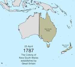
| 25 April 1787 | The Colony of New South Wales was created as a penal colony by the Kingdom of Great Britain in Australia east of 135° east.[1] Word of the establishment was proclaimed in Australia by Governor Arthur Phillip on 7 February 1788.[2] The commission included "all the islands adjacent in the Pacific Ocean" within the latitudes of 10°37' south and 43°39' south, which included most of New Zealand.[1] | 
|
| 11 July 1810 | Macquarie Island was discovered by Frederick Hasselborough, who claimed it for the United Kingdom and declared it part of New South Wales.[3][4] | 
|
| 16 July 1825 | New South Wales was extended west to 129° east, so that it would include a trading post set up on Melville Island; and the borders of the "islands adjacent in the Pacific Ocean" were moved north to 39°12' south, now including only a small part of New Zealand.[5] | 
|
| 3 December 1825 | The southern islands of New South Wales were made the Colony of Van Diemen's Land.[6][7] | 
|
| 2 May 1829 | A colony commonly known as the Swan River Colony was founded in the remainder of Australia outside of New South Wales.[8] Most documents calling for the colony's foundation make no mention of a name, apart from its location at the "Port on the Western Coast of New Holland, at the Mouth of the River called 'Swan River', with the adjacent Territory",[9] and that a settlement should be formed "within the Territory of 'Western Australia'".[10] However, the law calling for the creation of the colony does appear to specify that it should be called "Western Australia".[11] | 
|
| 6 February 1832 | The legal instrument required to formally appoint James Stirling governor of the Colony of Western Australia was proclaimed, and this is commonly held as the date that the Swan River Colony was renamed Western Australia.[12][13] | 
|
| 19 February 1836 | The portion of New South Wales between 132° east and 141° east, and south of 26° south, was made the Province of South Australia.[14] The actual landing and proclamation occurred on 28 December 1836.[15] Its border with New South Wales south of the Murray River would be erroneously surveyed roughly 3.6 kilometres (2.2 mi) west of 141° east, and the resulting disputes with the colonies and, later, states that share that border would not be fully resolved until 1914.[16] | 
|
| 15 June 1839 | The islands of New Zealand were annexed to New South Wales.[17][18] The action was proclaimed on 14 January 1840.[19] | 
|
| 16 November 1840 | The Colony of New Zealand was chartered and split from New South Wales.[20][21] | 
|
| 26 September 1844 | Norfolk Island was transferred from New South Wales to Van Diemen's Land.[22] | 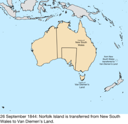
|
| 17 February 1846 | The half of New South Wales north of 26° south was made the Colony of North Australia.[23][24][25] | 
|
| 28 December 1847 | Following a change in government in the United Kingdom, North Australia was merged back in to New South Wales.[23][25] This is the date Queen Victoria revoked the letters patent establishing North Australia, but it was not proclaimed in Australia until 16 January 1849. | 
|
| 1 July 1851 | The portion of New South Wales south of the Murray River and a line from the headwaters of the river to Cape Howe was made the Colony of Victoria.[26] | 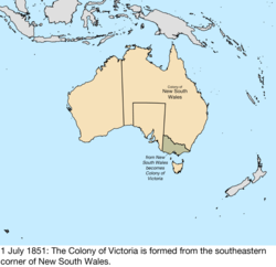
|
| 1 January 1856 | Van Diemen's Land was renamed Tasmania, as a way to get away from its past as a penal colony.[27] | 
|
| 1 November 1856 | Norfolk Island was split from Tasmania, becoming its own colony.[28] Some sources say this occurred the previous day,[29] but the Norfolk Island Act 1913 states it was on this day. | 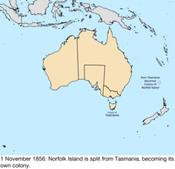
|
| 6 June 1859 | The portion of New South Wales north of 29° south, the Dumaresq and Macintyre Rivers, and several mountain ridges, and east of 141° east, was made the Colony of Queensland.[30] | 
|
| 10 October 1861 | The portion of New South Wales west of South Australia was transferred to South Australia by letters patent. The act of parliament was passed on 22 July 1861.[31] | 
|
| 13 March 1862 | The portion of New South Wales north of South Australia and east of 138° east was transferred to Queensland.[32] | 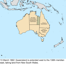
|
| 6 July 1863 | The region of New South Wales north of South Australia was transferred to South Australia.[33] | 
|
| 30 May 1872 | All islands lying within 60 miles (97 km) of Queensland were annexed to the colony by letters patent.[34] This was done primarily to incorporate the Torres Strait Islands, which were starting to be claimed by New South Wales. It is unknown which specific islands may have already been considered part of Queensland, and the map included with the letters patent contained errors, such as including Melville Island in Queensland.[35] | too vague to map |
| 21 July 1879 | The Torres Strait Islands were specifically annexed to Queensland.[34][35] | 
|
| 17 June 1880 | Macquarie Island was made a constituent part of the Colony of Tasmania through Letters Patent for the Governor of Tasmania.[36] | 
|
| 4 April 1883 | Queensland claimed southeast New Guinea as a dependency, though the British government rejected the claim.[37] | 
|
| 6 November 1884 | The British Empire declared southeast New Guinea as a protectorate, removing it from immediate Queensland control, though the colony still largely administered it.[38] | 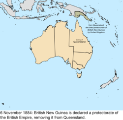
|
Federation edit
| Date | Event | Map |
|---|---|---|
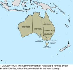
| 1 January 1901 | Six colonies of the United Kingdom formed the Commonwealth of Australia:[39]
Parliament met in Melbourne until the federal capital could be built.[40] |
|
| 1 September 1906 | British New Guinea was transferred from the United Kingdom, becoming the Territory of Papua.[41][42] | 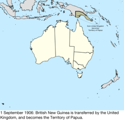
|
| 1 January 1911 | The Federal Capital Territory was split from New South Wales,[43][44] and the Northern Territory was split from South Australia.[45][46] While the acts creating it use the term "Territory for the Seat of Government", legislation and proclamations immediately began using the term "Federal Capital Territory."[47] | 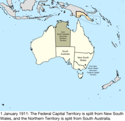
|
| 1 July 1914 | Norfolk Island was transferred from the United Kingdom, becoming the Territory of Norfolk Island.[28][48] | 
|
| 4 September 1915 | A small peninsula along Jervis Bay was ceded to the Federal Capital Territory by New South Wales.[49][50] | 
|
| 17 December 1920 | The League of Nations mandated the former German New Guinea to Australia as the Territory of New Guinea[51][52] and the Mandate of Nauru,[53][54] with New Zealand and the United Kingdom as co-trustees of Nauru.[55] | 
|
| 1 February 1927 | The Northern Territory was split at 20° south into the territories of Central Australia and North Australia.[56][57] | 
|
| 9 May 1927 | Parliament began meeting in Canberra, formally moving the capital there from Melbourne.[58][59] | 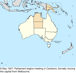
|
| 12 June 1931 | The territories of Central Australia and North Australia were merged to become the Northern Territory.[60][61] | 
|
| 10 May 1934 | The Ashmore and Cartier Islands were transferred from the United Kingdom and became the Territory of Ashmore and Cartier Islands. A British order-in-council dated 23 July 1931 had stated that the islands would be placed under the authority of the Commonwealth of Australia when Australia passed legislation to accept them.[62][63] | 
|
| 24 August 1936 | The United Kingdom transferred the portion of its claim to Antarctica between 45° east and 136° east, and 142° east and 160° east, to Australia, where it became the Australian Antarctic Territory.[64][65] | 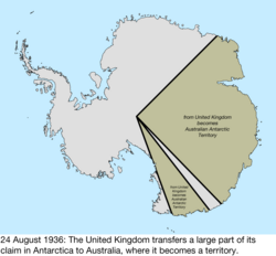
|
| 29 July 1938 | The Territory of Ashmore and Cartier Islands was annexed to the Northern Territory.[66] The Federal Capital Territory was renamed the Australian Capital Territory.[67] |

|
| 26 August 1942 | The Mandate of Nauru was captured by Japan.[68] | 
|
| 14 September 1945 | The Japanese garrison in the Mandate of Nauru surrendered.[68] | 
|
| 13 December 1946 | The Territory of New Guinea was reconstituted as a United Nations trust territory.[69] | 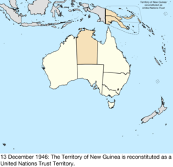
|
| 1 November 1947 | The Mandate of Nauru was reconstituted as the United Nations Trust Territory of Nauru.[69] | 
|
| 26 December 1947 | Heard Island and McDonald Islands were transferred from the United Kingdom. The receipt was confirmed in letters exchanged on 19 December 1950.[70] | 
|
| 1 July 1949 | The Territory of New Guinea and Territory of Papua were merged into the Territory of Papua and New Guinea, mainly for administrative purposes; the act makes it clear that the identities of New Guinea as a United Nations Trust Territory and Papua as a possession of the Crown remain intact.[71][72] | 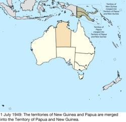
|
| 24 April 1953 | Heard Island and McDonald Islands were formally declared the Territory of Heard Island and McDonald Islands.[73] | 
|
| 23 November 1955 | The Cocos (Keeling) Islands were transferred by the United Kingdom from the Colony of Singapore, becoming the Territory of the Cocos (Keeling) Islands.[74][75] | 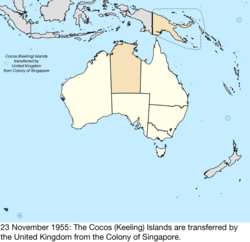
|
| 1 October 1958 | Christmas Island was transferred by the United Kingdom from the Colony of Singapore, becoming the Territory of Christmas Island.[76][77] | 
|
| 31 January 1968 | The Trust Territory of Nauru became independent as the Republic of Nauru.[78][79] | 
|
| 30 September 1969 | The Coral Sea Islands Territory was created from Queensland.[80] | 
|
| 27 December 1971 | The Territory of Papua and New Guinea was renamed Papua New Guinea.[81] | 
|
| 31 December 1973 | The peninsula along Jervis Bay belonging to the Australian Capital Territory was formally named the Jervis Bay Territory; at this time, it was still considered part of the ACT.[82] | no change to map |
| 11 September 1975 | The Republic of the North Solomons declared the independence of the region surrounding Bougainville Island in Papua New Guinea.[83] | 
|
| 16 September 1975 | Papua New Guinea became independent as the Independent State of Papua New Guinea,[84] rendering the dispute with the Republic of the North Solomons moot. | 
|
| 1 July 1978 | The Ashmore and Cartier Islands were split from the Northern Territory, becoming the Territory of Ashmore and Cartier Islands.[85] | 
|
| 3 March 1986 | The Australia Act 1986 made Australia completely independent of the United Kingdom.[86] | no change to map |
| 11 May 1989 | Jervis Bay Territory was split from the Australian Capital Territory to become its own territory.[87] | 
|
| 7 July 1997 | Elizabeth Reef and Middleton Reef were transferred from New South Wales to the Coral Sea Islands Territory.[88] | 
|
Proposed boundary change to the Australian Capital Territory edit
In September 2022, it was announced the border between the Australian Capital Territory and New South Wales would change for the first time since it was created in 1911.[89] ACT chief minister Andrew Barr said NSW premier Dominic Perrottet had agreed to a proposed border change for 330 hectares of land.[90]
See also edit
References edit
- ^ a b "Governor Phillip's Instructions 25 April 1787 (GB)". Museum of Australian Democracy. Archived from the original on 2 August 2017. Retrieved 23 October 2017.
- ^ "Colony of New South Wales: Creation". New South Wales State Archives and Records. Archived from the original on 7 November 2017. Retrieved 18 October 2017.
- ^ Scott, Keith (1993). The Australian Geographic book of Antarctica. Terrey Hills, New South Wales: Australian Geographic. p. 14. ISBN 978-1-86276-010-3.
- ^ Panton, Kenneth J. (2015). Historical Dictionary of the British Empire. Rowman & Littlefield. p. 303. ISBN 9780810875241. Retrieved 18 October 2017.
- ^ "Governor Darling's Commission 1825 (UK)". Museum of Australian Democracy. Archived from the original on 7 November 2017. Retrieved 22 October 2017.
- ^ "Order-in-Council separating Van Diemen's Land from New South Wales 14 June 1825 (UK)". Museum of Australian Democracy. Archived from the original on 7 November 2017. Retrieved 23 October 2017.
- ^ Panton, Kenneth J. (2015). Historical Dictionary of the British Empire. Rowman & Littlefield. p. 518. ISBN 9780810875241. Retrieved 23 October 2017.
- ^ "Instructions to the Admiralty to take formal possession of the western portion of the continent 5 November 1828 (UK)". Museum of Australian Democracy. Archived from the original on 7 November 2017. Retrieved 23 October 2017.
- ^ "Lieutenant-Governor Stirling's Instructions 30 December 1828 (UK)". Museum of Australian Democracy. Archived from the original on 7 November 2017. Retrieved 23 October 2017.
- ^ "Lieutenant-Governor Stirling's Proclamation of the Colony 18 June 1829 (UK)". Museum of Australian Democracy. Archived from the original on 7 November 2017. Retrieved 23 October 2017.
- ^ The Statutes of the United Kingdom of Great Britain and Ireland, Volume 29. Government of the United Kingdom. 1829. p. 719. Retrieved 23 October 2017.
An Act to provide until the Thirty-first Day of December One thousand eight hundred and thirty-four, for the Government of His Majesty's Settlements in Western Australia, on the Western Coast of New Holland
- ^ "Commission appointing Stirling Governor and Commander-in-Chief 4 March 1831 (UK)". Museum of Australian Democracy. Archived from the original on 7 November 2017. Retrieved 23 October 2017.
- ^ "On this day, 6th February 1832, the Swan River colony was officially renamed "Western Australia"". State Library of New South Wales. Retrieved 23 October 2017.
- ^ "Letters Patent establishing the Province of South Australia 19 February 1836 (UK)". Museum of Australian Democracy. Archived from the original on 19 August 2017. Retrieved 23 October 2017.
- ^ "The Proclamation". Government of South Australia. Archived from the original on 29 August 2017. Retrieved 23 October 2017.
- ^ State of South Australia v State of Victoria [1914] UKPC 3, [1914] AC 283, British and Irish Legal Information Institute, retrieved 20 May 2019; [1914] UKPCHCA 1, (1914) 18 CLR 115 (28 January 1914), Privy Council (on appeal from Australia), Australasian Legal Information Institute, retrieved 20 May 2019
- ^ "1839 Letters Patent Establishing New Zealand as Part of New South Wales". Archives New Zealand. Archived from the original on 7 November 2017. Retrieved 25 October 2017.
- ^ "Taming the frontier". New Zealand Government. Archived from the original on 11 July 2017. Retrieved 23 October 2017.
- ^ Report from the select committee on New Zealand. Government of New Zealand. 1840. p. 139. Retrieved 23 October 2017.
- ^ "New Zealand officially becomes British colony". New Zealand Government. Archived from the original on 18 May 2017. Retrieved 23 October 2017.
- ^ New Zealand, Its Advantages and Prospects, as a British Colony. T. & W. Boone. 1842. p. 314. Retrieved 23 October 2017.
- ^ "Norfolk Island Guide". New South Wales Government – State Archives & Records. 4 November 2015. Archived from the original on 11 October 2017. Retrieved 23 October 2017.
- ^ a b "Charters and commissions concerning the Colony of North Australia, 1846–1847". State Library of New South Wales. Archived from the original on 7 November 2017. Retrieved 23 October 2017.
- ^ "PROCLAMATION". New South Wales Government Gazette. No. 13. New South Wales, Australia. 23 January 1849. p. 117. Retrieved 21 May 2019 – via National Library of Australia.
- ^ a b "History of Queensland borders before proclamation". State of Queensland. Archived from the original on 3 October 2018. Retrieved 22 April 2019.
- ^ "Australian Constitutions Act 1850 (UK)". Museum of Australian Democracy. Archived from the original on 7 November 2017. Retrieved 24 October 2017.
- ^ "Order-in-Council changing name to Tasmania 21 July 1855 (UK)". Museum of Australian Democracy. Archived from the original on 7 November 2017. Retrieved 24 October 2017.
- ^ a b Norfolk Island Act 1913 (Cth), Australasian Legal Information Institute, retrieved 20 May 2019
- ^ Bladen, F.M. (1906). "Settlement of the Pitcairn Islanders on Norfolk Island". Journal of the Royal Australian Historical Society. 2 (1). Royal Australian Historical Society: 1–12. ISSN 0035-8762. Retrieved 20 May 2019.
- ^ "Letters Patent erecting Colony of Queensland 6 June 1859 (UK)". Museum of Australian Democracy. Archived from the original on 7 November 2017. Retrieved 24 October 2017.
- ^ Queensland Legislation and South Australian Land Extension Act 1861 (NSW), 22 July 1861, Australasian Legal Information Institute, retrieved 20 May 2019
- ^ "Letters Patent altering the western boundary of Queensland 1862 (UK)". Museum of Australian Democracy. Archived from the original on 7 November 2017. Retrieved 24 October 2017.
- ^ "Letters Patent annexing the Northern Territory to South Australia, 1863". Museum of Australian Democracy. Archived from the original on 7 November 2017. Retrieved 24 October 2017.
- ^ a b "Queensland Coast, Islands and Waters Instruments". Government of Queensland. 11 April 1996. pp. 11–20. Retrieved 21 May 2019.
- ^ a b Mullins, Steve (1992). "Queensland's Quest for Torres Strait: The Delusion of Inevitability". The Journal of Pacific History. 27 (2): 165–180. doi:10.1080/00223349208572705. JSTOR 25169126.
- ^ "Item BB-AU-490 - Letters patent constituting the office of Governor and Commander-in-Chief of the Colony of Tasmania and its Dependencies". University of Tasmania. Retrieved 3 October 2023.
- ^ Australia, Volume 1. Cambridge University Press. 1933. p. 357. ISBN 9780521356213. Retrieved 24 October 2017.
- ^ Van der Veur, Paul W. (2012). Documents and Correspondence on New Guinea's Boundaries. Springer Science & Business Media. pp. 11–12. ISBN 9789401537063. Retrieved 24 October 2017.
- ^ Commonwealth of Australia Constitution Act (Cth), Australasian Legal Information Institute, retrieved 20 May 2019
- ^ "Melbourne – the seat of government". Archived from the original on 12 March 2018. Retrieved 25 October 2017.
- ^ Papua Act 1905 (Cth), Australasian Legal Information Institute, retrieved 20 May 2019
- ^ "PROCLAMATION". Commonwealth of Australia Gazette. No. 47. Australia. 1 September 1906. p. 1141. Retrieved 21 May 2019 – via National Library of Australia.
- ^ Seat of Government Surrender Act 1909 (NSW), Seat of Government Acceptance Act 1909 (Cth); Australasian Legal Information Institute, retrieved 20 May 2019
- ^ "PROCLAMATION". Commonwealth of Australia Gazette. No. 75. Australia. 8 December 1910. p. 1851. Retrieved 21 May 2019 – via National Library of Australia.
- ^ Northern Territory Surrender Act 1908 (SA), Northern Territory Acceptance Act 1910 (Cth); Australasian Legal Information Institute, retrieved 20 May 2019
- ^ "PROCLAMATION". Commonwealth of Australia Gazette. No. 79. Australia. 24 December 1910. p. 1901. Retrieved 21 May 2019 – via National Library of Australia.
- ^ "Seat of Government Acceptance Act 1909 (Cth)". Museum of Australian Democracy. Archived from the original on 12 May 2019. Retrieved 11 May 2019.
- ^ "PROCLAMATION". Commonwealth of Australia Gazette. No. 35. Australia. 17 June 1914. p. 1043. Retrieved 21 May 2019 – via National Library of Australia.
- ^ Seat of Government Surrender Act 1915 (NSW), Jervis Bay Territory Acceptance Act 1915 (Cth); Australasian Legal Information Institute, retrieved 20 May 2019
- ^ "PROCLAMATION". Commonwealth of Australia Gazette. No. 103. Australia. 4 September 1915. p. 1710. Retrieved 21 May 2019 – via National Library of Australia.
- ^ New Guinea Act 1920 (Cth), Australasian Legal Information Institute, retrieved 20 May 2019
- ^ Australian Treaty Series 1920 No 2 Archived 17 May 2007 at the Wayback Machine, Australasian Legal Information Institute, retrieved 20 May 2019
- ^ Nauru Island Agreement Act 1919 (Cth), Australasian Legal Information Institute, retrieved 20 May 2019
- ^ Australian Treaty Series 1923 No 11 Archived 4 June 2012 at archive.today, Australasian Legal Information Institute, retrieved 20 May 2019
- ^ Blakeslee, George H. (1922). "The Mandates of the Pacific". Foreign Affairs. 1 (1): 98–115. doi:10.2307/20028201. JSTOR 20028201.
- ^ Northern Australia Act 1926 (Cth), Australasian Legal Information Institute, retrieved 20 May 2019
- ^ "PROCLAMATION". Commonwealth of Australia Gazette. No. 7. Australia. 27 January 1927. p. 137. Retrieved 21 May 2019 – via National Library of Australia.
- ^ "As it was in the Beginning (Parliament House in 1927)". Parliament of Australia. Archived from the original on 31 July 2017. Retrieved 4 August 2017.
- ^ "Government Gazette Notices". Commonwealth of Australia Gazette. No. 48. Australia. 9 May 1927. p. 901. Retrieved 21 May 2019 – via National Library of Australia.
- ^ Northern Territory (Administration) Act 1931 (Cth), Australasian Legal Information Institute, retrieved 20 May 2019
- ^ "PROCLAMATION". Commonwealth of Australia Gazette. No. 46. Australia. 11 June 1931. p. 931. Retrieved 21 May 2019 – via National Library of Australia.
- ^ Ashmore and Cartier Islands Acceptance Act 1933 (Cth), Australasian Legal Information Institute, retrieved 20 May 2019
- ^ "PROCLAMATION". Commonwealth of Australia Gazette. No. 28. Australia. 10 May 1934. p. 761. Retrieved 21 May 2019 – via National Library of Australia.
- ^ Australian Antarctic Territory Acceptance Act 1933 (Cth), Australasian Legal Information Institute, retrieved 20 May 2019
- ^ "ACTS OF PARLIAMENT ASSENTED TO". Commonwealth of Australia Gazette. No. 39. Australia. 22 June 1933. p. 896. Retrieved 21 May 2019 – via National Library of Australia.
- ^ Ashmore and Cartier Islands Acceptance Act 1938 Archived 7 November 2017 at the Wayback Machine (Cth), Government of Australia, retrieved 20 May 2019
- ^ Seat of Government Acceptance Act 1938 (Cth), Australasian Legal Information Institute, retrieved 20 May 2019
- ^ a b "ICJ – Application of the Republic of Nauru" [1990] AUIntLawNews 18; (1990) Australian International Law News 156 Archived 7 November 2017 at the Wayback Machine, Australasian Legal Information Institute, retrieved 20 May 2019
- ^ a b Decolonization No 30 Part 2 Archived 12 September 2016 at the Wayback Machine, United Nations, retrieved 20 May 2019
- ^ Gordon-Walker, P.C. (1951). "Administration of Heard Island and the McDonald Islands". Polar Record. 6 (42): 275–276. doi:10.1017/S0032247400040808.
- ^ Papua New Guinea Act 1949 Archived 7 November 2017 at the Wayback Machine (Cth), Government of Australia, retrieved 20 May 2019
- ^ "PROCLAMATION". Commonwealth of Australia Gazette. No. 48. Australia. 30 June 1949. p. 1897. Retrieved 21 May 2019 – via National Library of Australia.
- ^ Heard Island and McDonald Islands Act 1953 (Cth), Australasian Legal Information Institute, retrieved 20 May 2019
- ^ Cocos (Keeling) Islands Act 1955 Archived 7 November 2017 at the Wayback Machine (Cth), Government of Australia, retrieved 20 May 2019
- ^ "PROCLAMATION". Commonwealth of Australia Gazette. No. 58. Australia. 10 November 1955. p. 3665. Retrieved 21 May 2019 – via National Library of Australia.
- ^ Christmas Island Act 1958 (Cth), Australasian Legal Information Institute, retrieved 20 May 2019
- ^ "Handover of Christmas Island to Australia". Infopedia. 1 September 2014. Retrieved 29 September 2022.
- ^ Nauru Independence Act 1967 (Cth), Australasian Legal Information Institute, retrieved 20 May 2019
- ^ "Constitution of Nauru". Government of Nauru. Archived from the original on 6 August 2017. Retrieved 3 August 2017.
- ^ Coral Sea Islands Act 1969 (Cth), Australasian Legal Information Institute, retrieved 20 May 2019
- ^ Papua New Guinea Act 1971 (Cth), Australasian Legal Information Institute, retrieved 20 May 2019
- ^ Jervis Bay Territory Acceptance Act 1915–1973 Archived 20 November 2017 at the Wayback Machine, Government of Australia, retrieved 15 November 2017
- ^ "Chronology of Bougainville Civil War". Pacific Islands Report. Archived from the original on 3 December 2018. Retrieved 20 May 2019.
- ^ Papua New Guinea Independence Act 1975 (Cth), Australasian Legal Information Institute, retrieved 20 May 2019
- ^ Ashmore and Cartier Islands Acceptance Amendment Act 1978 (Cth), Australasian Legal Information Institute, retrieved 20 May 2019
- ^ "Australia Act 1986 (Cth)". Museum of Australian Democracy. Archived from the original on 22 April 2019. Retrieved 22 April 2019.
- ^ A.C.T. Self-Government (Consequential Provisions) Act 1988 Archived 20 November 2017 at the Wayback Machine, Government of Australia, retrieved 15 November 2017
- ^ Environment, Sport and Territories Legislation Amendment Act 1997 (Cth), Australasian Legal Information Institute, retrieved 20 May 2019
- ^ "'It's happening': NSW-ACT border to change for first time since its creation as territory expands". ABC News. 16 September 2022. Retrieved 16 September 2022.
- ^ "NSW and ACT in talks over biggest border shake-up in living memory". the Guardian. 16 September 2022. Retrieved 16 September 2022.
External links edit
- States of Australia – Statoids.com
- The Australian Institute of Aboriginal and Torres Strait Islander Studies provides a map of estimated territorial boundaries of the various First Nations of Australia