
KNOWPIA
WELCOME TO KNOWPIA

Targon 
Summary
Targon (French pronunciation: [taʁɡɔ̃]) is a commune in the Gironde department in Nouvelle-Aquitaine in southwestern France.
Targon | |
|---|---|
 The town hall in Targon | |
 Coat of arms | |
Location of Targon .mw-parser-output .locmap .od{position:absolute}.mw-parser-output .locmap .id{position:absolute;line-height:0}.mw-parser-output .locmap .l0{font-size:0;position:absolute}.mw-parser-output .locmap .pv{line-height:110%;position:absolute;text-align:center}.mw-parser-output .locmap .pl{line-height:110%;position:absolute;top:-0.75em;text-align:right}.mw-parser-output .locmap .pr{line-height:110%;position:absolute;top:-0.75em;text-align:left}.mw-parser-output .locmap .pv>div{display:inline;padding:1px}.mw-parser-output .locmap .pl>div{display:inline;padding:1px;float:right}.mw-parser-output .locmap .pr>div{display:inline;padding:1px;float:left}html.skin-theme-clientpref-night .mw-parser-output .od,html.skin-theme-clientpref-night .mw-parser-output .od .pv>div,html.skin-theme-clientpref-night .mw-parser-output .od .pl>div,html.skin-theme-clientpref-night .mw-parser-output .od .pr>div{background:#000;color:#fff}html.skin-theme-clientpref-night .mw-parser-output .locmap{filter:grayscale(0.6)}@media(prefers-color-scheme:dark){html.skin-theme-clientpref-os .mw-parser-output .locmap{filter:grayscale(0.6)}html.skin-theme-clientpref-os .mw-parser-output .od,html.skin-theme-clientpref-os .mw-parser-output .od .pv>div,html.skin-theme-clientpref-os .mw-parser-output .od .pl>div,html.skin-theme-clientpref-os .mw-parser-output .od .pr>div{background:#000;color:#fff}}  Targon  Targon | |
| Coordinates: 44°44′08″N 0°15′45″W / 44.7356°N 0.2625°W | |
| Country | France |
| Region | Nouvelle-Aquitaine |
| Department | Gironde |
| Arrondissement | Langon |
| Canton | L'Entre-Deux-Mers |
| Intercommunality | CC rurales de l'Entre-Deux-Mers |
| Government | |
| • Mayor (2020–2026) | Frédéric Maulun[1] |
| Area 1 | 25.88 km2 (9.99 sq mi) |
| Population (2021)[2] | 2,044 |
| • Density | 79/km2 (200/sq mi) |
| Time zone | UTC+01:00 (CET) |
| • Summer (DST) | UTC+02:00 (CEST) |
| INSEE/Postal code | 33523 /33760 |
| Elevation | 37–118 m (121–387 ft) (avg. 57 m or 187 ft) |
| 1 French Land Register data, which excludes lakes, ponds, glaciers > 1 km2 (0.386 sq mi or 247 acres) and river estuaries. | |
Population edit
| Year | Pop. | ±% p.a. |
|---|---|---|
| 1968 | 1,132 | — |
| 1975 | 1,195 | +0.78% |
| 1982 | 1,435 | +2.65% |
| 1990 | 1,609 | +1.44% |
| 1999 | 1,685 | +0.51% |
| 2007 | 1,888 | +1.43% |
| 2012 | 1,885 | −0.03% |
| 2017 | 2,077 | +1.96% |
| Source: INSEE[3] | ||
Sights and monuments edit
- Église Saint-Romain de Targon, 12th century Romanesque church, listed as a monument historique since 1925.[4]
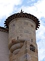
- Église de Montarouch, 13th century Romanesque church, once the property of the Knights Hospitaller, now in ruins, listed as a monument historique since 1925.[5]
-
 Saint-Romain church, south west view (June 2013)
 -
 South façade and doorway to the church (June 2013)
 -
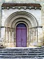 Doorway (June 2013)
 -
-
 Ruins of Montarouch church, south view (June 2013)
 -
 Montarouch church, east view (June 2013)
 -
 Monument to the dead in front of Saint-Romain church (June 2013)


See also edit
References edit
Wikimedia Commons has media related to Targon.
- ^ "Répertoire national des élus: les maires" (in French). data.gouv.fr, Plateforme ouverte des données publiques françaises. 13 September 2022.
- ^ "Populations légales 2021". The National Institute of Statistics and Economic Studies. 28 December 2023.
- ^ Population en historique depuis 1968, INSEE
- ^ Base Mérimée: Eglise Saint-Romain, Ministère français de la Culture. (in French)
- ^ Base Mérimée: Ruines de l'église de Montarouch, Ministère français de la Culture. (in French)