


Summary
Shah Allah Ditta (Urdu: شاہ اللہ دتہ) is a centuries-old village and a union council located at the foothills of the Margalla Hills in the Islamabad Capital Territory, Pakistan. It s located adjacent to Sector D-12 of Islamabad.[1]
Shah Allah Ditta
شاہ اللہ دتہ | |
|---|---|
 Shah Allah Ditta's Sadhu da Bagh caves are an ancient Buddhist monastic site | |
 Shah Allah Ditta Location in Islamabad Capital Territory | |
| Coordinates: 33°43′15″N 72°54′52″E / 33.7209642°N 72.9143201°E | |
| Country | |
| Province | |
| Government | |
| Time zone | UTC+5 (PST) |
Etymology edit

History edit
The village is believed to be more than seven hundred years old and lies on the route which was used to travel from Kabul to the Gandharan city of Taxila by Alexander the Great and Sher Shah Suri, while Mughal rulers and other emperors often passed through while traveling from Afghanistan to the Hindustan. Local people used to call that route Gernaili Road (Sher Shah's road), and some of its remnants are still visible today. It is said that Mughal emperor Akbar built a watering hole for travelers in this village.[1]
Archeology edit
Relics of the Buddhist era dating back to the 8th century can be found here along with burnt diyas and trees with amulets tied to them.
Shah Allah Ditta caves[3] are located on the route leading towards Khanpur. These caves are next to the shrine and tomb of Shah Allah Ditta.[4]
2,400-year-old Buddhist era murals[5] of Buddha appear on the walls of caves at Shah Allah Ditta.[6]
Archaeological evidence indicates that the caves and the platform-like formations surrounding the area were first used for meditation by Buddhist monks and later by Hindu sadhus before Muslim ascetics took over during the Mughal period.
Marked on the ground close to the caves the location where Alexander arrived and was received by Raja Ambi, King of Taxila. The road next to the caves that leads to the main top of the mountain, Shah Allah Ditta road, is said to be built on the exact path followed by Pashtun emperor Sher Shah Suri during his visit.
Moving up the mountain from the caves, there is a stepwell called Losar Baoli and a mosque built by Shahāb-ud-Din Ghori. The mosque has broken walls and the road leading to it is dilapidated.
Preservation edit
- In October 2010, Capital Development Authority (CDA) finally approved the plan after realizing the importance to preserve this 2,400-year-old archeological site.[7] The plan covers conservation of the Buddha caves as well as the adjacent garden known as 'Sadhu ka Bagh'.[8] This is the second heritage site in Islamabad which has been targeted for preservation; the first was the historical Saidpur Village, also situated at the foothills of the Margallas.
- The Taxila Institute of Asian Studies, Quaid-i-Azam University, the Natural History Museum and Department of Architecture, and a recent effort by the Mass Communication Department of NUST has urged the government to preserve[9] such sites of Mughal heritage.
- Embassy of Japan in Pakistan, reportedly offered to provide funds for the preservation of Shah Allah Ditta caves.[9]
Residential land edit
There is approx. 23,000 kanal land located in Shah Allah Ditta village and its surroundings.[10]
As of July 2011, approx. 17,000 kanal land is privately owned, and approx. 6,000 kanal of land has been purchased by the housing society developers of sectors D-13, E-13 and C-13.[10]
The federal government has only 30 kanals of land in and around Shah Allah Ditta.
Margalla Ridge Trail edit
The village also serves as the starting point of the Margalla Ridge Trail. Inaugurated on 3 November 2018 as Pakistan's longest single trans-provincial trail, 15 of its 44 km length lies within Islamabad Capital Territory, while the rest passes through districts Abbottabad and Haripur in the Khyber Pakhtunkhwa province. It passes though six villages, including Talhar (in Islamabad Capital Territory) and Lora (in Khyber Pakhtunkhwa), and has multiple exit points.[11] It ends at Summa.[12]
Gallery edit
-
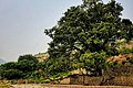 The Sadhu ka Bagh near the caves

See also edit
References edit
- ^ a b Khalil, Wali Imran (2018-05-07). "A Trip To Shah Allah Ditta". Dunya News. Retrieved 2023-03-18.
- ^ "Shah Allah Ditta Caves". paktourismportal.com.
- ^ "Shah Allah Ditta Caves".
- ^ "Islamabad: Shah Allah Ditta caves need immediate preservation | Pak Tea House". pakteahouse.net. Archived from the original on 2011-10-26.
- ^ "Buddhist Channel | Archaeology". www.buddhistchannel.tv.
- ^ "Another Buddhist site found in Islamabad". 14 April 2011.
- ^ "Daily Times - Latest Pakistan News, World, Business, Sports, Lifestyle".
- ^ "CDA starts Sadhu Ka bagh park in Shah Allah". Archived from the original on 2012-02-02. Retrieved 2011-08-19.
- ^ a b Mussadaq, Maha (23 June 2010). "Caves of Mughal heritage fading from memory". The Express Tribune. Retrieved 2023-03-18.
- ^ a b "Woe to Shangrila". Dawn. 2011-07-27. Retrieved 2023-03-18.
- ^ Junaidi, Ikram (2018-11-04). "Longest single trans-provincial trail in Pakistan inaugurated". Dawn. Retrieved 2023-03-18.
- ^ "New trail to be developed in Shah Allah Ditta". www.thenews.com.pk. Retrieved 2023-03-18.
External links edit
- Sadhu Ka Bagh Project
- A memorable trip to Shah Allah Ditta
- Photography: Shah Allah Ditta Caves