


Summary
Ramon, officially the Municipality of Ramon (Ilocano: Ili ti Ramon; Tagalog: Bayan ng Ramon), is a 2nd class municipality in the province of Isabela, Philippines. According to the 2020 census, it has a population of 56,523 people.[3]
Ramon | |
|---|---|
| Municipality of Ramon | |
 Street of Ramon | |
 Flag  Seal | |
| Nickname(s): Tilapia Capital of Isabela Hub of Magat Dam | |
| Motto: Aramid ti pakakitaan | |
 Map of Isabela with Ramon highlighted | |
OpenStreetMap .mw-parser-output .locmap .od{position:absolute}.mw-parser-output .locmap .id{position:absolute;line-height:0}.mw-parser-output .locmap .l0{font-size:0;position:absolute}.mw-parser-output .locmap .pv{line-height:110%;position:absolute;text-align:center}.mw-parser-output .locmap .pl{line-height:110%;position:absolute;top:-0.75em;text-align:right}.mw-parser-output .locmap .pr{line-height:110%;position:absolute;top:-0.75em;text-align:left}.mw-parser-output .locmap .pv>div{display:inline;padding:1px}.mw-parser-output .locmap .pl>div{display:inline;padding:1px;float:right}.mw-parser-output .locmap .pr>div{display:inline;padding:1px;float:left}html.skin-theme-clientpref-night .mw-parser-output .od,html.skin-theme-clientpref-night .mw-parser-output .od .pv>div,html.skin-theme-clientpref-night .mw-parser-output .od .pl>div,html.skin-theme-clientpref-night .mw-parser-output .od .pr>div{background:#000;color:#fff}html.skin-theme-clientpref-night .mw-parser-output .locmap{filter:grayscale(0.6)}@media(prefers-color-scheme:dark){html.skin-theme-clientpref-os .mw-parser-output .locmap{filter:grayscale(0.6)}html.skin-theme-clientpref-os .mw-parser-output .od,html.skin-theme-clientpref-os .mw-parser-output .od .pv>div,html.skin-theme-clientpref-os .mw-parser-output .od .pl>div,html.skin-theme-clientpref-os .mw-parser-output .od .pr>div{background:#000;color:#fff}}  Ramon Location within the Philippines | |
| Coordinates: 16°47′N 121°32′E / 16.78°N 121.53°E | |
| Country | Philippines |
| Region | Cagayan Valley |
| Province | Isabela |
| District | 3rd district |
| Founded | January 1, 1964 |
| Named for | Ramon Elento |
| Barangays | 19 (see Barangays) |
| Government | |
| • Type | Sangguniang Bayan |
| • Mayor | Jesus D. Laddaran |
| • Vice Mayor | Dennis Jon A. Dela Cruz |
| • Representative | Ian Paul L. Dy |
| • Electorate | 34,940 voters (2022) |
| Area | |
| • Total | 135.17 km2 (52.19 sq mi) |
| Elevation | 101 m (331 ft) |
| Highest elevation | 154 m (505 ft) |
| Lowest elevation | 79 m (259 ft) |
| Population (2020 census)[3] | |
| • Total | 56,523 |
| • Density | 420/km2 (1,100/sq mi) |
| • Households | 14,823 |
| Economy | |
| • Income class | 2nd municipal income class |
| • Poverty incidence | 13.40 |
| • Revenue | ₱ 247.4 million (2020) |
| • Assets | ₱ 591 million (2020) |
| • Expenditure | ₱ 206.5 million (2020) |
| • Liabilities | ₱ 218.4 million (2020) |
| Service provider | |
| • Electricity | Isabela 1 Electric Cooperative (ISELCO 1) |
| Time zone | UTC+8 (PST) |
| ZIP code | 3319 |
| PSGC | 023124000 |
| IDD : area code | +63 (0)78 |
| Native languages | Ilocano Gaddang Tagalog |
| Website | www |
Etymology edit
The municipality was named in honor of the late President Ramon Magsaysay. Magsaysay municipality was chartered June 22, 1957, and was renamed to Delfin Albano on November 14, 1982.
History edit
The site of Ramon was previously inhabited by Gaddangs. In 1846, the Spanish put up a fortress named Begonia in the area to defend the neighboring Christian settlements from attacks by Ifugaos and as a stepping stone for the conquest of Ifugao. In 1882, settlement that grew around the fort was officially founded and renamed Oscariz after Don Mariano Oscariz, a former Military Governor of Nueva Vizcaya, to which the town belonged to until the creation of the province of Isabela in 1856. Oscariz was officially recognized as a town by virtue of a Royal Decree dated September 12, 1896.[5]
From January to February 1900, President Emilio Aguinaldo stayed in Oscariz while fleeing from American forces during the Philippine-American War. After the establishment of American rule, Oscariz was abolished as a town and became a barrio of Santiago.[6]
In the middle of the 1920s when the San Jose–Santa Fe national road opened, Ilocano migrants from the Central Plain of Luzon, particularly Tarlac, Pangasinan, and Nueva Ecija, arrived in bull carts to settle on this vast area covered with weeds called “samon” as homesteaders. As required by statutes, these people stayed right on their 24 hectares (59 acres) farms to clear the lot in order call it their own. The place was a part of Buenavista, the oldest barrio of Santiago, Isabela. For more than ten years amidst hardships and sufferings due to malaria and unfavorable weather conditions, the pioneers labored to convert their homestead into a productive farm with palay as their main crop.
In 1937, the Santiago–Tuguegarao Road via the Mallig Plains was opened and more immigrants came to farm in the place. This area which is 10 kilometres (6.2 mi) away from the town proper of Santiago later emerged to become barrio Bugallon, eventually becoming the biggest barrio of Santiago.
The completion of the Maris Dam at Ambatali in 1957 attracted more migrants to farm at the irrigated areas of Bugallon. Along with the Ilocano arrivals were a few Tagalogs, Pangasinenses, and many others.
The municipality of Ramon was created on June 18, 1961, by virtue of Republic Act No. 3320 sponsored by the then Congressman Delfin Albano of the then lone district of Isabela. On November 12, 1963, the first set of local officials were elected with Angelino F. Vizcarra as Municipal Mayor.
The original seat of government was first conceived to be established 500 meters north of Barangay Burgos. However, the local officials decided to temporarily locate the site at Bugallon which eventually became the permanent site by virtue of Republic Act No. 11354, upon which a two-storey Municipal Hall was built on December 8, 1968.
The municipality was originally classified as a seventh class municipality at the time of its inauguration on January 1, 1964. Ramon had 12 original barangays carved out from the municipalities of San Mateo and Santiago. In 1966, another barangay was annexed from the municipality of Echague. Later, by virtue of the revised Barangay Charter or Republic Act. No. 3590, six additional barangays were created.
The rural Electrification Program of ISELCO I was completed in the latter part of the 1970s.
With the completion of the Magat Dam in 1983, more areas were converted into irrigated rice lands which attracted further migration to the municipality, including Igorots and Ifugaos from the Cordilleras.
Geography edit
The municipality of Ramon has a semi-radial but more defined linear development along the national road from Santiago City in the south to San Mateo towards the north. With the completion of the Magat River Multi-purpose high dam near the Isabela-Ifugao provincial boundary, the trend of expansion has deviated westward.
Ramon is 83 kilometres (52 mi) from Ilagan and 337 kilometres (209 mi) from Manila.
Barangays edit
Ramon is politically subdivided into 19 barangays. Each barangay consists of puroks while some have sitios.
- Ambatali
- Bantug
- Bugallion Norte
- Bugallion Proper (Centro)
- Burgos
- General Aguinaldo
- Nagbacalan
- Oscariz
- Pabil
- Pagrang-ayan
- Planas
- Purok ni bulan
- Raniag
- San Miguel
- San Antonio
- San Sebastian
- Villa Beltran
- Villa Carmen
- Villa Marcos
Climate edit
| Climate data for Ramon, Isabela | |||||||||||||
|---|---|---|---|---|---|---|---|---|---|---|---|---|---|
| Month | Jan | Feb | Mar | Apr | May | Jun | Jul | Aug | Sep | Oct | Nov | Dec | Year |
| Mean daily maximum °C (°F) | 31 (88) |
31 (88) |
32 (90) |
34 (93) |
35 (95) |
34 (93) |
32 (90) |
32 (90) |
32 (90) |
32 (90) |
32 (90) |
31 (88) |
32 (90) |
| Mean daily minimum °C (°F) | 22 (72) |
22 (72) |
22 (72) |
24 (75) |
24 (75) |
24 (75) |
24 (75) |
24 (75) |
24 (75) |
23 (73) |
23 (73) |
22 (72) |
23 (74) |
| Average precipitation mm (inches) | 13.6 (0.54) |
10.4 (0.41) |
18.2 (0.72) |
15.7 (0.62) |
178.4 (7.02) |
227.9 (8.97) |
368 (14.5) |
306.6 (12.07) |
310.6 (12.23) |
215.7 (8.49) |
70.3 (2.77) |
31.1 (1.22) |
1,766.5 (69.56) |
| Average rainy days | 3 | 2 | 2 | 4 | 14 | 16 | 23 | 21 | 24 | 15 | 10 | 6 | 140 |
| Source: World Weather Online[7] | |||||||||||||
Demographics edit
| Year | Pop. | ±% p.a. |
|---|---|---|
| 1970 | 15,211 | — |
| 1975 | 17,841 | +3.25% |
| 1980 | 30,815 | +11.55% |
| 1990 | 33,444 | +0.82% |
| 1995 | 35,885 | +1.33% |
| 2000 | 41,441 | +3.13% |
| 2007 | 45,258 | +1.22% |
| 2010 | 49,812 | +3.55% |
| 2015 | 52,707 | +1.08% |
| 2020 | 56,523 | +1.38% |
| Source: Philippine Statistics Authority[8][9][10][11] | ||
In the 2020 census, the population of Ramon, Isabela, was 56,523 people,[3] with a density of 420 inhabitants per square kilometre or 1,100 inhabitants per square mile.
Economy edit
Endowed with prime agricultural lands, the majority of its inhabitants derive their income from agriculture. Ramon ranks among the top rice-producing towns of Isabela alongside the towns of Alicia and San Mateo.
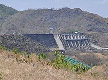
The northern border of Ramon is the Magat River that provides power to national grid though the Magat Dam. The dam is a major employer in Barangay General Aguinaldo and has the works buildings and staff compounds situated there also. An undeveloped airport is in the area next to the river.
Ramon functions as a satellite town of Santiago City, a major growth center in southern Isabela. The Magat River Multi-purpose project, likewise, provides the municipality economic and social gains brought about by the influx of technological advancements like irrigation and electric power.
Culture edit
Since 1948, Ramon was a mission of Santiago. It was only in 1978 that Ramon had a resident priest and on March 28, 1981, Bishop Miguel Purugganan canonically erected the town into the status of a parish with Fr. Conrad Blanchet, MS as its first official parish priest.
Former Bishop Sergio L. Utleg, D.D., the Ordinary of the Diocese of Ilagan (now the Archbishop of the Archdiocese of Tuguegarao), offered the Parish of San Roque to remain under the "in perpetuum" care of the Missionaries of Our Lady of La Salette. The Provincial Superior, in deliberation with his Council, accepted the offer on June 29, 2004. With this event, Ramon is the only remaining parish entrusted to the Missionaries of Our Lady of La Salette.
Government edit
Local government edit
As a municipality in the Province of Isabela, government officials in the provincial level are voted by the electorates of the town. The provincial government have political jurisdiction over local transactions of the municipal government.
The municipality of Ramon is governed by a mayor designated as its local chief executive and by a municipal council as its legislative body in accordance with the Local Government Code. The mayor, vice mayor, and the councilors are elected directly by the people through an election which is being held every three years.
Barangays are also headed by elected officials: Barangay Captain, Barangay Council, whose members are called Barangay Councilors. The barangays have SK federation which represents the barangay, headed by SK chairperson and whose members are called SK councilors. All officials are also elected every three years.
Elected officials edit
| Position | Name |
|---|---|
| District Representative | Ian Paul L. Dy |
| Municipal Mayor | Jesus D. Laddaran |
| Municipal Vice-Mayor | Dennis Jon A. Dela Cruz |
| Municipal Councilors | Giovanni M. Vizcarra |
| Melvin Cristobal | |
| Myrna Navarro | |
| Rita T. Banhan | |
| Arlyn Keith Alethea L. Esteban | |
| Rodrigo D. Terte | |
| Candido C. Natividad, Jr. | |
| Danilo M. Vizcarra |
Jesse Leonard V. Laddaran ABC President
Nemerson T. Manuel SK Federation President
Congress representation edit
Ramon, belonging to the third legislative district of the province of Isabela, currently represented by Hon. Ian Paul L. Dy.[20]
Education edit
The Schools Division of Isabela governs the town's public education system.[21] The division office is a field office of the DepEd in Cagayan Valley region.[22] The office governs the public and private elementary and public and private high schools throughout the municipality.
References edit
- ^ Municipality of Ramon | (DILG)
- ^ "2015 Census of Population, Report No. 3 – Population, Land Area, and Population Density" (PDF). Philippine Statistics Authority. Quezon City, Philippines. August 2016. ISSN 0117-1453. Archived (PDF) from the original on May 25, 2021. Retrieved July 16, 2021.
- ^ a b c Census of Population (2020). "Region II (Cagayan Valley)". Total Population by Province, City, Municipality and Barangay. Philippine Statistics Authority. Retrieved July 8, 2021.
- ^ "PSA Releases the 2018 Municipal and City Level Poverty Estimates". Philippine Statistics Authority. December 15, 2021. Retrieved January 22, 2022.
- ^ Salgado, Pedro. "Formation of Christian Towns in Diffun (Southern Isabela)". Cagayan Valley and Easter Cordillera: 1581-1898, Volume I. Rex Publishing. pp. 589–590.
- ^ "HISTORICAL DEVELOPMENT OF THE MUNICIPALITY OF RAMON, ISABELA" (PDF). Retrieved May 22, 2023.
- ^ "Ramon, Isabela: Average Temperatures and Rainfall". World Weather Online. Retrieved October 31, 2015.
- ^ Census of Population (2015). "Region II (Cagayan Valley)". Total Population by Province, City, Municipality and Barangay. Philippine Statistics Authority. Retrieved June 20, 2016.
- ^ Census of Population and Housing (2010). "Region II (Cagayan Valley)" (PDF). Total Population by Province, City, Municipality and Barangay. National Statistics Office. Retrieved June 29, 2016.
- ^ Censuses of Population (1903–2007). "Region II (Cagayan Valley)". Table 1. Population Enumerated in Various Censuses by Province/Highly Urbanized City: 1903 to 2007. National Statistics Office.
{{cite encyclopedia}}: CS1 maint: numeric names: authors list (link) - ^ "Province of Isabela". Municipality Population Data. Local Water Utilities Administration Research Division. Retrieved December 17, 2016.
- ^ "Poverty incidence (PI):". Philippine Statistics Authority. Retrieved December 28, 2020.
- ^ "Estimation of Local Poverty in the Philippines" (PDF). Philippine Statistics Authority. November 29, 2005.
- ^ "2003 City and Municipal Level Poverty Estimates" (PDF). Philippine Statistics Authority. March 23, 2009.
- ^ "City and Municipal Level Poverty Estimates; 2006 and 2009" (PDF). Philippine Statistics Authority. August 3, 2012.
- ^ "2012 Municipal and City Level Poverty Estimates" (PDF). Philippine Statistics Authority. May 31, 2016.
- ^ "Municipal and City Level Small Area Poverty Estimates; 2009, 2012 and 2015". Philippine Statistics Authority. July 10, 2019.
- ^ "PSA Releases the 2018 Municipal and City Level Poverty Estimates". Philippine Statistics Authority. December 15, 2021. Retrieved January 22, 2022.
- ^ "Ramon, Isabela Election Results 2022". Rappler PH. ph.rappler.com. Retrieved May 13, 2022.
- ^ "House of Representatives: 19th Congress". Official Website of the House of Representatives PH. congress.gov.ph. Retrieved May 15, 2022.
- ^ "HISTORY OF DEPED-ISABELA". DepED Isabela | The official website of DepED Schools Division of Isabela. Retrieved March 13, 2022.
- ^ "DEPED REGIONAL OFFICE NO. 02". DepED RO2 | The official website of DepED Regional Office No. 02.
External links edit
- Municipal Profile at the National Competitiveness Council of the Philippines
- Ramon at the Isabela Government Website
- Local Governance Performance Management System
- Philippine Standard Geographic Code
- Philippine Census Information
- Municipality of Ramon
- Local Governance Performance Management System