


Summary
Port Kembla is a suburb of Wollongong 10 km south of the CBD and part of the Illawarra region of New South Wales. The suburb comprises a seaport, industrial complex (one of the largest in Australia), a small harbour foreshore nature reserve, and a small commercial sector. It is situated on the tip of Red Point: its first European sighting was by Captain James Cook in 1770. The name "Kembla" is an Aboriginal word meaning "plenty [of] wild fowl".[2]
| Port Kembla Wollongong, New South Wales | |||||||||||||||
|---|---|---|---|---|---|---|---|---|---|---|---|---|---|---|---|
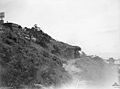
 View of Port Kembla from Hill 60 Park looking North West at sunset | |||||||||||||||
 Port Kembla | |||||||||||||||
| Coordinates | 34°28′32″S 150°54′01″E / 34.47556°S 150.90028°E | ||||||||||||||
| Population | 5,014 (2016 census)[1] | ||||||||||||||
| Postcode(s) | 2505 | ||||||||||||||
| Elevation | 19 m (62 ft) | ||||||||||||||
| Time zone | AEST (UTC+10) | ||||||||||||||
| • Summer (DST) | AEDT (UTC+11) | ||||||||||||||
| Location |
| ||||||||||||||
| LGA(s) | City of Wollongong | ||||||||||||||
| State electorate(s) | Wollongong | ||||||||||||||
| Federal division(s) | Whitlam | ||||||||||||||
| |||||||||||||||
History edit
Before Port Kembla was an industrial suburb of Wollongong, it was a town with a remarkably self-sufficient society, a growing commercial centre, and a vibrant civic life. Town subdivision began in 1908, and by 1921 there were 1622 residents.[3] Economic expansion propelled further population growth. Port Kembla derives its name from its proximity to Mount Kembla.
Industrial change edit
A copper smelter and refinery, the Electrolytic Refinery and Smelting Company of Australia, began production in 1908, followed by the opening of Metal Manufactures in 1917 and finally the arrival of the Hoskins Iron & Steel Works in 1927. The works became Australian Iron & Steel the following year.
By 1947 the town's population had increased to 4,960 with smaller satellite suburbs such as Cringila and Lake Heights, mushrooming on its fringes.[4] That year, 1947, marked the climax of a local campaign for municipal autonomy which was ultimately thwarted by the creation of a Greater City of Wollongong. In the post-Second World War period there was an inexorable decline of a 'Port Kembla' society as local town boundaries were slowly but surely absorbed into a more Wollongong-focused or regional identity.[5]
Cultural diversity edit
Despite the decline from the heyday of the 1920s, the town experienced major social and demographic change in the 1950s and 1960s. Waves of migrants, mostly from the United Kingdom, Italy, Macedonia and Germany, moved to the town. During this period, Port Kembla was on the cusp of changes affecting Australian society generally as new ethnic and cultural influences found a place in local society.[6] With its long migration history accommodating waves of migrant workers and their families, Port Kembla is still one of the most culturally diverse suburbs in New South Wales.
Hill 60 edit
Port Kembla's highest point, Hill 60, overlooks the Five Islands and Red Point. Hill 60, originally the site of an Aboriginal settlement, was used by the army during World War II to make a coastal gun emplacement known as Illowra Battery. In September 1942, Aboriginal inhabitants were forcibly evicted from the area.[7] It has remained in public ownership and is now a public lookout reserve, despite a vigorous campaign to return some of the land to its Aboriginal owners. Although not technically open to tourists, the tunnels are open, and can be explored by foot. The entrance to the tunnels is located almost under the coastguard tower on Hill 60, and can be seen down the left when standing at the information board, facing southeast.[8]
-
 Dated: 1944 No. 2 gun Illowra Battery, Showing its original BL 6 inch Mk XI gun
 -
 Gun position No. 2 at Illowra Battery, which formed part of the Kembla Fortress defences in World War II


HMAS Adele loss edit
On 7 May 1943, Australian steamer Adele struck the breakwater at Port Kembla and was subsequently declared a total loss.[9] The wreck of Adele is protected under the New South Wales Heritage Act, 1977.[10]
Union Protests edit
Port Kembla was the site of the Dalfram Dispute in 1938, where unionised dockworkers refused to load pig iron onto a ship heading for Japan after the Nanking Massacre. In 1974, a green ban was placed by the Builders Labourers Federation against high rise development and for the reclamation of the beach to be made a parkland.[11]
The Jobs for Women campaign won the right for women to work at the Port Kembla steelworks. The campaign won a historic court case under the Anti-Discrimination Act and set a precedent for the employment of women in non-traditional areas of work and the interpretation of direct and indirect discrimination.
Heritage listings edit
Port Kembla has a number of heritage-listed sites, including:
Population edit
According to the 2016 census of Population, there were 5,014 people in Port Kembla.
- Aboriginal and Torres Strait Islander people made up 3.7% of the population.
- 66.6% of people were born in Australia. The next most common countries of birth were Macedonia 9.0%, Italy 2.9% and England 2.0%.
- 66.3% of people spoke only English at home. Other languages spoken at home included Macedonian 14.7% and Italian 3.9%.
- The most common responses for religion were Catholic 26.8%, No Religion 21.5%, Eastern Orthodox 14.9% and Anglican 10.4%.[1]
Climate edit
Port Kembla has a warm oceanic climate (Cfb) with humid summers and mild, crisp winters. The suburb enjoys abundant sunshine, getting 111.4 clear days, annually.
| Climate data for Port Kembla (1957–1976) | |||||||||||||
|---|---|---|---|---|---|---|---|---|---|---|---|---|---|
| Month | Jan | Feb | Mar | Apr | May | Jun | Jul | Aug | Sep | Oct | Nov | Dec | Year |
| Record high °C (°F) | 41.9 (107.4) |
36.1 (97.0) |
39.4 (102.9) |
32.5 (90.5) |
29.4 (84.9) |
25.6 (78.1) |
25.8 (78.4) |
28.3 (82.9) |
35.0 (95.0) |
35.0 (95.0) |
39.2 (102.6) |
39.8 (103.6) |
41.9 (107.4) |
| Mean daily maximum °C (°F) | 24.1 (75.4) |
24.4 (75.9) |
24.1 (75.4) |
22.4 (72.3) |
19.4 (66.9) |
17.5 (63.5) |
16.7 (62.1) |
17.3 (63.1) |
19.2 (66.6) |
20.7 (69.3) |
22.4 (72.3) |
23.4 (74.1) |
21.0 (69.8) |
| Mean daily minimum °C (°F) | 18.4 (65.1) |
18.7 (65.7) |
18.0 (64.4) |
15.7 (60.3) |
12.7 (54.9) |
10.9 (51.6) |
9.8 (49.6) |
10.3 (50.5) |
11.8 (53.2) |
13.7 (56.7) |
15.3 (59.5) |
17.1 (62.8) |
14.4 (57.9) |
| Record low °C (°F) | 13.3 (55.9) |
13.0 (55.4) |
10.6 (51.1) |
10.0 (50.0) |
5.6 (42.1) |
5.3 (41.5) |
1.1 (34.0) |
2.2 (36.0) |
2.2 (36.0) |
7.2 (45.0) |
9.2 (48.6) |
10.0 (50.0) |
1.1 (34.0) |
| Average precipitation mm (inches) | 116.1 (4.57) |
157.5 (6.20) |
183.7 (7.23) |
92.9 (3.66) |
89.0 (3.50) |
140.3 (5.52) |
62.6 (2.46) |
87.7 (3.45) |
55.0 (2.17) |
108.0 (4.25) |
94.3 (3.71) |
90.4 (3.56) |
1,260.6 (49.63) |
| Average precipitation days | 11.6 | 12.5 | 13.4 | 9.1 | 8.0 | 9.7 | 7.4 | 9.5 | 8.2 | 11.2 | 11.1 | 11.0 | 122.7 |
| Average relative humidity (%) | 75 | 76 | 74 | 68 | 62 | 61 | 57 | 57 | 61 | 67 | 67 | 72 | 67 |
| Source: [13] | |||||||||||||
Industry and Infrastructure edit
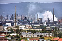
Port Kembla is known for the BlueScope steelworks operations on Springhill Road and throughout North Port Kembla. Other notable industrial operations in the suburb are: Port Kembla Coal Terminal, Port Kembla Copper, Incitec, Adstream Services, Port Kembla Gateway and GrainCorp.
Rail edit
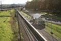
Port Kembla has a railway station on the Port Kembla branch of the Illawarra railway line. It is the terminus of the branch line, and serves the residential area of the suburb of the same name. The station has one side platform, used for terminating trains. It is served by approximately one train per hour, usually a local service to Thirroul and Waterfall, but extra direct trains to and from Sydney are provided in the peak hours.
Pacific National operates daily coal trains to the Inner Harbour section of the port, and into the blast furnace section of the steelworks. Downer Rail has a workshop opposite the station that services diesel powered locomotives for Pacific National.
Port edit
Port Kembla harbour is a major export location for coal mined in the southern and western regions of New South Wales. As part of the state governments plan to divert ships containing automobiles, the port has received significant upgrades and infrastructure including a new Maritime Office and many jobs have been created as the need for port logistics grows.[14] Patrick Corporation holds a contract for integrated port services in the harbour and transports goods by road or rail through its parent company Pacific National.
The port has a range of berths for loading coal, grain,[15] shipping containers and other goods. As of 2020, a gas export terminal is also under development.[16]

Port Kembla was identified by the Australian Defence Department in 2023 as the most likely location to homeport the future Australian nuclear-powered submarines, probably active no earlier than the 2030s.[17]
Sports and leisure edit
Sporting teams edit
Port Kembla has both junior and senior teams in local popular sporting leagues such as:
- Port Kembla Rugby League in the Illawarra Division Rugby league
Home grounds are Noel Mulligan Oval
- Port Kembla Cricket Club in the Cricket Illawarra Competition
Home grounds are King George V Park
- Port Kembla Soccer Club in the Illawarra Football Association
Home grounds are Darcy Wentworth Park
- Port Kembla AFL Club plays in South Coast AFL and AFL Illawarra
Home grounds are Kully Bay Park.
Port Kembla Rugby league, Port Kembla Soccer Club and Port Kembla AFL home grounds are not located in Port Kembla, they all play in parks across Warrawong.
Parks and beaches edit
Port Kembla has a number of parks, nature reserves, beaches and a Saltwater Olympic pool:
- King George V Park
A foreshore park located in walking distance from Port Kembla Beach. Used in summer for Port Kembla Cricket Club home games.
- Hill 60 Park
A popular take off area for hang gliders and para gliders, Hill 60 Park has BBQ facilities as well as picnic shelters, seats and tables positioned to enjoy the scenic views.
- Port Kembla Beach (Or Perkins Beach)
An award winning beach,[18] seasonally patrolled from September to April[19] and home to the Port Kembla Surf Life Saving Club. It's beach code is nsw379A[20] and it has a Surf Life Saving Australia general hazard rating of 7/10 [20]
- Fishermans Beach
A small sheltered beach at the bottom of Hill 60's eastern side facing the Five Islands Nature Reserve.
- North Port Kembla Beach
Also known by locals as MM Beach for its close proximity to the Metal Manufacturers site on Gloucester Boulevard. Remnants of a tidal rock pool are still standing near the southern end of the beach below the headland.
Three people died after being washed into rough surf at the popular rock fishing spot on Friday 22 January 2021.[21]
Public transport edit
Train edit
Port Kembla has two railway stations on the Port Kembla branch of the NSW TrainLink South Coast Line.
Port Kembla railway station is the terminus of the branch line, and serves the residential area of Port Kembla. Port Kembla North serves the industrial area of the suburb. The station is the nearest to the BHP site in the area.
Both stations have a one sided platform, with the platform at Port Kembla used for terminating trains. The stations are served by approximately one train per hour, usually a local service to Thirroul, but extra direct trains to and from Sydney are provided in the peak hours.

Bus edit
Premier Illawarra runs three routes to and from Port Kembla railway station:[22]
- 34 – to Wollongong via Berkeley
- 43 – to Dapto
- 65 – to North Beach
Health and environmental issues edit
Port Kembla chimney stack edit
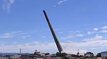
Port Kembla was home to one of Australia's tallest industrial chimneys, a 198 metre tall chimney built in 1965. Port Kembla Primary School was once located adjacent to it but was closed down due to pollution problems from the chimney including lead contaminated soil, acid rain and soot. A warning alarm was fitted to warn of high toxin levels. In November 2008, the Port Kembla stack was inspected and confirmed to have concrete cancer.[23] The stack was planned to be demolished in early 2010 at a cost of A$10 million.
By 6 September 2010, plans to knock down the stack had been revised by the NSW Department of Planning. These plans included demolition of the existing Port Kembla Copper structures surrounding the chimney, excluding the locally heritage listed Precious Metals Mill Chimney and the Assay Offices. The work was due to start in the middle of 2011 with a team of 30 workers, under supervision by NSW Police, NSW WorkCover and relevant emergency services at a cost of A$8 million with an expected time frame of 16 months.[24]
On 2 August 2013, it was announced that the stack would be demolished on Friday 6 September 2013.[25] Due to asbestos concerns, the demolition was delayed. After no signs of danger were found, a new date was announced for the demolition: 20 February 2014.[26]
On 20 February 2014, the copper stack was demolished.[27]
Industrial pollution edit

In the past, Port Kembla's industrial heart was associated with significant industrial pollution including emissions of nitrogen oxides and other dangerous gases. However, the air quality around Port Kembla has improved dramatically over the past decade. At nearby Kembla Grange the average concentration of nitrogen dioxide (NO2) measured by the NSW Department of Environment Climate Change halved between 2002 and 2014.[28]
Back in the 1990s health problems were associated with noxious gases. One 1998 study of the industrial areas of Newcastle and Port Kembla found 'an important association between relatively low levels of particulate air pollution and respiratory symptoms' among primary school children.[29] Fallout has also introduced elevated levels of lead and other heavy metals to the soil around Port Kembla and has formed thick deposits in many buildings and industrial structures.[30]
References edit
- ^ a b Australian Bureau of Statistics (27 June 2017). "Port Kembla (State Suburb)". 2016 Census QuickStats. Retrieved 16 July 2017.
 Material was copied from this source, which is available under a Creative Commons Attribution 4.0 International License.
- ^ "PLACE NAMES". The Australian Women's Weekly. National Library of Australia. 13 May 1964. p. 61. Retrieved 22 February 2011.
- ^ Commonwealth Census of Australia, 1921
- ^ Commonwealth Census of Australia, 1947
- ^ See Erik Eklund, Steel Town: the making and breaking of Port Kembla, pp.131-136
- ^ Erik Eklund, Steel Town: the making and breaking of Port Kembla, pp. 158-171
- ^ See Erik Eklund, 'Steel Town: the making and breaking of Port Kembla', MUP, Melbourne, 2002, pp. 114-130
- ^ [1] Archived 20 November 2009 at the Wayback Machine
- ^ "NEW SOUTH WALES SHIPWRECKS". Encyclopedia of Australian Shipwrecks. Archived from the original on 2 October 2009. Retrieved 10 October 2009.
- ^ "Adele (+1943)". Wrecksite. Retrieved 10 October 2009.
- ^ "List of green bans, 1971-1974". libcom.org. Retrieved 2 October 2019.
- ^ "Hill 60/ Illowra Battery". New South Wales State Heritage Register. Department of Planning & Environment. H01492. Retrieved 18 May 2018. Text is licensed by State of New South Wales (Department of Planning and Environment) under CC-BY 4.0 licence.
- ^ "Climate statistics for Port Kembla". Bureau of Meteorology. Retrieved 2 June 2016.
- ^ "Port Kembla | NSW Ports". www.nswports.com.au. Retrieved 3 November 2020.
- ^ "OUR PORTS". Quattro Ports. Retrieved 15 December 2020.
- ^ "NSW fast-tracks Port Kembla gas terminal". Energy Magazine. 17 September 2020. Retrieved 15 December 2020.
- ^ Nuclear submarine deal will deeply impact the Australian Defence Force. Has the government got it right?, ABC News, 13 March 2023, retrieved 22 March 2023.
- ^ Thompson, Angela (5 December 2009). "It's official: Port Kembla's the best beach in NSW - Local News - News - General". Illawarra Mercury. Retrieved 26 May 2012.
- ^ "Beaches". Wollongong.nsw.gov.au. Retrieved 26 May 2012.
- ^ a b "Port Kembla - Beach in Port Kembla Wollongong NSW". SLS Beachsafe. Retrieved 25 August 2020.
- ^ Just horrendous': Three people drown after being knocked into surf at Port Kembla 9News 23 January 2021
- ^ Berkeley, Warrawong & Port Kembla District timetable Premier Illawarra
- ^ Illawarra Mercury, 26 November 2008.
- ^ PORT KEMBLA CHIMNEY STACK TO BE DEMOLISHED NSW Government 6 September 2010
- ^ Humphries, Glen (2 August 2013). "Demolition day named for Port Kembla stack". Illawarra Mercury. Retrieved 24 October 2013.
- ^ "Port Kembla stack's finally coming down". Illawarra Mercury. Retrieved 31 December 2013.
- ^ "Thousands watch Port Kembla Copper stack demolition". ABC News. Retrieved 21 February 2014.
- ^ "NSW Department of Environment Climate Change: Annual Averages NO2 at Kembla Grange". Archived from the original on 13 March 2015. Retrieved 13 January 2015.
- ^ Peter R Lewis et al, (1998) 'Outdoor air pollution and children's respiratory symptoms in the steel cities of New South Wales', Medical Journal of Australia, 169: pp. 459-463 See [2]
- ^ "Case study: The Port Kembla Community's Dilemma with Toxic Dust". Lead.org.au. Retrieved 26 May 2012.
External links edit
- Australia's Tallest Industrial Chimney – Sightseeing with Google Satellite Maps
- PKC Stack Felling