


Summary
The Pocantico River is a nine-mile-long (14 km) tributary of the Hudson River in western central Westchester County, New York, United States. It rises from Echo Lake, in the town of New Castle south of the hamlet of Millwood, and flows generally southwest past Briarcliff Manor to its outlet at Sleepy Hollow. Portions of the towns of Mount Pleasant and Ossining are within its 16-square-mile (41 km2) watershed.
| Pocantico River | |
|---|---|
 The Pocantico as it flows through Rockefeller State Park | |
| Location | |
| Country | United States |
| State | New York |
| Region | Hudson Valley |
| County | Westchester |
| City | New Castle, Briarcliff Manor, Mount Pleasant, Sleepy Hollow, |
| Physical characteristics | |
| Source | Echo Lake |
| • location | New Castle |
| • coordinates | 41°10′48.2″N 73°48′36.2″W / 41.180056°N 73.810056°W[1] |
| • elevation | 325 ft (99 m)[2] |
| Mouth | Hudson River |
• location | Sleepy Hollow |
• coordinates | 41°5′29.5″N 73°52′12.9″W / 41.091528°N 73.870250°W |
| Length | 9 mi (14 km) |
| Discharge | |
| • location | Rockefeller State Park[3] |
| • average | 37.19 cu ft/s (1.053 m3/s) |
| • minimum | 15 cu ft/s (0.42 m3/s)[3] |
| • maximum | 77.3 cu ft/s (2.19 m3/s)[3] |
| Basin features | |
| Tributaries | |
| • left | Rockefeller Brook |
| • right | Caney Brook, Gory Brook |
Writer Washington Irving, who lived in the area for most of his life, was inspired by the undeveloped area above the river's mouth to write his classic "The Legend of Sleepy Hollow". Later in the 19th century much of the land was purchased by the Rockefeller family as part of their Kykuit estate; today much of that land has become Rockefeller State Park Preserve. A former reservoir used by the city of New Rochelle has likewise been converted into county-run Pocantico Lake Park. While the river runs predominantly through those parks and suburban land,[4] it is still one of the most polluted tributaries of the Hudson.[5]
Course edit
In the past the Pocantico was considered to have two different sources, but today it is acknowledged that it rises from Echo Lake in the eponymous state park located in the town of New Castle between Saw Mill River Road (New York State Route 100) and the Taconic State Parkway, just southwest of the unincorporated hamlet of Millwood. The lake is 325 feet (99 m) above sea level, in a narrow valley between Cabin Ridge to the east and a similarly steep ridge on the west. Its surrounding terrain is primarily wooded and lightly developed outside of the two roads. The river begins at a dam on the lake's south end.[6][7]
Shortly after draining the lake, the Pocantico flows under Route 100, which it remains closely parallel to for the next few miles. About 1,200 feet (370 m) from its source, the stream crosses the town line from New Castle into neighboring Ossining, soon forming the boundary between that town and neighboring Mount Pleasant on its west. A short distance to the south, the river crosses back under Saw Mill River Road and receives its first tributary, the unnamed outlet of Campfire Lake to the northeast, as it, Route 100 and the North County Trailway diverge from the Taconic. The river, road and trail continue heading to the southwest as the Pocantico begins to form the Briarcliff Manor village line at the Chappaqua Road crossing.[7][8]
Another 1,200 feet south of that crossing, it recrosses Saw Mill River Road just north of where it merges with the Briarcliff–Peekskill Parkway (also State Route 9A). After flowing under the parkway, it passes just east of downtown Briarcliff Manor and then crosses Saw Mill River Road and the parkway again, meandering a little further to the east into residential neighborhoods, then turning south through the village's Jackson Road Park. After that it flows due south to the immediate east of the parkway, itself to the immediate east of a steep slope.[9]
After a slight swing east towards the Taconic, the river crosses under the parkway for the last time and continues on a more southwesterly course past 420-foot (130 m) Beech Hill into 164-acre (66 ha) Pocantico Lakes Park. It widens amid swampy areas on either side as it receives Caney Brook from the north and then becomes Pocantico Lake. Midway along the lake, the municipal boundary leaves the river, putting it entirely within the town of Mount Pleasant. The dam at the lake's south end is at 219 feet (67 m) above sea level, a loss of 106 feet (32 m) from the Pocantico's source at Echo Lake.[10][11]
From there, it flows southwestward again. At Old Sleepy Hollow Road it enters Rockefeller State Park Preserve, at over 1,400 acres (570 ha) the largest of the three protected areas the river flows through. The road continues to parallel it on the east as it turns south; on the west it is paralleled by the preserve's Pocantico River Trail, which follows it for a mile and a half (2.4 km).[12] All three cross under Phelps Way (State Route 117) and turn south.[13]
Within the preserve, the river meanders between hills amidst woodland interrupted by large clearings. Small stone bridges carry several of the preserve's trails across the river. About 600 feet (180 m) after entering the preserve, the Pocantico crosses into the village of Sleepy Hollow. A short distance to the south, it receives Rockefeller Creek from the Pocantico Hills to the east. It bends north, away from the road, to receive its last named tributary, Gory Brook, from the north, where it turns abruptly south again. After another quarter-mile (400 m) it crosses under the Old Croton Aqueduct, a National Historic Landmark (NHL), and leaves the preserve, continuing straight through a steep, narrow wooded ravine in a slightly southwesterly direction.[12]
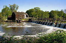
As it flows between Sleepy Hollow Cemetery to the west and the village's Douglas Park to the east, the river drops below 50 feet (15 m) in elevation. On the north edge of another residential neighborhood, it bends eastward. After flowing under U.S. Route 9, it is again impounded, creating the mill pond at the Philipsburg Manor House, another NHL.[14][15]
From that outlet, it meanders northwest past the former Tarrytown Truck Assembly plant, widening into a flood plain as it does. It bends north to pass another village park on the east, then north around that to divide the park from the residential area of Philipse Manor to its north. After flowing under the railroad tracks used by Metro-North's Hudson Line and Amtrak's Empire Service, it flows under the entrance road to the county's Kingsland Point Park and empties into the Hudson River.[14][15]
Watershed edit
The Pocantico's 16-square-mile (41 km2) watershed covers areas of Ossining, Mount Pleasant, and New Castle, including Briarcliff Manor and Sleepy Hollow.[16] It includes 436 acres (176 ha) of mapped freshwater wetlands and eleven dams. Approximately 14,866 people live within the watershed. It is largely suburban, but also contains parks, forests and wildlife, highways, utilities, and institutions.[17]
History edit

The Weckquaesgeek Native American tribe, who established their primary settlement around the mouth of a river in present-day Dobbs Ferry, also had a village at the mouth of the Pocantico River called Alipconck, meaning "place of elms".[20]: 11, 31 The river historically set the dividing line between Mount Pleasant and Ossining.[20]: 6
The river was once called by the English as "the Mill river", while the Native Americans called it Pocanteco, a derivative of the Algonquin term Pockóhantès, meaning a "run between two hills". The Dutch called it the Sleepy haven kill.[21]: 316 Dutch colonist Adriaen van der Donck's Beschrijvinge van Nieu Nederlandt, published in Amsterdam in 1655, referred to the Pocantico River as "Slapershaven" (Sleepers' Haven).[22] The anglicized term "Sleepy Hollow" grew to apply to the Pocantico's river valley and later to the village of North Tarrytown in particular; the village changed its official name to Sleepy Hollow in 1996.[23]
Frederick Philipse moved to the area and started purchasing land in the late 1600s, his properties would become known as Philipsburg Manor. He established his country seat at what was then known as North Tarrytown, at the mouth of the Pocantico River. A small community had already been established there when he arrived in 1683.[24]
A ship called the Roebuck, which transported cargo to and from New York City, ended up in the river, where its keel was scavenged by the miller at the mill of the Philipsburg Manor House site.[21]: 328
Around the late 1890s, Walter W. Law and Briarcliff Farms deepened the river for a length of 2 miles (3 km), taking out the rifts so the stream would flow and the swamps adjacent to the river would drain. The workers also cut rock and took out trees that lined the swamps to reclaim land for farming.[25]
The North Tarrytown Assembly, a large automobile factory in Sleepy Hollow, was owned and operated by General Motors for much of its history; a 1923 expansion of the facility involved land-filling the river; two-thirds of the factory site was land formerly occupied by the river. The river was rerouted south of the site.[26]
During 1999's Hurricane Floyd, the Pocantico was blocked by fallen trees and almost washed away the Philipsburg Manor historic site; about 70 employees of the parent organization Historic Hudson Valley assisted in its protection, along with the site's curators and security guards, and other village residents.[27]
Ecology and environment edit

The organization Riverkeeper collects samples in three Pocantico River tributaries. The river downstream of Pocantico Lake is a habitat for brown trout.[4][28] The river is stocked each spring; 540 brown trout were stocked in 2013, and 630 were anticipated to be stocked in the river in 2014.[29][30] After a bacteria test completed on October 4, 2014, the river was found to have an Enterococcus bacteria count of greater than 2420, indicating high amounts of fecal matter in the water.[4] Other tests of the river quality at the mouth of the river in Sleepy Hollow also contain high levels of Enterococcus bacteria. In fact, the high bacteria counts throughout the river were taken both after wet and dry weather.[4] Dry weather tends to result in lower bacteria counts because less flooding results in less overflow from sewage treatment plants.[31] The high levels of bacteria in the river resulted in beach advisories for the entire river.[4] In 2014, $9.9 million was put aside to repair the Tarrytown sewage treatment plant in order to improve water quality in the region.[32]
A Westchester County water quality study of the Pocantico River found that the chemical pollutants in the water met most of New York State Standards. The river met state standards on nitrate and phosphate levels, resulting in little cultural eutrophication in the water. Dissolved oxygen levels also met state standards with an average concentration of 9.853 milligrams per liter. Only the conductivity of the water failed state standards with conductivity levels averaging about three times the recommended levels.[3]
American eels enters the river from the Hudson every spring, moving upstream over the course of one to three years. The eels often accumulate under a dam in Sleepy Hollow, and approximately 10% make it past the dam. The eels move upstream where the habitat is preferable, with lower polychlorinated biphenyl pollution, fewer parasites, faster growth rates for the eels, and a higher percentage of females in the population. Other species in the river include white perch, white sucker, yellow perch, golden shiner, and alewife, only in small numbers.[33]
Adjacent to the river is a protected area known as Pocantico Lake Park. The park contains hiking trails as well as an abandoned water treatment plant from the New Rochelle Water Company.[34][35] Nearby land fronting Pocantico Lake was purchased by a housing developer in 2020; local residents subsequently began a campaign to prevent the land from being used for more housing and protect the environment, including its supply of fresh water, and wildlife.[36][37][38][39] As of 2023, a number of residents had pointed out flaws in the draft environmental impact statement.[40]
In popular culture edit

The dénouement of "The Legend of Sleepy Hollow" is set at a bridge over the Pocantico River in the area of the Old Dutch Church and Burying Ground in Sleepy Hollow.[42][b] As well, Washington Irving makes frequent mention of the Pocantico River in Chronicle III of his short story anthology Wolfert's Roost.[43]
The delighted historian pursued his explorations far into the foldings of the hills where the Pocantico winds its wizard stream among the mazes of its old Indian haunts; sometimes running darkly in pieces of woodland beneath balancing sprays of beech and chestnut: sometimes sparkling between grassy borders in fresh green intervals; here and there receiving the tributes of silver rills which came whimpering down the hill sides from their parent springs. In a remote part of the Hollow, where the Pocantico forced its way down rugged rocks, stood Carl's mill, the haunted house of the neighborhood.
— Washington Irving, Wolfert's Roost, Chronicle III[43]
See also edit
Notes edit
- ^ The mill was described as a ruin in 1899.[18]
- ^ The bridge is presumed to be part of the Albany Post Road, now part of U.S. Route 9; at least five bridges are known to have stood there.[42]
References edit
- ^ U.S. Geological Survey Geographic Names Information System: Pocantico River, USGS GNIS
- ^ U.S. Geological Survey Geographic Names Information System: Echo Lake
- ^ a b c d Mulligan, Gerard E. "Westchester County Citizens' Volunteer Monitoring Program Water Quality Report 2004" (PDF). www.westchestergov.com/. Westchester County Department of Planning. Archived from the original (PDF) on November 2, 2014. Retrieved November 2, 2014.
- ^ a b c d e "Pocantico River". Riverkeeper. Retrieved April 25, 2014.
- ^ Risinit, Michael (March 29, 2014). "Pocantico River, Sparkill Creek flunk water purity test". The Journal News. Retrieved April 25, 2014.
- ^ Ossining Quadrangle – New York – Westchester Co (Map). 1:24,000. USGS 7 1/2-minute quadrangle maps. U.S. Geological Survey. Retrieved November 9, 2014.
- ^ a b N 41.17224 W 73.81638 (Map). Acme Mapper. Retrieved October 31, 2014.
- ^ Ossining Quadrangle – New York – Westchester Co (Map). 1:24,000. USGS 7 1/2-minute quadrangle maps. U.S. Geological Survey. Retrieved November 9, 2014.
- ^ Ossining Quadrangle – New York – Westchester Co (Map). 1:24,000. USGS 7 1/2-minute quadrangle maps. U.S. Geological Survey. Retrieved November 9, 2014.
- ^ White Plains Quadrangle – New York – Westchester Co (Map). 1:24,000. USGS 7 1/2-minute quadrangle maps. U.S. Geological Survey. Retrieved November 9, 2014.
- ^ N 41.17224 W 73.81638 (Map). Acme Mapper. Retrieved October 31, 2014.
- ^ a b Rockefeller State Park Preserve Trail Map (PDF) (Map). Cartography by NYSOPRHP GIS Bureau. New York State Office of Parks, Recreation and Historic Preservation. May 29, 2014. Retrieved November 10, 2014.
- ^ White Plains Quadrangle – New York – Westchester Co (Map). 1:24,000. USGS 7 1/2-minute quadrangle maps. U.S. Geological Survey. Retrieved November 10, 2014.
- ^ a b White Plains Quadrangle – New York – Westchester Co (Map). 1:24,000. USGS 7 1/2-minute quadrangle maps. U.S. Geological Survey. Retrieved November 10, 2014.
- ^ a b N 41.17224 W 73.81638 (Map). Acme Mapper. Retrieved October 31, 2014.
- ^ "Pocantico River". Sleepy Hollow Environmental Advisory Council. 26 November 2009. Retrieved October 31, 2014.
- ^ "Pocantico River Watershed Overview 9/2014" (PDF). Hudson River Watershed Alliance. Retrieved October 31, 2014.
- ^ Bacon, Edgar Mayhew (October 14, 1899). "Irving and Paulding. When They Were Boys-Tarrytown and Sleepy Hollow" (PDF). The New York Times. Retrieved November 6, 2014.
- ^ "Museum Collections: Carl's Mill, Tarrytown, New York". New-York Historical Society. Archived from the original on November 1, 2014. Retrieved November 1, 2014.
- ^ a b Scharf, John Thomas (1886). History of Westchester Country, New York. Philadelphia: L. E. Preston & Co.
- ^ a b Bolton, Jr., Robert (1848). A History of the County of Westchester, From its First Settlement to the Present Time. New York: Alexander S. Gould. Retrieved October 31, 2014.
- ^ Hall, Edward Hagaman (1912). Philipse Manor Hall at Yonkers, N. Y. New York City, New York: The American Scenic and Historic Preservation Society. p. 34.
- ^ Steiner, Henry. "History of the Village". Village of Sleepy Hollow. Retrieved October 31, 2014.
- ^ Richard Greenwood (March 31, 1976). "National Register of Historic Places Inventory-Nomination: Dutch Reformed (Sleepy Hollow) Church" (pdf). National Park Service.
- ^ Strong, Josiah; Tolman, William Howe (January 1901). "Christmas Eve at Briarcliff Farms". Social Service. 3 (1): 8–22. Retrieved February 28, 2015.
- ^ "General Motors Site Redevelopment, Sleepy Hollow". Riverkeeper, Inc. Retrieved November 1, 2014.
- ^ "Neighbors Wade In to Save Old Manor". The New York Times. September 21, 1999. Retrieved November 6, 2014.
- ^ "Rockefeller State Park Preserve". New York State Office of Parks, Recreation and Historic Preservation. Retrieved October 31, 2014.
- ^ "2013 Fish Stocking in Westchester County". New York State Department of Environmental Conservation. Retrieved October 31, 2014.
- ^ "Spring 2014 Trout Stocking for Westchester County". New York State Department of Environmental Conservation. Retrieved October 31, 2014.
- ^ Rubin, Debra K. "Flooded Sewage Plants Seek Ways to Keep Pumps Running in the Next Storm". newyork.construction.com/. ENR New York. Retrieved November 2, 2014.
- ^ Valenti, Ken (July 7, 2014). "Hudson River report: Swimmers need info before wading in". The Journal News. Retrieved November 2, 2014.
- ^ Schmidt, Robert E. "Migratory Fishes in the Pocantico River" (PDF). Hudson River Watershed Alliance. Retrieved October 31, 2014.
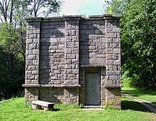
- ^ "The New Rochelle Water Company Ruins at Pocantico Lake in Mount Pleasant, NY". Roadside Ruins. Retrieved 2022-08-25.
- ^ "Pocantico Lake County Park". Scenes From The Trail. 2020-04-19. Retrieved 2022-08-25.
- ^ Seaman, Barrett (2022-07-10). "County Weighs Bid for Disputed Pocantico Lake Property". The Hudson Indy Westchester's Rivertowns News -. Retrieved 2022-08-25.
- ^ "Save Pocantico Lake". Retrieved 2022-08-25.
- ^ Wilbur, Martin (2021-08-24). "Pocantico Lake Residents Gear Up for Development Fight". Retrieved 2022-08-25.
- ^ "Pocantico Lake Project Faces Fierce Opposition". Retrieved 2022-08-25.
- ^ "Residents Highlight Flaws in DEIS Pocantico Lake Proposal". 2023-02-08. Retrieved 2023-02-14.
- ^ "No 'Rockefeller' on Bridge" (PDF). The New York Times. August 8, 1912. Retrieved October 31, 2014.
- ^ a b "The Headless Horseman Bridge". The Sleepy Hollow Cemetery. The Sleepy Hollow Cemetery Historic Fund. Archived from the original on April 26, 2014. Retrieved April 26, 2014.
- ^ a b Irving, Washington (1865). Wolfert's Roost and Other Papers, Now First Collected. New York: G. P. Putnam's Sons. Retrieved November 1, 2014.
External links edit
- Pocantico Lake on OpenStreetMap
- Westchester County government map of the river and its watershed
- Mentions of The Pocantico in Wolfert's Roost
- The Pocantico River Watershed Conservancy