


Summary
Northumberland County is an upper-tier municipality situated on the north shore of Lake Ontario, east of Toronto in Central Ontario. The Northumberland County headquarters are located in Cobourg.
Northumberland County | |
|---|---|
| County of Northumberland | |
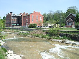
Clockwise from top: Downtown Campbellford from the Trent River, farmland in the Municipality of Trent Hills, downtown Port Hope from the Ganaraska River, downtown Colborne. | |
 Location of Northumberland County within Ontario | |
| Coordinates: 44°07′N 78°02′W / 44.117°N 78.033°W | |
| Country | |
| Province | |
| County seat | Cobourg |
| Municipalities | List
|
| Government | |
| • Type | Upper-tier municipal government |
| • Warden | Mandy Martin[1] |
| • Governing body | Northumberland County Council |
| Area | |
| • Total | 1,905.15 km2 (735.58 sq mi) |
| Population (2021)[2] | |
| • Total | 89,365 |
| • Density | 47.78/km2 (123.7/sq mi) |
| Time zone | UTC−05:00 (EST) |
| • Summer (DST) | UTC−05:00 (EDT) |
| Website | www.northumberlandcounty.ca |


Municipalities edit
Northumberland County consists of seven municipalities:
| Municipality | Population (2021)[2] | Area[2] | Population density[2] | Major population centres |
|---|---|---|---|---|
| Town of Cobourg | 20,519 | 22.41 | 915.7 | |
| Municipality of Port Hope | 17,294 | 278.8 | 62.0 | Port Hope |
| Municipality of Trent Hills | 13,861 | 513.85 | 27.0 | Campbellford, Warkworth, Hastings |
| Municipality of Brighton | 12,108 | 223.24 | 54.2 | Brighton |
| Township of Hamilton | 11,059 | 256.03 | 43.2 | |
| Township of Alnwick/Haldimand | 7,473 | 398.25 | 18.8 | |
| Township of Cramahe | 6,509 | 202.22 | 32.2 | Colborne |
The Alderville First Nation is geographically located within the County and is a part of the Northumberland census division, but, as an Indian reserve, it is independent of county administration.
History edit
The County was first established in 1792, and was organized alongside neighbouring Durham County into the Newcastle District of Upper Canada in 1802.[3] The County was initially settled by a mix of Irish, Scottish, and English immigrants, as well as by Americans immigrating north from New England.[3]
In 1850, the Newcastle District was reorganized into the United Counties of Northumberland and Durham, an arrangement which lasted until 1973. Effective January 1, 1974, the majority of Durham County was amalgamated with Ontario County to create the Regional Municipality of Durham. The Township of Hope and the Town of Port Hope were transferred to Northumberland, which reverted to a standalone county.
Recreation edit

There are two provincial parks in Northumberland County: Presqu'ile Provincial Park in Brighton, and Ferris Provincial Park in Campbellford.[4] There are also several other protected natural areas and forests, including Ganaraska Forest,[5] Northumberland County Forest, Goodrich-Loomis Conservation Area, and Peter's Woods. Waterfront campsites and cottages are located along Lake Ontario and Rice Lake.
Northumberland County has various cycling, hiking and other outdoor trails. The Waterfront Trail along Lake Ontario passes through Northumberland County,[6] as does the Trans-Canada Trail.[7] The Northumberland portion of the Trans-Canada Trail spans from Hastings to Hoard's Station in Campbellford, following an abandoned rail line. Halfway through Campbellford, the trail joins the 6 km long Rotary Trail situated alongside the Trent River. There are five signed bike routes: Glorious Ganaraska, Rice Lake Ramble, Shelter Valley, Presqu’ile Promise and Trent River Truckin'.[8] The Northumberland County Forest offers various trails available for hiking, cycling, horseback riding, ATVing, off-road motorcycling, cross-country skiing, snowmobiling, snowshoeing[9] as well as a 3.2 km, accessible Universal Trail.[10] The Ganaraska Hiking Trail starts in Port Hope and goes north towards the Bruce Trail.[11]
There are three theatres in Northumberland County: Westben in Campbellford, the Capitol Theatre in Port Hope, and the Park Theatre & Performing Arts Centre in Cobourg.[12] Festivals in Northumberland include the Warkworth Maple Syrup and Float Your Fanny Down the Ganny festivals in early spring, the Cobourg Sandcastle Festival and Incredible Edibles Festival in the summer, and the Cultivate Food and Vintage Film Festivals in the fall.[13]
Demographics edit
As a census division in the 2021 Census of Population conducted by Statistics Canada, Northumberland County had a population of 89,365 living in 37,328 of its 40,638 total private dwellings, a change of 4.4% from its 2016 population of 85,598. With a land area of 1,907.4 km2 (736.5 sq mi), it had a population density of 46.9/km2 (121.3/sq mi) in 2021.[14]
| 2021 | 2016 | 2011 | |
|---|---|---|---|
| Population | 89,365 (+4.4% from 2016) | 85,598 (4.2% from 2011) | 82,126 (1.4% from 2006) |
| Land area | 1,907.40 km2 (736.45 sq mi) | 1,905.15 km2 (735.58 sq mi) | 1,905.34 km2 (735.66 sq mi) |
| Population density | 46.9/km2 (121/sq mi) | 44.9/km2 (116/sq mi) | 43.1/km2 (112/sq mi) |
| Median age | 52.4 (M: 50.8, F: 54) | 51.4 (M: 50.3, F: 52.4) | |
| Private dwellings | 37,330 (total) | 39,032 (total) | 37,226 (total) |
| Median household income | $70,208 |
| Year | Pop. | ±% |
|---|---|---|
| 1996 | 74,437 | — |
| 2001 | 77,497 | +4.1% |
| 2006 | 80,963 | +4.5% |
| 2011 | 82,126 | +1.4% |
| 2016 | 85,598 | +4.2% |
| 2021 | 89,365 | +4.4% |
| [20][19][21][22] 1996 population adjusted to 2001 boundaries | ||
| Panethnic group |
2021[23] | 2016[24] | 2011[25] | 2006[26] | 2001[27] | |||||||||
|---|---|---|---|---|---|---|---|---|---|---|---|---|---|---|
| Pop. | % | Pop. | % | Pop. | % | Pop. | % | Pop. | % | |||||
| European[a] | 80,305 | 92.01% | 78,215 | 93.82% | 75,835 | 95.23% | 75,710 | 95.75% | 73,210 | 96.41% | ||||
| Indigenous | 3,095 | 3.55% | 2,275 | 2.73% | 1,885 | 2.37% | 1,630 | 2.06% | 1,420 | 1.87% | ||||
| African | 925 | 1.06% | 835 | 1% | 355 | 0.45% | 380 | 0.48% | 380 | 0.5% | ||||
| East Asian[b] | 810 | 0.93% | 690 | 0.83% | 460 | 0.58% | 495 | 0.63% | 540 | 0.71% | ||||
| South Asian | 715 | 0.82% | 495 | 0.59% | 400 | 0.5% | 310 | 0.39% | 100 | 0.13% | ||||
| Southeast Asian[c] | 545 | 0.62% | 320 | 0.38% | 250 | 0.31% | 195 | 0.25% | 65 | 0.09% | ||||
| Latin American | 245 | 0.28% | 200 | 0.24% | 150 | 0.19% | 105 | 0.13% | 85 | 0.11% | ||||
| Middle Eastern[d] | 240 | 0.27% | 80 | 0.1% | 85 | 0.11% | 95 | 0.12% | 65 | 0.09% | ||||
| Other[e] | 400 | 0.46% | 250 | 0.3% | 210 | 0.26% | 145 | 0.18% | 65 | 0.09% | ||||
| Total responses | 87,280 | 97.67% | 83,365 | 97.39% | 79,635 | 96.97% | 79,070 | 97.66% | 75,940 | 97.99% | ||||
| Total population | 89,365 | 100% | 85,598 | 100% | 82,126 | 100% | 80,963 | 100% | 77,497 | 100% | ||||
| Note: Totals greater than 100% due to multiple origin responses | ||||||||||||||
See also edit
Notes edit
- ^ Statistic includes all persons that did not make up part of a visible minority or an indigenous identity.
- ^ Statistic includes total responses of "Chinese", "Korean", and "Japanese" under visible minority section on census.
- ^ Statistic includes total responses of "Filipino" and "Southeast Asian" under visible minority section on census.
- ^ Statistic includes total responses of "West Asian" and "Arab" under visible minority section on census.
- ^ Statistic includes total responses of "Visible minority, n.i.e." and "Multiple visible minorities" under visible minority section on census.
References edit
- ^ "Meet Your Council". Northumberland County. Retrieved August 11, 2023.
- ^ a b c d e "Census Profile, 2021 Census: Northumberland, County". Statistics Canada. Retrieved August 5, 2019.
- ^ a b Barry Stratow. "The Stories of the Counties of Ontario: Northumberland". ElectricCanadian.com. Retrieved August 12, 2023.
- ^ "Provincial Park Locator". Ontario Parks. Retrieved 22 November 2017.
- ^ "Ganaraska Forest". Ganaraska Conservation. Ganaraska Region Conservation Authority. Retrieved 22 November 2017.
- ^ "Interactive Map". Waterfront Trail. Retrieved 22 November 2017.
- ^ "Explore The Map". The Great Trail. Retrieved 22 November 2017.
- ^ "Cycling Routes and Trails". Northumberland Tourism. 2018-05-03. Retrieved 2018-07-11.
- ^ "Forest Trails". northumberlandcounty.ca. Retrieved 2018-08-24.
- ^ "Universal Trail". northumberlandcounty.ca. Retrieved 2018-08-24.
- ^ "Trail Sections". Ganaraska Hiking Trail. Retrieved 22 November 2017.
- ^ "Arts and Culture". Northumberland Arts and Culture. Retrieved 2018-07-11.
- ^ "Northumberland Festivals | NorthumberlandNews.com". www.northumberlandnews.com. Retrieved 2018-07-11.
- ^ "Population and dwelling counts: Canada and census divisions". Statistics Canada. February 9, 2022. Retrieved April 2, 2022.
- ^ "2021 Community Profiles". 2021 Canadian Census. Statistics Canada. February 4, 2022. Retrieved 2022-04-27.
- ^ "2016 Community Profiles". 2016 Canadian Census. Statistics Canada. August 12, 2021. Retrieved 2019-08-05.
- ^ "2011 Community Profiles". 2011 Canadian Census. Statistics Canada. March 21, 2019. Retrieved 2012-03-22.
- ^ "2006 Community Profiles". 2006 Canadian Census. Statistics Canada. August 20, 2019.
- ^ a b "2001 Community Profiles". 2001 Canadian Census. Statistics Canada. July 18, 2021.
- ^ Statistics Canada: 1996, 2001, 2006, 2011
- ^ "Northumberland County census profile". 2011 Census of Population. Statistics Canada. Retrieved 2012-03-22.
- ^ "Census Profile, 2016 Census: Northumberland, County". Statistics Canada. Retrieved August 5, 2019.
- ^ Government of Canada, Statistics Canada (2022-10-26). "Census Profile, 2021 Census of Population". www12.statcan.gc.ca. Retrieved 2023-03-01.
- ^ Government of Canada, Statistics Canada (2021-10-27). "Census Profile, 2016 Census". www12.statcan.gc.ca. Retrieved 2023-03-01.
- ^ Government of Canada, Statistics Canada (2015-11-27). "NHS Profile". www12.statcan.gc.ca. Retrieved 2023-03-01.
- ^ Government of Canada, Statistics Canada (2019-08-20). "2006 Community Profiles". www12.statcan.gc.ca. Retrieved 2023-03-01.
- ^ Government of Canada, Statistics Canada (2019-07-02). "2001 Community Profiles". www12.statcan.gc.ca. Retrieved 2023-03-01.
External links edit
- Official website