


Summary
The Naturita Formation is a classification used in western Colorado and eastern Utah for a Cretaceous Period sedimentary geologic formation. This name was "applied to the upper or carbonaceous part of Dakota Group" by R.G. Young in 1960, naming it for Naturita, Colorado.[1] The name is not used by U.S. Geological Survey authors,[2] but has found growing acceptance by the Utah Geological Survey[3][4][5]
| Naturita Formation | |
|---|---|
| Stratigraphic range: Cenomanian ~ | |
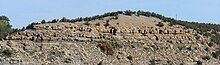
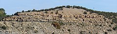 Type locality for the Naturita Formation above the former Nucla coal power plant, Naturita, Colorado | |
| Type | Geological formation |
| Sub-units | Culver Coal Zone member |
| Underlies | Mancos Shale |
| Overlies | Cedar Mountain & Burro Canyon Formations |
| Lithology | |
| Primary | Mudstone |
| Other | Shale, sandstone |
| Location | |
| Coordinates | 37°36′N 112°54′W / 37.6°N 112.9°W |
| Approximate paleocoordinates | 39°24′N 75°30′W / 39.4°N 75.5°W |
| Region | Colorado, Utah |
| Country | United States |
| Type section | |
| Named for | Naturita, Colorado |
 Naturita Formation (the United States)  Naturita Formation (Utah) | |
History of the name edit
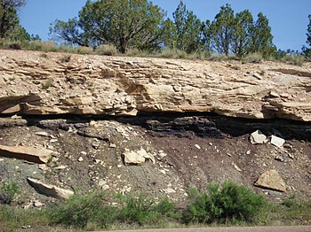
A coal seam is visible below its sandstone bed, with a thin volcanic ash (white) layer in its upper portion.
The formation in Utah and western Colorado overlies the Cedar Mountain and Burro Canyon Formations, and underlies the Mancos Shale formation, thus occupying a similar position of sedimentary strata that have widely[6] been called Dakota Formation in Iowa, Kansas and Nebraska. [7]
The use of the name "Dakota" in western states was the result of early geological mapping by F.V. Hayden beginning in the 1850. For convenience, he maintained the same terminology developed during the early mapping along the Missouri River as he began mapping farther west in the 1860s even while acknowledging "There are very few points of resemblance between these beds and those which form the Dakota group, as seen in Kansas and Nebraska. All the evidence therefore that I have had to guide me in regard to these beds along the margin of the mountain ranges has been their position."[8] (p. 114). Despite this doubt by Hayden, the name Dakota Formation became entrenched in many western states, but has been renamed as the Lakota Formation in South Dakota, the Cloverly Formation in Wyoming and Montana (in part), and the South Platte Formation in eastern Colorado, but not on the northern half of the Colorado Plateau where the name "Dakota Formation" continued to be used.
In 1960, Young who was investigating uranium ore deposits on the Colorado Plateau for the U.S. Atomic Energy Commission, proposed the name Naturita Formation for the town of Naturita, Colorado. Although he described the general character of the formation,[1] he did not designate a type section until five years later.[9] The proposed name change was ignored by most geologists, probably because Young did not elaborate why he was proposing a name change. Years later, Witzke and Ludvigson independently noted a problem with the use of the name "Dakota Formation" in western states, writing "Usage of the term 'Dakota' for western-derived sedimentary sequences in the Rocky Mountain area is discouraged."[7]. This, too was largely ignored until Carpenter made a detailed case for accepting "Naturita Formation" on the Colorado Plateau.[10] After a detailed review of the history of the problem, Carpenter argued 1) that during their deposition, the Dakota Formation and the Naturita Formation were separated by the Western Interior Cretaceous Seaway, 2) stream depositing the Dakota and Naturita Formations were flowing towards each other on opposite sides of the Seaway, but the formations did not connect one side of the seaway to the other, and 3) sediments of the Dakota Formation on the east side of the Seaway were derived from the North American Craton, whereas sediments of the Naturita Formation were derived from the Sevier uplift along the Nevada-Utah border. Thus, the two formations were derived independent of each other.
Geology edit
The formation is described as having a lower section that is dark-brown to black, carbonaceous claystone, gray shale, and siltstone, and some beds of gray-orange to white coarse-grained sandstone which may form ledges; a middle section of mostly thin, but locally thick coal beds; and an upper section that is gray-orange to light brown, moderately erosion resistant, locally fossiliferous sandstone that is interbedded with light-olive-gray shale. Locally, a channel conglomerate is present at the base.[4] Where missing, a lag of conglomerate may be present indicating winnowing of sediments, which occurred by advancing Cretaceous seas. In other places, deposition of Naturita sediments did not occur, and these areas may have been quiet lagoons because oyster shells are often present in great abundance.
The lower portion of the Naturita Formation represents river channel and floodplain deposits, whereas the upper part represent a complex of estuarine, lagoonal, and swamp environments of a coastal plain.[3]
Ludvigson and Witzke,[11] correlated the Dakota Formation in Iowa with the "Dakota" along the Colorado Front Range based on palynostratigraphy and recognized those palynostratigraphic sequences throughout the Western Interior. In 2012, the Dakota/Naturita Formation sequence and fossil pollen species in Utah were correlated with the Ludvigson and Witzke report on the Dakota at the Nebraska type location.[12]
Radiometric dates and fossil invertebrates show that the Naturita Formation becomes progressively younger southwards and westwards across Utah, thus recording the advancing Western Interior Seaway.[10]
Fossil content edit
Plants edit
A low diversity flora assemblage has been described from Utah consisting of horsetails, ferns and angiosperms.[13] Many of the identifications are dated and a new study may increase the diversity.
Equisetum
Asplenium
Coniopteris
Hausmannia
Gleichenia
Matonidium
Astralopteris
Cladophlebis
Ilex
Magnolia
Ficus
Eucalyptus
Platanus
Salix
Vertebrates edit
Fossi vetebrates include dinosaur bone fragments of ceratopsians, a possible primitive tyrannosaurid, nodosaurid ankylosaurs, a brachiosaurid sauropod, the bothremyid turtle Paiutemys.[14][15] and fossil mammals
Mammals edit
- Cedaromys minimus
- Cimolodon cf. similis
- Dakotadens morrowi
- Dakotamys malcolmi
- Eoalphadon clemensi
- E. lillegraveni
- E. woodburnei
- Paracimexomys cf. robisoni
- Pariadens kirklandi
- Varalphadon janetae
- Alphadon sp.
- Bryceomys sp.
- Dakotadens sp.
- Eoalphadon sp.
- Paracimexomys sp.
- Protalphadon sp.
See also edit
References edit
- ^ a b Young, R.G., 1960, Dakota Group of Colorado Plateau: Bulletin of the American Association of Petroleum Geologists, v. 44, no. 2, p. 156-194.
- ^ "Geologic Unit: Naturita". National Geologic Database. Geolex — Significant Publications. United States Geological Survey. Retrieved 2021-02-22.
[Geolex indicates that no U.S. Geological Survey authors have used the name.]
- ^ a b "Geologic map of the Kanarraville quadrangle, Iron County, Utah" (PDF). Utah Geological Survey. Retrieved July 22, 2022.
- ^ a b "Interim Geologic Map of the Escalante 30' x 60' Quadrangle, Garfield and Kane Counties, Utah" (PDF). Utah Geological Survey. Retrieved July 22, 2022.
- ^ "Geologic Map of the Panguitch 30'X 60' Quadrangle, Garfield, Iron and Kane Counties, Utah" (PDF). Utah Geological Survey. Retrieved July 22, 2022.
- ^ "Geologic Unit: Dakota". National Geologic Database. Geolex — Significant Publications. United States Geological Survey. Retrieved 2021-02-22.
- ^ a b Witzke, B.J., and Ludvigson, G.A., 1994, The Dakota Formation in Iowa and the type area, in Shurr, G.W., Ludvigson, G.A., and Hammond, R.H, editors, Perspectives on the eastern margin of the Cretaceous Western Interior Basin: Geological Society of America Special Paper, v. 287, p. 43-78.
- ^ Hayden, F.V., 1869, Third annual report: United States Geological and Geographical Survey of the Territories, embracing Colorado and New Mexico, 155 p.
- ^ Young, R.G. 1965. Type section of the Naturita Formation. Bulletin of the American Association of Petroleum Geologists 49:1512-1516.
- ^ a b Carpenter, K., 2014. Where the sea meets the land—the unresolved Dakota problem in Utah. Utah Geological Association Publication, 43, pp.357-372.
- ^ Greg A. Ludvigson, Brian J. Witzke (2010). "New Insights on the Sequence Stratigraphic Architecture of the Dakota Formation in Kansas–Nebraska–Iowa from a Decade of Sponsored Research Activity". Current Research in Earth Sciences: Palynostratigraphy and Correlation of the Dakota Formation in the Type Area, Iowa, Nebraska, and Kansas. Retrieved March 16, 2021.
- ^ Douglas A. Sprinkel, Scott K. Madsen, James I. Kirkland, Gerald L. Waanders, and Gary J. Hunt (2012). "Cedar Mountain and Dakota Formations around Dinosaur National Monument—evidence of the first incursion of the Cretaceous Western Interior Seaway into Utah" (PDF). Utah Geological Survey Special Study (143). Utah Geological Survey. Retrieved February 21, 2021.
The Dakota Formation ... has undergone a colorful history of nomenclature changes. ... Naturita has generally not been an accepted name for this section of rocks on the Colorado Plateau. ... The term Dakota Sandstone has been formally used in geologic maps and reports in the eastern Uinta Mountains (...); however, we revise the descriptive term to formation to reflect the lithologic heterogeneity of the Dakota in this region and to be consistent with usage elsewhere in Utah.
{{cite journal}}: CS1 maint: multiple names: authors list (link) - ^ Rushforth, Samuel R. (1971). "A flora from the Dakota sandstone formation (Cenomanian) near Westwater, Grand County, Utah". Brigham Young University Science Bulletin, Biological Series. Retrieved July 22, 2022.
- ^ Carpenter, K. 2006. Assessing dinosaur faunal turnover in the Cedar Mountain Formation (Lower Cretaceous) of eastern Utah, USA. Ninth International Symposium on Mesozoic Terrestrial Ecosystems and Biota, Abstract and Proceedings Volume, p. 21-25
- ^ Joyce WG, Lyson TR, Kirkland JI. (2016) An early bothremydid (Testudines, Pleurodira) from the Late Cretaceous (Cenomanian) of Utah, North America. PeerJ 4:e2502 https://doi.org/10.7717/peerj.2502