


Summary
McKees Rocks, also known as "The Rocks", is a borough in Allegheny County in Western Pennsylvania, United States, along the south bank of the Ohio River. Part of the Pittsburgh metropolitan area, its population was 5,920 at the time of the 2020 census.[2]
McKees Rocks, Pennsylvania | |
|---|---|
 Chartiers Avenue in McKees Rocks, Pennsylvania | |
| Etymology: Alexander McKee | |
| Nickname: The Rocks | |
 Location in Allegheny County and the state of Pennsylvania. | |
| Coordinates: 40°28′12.79″N 80°3′49.22″W / 40.4702194°N 80.0636722°W | |
| Country | |
| State | |
| County | Allegheny |
| Settled in 1764 | Incorporated in 1892 |
| Area | |
| • Total | 1.12 sq mi (2.90 km2) |
| • Land | 1.06 sq mi (2.73 km2) |
| • Water | 0.06 sq mi (0.16 km2) |
| Population | |
| • Total | 5,920 |
| • Density | 5,606.06/sq mi (2,164.60/km2) |
| Time zone | UTC-5 (EST) |
| • Summer (DST) | UTC-4 (EDT) |
| ZIP code | 15136 |
| Area code | 412 |
| Exchanges | 331, 771, 777, 778 |
| FIPS code | 42-46264 |
| School district | Sto-Rox |
| Website | McKees Rocks |
The borough is within the Sto-Rox School District, which serves McKees Rocks and neighboring Stowe Township. The local high school is Sto-Rox High School.
The Pittsburgh, Allegheny and McKees Rocks Railroad is located in an area along the river known as the "Bottoms".
The McKees Rocks Bridge, which carries traffic between McKees Rocks and Pittsburgh, is the longest bridge in Allegheny County, at 7,293 feet (2,223 m). McKees Rocks has one of the largest Indian mounds in the state, built by the Adena and Hopewell peoples a thousand years before Europeans entered the area.
In the past, the city was known for its extensive iron and steel interests. There were large railroad machine shops and manufacturers of locomotives and freight and passenger cars. Other factories produced springs, enamel ware, lumber, wall materials, plaster, nuts and bolts, malleable castings, chains and forgings, tin ware, concrete, and cigars.
McKees Rocks is also known as the birthplace of former Ohio Governor John Kasich and late television salesperson Billy Mays.
History edit
For thousands of years, Native Americans inhabited the region. The Adena culture built a large earthwork mound here, which was a burial site. It was augmented in later years by members of the Hopewell culture. This was the largest such mound in the state.[3] The Carnegie Museum of Natural History excavated half the mound in 1896. Its archaeologists traced the construction history and unearthed the remains of 33 people. The mound crowned a high bluff that overlooks Chartiers Creek and the Ohio River. The bluff under the mound was quarried for municipal paving some time after the archaeological dig, eliminating what remained of the Indian burial site. This site was considered by George Washington as a possible location for Fort Pitt, which he eventually ordered built on the site of the destroyed French Fort Duquesne in what is now Pittsburgh's Point State Park.[4]
Around 1749, the French-Canadian explorer Pierre Joseph Celoron de Blainville visited the area and discovered a "written rock" inscribed with markings he believed were made by Native Americans. Celeron named the place after the rock, and it eventually became known as McKees Rocks. Writing in 1918, historian John Boucher stated that the inscriptions had "long since faded away, if indeed they were anything other than marks made by English fur traders."[5]
The borough derives its name from trader Alexander McKee, who also served as an Indian agent. He was given a 1,300-acre (530 ha) tract of land in 1764 for his services during the French and Indian War. The name also related to a rocky projection into the river at this site. In 1769, the name McKees Rocks was placed on an official deed,[6] and that year is considered to be its founding date.[7] In 1892, it was incorporated as a borough.[7] In 1900, 6,353 people resided in the borough; in 1910, 14,702; in 1920, 16,713; and in 1940, 17,021 people inhabited McKees Rocks. After industrial restructuring caused a loss of jobs in the city, the population declined, to 6,104 at the 2010 census.
Mann's Hotel, which was possibly one of the oldest buildings in the Pittsburgh area,[8] was located at 23 Singer Avenue in McKees Rocks. It was believed to have been built around 1803, although some sources put the construction in the 18th century.[8] It is rumored that George Washington stayed there[8] when he was surveying the Indian mound. On October 12, 2009, Mann's Hotel was condemned due to neglect and had to be demolished because of its deteriorating condition.[9][8]
McKees Rocks was the site of one of the pivotal labor conflicts of the early 20th century, the 1909 McKees Rocks Strike. In the summer and early fall of 1909, some 5,000 workers of the Pressed Steel Car Company's plant at McKees Rocks went on strike, joined by 3,000 others who worked for the Standard Steel Car Company of Butler and others in New Castle.[10] The strike, led by organizers of the Industrial Workers of the World (IWW), was repressed by armed security guards and the state militia, resulting in at least a dozen deaths. The conflict involved participants on both sides.[11]
In 1940, three decapitated bodies were found in boxcars in McKees Rocks during a routine train inspection. The train cars had apparently come from Youngstown. In fact, throughout the 1920s, various dismembered and decapitated bodies were recovered in or around the nearby swamp areas of New Castle and McKees Rocks.[12] Despite similarities to a series of murders that had occurred in Cleveland during the same time period, the murders were never solved or officially connected to the killings in Ohio.[13][14]
Geography edit
McKees Rocks is located at 40°28′13″N 80°3′49″W / 40.47028°N 80.06361°W (40.470218, −80.063674).[15]
According to the United States Census Bureau, the borough has a total area of 1.1 square miles (2.8 km2), of which 1.0 square mile (2.6 km2) is land and 0.1 square miles (0.26 km2), or 6.31%, is water.
Points of interest edit
The multimillion-dollar, 40,000 sq ft (3,700 m2) Father Ryan Cultural Arts Center opened in 2008, at 420 Chartiers Avenue, adjacent to the F.O.R. Sto-Rox Library (at 500 Chartiers Avenue). It offers many creative and performing arts courses to the public.[citation needed]
The "Bottoms" neighborhood is the site of the McKees Rocks Indian Mound, designated as a National Historic Landmark.[16] The oldest human bones in eastern North America have been discovered here during an excavation.[citation needed]
Surrounding and adjacent neighborhoods edit
McKees Rocks is made up of several neighborhoods, such as West Park, Meyers Ridge, and "The Bottoms". McKees Rocks has two borders by land: Kennedy Township to the west and Stowe Township to the north. Chartiers Creek separates McKees Rocks from two Pittsburgh neighborhoods and have connectors to both:
- Windgap to the southwest via Windgap Bridge. However, this is not a direct connection as a very small border of Kennedy Township separates the two communities in the middle of the bridge.
- Esplen to the south and southeast via Linden Ave. Bridge
Across the Ohio River, McKees Rocks runs adjacent to two other Pittsburgh neighborhoods:
- Brighton Heights to the northeast via McKees Rocks Bridge. As with Windgap, this is not a direct connection as Stowe Township separates the two neighborhoods in the middle of the bridge.
- Marshall-Shadeland to the southeast and under the east end of the bridge
Demographics edit
| Census | Pop. | Note | %± |
|---|---|---|---|
| 1890 | 1,687 | — | |
| 1900 | 6,352 | 276.5% | |
| 1910 | 14,702 | 131.5% | |
| 1920 | 16,713 | 13.7% | |
| 1930 | 18,116 | 8.4% | |
| 1940 | 17,021 | −6.0% | |
| 1950 | 16,241 | −4.6% | |
| 1960 | 13,185 | −18.8% | |
| 1970 | 11,901 | −9.7% | |
| 1980 | 8,742 | −26.5% | |
| 1990 | 7,691 | −12.0% | |
| 2000 | 6,622 | −13.9% | |
| 2010 | 6,104 | −7.8% | |
| 2020 | 5,920 | −3.0% | |
| Sources:[17][18][19][20][21][2] | |||
| Year | Republican | Democratic | Third parties |
|---|---|---|---|
| 2020 | 32% 726 | 65% 1,462 | 1% 35 |
| 2016 | 31% 703 | 66% 1,504 | 3% 61 |
| 2012 | 23% 524 | 76% 1,724 | 1% 20 |
As of the 2000 census,[18] there were 6,622 people, 2,905 households, and 1,652 families residing in the borough. The population density was 6,377.5 inhabitants per square mile (2,462.4/km2). There were 3,402 housing units at an average density of 3,276.4 per square mile (1,265.0/km2). The racial makeup of the borough was 82.71% White, 14.06% African American, 0.26% Native American, 0.68% Asian, 0.03% Pacific Islander, 0.41% from other races, and 1.86% from two or more races. Hispanic or Latino of any race were 1.09% of the population.
The 2010 census revealed there were 6,104 residents. The population density was 6003.25 people per square mile. The racial makeup was 62.17% White, 35.26% African American, 0.57% Asian, and 0.34% from other races. Hispanic or Latino of any race were 1.65% of the population.
There were 2,905 households, out of which 26.0% had children under the age of 18 living with them, 29.4% were married couples living together, 21.3% had a female householder with no husband present, and 43.1% were non-families. 37.8% of all households were made up of individuals, and 17.2% had someone living alone who was 65 or older. The average household size was 2.24 and the average family size was 2.96.
The population included 24.1% under the age of 18, 7.8% from 18 to 24, 28.3% from 25 to 44, 20.9% from 45 to 64, and 19.0% who were 65 or older. The median age was 38. For every 100 females, there were 89.1 males; for every 100 females age 18 and over, there were 84.2 males.
The median income for a household in the borough was $22,278, and the median income for a family was $29,063. Males had a median income of $25,872 versus $23,402 for females. The per capita income for the borough was $13,858. About 20.5% of families and 25.3% of the population were below the poverty line, including 38.8% of those under age 18 and 17.0% of those age 65 or over.
Notable people edit


- Myron Brown, Slippery Rock University basketball star and NBA player[citation needed]
- Tom Clements, quarterbacks coach of the Green Bay Packers[citation needed][25]
- Chuck Fusina, Penn State, USFL, and NFL football player[citation needed]
- Damar Hamlin, NFL player for the Buffalo Bills
- John Kasich, 69th Governor of Ohio from 2011 to 2019, former Congressman, and presidential candidate in 2000 and 2016[26]
- Catherine Baker Knoll, 30th Lieutenant Governor of Pennsylvania (2003–2008)[27]
- Carl Kosak, author[citation needed]
- Al Kozar, Major League Baseball infielder[28]
- Ted Kwalick, Penn State all-America football player and San Francisco 49ers all-Pro tight end; member of the College Football Hall of Fame[citation needed]
- Bob Ligashesky, special teams coordinator for the Syracuse Orange
- Billy Mays, television pitchman and Oxi-Clean spokesman, known for his bearded face and distinct voice.[29]
- Roman Macek, former American football player and pro wrestler under the ring name Luca Crusifino[30]
- Alex Sandusky (1932–2020), professional football player[31]
- Jeff Smith, cartoonist, best known as the creator of the self-published comic book series Bone[32]
- Paul Spadafora, former IBF world lightweight boxing champion, known as the "Pittsburgh Kid"[33]
- Olive Thomas, silent film actress, and the original flapper[34]
In popular culture edit
McKees Rocks is the fictional setting of the novels Duffy's Rocks by Edward Fenton, Riot by William Trautmann, and more than a dozen novels by the crime writer K. C. Constantine.[citation needed]
See also edit
Gallery edit
-
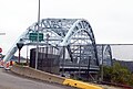 The McKees Rocks Bridge from Island Avenue
 -
 Another view of the McKees Rocks Bridge
 -
 Mancini's Bakery (since 1926)
 -
 McKees Rocks Mound historical marker
 -
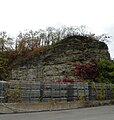 "The Rocks" of McKees Rocks
 -


References edit
- ^ "ArcGIS REST Services Directory". United States Census Bureau. Retrieved October 12, 2022.
- ^ a b c "Census Population API". United States Census Bureau. Retrieved October 12, 2022.
- ^ Agreen, Bernadette Sulzer; Society, McKees Rocks Historical (2009). McKees Rocks and Stowe Township. Arcadia Publishing. ISBN 978-0-7385-6471-5.
- ^ Part I
- ^ Boucher, John N. (1918). Old and New Westmoreland, Volume 1. The American Historical Society, Inc. p. 9.
- ^ "Q & A". mckeesrocks.com. Archived from the original on August 10, 2007.
- ^ a b "Welcome".
- ^ a b c d Torsten Ove, "Historic Mann's Hotel will become history", Pittsburgh Post-Gazette, Saturday, August 08, 2009.
- ^ Pittsburgh History & Landmarks Foundation, "Historic Mann's Hotel Demolished", PHLF News, October 12, 2009.
- ^ Louis Duchez, "The Strikes in Pennsylvania," The International Socialist Review, vol. 10, no. 3 (September 1909), pp. 194-195.
- ^ Marylynne Pitz, "Pressed Steel Car strike in McKees Rocks reaches centennial anniversary," Pittsburgh Post-Gazette, August 16, 2009, p. E1.
- ^ "They Called it the Murder Swamp | Psychology Today".
- ^ Gibson, Dirk Cameron (2004). Clues from Killers: Serial Murder and Crime Scene Messages. Greenwood Publishing Group. ISBN 978-0-275-98360-4.
- ^ "Myths, legends and hauntings of McKees Rocks". Gazette 2.0. October 28, 2020. Retrieved April 18, 2022.
- ^ "US Gazetteer files: 2010, 2000, and 1990". United States Census Bureau. February 12, 2011. Retrieved April 23, 2011.
- ^ "McKees Rocks Mound Historical Marker". explorepahistory.com. Retrieved July 30, 2020.
- ^ "1990 Population and Housing Counts". US Census Bureau. Retrieved November 22, 2013.
- ^ a b "U.S. Census website". United States Census Bureau. Retrieved January 31, 2008.
- ^ "Race, Hispanic or Latino, Age, and Housing Occupancy: 2010 Census Redistricting Data (Public Law 94-171) Summary File (QT-PL), McKees Rocks borough, Pennsylvania". United States Census Bureau. Retrieved September 20, 2011.
- ^ "Number of Inhabitants: Pennsylvania" (PDF). 18th Census of the United States. U.S. Census Bureau. Retrieved November 22, 2013.
- ^ "Annual Estimates of the Resident Population". U.S. Census Bureau. Archived from the original on November 20, 2013. Retrieved November 22, 2013.
- ^ EL. "2012 Allegheny County election". Pittsburgh Tribune-Review. Retrieved October 15, 2017.
- ^ EL. "2016 Pennsylvania general election results". Pittsburgh Post-Gazette. Retrieved October 15, 2017.
- ^ "Election Night Reporting".
- ^ Kansas City hires Tom Clements as quarterbacks coach[verification needed]
- ^ Henry J. Gomez (May 12, 2014) A mailman's son in McKees Rocks dreams of priesthood and politics: John Kasich 5.0 Cleveland.com
- ^ "IN MEMORIAL OF PENNSYLVANIA LIEUTENANT GOVERNOR CATHERINE BAKER KNOLL". govinfo.gov. November 20, 2008. Retrieved October 25, 2021.
- ^ "Al Kozar Stats". Baseball-Reference.com. Retrieved September 11, 2018.
- ^ Stacy, Mitch (June 28, 2009). "TV pitchman Billy Mays found dead". FOX Toledo.com. TVL Broadcasting, Inc. Retrieved June 28, 2009.
- ^ "Luca Crusifino". The Smackdown Hotel.
- ^ "Alex Sandusky," Pro Football Reference.com, www.pro-football-reference.com/
- ^ Biography: Jeff Smith Archived 2009-03-16 at the Wayback Machine. Scholastic. Retrieved July 23, 2013.
- ^ "Paul Spadafora". BoxRec.
- ^ "Olive Thomas, the original 'Flapper' and a Mon Valley native, still fascinates". Pittsburgh Post-Gazette. Retrieved December 27, 2023.
External links edit
- Official website
- Community Development Corporation
- Sto-Rox School District