


Summary
Maya cities were the centres of population of the pre-Columbian Maya civilization of Mesoamerica. They served the specialised roles of administration, commerce, manufacturing and religion that characterised ancient cities worldwide.[1] Maya cities tended to be more dispersed than cities in other societies, even within Mesoamerica, as a result of adaptation to a lowland tropical environment that allowed food production amidst areas dedicated to other activities.[1] They lacked the grid plans of the highland cities of central Mexico, such as Teotihuacán and Tenochtitlan.[2] Maya kings ruled their kingdoms from palaces that were situated within the centre of their cities.[3] Cities tended to be located in places that controlled trade routes or that could supply essential products.[4] This allowed the elites that controlled trade to increase their wealth and status.[4] Such cities were able to construct temples for public ceremonies, thus attracting further inhabitants to the city.[4] Those cities that had favourable conditions for food production, combined with access to trade routes, were likely to develop into the capital cities of early Maya states.[4]

The political relationship between Classic Maya city-states has been likened to the relationships between city-states in Classical Greece and Renaissance Italy.[5] Some cities were linked to each other by straight limestone causeways, known as sacbeob, although whether the exact function of these roads was commercial, political or religious has not been determined.[6]
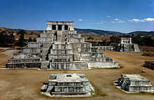
Architectural organization edit
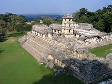
Maya cities were not formally planned like the cities of highland Mexico and were subject to irregular expansion, with the haphazard addition to all of the palaces, temples and other buildings.[7] Most Maya cities tended to grow outwards from the core, and upwards as new structures were superimposed upon preceding architecture.[8] Maya cities usually had a ceremonial and administrative centre surrounded by a vast irregular sprawl of residential complexes.[7] The centres of all Maya cities featured sacred precincts, sometimes separated from nearby residential areas by walls.[9] These precincts contained pyramid temples and other monumental architecture dedicated to elite activities, such as basal platforms that supported administrative or elite residential complexes.[10] Sculpted monuments were raised to record the deeds of the ruling dynasty.[10] City centres also featured plazas, sacred ballcourts and buildings used for marketplaces and schools.[10] Frequently causeways linked the centre to outlying areas of the city.[9] Some of these classes of architecture formed lesser groups in the outlying areas of the city, which served as sacred centres for non-royal lineages.[10] The areas adjacent to these sacred compounds included residential complexes housing wealthy lineages.[10] Art excavated from these elite residential complexes varies in quality according to the rank and prestige of the lineage that it housed.[10] The largest and richest of these elite compounds sometimes possessed sculpture and art of craftsmanship equal to that of royal art.[10]
The ceremonial centre of the Maya city was where the ruling elite lived, and where the administrative functions of the city were performed, together with religious ceremonies. It was also where the inhabitants of the city gathered for public activities.[7] Elite residential complexes occupied the best land around the city centre, while commoners had their residences dispersed further away from the ceremonial centre.[6] Residential units were built on top of stone platforms to raise them above the level of the rain season floodwaters.[6]
Population estimates edit
Until the 1960s, scholarly opinion was that the ruins of Maya centres were not true cities but were rather empty ceremonial centres where the priesthood performed religious rituals for the peasant farmers, who lived dispersed in the middle of the jungle.[11] Since the 1960s, formal archaeological mapping projects have revealed that the ceremonial centres in fact formed the centres of dispersed cities that possessed populations that at some sites could reach tens of thousands.[11]
| Site name | Location | Maximum population | Period |
|---|---|---|---|
| Coba | Quintana Roo, Mexico | 50,000[12] | Late Classic |
| Copán | Copán Department, Honduras | 15,000-21,000[13] | Late Classic |
| Calakmul | Campeche, Mexico | 50,000[14] | Late Classic |
| Caracol | Cayo District, Belize | 140,000[15] | Classic |
| Cival | Petén Department, Guatemala | 2,000-5,000[16] | Late Preclassic |
| El Pilar | Cayo District, Belize; Petén Department, Guatemala | 180,000[17] | Late Classic |
| Mixco Viejo (Jilotepeque Viejo) | Chimaltenango Department, Guatemala | 1,500[18] | Late Postclassic |
| Motul de San José | Petén Department, Guatemala | 1,200-2,000[19] | Late Classic |
| Quiriguá | Izabal Department, Guatemala | 1,200–1,600[13] | Late Classic |
| Qʼumarkaj | Quiché Department, Guatemala | 15,000[20] | Late Postclassic |
| Río Azul | Petén Department, Guatemala | 3,500[21] | Early Classic |
| Santa Rita, Corozal | Corozal District, Belize | 7,000[22] | Late Postclassic |
| Sayil | Yucatán, Mexico | 10,000[23] | Terminal Classic |
| Seibal | Petén Department, Guatemala | 10,000[13] | Late Preclassic |
| Tikal | Petén Department, Guatemala | 100,000[24] | Late Classic |
| Xunantunich | Cayo District, Belize | 10,000[25] | Terminal Classic |
History edit
Middle Preclassic Period edit
During the Middle Preclassic Period (1000-400 BC), small villages began to grow to form cities.[26] By 500 BC these cities possessed large temple structures decorated with stucco masks representing gods.[27] Nakbe in the Petén Department of Guatemala is the earliest well-documented city in the Maya lowlands,[28] where large structures have been dated to around 750 BC.[26] Nakbe already featured the monumental masonry architecture, sculpted monuments and causeways that characterised later cities in the Maya lowlands.[28]
Late Preclassic Period edit
In the Late Preclassic Period (400 BC - 250 AD), the enormous city of El Mirador grew to cover approximately 16 square kilometres (6.2 sq mi).[29] It possessed paved avenues, massive triadic pyramid complexes dated to around 150 BC, and stelae and altars that were erected in its plazas.[29] El Mirador is considered to be one of the first capital cities of the Maya civilization.[29] The swamps of the Mirador Basin appear to have been the primary attraction for the first inhabitants of the area as evidenced by the unusual cluster of large cities around them.[30]
The city of Tikal, later to be one of the most important of the Classic Period Maya cities, was already a significant city by around 350 BC, although it did not match El Mirador.[31] The Late Preclassic cultural florescence collapsed in the 1st century AD and many of the great Maya cities of the epoch were abandoned; the cause of this collapse is as yet unknown.[27]
In the highlands, Kaminaljuyu in the Valley of Guatemala was already a sprawling city by AD 300.[32]
Classic Period edit

During the Classic Period (AD 250-900), the Maya civilization achieved its greatest florescence.[27] During the Early Classic (AD 250-300), cities throughout the Maya region were influenced by the great metropolis of Teotihuacan in the distant Valley of Mexico.[33] At its height during the Late Classic, Tikal had expanded to have a population of well over 100,000.[24] Tikal's great rival was Calakmul, another powerful city in the Petén Basin.[34] In the southeast, Copán was the most important city.[34] Palenque and Yaxchilán were the most powerful cities in the Usumacinta region.[34] In the north of the Maya area, Coba was the most important Maya capital.[12] Capital cities of Maya kingdoms could vary considerably in size, apparently related to how many vassal cities were tied to the capital.[35] Overlords of city-states that held sway over a greater number of subordinate lords could command greater quantities of tribute in the form of goods and labour.[5] The most notable forms of tribute pictured on Maya ceramics are cacao, textiles and feathers.[5] During the 9th century AD, the central Maya region suffered major political collapse, marked by the abandonment of cities, the ending of dynasties and a northward shift of population.[33] During this period, known as the Terminal Classic, the northern cities of Chichen Itza and Uxmal show increased activity.[33] Major cities in Mexico's Yucatán Peninsula continued to be inhabited long after the cities of the southern lowlands ceased to raise monuments.[36]
Postclassic Period edit
The Postclassic Period (AD 900-c.1524) was marked by a series of changes that distinguished its cities from those of the preceding Classic Period.[37] The once-great city of Kaminaljuyu in the Valley of Guatemala was abandoned after a period of continuous occupation that spanned almost two thousand years.[38] This was symptomatic of changes that were sweeping across the highlands and neighbouring Pacific coast, with long-occupied cities in exposed locations relocated, apparently due to a proliferation of warfare.[38] Cities came to occupy more-easily defended hilltop locations surrounded by deep ravines, with ditch-and-wall defences sometimes supplementing the protection provided by the natural terrain.[38] Chichen Itza, in the north, became what was probably the largest, most powerful and most cosmopolitan of all Maya cities.[39] One of the most important cities in the Guatemalan Highlands at this time was Qʼumarkaj, also known as Utatlán, the capital of the aggressive Kʼicheʼ Maya kingdom.[37]
Conquest and rediscovery edit
The cities of the Postclassic highland Maya kingdoms fell to the invading Spanish conquistadors in the first half of the 16th century. The Kʼicheʼ capital, Qʼumarkaj, fell to Pedro de Alvarado in 1524.[40] Shortly afterwards, the Spanish were invited as allies into Iximche, the capital city of the Kaqchikel Maya.[41] Good relations did not last and the city was abandoned a few months later.[42] This was followed by the fall of Zaculeu, the Mam Maya capital, in 1525.[43] In 1697, Martín de Ursúa launched an assault upon the Itza capital Nojpetén and the last remaining independent Maya city fell to the Spanish.[44]
By the 19th century, the existence of five former Maya cities was known in the Petén region of Guatemala.[45] Nojpetén had been visited by Spanish conquistador Hernán Cortés in 1525,[46] followed by a number of missionaries at the beginning of the 17th century.[45] The city was finally razed when it was conquered in 1697.[45] Juan Galindo, governor of Petén, described the ruins of the Postclassic city of Topoxte in 1834.[45] Modesto Méndez, a later governor of Petén, published a description of the ruins of the once great city of Tikal in 1848.[45] Teoberto Maler described the ruins of the city of Motul de San José in 1895.[45] San Clemente was described by Karl Sapper in the same year.[45] The number of known cities grew enormously during the course of the 20th century, 24 cities in Petén alone had been described by 1938.[45]
Notes edit
- ^ Graham 2005, p.4.
- ^ Martin & Grube 2000, p.15.
- ^ a b c Martin & Grube 2000, p.21.
- ^ a b c Olmedo Vera 1997, p.35.
- ^ a b c Olmedo Vera 1997, p.34.
- ^ Miller 1999, p.25.
- ^ a b Schele & Mathews 1999, p.23.
- ^ a b c d e f g Schele & Mathews 1999, p.24.
- ^ a b Martin & Grube 2000, p.6.
- ^ Braswell et al. 2005, p.171.
- ^ UCF Anthropology 2014.
- ^ Estrada-Belli 2011, p.77.
- ^ Ford, Anabel; Nigh, Ronald (2018). Maya Forest Garden: Eight Millennia of Sustainable Cultivation of the Tropical Woodlands. Walnut Creek, California: Left Coast Press. p. 116. ISBN 9781611329988.
- ^ Arroyo 2001, p.42.
- ^ Foias 2014, p. 90.
- ^ Fox 1989, p.673.n2.
- ^ Sharer and Traxler 2006, p. 326.
- ^ Sharer & Traxler 2006, p.545.
- ^ Wilford, John Noble (5 October 1993). "Archeologists Wonder at a City That Survived the Maya Collapse". The New York Times.
- ^ a b Olmedo Vera 1997, p.26.
- ^ a b c Martin & Grube 2000, p.8.
- ^ a b c Olmedo Vera 1997, p.28.
- ^ Hansen et al. 2006, p.740.
- ^ Martin & Grube 2000, pp.25-26.
- ^ Demarest 2004, p. 75.
- ^ a b c Martin & Grube 2000, p.9.
- ^ a b c Olmedo Vera 1997, p.36.
- ^ Martin & Grube 2000, p.19.
- ^ Becker 2004, p.135.
- ^ a b Arroyo 2001, p.38.
- ^ Sharer & Traxler 2006, pp.764-765. Recinos 1952, 1986, pp.68, 74.
- ^ Schele & Mathews 1999, p.297. Guillemín 1965, p.9.
- ^ Schele & Mathews 1999, p.298.
- ^ Recinos 1952, 1986, p.110. del Águila Flores 2007, p.38.
- ^ Jones 1998, p. xix.
- ^ a b c d e f g h Quintana 2003, p.381.
- ^ Jones 2000, p. 358.
References edit
- Arroyo, Bárbara (July–August 2001). Enrique Vela (ed.). "El Poslclásico Tardío en los Altos de Guatemala" [The Late Postclassic in the Guatemalan Highlands]. Arqueología Mexicana (in Spanish). IX (50). Editorial Raíces: 38–43. ISSN 0188-8218.
- Becker, Marshall Joseph (2004). "Maya Heterarchy as Inferred from Classic-Period Plaza Plans". Ancient Mesoamerica. 15. Cambridge University Press: 127–138. doi:10.1017/S0956536104151079. S2CID 162497874.
- Braswell, Geoffrey E.; Gunn, Joel D.; Carrasco, Dominguez; del Rosario, María; Folan, William J.; Fletcher, Laraine A.; Morales López, Abel; Glascock, Michael D. (2005). "Defining the Terminal Classic at Calakmul, Campeche". In Demarest, Arthur A.; Rice, Prudence M.; Rice, Don S. (eds.). The Terminal Classic in the Maya lowlands: Collapse, transition, and transformation. Boulder: University Press of Colorado. pp. 162–194. ISBN 0-87081-822-8. OCLC 61719499.
- del Águila Flores, Patricia (2007). "Zaculeu: Ciudad Postclásica en las Tierras Altas Mayas de Guatemala" [Zaculeu: Postclassic City in the Maya Highlands of Guatemala] (PDF) (in Spanish). Guatemala: Ministerio de Cultura y Deportes. Archived from the original (PDF) on 2011-07-21. Retrieved 2011-02-25.
- Demarest, Arthur (2004). Ancient Maya: The Rise and Fall of a Forest Civilization. Cambridge, UK: Cambridge University Press. ISBN 978-0-521-53390-4. OCLC 51438896.
- Estrada-Belli, Francisco (2011). The First Maya Civilization: Ritual and Power Before the Classic Period. Abingdon, UK and New York, USA: Routledge. ISBN 978-0-415-42994-8. OCLC 614990197.
- Foias, Antonia E. (2014) [2013]. Ancient Maya Political Dynamics. Gainesville, Florida, US: University Press of Florida. ISBN 978-0-8130-6089-7. OCLC 878111565.
- Fox, John W. (September 1989). "On the Rise and Fall of Tuláns and Maya Segmentary States". American Anthropologist. New Series. 91 (3). Oxford/Arlington, VA: Blackwell Publishing on behalf of the American Anthropological Association: 656–681. doi:10.1525/aa.1989.91.3.02a00080. JSTOR 680872.
- Graham, Elizabeth (2005). "Maya cities and the character of a tropical urbanism" (PDF). Uppsala, Sweden: Uppsala University. Archived from the original (PDF) on 2016-03-05. Retrieved 2011-03-01.
- Guillemín, Jorge F. (1965). Iximché: Capital del Antiguo Reino Cakchiquel [Iximche: Capital of the Former Kaqchikel Kingdom] (in Spanish). Guatemala: Tipografía Nacional de Guatemala.
- Hansen, Richard D.; Balcárcel, Beatriz; Suyuc, Edgar; Mejía, Héctor E.; Hernández, Enrique; Valle, Gendry; Guenter, Stanley P.; Novak, Shannon (2006). J.P. Laporte; B. Arroyo; H. Mejía (eds.). "Investigaciones arqueológicas en el sitio Tintal, Petén" [Archaeological investigations at the site of Tintal, Peten] (PDF). XIX Simposio de Investigaciones Arqueológicas en Guatemala, 2005 (in Spanish). Museo Nacional de Arqueología y Etnología, Guatemala. pp. 739–751. Archived from the original (PDF online publication) on 2011-08-13. Retrieved 2011-08-19.
- Jones, Grant D. (1998). The Conquest of the Last Maya Kingdom. Stanford, California, USA: Stanford University Press. ISBN 9780804735223.
- Jones, Grant D. (2000). "The Lowland Maya, from the Conquest to the Present". In Richard E.W. Adams; Murdo J. Macleod (eds.). The Cambridge History of the Native Peoples of the Americas, Vol. II: Mesoamerica, part 2. Cambridge, UK: Cambridge University Press. pp. 346–391. ISBN 0-521-65204-9. OCLC 33359444.
- Martin, Simon; Nikolai Grube (2000). Chronicle of the Maya Kings and Queens: Deciphering the Dynasties of the Ancient Maya. London and New York: Thames & Hudson. ISBN 0-500-05103-8. OCLC 47358325.
- Miller, Mary Ellen (1999). Maya Art and Architecture. London and New York: Thames & Hudson. ISBN 0-500-20327-X. OCLC 41659173.
- Olmedo Vera, Bertina (1997). A. Arellano Hernández; et al. (eds.). The Mayas of the Classic Period. Mexico: Consejo Nacional para la Cultura y las Artes (National Council for Culture and the Arts). pp. 9–99. ISBN 970-18-3005-9. OCLC 42213077.
- Quintana, Oscar (2003). J.P. Laporte; B. Arroyo; H. Escobedo; H. Mejía (eds.). "Las ciudades Mayas del Noreste de Petén: Potencial plataforma para impulsar un desarrollo regional" [The Maya cities in Northeastern Peten: Potential platform for launching regional development] (PDF). XVI Simposio de Investigaciones Arqueológicas en Guatemala, 2002 (in Spanish). Guatemala City, Guatemala: Museo Nacional de Arqueología y Etnología. pp. 381–390. Archived from the original (PDF) on 2011-07-07. Retrieved 2011-02-23.
- Recinos, Adrian (1986) [1952]. Pedro de Alvarado: Conquistador de México y Guatemala [Pedro de Alvarado: Conqueror of Mexico and Guatemala] (in Spanish) (2nd ed.). Guatemala: CENALTEX Centro Nacional de Libros de Texto y Material Didáctico "José de Pineda Ibarra". OCLC 243309954.
- Schele, Linda; Peter Mathews (1999). The Code of Kings: The language of seven Maya temples and tombs. New York: Simon & Schuster. ISBN 978-0-684-85209-6. OCLC 41423034.
- Sharer, Robert J.; Loa P. Traxler (2006). The Ancient Maya (6th (fully revised) ed.). Stanford, CA: Stanford University Press. ISBN 0-8047-4817-9. OCLC 57577446.
- UCF Anthropology (2014). "History: Site Overview". Caracol Archaeological Project. Orlando, Florida, US: Department of Anthropology, University of Central Florida. Archived from the original on 2014-05-03. Retrieved 19 February 2014.