


Summary
This is a complete List of National Historic Landmarks in California. The United States National Historic Landmark (NHL) program is operated under the auspices of the National Park Service, and recognizes structures, districts, objects, and similar resources nationwide according to a list of criteria of national significance.[1] The listings in the state of California express the diversity of California's heritage, including pre-Columbian peoples, the Spanish and Mexican periods, maritime activity, space exploration, and many other themes.
The table below lists all 148 sites, along with added detail and description. The sites are distributed across 36 of California's 58 counties.[2]

Current NHLs edit
One site, Yuma Crossing and Associated Sites, is shared with Arizona and is listed by the National Park Service in that state. Lower Klamath National Wildlife Refuge is shared with Oregon but credited to California.
| [3] | Landmark name | Image | Date designated[4] | Location | County | Description |
|---|---|---|---|---|---|---|
| 1 | The Abbey, Joaquin Miller House |  |
December 29, 1962 (#66000204) |
Oakland 37°48′45″N 122°11′08″W / 37.8125°N 122.1855°W | Alameda | Joaquin Miller, known as the "Poet of the Sierras", lived here from 1886 until his death in 1913. |
| 2 | The Ahwahnee |  |
May 28, 1987 (#77000149) |
Yosemite National Park 37°44′45″N 119°34′27″W / 37.74575°N 119.5741°W | Mariposa | National Park Service-built and operated hotel in Yosemite National Park; designed by Gilbert Stanley Underwood; exemplifies National Park Service Rustic architecture. |
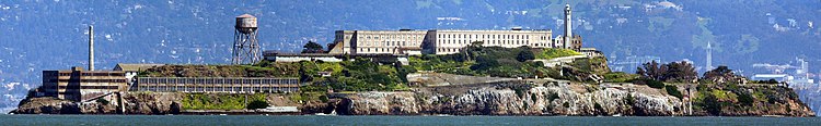
| 3 | Alcatraz Island |  |
January 17, 1986 (#76000209) |
San Francisco 37°49′35″N 122°25′21″W / 37.8264°N 122.4225°W | San Francisco | Former maximum security Federal prison; Frank Morris escaped, but few others did; part of Golden Gate National Recreation Area; visited by tourist ferries. |
| 4 | Alma (scow schooner) |  |
June 7, 1988 (#75000179) |
San Francisco 37°48′28″N 122°25′15″W / 37.8077°N 122.4208°W | San Francisco | Flat-bottomed scow schooner that was built in 1891 and used in San Francisco Bay and Sacramento-San Joaquin River Delta. Now part of the San Francisco Maritime National Historical Park. Official plaque located in the San Francisco Maritime National Historical Park Visitor Center, located at the corner of Hyde and Jefferson streets. |
| 5 | Angelus Temple |  |
April 27, 1992 (#92001875) |
Los Angeles 34°04′35″N 118°15′41″W / 34.0763°N 118.2613°W | Los Angeles | Church built by and for Aimee Semple McPherson, evangelical sensation of the 1920s and 1930s. |
| 6 | Juan de Anza House |  |
April 15, 1970 (#70000140) |
San Juan Bautista 36°50′37″N 121°32′07″W / 36.8436°N 121.5353°W | San Benito | One-story adobe house typical of Mexican era, later "Americanized", also in typical way. |
| 7 | Aquatic Park Historic District |  |
May 28, 1987 (#84001183) |
San Francisco 37°48′23″N 122°25′25″W / 37.8064°N 122.4236°W | San Francisco | Streamline Moderne beach, pier, and public bathhouse built by the WPA in 1936. Official plaque located in the San Francisco Maritime National Historical Park Visitor Center, located at the corner of Hyde and Jefferson Streets. |
| 8 | Asilomar Conference Grounds |  |
February 27, 1987 (#87000823) |
Pacific Grove 36°37′11″N 121°55′53″W / 36.6197°N 121.9314°W | Monterey | Arts and Crafts style conference center built for the YWCA by Julia Morgan in 1913. |
| 9 | Balboa Park |  |
December 22, 1977 (#77000331) |
San Diego 32°43′53″N 117°08′43″W / 32.7314°N 117.1453°W | San Diego | 1,200 acre (4.9 km2) urban cultural complex in San Diego. Reserved in 1855, it is one of the oldest public recreation sites in the US. It includes open areas and vegetation as well as museums, theaters, gardens, shops, restaurants and the San Diego Zoo. |
| 10 | Balclutha (square-rigger) |  |
February 4, 1985 (#76000178) |
San Francisco 37°48′36″N 122°25′21″W / 37.8099°N 122.4225°W | San Francisco | The only remaining square rigged ship in the San Francisco Bay area, it was built in 1886 and served on several different trade routes. It is now part of the San Francisco Maritime National Historical Park. Official plaque located in the San Francisco Maritime National Historical Park Visitor Center, located at the corner of Hyde and Jefferson streets. |
| 11 | Baldwin Hills Village |  |
January 3, 2001 (#93000269) |
Baldwin Hills 34°01′11″N 118°21′39″W / 34.0197°N 118.3608°W | Los Angeles | Now known as Village Green, this 627 unit condo complex was one of the first new planned communities when it was built between 1935 and 1942. |
| 12 | Hubert H. Bancroft Ranch House |  |
December 29, 1962 (#66000227) |
Spring Valley 32°44′44″N 117°00′07″W / 32.745569°N 117.001974°W | San Diego | Adobe home of historian and ethnologist Hubert Howe Bancroft, publisher of many Pacific Coast histories and books on Native American culture. |
| 13 | Bank of Italy Building |  |
June 2, 1978 (#78000754) |
San Francisco 37°47′40″N 122°24′11″W / 37.7944°N 122.4030°W | San Francisco | Became the headquarters of Bank of Italy in 1908 (precursor of the Bank of America); also known as the Clay-Montgomery Building. |
| 14 | Aline Barnsdall Complex (Hollyhock House) |  |
March 29, 2007 (#71000143) |
Los Angeles 34°06′00″N 118°17′41″W / 34.0999°N 118.2946°W | Los Angeles | Hollyhock House, a building designed by Frank Lloyd Wright and built in 1919–1921 for Aline Barnsdall. Now the centerpiece of the Barnsdall Art Park. |
| 15 | Berkeley (ferry) | 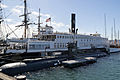 |
December 14, 1990 (#90002220) |
San Diego 32°43′01″N 117°10′21″W / 32.7169°N 117.1726°W | San Diego | First propeller-driven ferry on the west coast; currently the main "building" of the Maritime Museum of San Diego. |
| 16 | Big Four House |  |
July 4, 1961 (#76000541) |
Sacramento 38°34′58″N 121°30′12″W / 38.5827°N 121.503333°W | Sacramento | Built in 1852; house where Collis Huntington, Mark Hopkins, Leland Stanford, and Charles Crocker organized the Central Pacific railway and founded the Southern Pacific Railroad. |
| 17 | Bodie Historic District |  |
July 4, 1961 (#66000213) |
Bodie 38°12′44″N 119°00′44″W / 38.21222°N 119.01222°W | Mono | Established in 1859, it became a Gold Rush boomtown in 1876. It is currently a State park preserved in arrested decay, neither restored nor destroyed. It is one of very few towns of this type to survive untouched. |
| 18 | Borax Lake Site |  |
September 20, 2006 (#91001424) |
Clearlake | Lake | The archaeological type site of the unique Paleo-Indian Clovis people known as the Post Pattern. This site extended their known range and introduced an unusual lake shore dwelling population. |
| 19 | Bradbury Building | 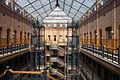 |
May 5, 1977 (#71000144) |
Los Angeles 34°03′03″N 118°14′53″W / 34.050744°N 118.248170°W | Los Angeles | 1893 Italian Renaissance architectural landmark. Known for its striking interiors and cage elevators. It has been used extensively as a location in films such as Blade Runner. |
| 20 | Luther Burbank House and Garden |  |
June 19, 1964 (#66000241) |
Santa Rosa 38°26′10″N 122°42′44″W / 38.436141°N 122.712208°W | Sonoma | City park containing the former home, greenhouse, gardens, and grave of noted American horticulturist Luther Burbank. |
| 21 | C.A. Thayer (schooner) |  |
November 13, 1966 (#66000229) |
San Francisco 37°48′28″N 122°25′16″W / 37.8079063201°N 122.421081619°W | San Francisco | Schooner built in 1895; now preserved at the San Francisco Maritime National Historical Park; worked in lumber trade to San Francisco from Washington, Oregon, and Northern California. Official plaque located in the San Francisco Maritime National Historical Park Visitor Center, located at the corner of Hyde and Jefferson Streets. |
| 22 | California Powder Works Bridge | 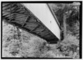 |
February 27, 2015 (#15000279) |
Santa Cruz 37°00′38″N 122°02′38″W / 37.0106°N 122.044°W | Santa Cruz | A 1872 covered bridge that is one of the best-preserved national examples of the Smith truss design. |
| 23 | Carmel Mission |  |
October 9, 1960 (#66000214) |
Carmel 36°32′28″N 121°55′07″W / 36.5410005723°N 121.918551601°W | Monterey | The second Roman Catholic California Mission Church, this was the headquarters of the padre presidente, Father Fermin Francisco de Lasuen. It was destroyed in the mid-19th century and restored in 1884 and 1920. It remains a parish church today. |
| 24 | Carrizo Plain Archeological District |  |
March 2, 2012 (#01000509) |
San Luis Obispo 35°11′29″N 119°43′34″W / 35.191389°N 119.7261°W | San Luis Obispo | Historically important and environmentally sensitive grassland area. It is the largest single native grassland remaining in California. |
| 25 | Jose Castro House |  |
May 15, 1970 (#70000141) |
San Juan Bautista 36°50′34″N 121°32′05″W / 36.8428379948°N 121.534683313°W | San Benito | Historic adobe home built by José Castro, Commandant General of Northern California. It is part of the San Juan Bautista Historic District. |
| 26 | Chicano Park |  |
December 23, 2016 (#100000802) |
San Diego 32°42′01″N 117°08′37″W / 32.7003297°N 117.1436433°W | San Diego | A community-run park known for its vivid murals celebrating Mexican and Chicano culture, founded after a twelve-day occupation by Mexican-American residents to prevent the city from building a parking lot and police substation. |
| 27 | Coloma | 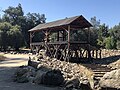 |
July 4, 1961 (#66000207) |
Coloma 38°48′00″N 120°53′21″W / 38.8°N 120.8892°W | El Dorado | Town where the California Gold Rush began when James W. Marshall discovered gold at Sutter's mill on January 24, 1848. Now a ghost town, it is a significant part of the Marshall Gold Discovery State Historic Park |
| 28 | Columbia Historic District |  |
July 4, 1961 (#66000242) |
Sonora 38°02′09″N 120°24′04″W / 38.0357889°N 120.401058°W | Tuolumne | Within two years of discovering gold in this town, it was the 3rd largest city in California. The historic district is now an open museum and the best preserved California Gold Rush town. |
| 29 | Commander's House, Fort Ross |  |
May 15, 1970 (#70000150) |
Fort Ross 38°30′52″N 123°14′37″W / 38.5144°N 123.24361°W | Sonoma | Only original structure at Fort Ross, built 1812 by Russians; also known as Rotchev House. |
| 30 | Coso Rock Art District (formerly Big and Little Petroglyph Canyons) |  |
July 8, 2001 (#99001178) |
Naval Air Weapons Station China Lake | Inyo | Over 20,000 Indian petroglyphs are located in this NHLD, which also incorporates two earlier NHLs: Big and Little Petroglyph Canyons. The site is located within Naval Air Weapons Station China Lake. |
| 31 | Donner Camp Sites |  |
January 20, 1961 (#66000218) |
Truckee 39°19′12″N 120°14′30″W / 39.32°N 120.241667°W | Nevada | Museum and monument to Donner party; trapped by weather during the winter of 1846–1847; resorted to cannibalism to survive |
| 32 | Drakes Bay Historic and Archeological District |  |
October 16, 2012 (#12001006) |
Drakes Bay 38°02′03″N 122°56′27″W / 38.034223°N 122.940800°W | Marin | The recognized landing site of Francis Drake in 1579 and Sebastian Rodriguez Cermeño in 1595, and the early interactions between Native Americans and these European visitors. |
| 33 | Eames House (Case Study House #8) |  |
September 20, 2006 (#06000978) |
Pacific Palisades 34°01′47″N 118°31′10″W / 34.029722°N 118.519444°W | Los Angeles | Built in 1949 by husband-and-wife design pioneers Charles and Ray Eames; also known as Case Study House No. 8. |
| 34 | Elmshaven (Ellen White House) |  |
November 4, 1993 (#93001609) |
St. Helena 38°32′06″N 122°28′41″W / 38.5351240606°N 122.477946296°W | Napa | Ellen Gould White lived and worked here from 1900 until her death in 1915. She was notable for her prophetic ministry which led to the rise of the Seventh-day Adventist Church. |
| 35 | Estudillo House |  |
April 15, 1970 (#70000143) |
San Diego 32°45′15″N 117°11′49″W / 32.754196°N 117.197075°W | San Diego | Adobe house; constructed in 1827; was considered one of the finest houses in Mexican California. |
| 36 | Eureka (double-ended ferry) |  |
February 4, 1985 (#73000229) |
San Francisco 37°48′27″N 122°25′17″W / 37.8074567997°N 122.42131233°W | San Francisco | Side-wheel paddle steamboat; built in 1890 by the San Francisco and North Pacific Railroad Company; preserved at the San Francisco Maritime National Historical Park. Official plaque located in the San Francisco Maritime National Historical Park Visitor Center, located at the corner of Hyde and Jefferson Streets. |
| 37 | USCGC Fir |  |
April 27, 1992 (#92001880) |
Stockton 38°09′00″N 121°40′59″W / 38.149918°N 121.683176°W | San Joaquin | 174 foot U.S. Coast Guard cutter; lighthouse tender; decommissioned. |
| 38 | First Church of Christ, Scientist |  |
December 22, 1977 (#77000283) |
Berkeley 37°51′56″N 122°15′20″W / 37.865504°N 122.255642°W | Alameda | Church designed by Bernard Ralph Maybeck |
| 39 | James C. Flood Mansion |  |
November 13, 1966 (#66000230) |
San Francisco 37°47′31″N 122°24′39″W / 37.791854°N 122.410818°W | San Francisco | Mansion of James C. Flood, 19th century silver-baron; first brownstone building built west of the Mississippi River; one of the only buildings on Nob Hill to survive the 1906 San Francisco earthquake and fire; purchased by the Pacific-Union Club after the earthquake |
| 40 | Folsom Powerhouse |  |
May 29, 1981 (#73000426) |
Folsom 38°40′50″N 121°10′32″W / 38.680556°N 121.175556°W | Sacramento | Built in late 19th century using prison labor from Folsom Prison; first delivered power to Sacramento in 1895; remained in operation until 1952. |
| 41 | Fort Ross | 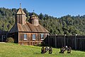 |
November 5, 1961 (#66000239) |
Fort Ross 38°30′45″N 123°14′34″W / 38.5124247055°N 123.242708003°W | Sonoma | Established by Ivan Kuskov of the Russian-American Company in 1812; thriving settlement from 1812 to 1841 |
| 42 | Fresno Sanitary Landfill |  |
August 7, 2001 (#01001050) |
Fresno 36°42′00″N 119°49′47″W / 36.7°N 119.829722°W | Fresno | Opened in 1937; first modern landfill in the U.S.; model for other landfills around the country; and one of the longest-lived. |
| 43 | David B. Gamble House |  |
December 22, 1977 (#71000155) |
Pasadena 34°09′06″N 118°09′37″W / 34.151669°N 118.160364°W | Los Angeles | Arts and Crafts masterpiece; shows influence from traditional Japanese aesthetics and a certain California spaciousness born of available land and a permissive climate. |
| 44 | González House |  |
April 15, 1970 (#70000149) |
Santa Barbara 34°25′27″N 119°41′45″W / 34.424217°N 119.695856°W | Santa Barbara | Built about 1825 by Don Rafael Gonzales; typical of Mexican-era adobe town houses; adobe walls at least 2' thick |
| 45 | Guajome Ranch House |  |
April 15, 1970 (#70000145) |
Vista 33°14′00″N 117°15′14″W / 33.233375°N 117.253969°W | San Diego | Spanish Colonial hacienda with two courtyards. |
| 46 | Gunther Island Site 67 |  |
July 19, 1964 (#66000208) |
Eureka 40°48′36″N 124°10′19″W / 40.809999°N 124.1719444°W | Humboldt | An archaeological site surrounding a Wiyot shell midden, located in Tolowot, on Indian Island in Humboldt Bay near Eureka, California. This site helped define the Gunther Pattern in archaeology and was also the site of the 1860 Wiyot Massacre. |
| 47 | Hale Solar Observatory | 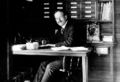 |
December 20, 1989 (#86000103) |
Pasadena 34°07′59″N 118°07′19″W / 34.132974°N 118.121818°W | Los Angeles | Laboratory of George Ellery Hale, inventor of the spectroheliograph, with which he made his discoveries of the solar vortices and magnetic fields of sun spots. |
| 48 | Hanna-Honeycomb House |  |
June 29, 1989 (#78000780) |
Palo Alto 37°24′58″N 122°09′51″W / 37.416131°N 122.164135°W | Santa Clara | Located on Stanford University campus, this was Frank Lloyd Wright's first work in the San Francisco region as well as his first work with non-rectangular structures. |
| 49 | Harada House |  |
December 14, 1990 (#77000325) |
Riverside 33°59′07″N 117°22′09″W / 33.985167°N 117.369250°W | Riverside | Property involved in 1916–1918 constitutional test of an alien land law; at issue was the rights of the children of a Japanese immigrant |
| 50 | Hearst San Simeon Estate |  |
May 11, 1976 (#72000253) |
San Simeon 35°41′06″N 121°10′04″W / 35.684999999999995°N 121.16777777777779°W | San Luis Obispo | Built by newspaper magnate William Randolph Hearst; open for public tours; Hearst formally named the estate "La Cuesta Encantada". |
| 51 | Hercules (tug) |  |
January 17, 1986 (#75000225) |
San Francisco 37°48′30″N 122°25′16″W / 37.8084470841°N 122.421077397°W | San Francisco | This 1907 steam tug is now a museum ship at the San Francisco Maritime National Historical Park. Official plaque located in the San Francisco Maritime National Historical Park Visitor Center, located at the corner of Hyde and Jefferson Streets. |
| 52 | Lou Henry and Herbert Hoover House |  |
February 4, 1985 (#78000786) |
Palo Alto 37°25′04″N 122°10′09″W / 37.417719°N 122.169060°W | Santa Clara | Designed by Lou Henry Hoover, wife of Herbert Hoover, this is where the Hoovers lived before and after his presidency. It is now the official residence of the president of Stanford University |
| 53 | USS Hornet (CVS-12) (aircraft carrier) |  |
December 4, 1991 (#91002065) |
Alameda 37°46′22″N 122°18′10″W / 37.77272°N 122.302895°W | Alameda | Essex class aircraft carrier which was commissioned in November 1943. She played a role in the Pacific battles of World War II and then went on to serve in the Vietnam War. It also recovered the Apollo Astronauts as they returned from the Moon. |
| 54 | Hotel del Coronado |  |
May 5, 1977 (#71000181) |
Coronado 32°40′51″N 117°10′36″W / 32.680895°N 117.176599°W | San Diego | The largest beach resort on the North American Pacific Coast, this Victorian building is an iconic symbol of San Diego. |
| 55 | Edwin Hubble House |  |
December 8, 1976 (#76000494) |
San Marino 34°07′24″N 118°07′17″W / 34.123261°N 118.121400°W | Los Angeles | Home of astronomer Edwin Hubble from 1925 until his death in 1953. |
| 56 | Jeremiah O'Brien (Liberty ship) |  |
January 14, 1986 (#78003405) |
San Francisco 37°48′23″N 122°25′43″W / 37.8063206324°N 122.428591541°W | San Francisco | This Liberty ship is a rare survivor of the 6,939-ship armada that stormed Normandy on D-Day, 1944. |
| 57 | Knight's Ferry Bridge |  |
October 16, 2012 (#12001014) |
Knights Ferry 37°49′10″N 120°39′49″W / 37.819497°N 120.663618°W | Stanislaus | A 1863 covered bridge that is one of the best-preserved examples of the Howe truss design. |
| 58 | La Purisima Mission |  |
April 15, 1970 (#70000147) |
Lompoc 34°40′18″N 120°25′21″W / 34.671803°N 120.422457°W | Santa Barbara | Now a historical park, it is the only example in California of a "complete" mission complex. |
| 59 | Lake Merritt Wild Duck Refuge |  |
May 23, 1963 (#66000205) |
Oakland 37°48′14″N 122°15′33″W / 37.8039°N 122.2591°W | Alameda | Now known as Lake Merritt Park, it is notable for being the first official wildlife refuge in the United States, designated in 1870. |
| 60 | Lane Victory (victory ship) |  |
December 14, 1990 (#90002222) |
San Pedro 33°42′52″N 118°16′29″W / 33.714444°N 118.274722°W | Los Angeles | A rare example of a Victory Ship, it is now a still operational museum ship which makes 6 public cruises a year to Catalina Island. |
| 61 | Larkin House | 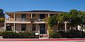 |
December 19, 1960 (#66000215) |
Monterey 36°35′56″N 121°53′44″W / 36.598893°N 121.895642°W | Monterey | This house, part of the larger landmark district Monterey State Historic Park, combined Spanish building techniques with New England features, creating the Monterey Colonial style of architecture. |
| 62 | Las Flores Adobe |  |
November 24, 1968 (#68000021) |
Camp Pendleton 33°18′00″N 117°27′40″W / 33.299949°N 117.461067°W | San Diego | An estancia halfway between two missions, it is now part of a Boy Scout camp located inside Camp Pendleton just off of Interstate 5. |
| 63 | Leconte Memorial Lodge |  |
May 28, 1987 (#77000148) |
Yosemite National Park 37°44′18″N 119°34′42″W / 37.7383029633°N 119.578421199°W | Mariposa | Built by the Sierra Club in 1903 in honor of Joseph LeConte, one of the founding members of the Sierra Club. It was a Yosemite visitors center, but is now run by the Sierra Club as a museum and library. |
| 64 | Lightship WAL-605, Relief | 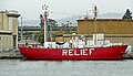 |
December 20, 1989 (#89002462) |
Oakland 37°47′44″N 122°16′50″W / 37.795689°N 122.280592°W | Alameda | A lightvessel now located in Oakland |
| 65 | Little Tokyo Historic District |  |
June 12, 1995 (#86001479) |
Los Angeles 34°03′02″N 118°14′22″W / 34.050556°N 118.239444°W | Los Angeles | An ethnic Japanese American district in downtown Los Angeles, one of three official Japantowns in the United States. |
| 66 | Locke Historic District |  |
December 14, 1990 (#71000174) |
Locke 38°15′02″N 121°30′35″W / 38.25055555555556°N 121.50972222222222°W | Sacramento | The largest remaining example of a historic rural Chinese American community, built in 1915. |
| 67 | Jack London Ranch |  |
December 29, 1962 (#66000240) |
Glen Ellen 38°21′02″N 122°32′35″W / 38.350556°N 122.543056°W | Sonoma | Home of Jack London from 1905 until his death. |
| 68 | Los Alamos Ranch House |  |
April 15, 1970 (#70000148) |
Los Alamos 34°45′10″N 120°19′20″W / 34.752909°N 120.322319°W | Santa Barbara | A good example of the Mexican style single story adobe ranch-house located next to the El Camino Real. It was often used as an overnight stop when travelling between Santa Barbara and Monterey. |
| 69 | Los Angeles Memorial Coliseum |  |
July 27, 1984 (#84003866) |
Los Angeles 34°00′50″N 118°17′16″W / 34.014°N 118.28778°W | Los Angeles | The only stadium in the world which has hosted the Summer Olympic Games (1932 /1984), the World Series (1959) and the Super Bowl (1967 /1973). It is currently the home of the USC Trojans football team. |
| 70 | Los Cerritos Ranch House |  |
April 15, 1970 (#70000135) |
Long Beach 33°50′11″N 118°11′40″W / 33.836392°N 118.194523°W | Los Angeles | Largest adobe home built in Southern California during Mexican era. |
| 71 | Lower Klamath National Wildlife Refuge |  |
January 12, 1965 (#66000238) |
Dorris, CA and Klamath Falls, OR 41°58′00″N 121°46′00″W / 41.966667°N 121.76667°W | Siskiyou, CA and Klamath, OR | This national wildlife refuge, established in 1908, was the first large block of public land set aside for wildlife management purposes. Because of the refuge's extensive overlap with the Klamath Basin water reclamation project, it has become an ongoing example of the tensions between conservation and economic demands in public land management. |
| 72 | Manzanar War Relocation Center |  |
February 4, 1985 (#76000484) |
Independence 36°43′41″N 118°09′16″W / 36.7280556°N 118.1544445°W | Inyo | The most widely known American forced relocation camp where 11,070 Japanese Americans were imprisoned during World War II. |
| 73 | Mare Island Naval Shipyard | 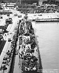 |
May 15, 1975 (#75002103) |
Vallejo 38°06′N 122°16′W / 38.1°N 122.27°W | Solano | The first US naval facility on the West Coast, it built and supported WWII naval forces as well as nuclear submarines. It closed in 1996 and is currently under redevelopment which is threatening the historic buildings. |
| 74 | Marin County Civic Center |  |
July 17, 1991 (#91002055) |
San Rafael 37°59′52″N 122°31′50″W / 37.99778°N 122.530555°W | Marin | The last major commission by Frank Lloyd Wright, this government run complex hosts a variety of events including the county fair. Its architecture has led to inclusion in or inspiration for several films. It is also known for two violent attacks in the 1970s. |
| 75 | Mendocino Woodlands Recreational Demonstration Area |  |
September 25, 1997 (#97001262) |
Mendocino 39°19′43″N 123°41′54″W / 39.3286111°N 123.698333°W | Mendocino | The only Recreational Demonstration Area built by the Civilian Conservation Corps that's been continually used as a campground. It has been managed by a nonprofit agency since 1949 and remains in use today as Mendocino Woodlands State Park. |
| 76 | Mission Beach Roller Coaster |  |
February 27, 1987 (#78000753) |
San Diego 32°46′12″N 117°15′00″W / 32.7699345629°N 117.250059665°W | San Diego | One of only two remaining seaside wooden coasters on the West coast, it was built in 1925 by noted coaster builders Prior and Church. It was saved from destruction in 1987, restored, and is still operating today. |
| 77 | Mission Inn | 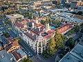 |
May 5, 1977 (#71000173) |
Riverside 33°58′54″N 117°22′18″W / 33.9816175011°N 117.371665653°W | Riverside | This hotel has become the largest Mission Revival style through progressive additions and embellishments since its first predecessor cottage was built in 1876. In addition to lodgings, it features shops, a chapel, furniture from around the world, and Tiffany windows. |
| 78 | Mission San Miguel Arcángel |  |
March 20, 2006 (#71000191) |
San Miguel 35°44′41″N 120°41′53″W / 35.744722°N 120.698056°W | San Luis Obispo | The 16th California Mission church remains well preserved and still in use today though under earthquake remediation construction. Inside are murals by Esteban Munrás. |
| 79 | Mission Santa Inés |  |
January 20, 1999 (#99000630) |
Solvang 34°35′40″N 120°08′12″W / 34.594454°N 120.136657°W | Santa Barbara | The 19th California Mission church was the site of an Indian revolt in 1824. It has undergone restoration since the 1940s and is a working parish church today. |
| 80 | Modjeska House |  |
December 14, 1990 (#72000244) |
Modjeska 33°42′59″N 117°37′26″W / 33.7163426263°N 117.623823831°W | Orange | Designed by Stanford White, from 1888 to 1906 this was the home of Helena Modjeska, a Polish patriot and Shakespearean actress. |
| 81 | Monterey Old Town Historic District | 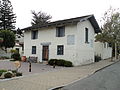 |
April 15, 1970 (#70000137) |
Monterey 36°35′59″N 121°53′37″W / 36.599722°N 121.893611°W | Monterey | Also known as Monterey State Historic Park, this NHLD contains both California's First Theatre, and the Monterey Customs House, where the American flag was first raised over California. It also incorporates the National Historic Landmarked Larkin House known for its leading architecture. |
| 82 | John Muir House |  |
December 29, 1962 (#66000083) |
Martinez 37°59′30″N 122°07′50″W / 37.991679°N 122.130511°W | Contra Costa | John Muir lived here from 1890 until his death in 1914, the time period of some of his most notable achievements including founding the Sierra Club and laying the groundwork for the creation of the National Park Service. It is open to the public. |
| 83 | Neutra Studio and Residences (VDL Research House) |  |
December 23, 2016 (#100000831) |
Los Angeles 34°05′54″N 118°15′38″W / 34.098453°N 118.260456°W | Los Angeles | Served as the home of architect Richard Neutra, which he and his son Dion designed using his innovations in modern architecture. |
| 84 | New Almaden |  |
July 4, 1961 (#66000236) |
San Jose 37°10′48″N 121°50′08″W / 37.18°N 121.835556°W | Santa Clara | Also known as Senador, one of the oldest and most productive mercury mines in the United States. It helped ensure the California Gold Rush could take place. Now part of Almaden Quicksilver County Park. |
| 85 | Richard M. Nixon Birthplace |  |
May 31, 1973 (#71000171) |
Yorba Linda 33°53′19″N 117°49′08″W / 33.888611°N 117.818759°W | Orange | The birthplace and home of President Richard Milhous Nixon from 1913 to 1922. Now part of the Richard Nixon Presidential Library and Museum |
| 86 | Frank Norris Cabin |  |
December 29, 1962 (#66000235) |
Gilroy 37°02′11″N 121°42′45″W / 37.036389°N 121.7125°W | Santa Clara | Also known as Redwood Retreat, this was the home of author Frank Norris in the last year of his life. |
| 87 | Nuestra Señora Reina de la Paz |  |
October 8, 2012 (#11000576) |
Keene 35°13′24″N 118°33′49″W / 35.223413°N 118.563616°W | Kern | Headquarters of the National Farm Workers Federation, now the Cesar Chavez National Monument. Includes the gravesite of co-founder César Chávez |
| 88 | Oak Grove Butterfield Stage Station |  |
November 5, 1961 (#66000222) |
Warner Springs 33°23′23″N 116°47′39″W / 33.389728°N 116.794097°W | San Diego | The only surviving station house on the Butterfield Overland Mail stagecoach line. The nearby location of Warner's Ranch was also part of the line. |
| 89 | Old Customhouse |  |
December 19, 1960 (#66000217) |
Monterey 36°35′46″N 121°53′31″W / 36.5961971882°N 121.892068798°W | Monterey | This 1827 Adobe structure is the oldest public building in California and is where the American Flag was raised, declaring California part of the United States. It is now a museum located inside the Monterey State Historic Park, itself a NHLD. |
| 90 | Old Mission Dam |  |
May 21, 1963 (#66000225) |
San Diego 32°50′17″N 117°02′32″W / 32.8381927311°N 117.042314031°W | San Diego | The first major irrigation project on the Pacific coast, this dam supplied water for milling and irrigation at the Mission San Diego de Alcalá, 5 miles away. Now part of Mission Trails Regional Park |
| 91 | Old Sacramento Historic District |  |
January 12, 1965 (#66000219) |
Sacramento 38°34′58″N 121°30′12″W / 38.582778°N 121.503333°W | Sacramento | Built up after the California Gold Rush, this historic district also includes the NHL locations of the Pony Express Terminal and the Big Four House. |
| 92 | Old Scripps Building |  |
May 20, 1982 (#77000330) |
La Jolla 32°51′52″N 117°15′09″W / 32.864446°N 117.252395°W | San Diego | The first building of Scripps Institution of Oceanography, which is the oldest oceanographic institute in the United States. It formed the starting point of what has become the University of California, San Diego. |
| 93 | Old United States Mint |  |
July 4, 1961 (#66000231) |
San Francisco 37°46′58″N 122°24′23″W / 37.782727°N 122.406479°W | San Francisco | Built for the San Francisco Mint in 1874 to handle the overflow from the California Gold Rush, this building is affectionately known as The Granite Lady. It is one of the few survivors of the great 1906 San Francisco earthquake and served until 1937. |
| 94 | Our Lady of Guadalupe Mission Chapel |  |
December 23, 2016 (#100000836) |
San Jose 37°21′09″N 121°50′41″W / 37.352579°N 121.844681°W | Santa Clara | Now McDonnell Hall, the parish hall of Our Lady of Guadalupe Church; important in the life of activist Cesar Chavez. |
| 95 | USS Pampanito (submarine) |  |
January 14, 1986 (#86000089) |
San Francisco 37°48′31″N 122°24′56″W / 37.8086004153°N 122.415623276°W | San Francisco | A Balao-class submarine, she served in World War II before becoming a museum ship and part of the San Francisco Maritime National Park Association. She still has several working parts, including the periscopes and a torpedo tube. |
| 96 | Paramount Theatre | 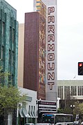 |
May 5, 1977 (#73000395) |
Oakland 37°48′34″N 122°16′05″W / 37.809457°N 122.267984°W | Alameda | The largest theatre on the West Coast when it was built, it is notable for its Art Deco appearance. It is the home of the Oakland East Bay Symphony and the Oakland Ballet and is managed by a nonprofit organization. |
| 97 | Parsons Memorial Lodge |  |
May 28, 1987 (#79000283) |
Yosemite National Park 37°52′36″N 119°22′00″W / 37.8766108572°N 119.366616789°W | Tuolumne | This solidly built structure was the first stone structure in a National Park. It was built by the Sierra Club and is still standing today with only minor variations. It reflects the Bay Area architecture influences of Bernard Maybeck as well as the practical weather concerns of the High Sierra valley. |
| 98 | Petaluma Adobe |  |
April 15, 1970 (#70000151) |
Petaluma 38°15′20″N 122°35′04″W / 38.25547°N 122.58451°W | Sonoma | The largest example of Monterey Colonial architecture in the United States, this adobe structure was the ranch house of General Mariano Guadalupe Vallejo, commandant of the Sonoma Pueblo. It is now the centerpiece of Petaluma Adobe State Historic Park, which is threatened with closure. |
| 99 | Pioneer Deep Space Station |  |
October 3, 1985 (#85002813) |
Fort Irwin 35°23′15″N 116°51′22″W / 35.3874891024°N 116.856198162°W | San Bernardino | NASA's Deep Space Network for tracking uncrewed spacecraft in deep space was inaugurated when this radio telescope (designated DSS 11) became operational in 1958. |
| 100 | Point Reyes Lifeboat Station |  |
December 20, 1989 (#85002756) |
Point Reyes 37°59′38″N 122°58′26″W / 37.993889°N 122.973889°W | Marin | Last remaining instance of a USLS rail launched lifeboat station, commonly used on the Pacific coast. This site rescued crews from ships that foundered on Point Reyes. It is now protected as part of the Point Reyes National Seashore. |
| 101 | Pond Farm Pottery Historic District |  |
December 11, 2023 (#100009799) |
17000 Armstrong Woods Road 38°33′08″N 123°00′00″W / 38.552171°N 122.999991°W | Sonoma County, California | Designated a National Historic Landmark in 2023. |
| 102 | Pony Express Terminal |  |
July 4, 1961 (#66000220) |
Sacramento 38°34′58″N 121°30′15″W / 38.582898°N 121.504248°W | Sacramento | The Western end of the Pony Express, this bank building has also served as the first home of the Supreme Court of California. It is now part of the Old Sacramento State Historic Park, itself a National Historic Landmark District. |
| 103 | Potomac (Presidential yacht) |  |
December 14, 1990 (#87000068) |
Oakland 37°47′37″N 122°16′44″W / 37.793512671°N 122.278992912°W | Alameda | Formerly the USCGC Electra, this ship was Franklin Delano Roosevelt’s presidential yacht from 1936 until his death in 1945 and only one of three still existing presidential yachts. On August 3, 1941, she played a decoy role while Roosevelt snuck off to sign the Atlantic Charter. She is now a museum ship. |
| 104 | Presidio of San Francisco |  |
June 13, 1962 (#66000232) |
San Francisco 37°48′00″N 122°28′00″W / 37.8°N 122.466667°W | San Francisco | Used as a fortified military base from 1776 to 1995 by Spain, Mexico, and the United States. It is now part of the Golden Gate National Recreation Area and serves a mix of commercial and public uses. It is required to be financially self-supporting by 2013. |
| 105 | Ralph J. Scott (fireboat) |  |
June 30, 1989 (#89001430) |
San Pedro 33°44′29″N 118°16′44″W / 33.741292°N 118.278953°W | Los Angeles | A fireboat for the LAFD from 1925 until its retirement in 2003, it could pump 17,000 US gal/min (1,070 L/s). It is now located near the Los Angeles Maritime Museum. |
| 106 | William C. Ralston Home |  |
November 13, 1966 (#66000234) |
Belmont 37°31′03″N 122°17′10″W / 37.5175°N 122.286111°W | San Mateo | Home of William Chapman Ralston, a San Francisco businessman, founder of the Bank of California, and financier of the Comstock Lode. Now part of Notre Dame de Namur University. |
| 107 | Rancho Camulos |  |
February 16, 2000 (#96001137) |
Piru 34°24′20″N 118°45′24″W / 34.40565°N 118.756667°W | Ventura | The home of Ygnacio del Valle, an alcalde of Los Angeles and member of the California State Assembly. The ranch was known as the Home of Ramona because it is likely that the popular 1884 novel Ramona by Helen Hunt Jackson was set there. The novel helped in raising awareness about the Californio lifestyle. It is now a museum. |
| 108 | Rangers' Club |  |
May 28, 1987 (#87001414) |
Yosemite National Park 37°44′44″N 119°35′12″W / 37.7454635709°N 119.586783467°W | Mariposa | Stephen Tyng Mather, the wealthy first director of the National Park Service personally donated this building to house the newly hired rangers covering Yosemite National Park. Its rustic architecture inspired all National Park construction through WWII. |
| 109 | Rogers Dry Lake | 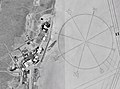 |
October 3, 1985 (#85002816) |
Edwards Air Force Base 34°57′00″N 117°52′00″W / 34.95°N 117.86666666666666°W | Kern and San Bernardino | Centerpiece of Edwards Air Force Base, this endorheic desert salt pan in the Mojave Desert has the world's largest compass rose and the world's longest runway at 7.2 miles. It is one of the alternate Space Shuttle landing sites. |
| 110 | Room 307, Gilman Hall, University of California |  |
December 21, 1965 (#66000203) |
Berkeley 37°52′15″N 122°15′18″W / 37.8708°N 122.2550°W | Alameda | Room 307 in Gilman Hall at UCB is where Glenn T. Seaborg and his coworkers identified plutonium as a new element on February 23, 1941. |
| 111 | Rose Bowl |  |
February 27, 1987 (#87000755) |
Pasadena 34°09′34″N 118°10′00″W / 34.1595343932°N 118.166774324°W | Los Angeles | Home field of the UCLA Bruins college football team as well as the annual Rose Bowl Game. It also hosted events from the 1932 and 1984 Summer Olympics |
| 112 | Royal Presidio Chapel |  |
October 9, 1960 (#66000216) |
Monterey 36°35′45″N 121°53′25″W / 36.595847°N 121.890299°W | Monterey | This cathedral is the oldest continuously operating parish, the oldest stone building in California, the smallest cathedral in the United States and one of the two oldest cathedrals in the United States. It is the only existing Presidio cathedral in California and the only original building in the Monterey Presidio. |
| 113 | San Diego Mission Church |  |
April 15, 1970 (#70000144) |
San Diego 32°46′58″N 117°06′23″W / 32.7827680173°N 117.106253353°W | San Diego | This was the first Spanish Mission in Alta California and the start of El Camino Real. Originally located in the Presidio of San Diego, it later moved a few miles away. The nearby Old Mission Dam, also an NHL, provided water for milling and farming. |
| 114 | San Diego Presidio |  |
October 9, 1960 (#66000226) |
San Diego 32°45′31″N 117°11′36″W / 32.758611°N 117.193333°W | San Diego | The first fortified presidio, it along with the first mission, San Diego Mission Church, paved the way for Spanish colonization of California. No structures remain, but the site is now located in Presidio Park. |
| 115 | San Francisco Bay Discovery Site |  |
May 23, 1968 (#68000022) |
Pacifica 37°36′11″N 122°27′17″W / 37.603056°N 122.454722°W | San Mateo | On November 4, 1769 the expedition of Spanish explorer Gaspar de Portolá reached the summit of the 1,200-foot (370 m) high Sweeney Ridge, where he sighted San Francisco Bay. It is now part of the Golden Gate National Recreation Area. |
| 116 | San Francisco Cable Cars | 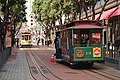 |
January 29, 1964 (#66000233) |
San Francisco 37°47′44″N 122°24′27″W / 37.795556°N 122.4075°W | San Francisco | An iconic image of San Francisco, this is the only remaining permanently operational manually operated cable car system in the world. |
| 117 | San Francisco Civic Center |  |
February 27, 1987 (#78000757) |
San Francisco 37°46′47″N 122°25′04″W / 37.77972222222222°N 122.41777777777779°W | San Francisco | The United Nations Charter was signed here in 1945 as well as the post WWII peace treaty with Japan. This collection of Beaux Arts buildings serves a number of uses, including the Exposition Auditorium from the 1915 Panama-Pacific International Exposition. |
| 118 | San Francisco Port of Embarkation, U.S. Army |  |
February 4, 1985 (#85002433) |
San Francisco 37°48′26″N 122°25′50″W / 37.80722222222222°N 122.43055555555556°W | San Francisco | Originally built during the American Civil War for coastal defense, this fort became the primary transportation hub in the Pacific for the United States during World War I and World War II. In World War II alone, over 1,647,174 passengers and 23,589,472 tons went through this fort. It is now part of the Golden Gate National Recreation Area |
| 119 | San Juan Bautista Plaza Historic District |  |
April 15, 1970 (#69000038) |
San Juan Bautista 36°50′37″N 121°32′04″W / 36.8437377837°N 121.53455399°W | San Benito | A prime example of the Spanish-Mexican colonial plan of buildings surrounding the central plaza and Mission church. The NHLD also includes the Jose Castro House, itself a National Historic Landmark. It was featured prominently in the Alfred Hitchcock film Vertigo. |
| 120 | San Luis Rey Mission Church |  |
April 15, 1970 (#70000142) |
Oceanside 33°22′03″N 117°13′06″W / 33.3675°N 117.218333°W | San Diego | California's most pristine Spanish Mission Complex, this is the third church at this site. |
| 121 | Santa Barbara County Courthouse |  |
April 5, 2005 (#81000177) |
Santa Barbara 34°25′28″N 119°42′09″W / 34.42435°N 119.702461°W | Santa Barbara | Known for the beauty of its Spanish-Colonial Revival architecture, which inspired and influenced many other designers. |
| 122 | Santa Barbara Mission |  |
October 9, 1960 (#66000237) |
Santa Barbara 34°26′15″N 119°42′45″W / 34.437362°N 119.712634°W | Santa Barbara | The only Spanish mission in California to remain under the leadership of the Franciscan Friars since the day of its founding. |
| 123 | Santa Cruz Looff Carousel and Roller Coaster |  |
February 27, 1987 (#87000764) |
Santa Cruz 36°57′52″N 122°01′00″W / 36.964444444444446°N 122.01666666666667°W | Santa Cruz | The Looff family was one of the major early manufacturers of carousels, including this 1911 example. Only five other intact Looff carousels remain in the United States. The 1924 Giant Dipper roller coaster is the older of the two large, wooden scaffolded seaside roller coasters remaining on the West Coast. |
| 124 | Santa Monica Looff Hippodrome |  |
February 27, 1987 (#87000766) |
Santa Monica 34°00′37″N 118°29′47″W / 34.010184°N 118.496368°W | Los Angeles | Built by the Looff family to house one of their carousels, this structure now houses a different carousel, but remains a rare example of what was once a much larger amusement complex. |
| 125 | Upton Sinclair House |  |
November 11, 1971 (#71000153) |
Monrovia 34°09′43″N 118°00′04″W / 34.161969°N 118.001210°W | Los Angeles | Home of American novelist Upton Sinclair between 1942 and 1966 and where he wrote most of his later works. |
| 126 | Sonoma Plaza | 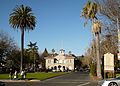 |
December 19, 1960 (#75000489) |
Sonoma 38°17′04″N 122°27′27″W / 38.2844470556°N 122.457393148°W | Sonoma | The largest plaza in California, this was the location of the Bear Flag Revolt in 1846 which led to the Mexican–American War |
| 127 | Space Flight Operations Facility |  |
October 3, 1985 (#85002814) |
Pasadena 34°11′58″N 118°10′25″W / 34.1993285017°N 118.173617161°W | Los Angeles | Control room at Jet Propulsion Laboratory where all NASA interplanetary and deep space missions are monitored. |
| 128 | Space Launch Complex 10 |  |
June 23, 1986 (#86003511) |
Vandenberg Air Force Base 34°45′55″N 120°37′20″W / 34.765278°N 120.622222°W | Santa Barbara | First built in 1958 to test missiles, it was used to launch space missions from 1963 to 1980. It is now a rare, well-preserved example of the equipment and facilities from that era. |
| 129 | Leland Stanford House |  |
May 28, 1987 (#71000178) |
Sacramento 38°34′36″N 121°29′52″W / 38.576528°N 121.497914°W | Sacramento | The home of Leland Stanford, Governor of California from 1862 to 1863, U.S. Senator from 1885 to 1893, railroad tycoon, member of the Big Four and founder of Stanford University. |
| 130 | Star of India (bark) |  |
November 13, 1966 (#66000223) |
San Diego 32°42′51″N 117°10′22″W / 32.7142265105°N 117.172862915°W | San Diego | A seaworthy iron hulled museum ship in the San Diego Maritime Museum, she is the oldest ship that still sails regularly and the oldest iron hulled merchant ship still floating. |
| 131 | Steedman Estate (Casa del Herrero) |  |
January 16, 2009 (#87000002) |
Montecito 34°26′07″N 119°38′08″W / 34.43527777777778°N 119.63555555555556°W | Santa Barbara | Designed by architect George Washington Smith, this 11-acre, 1920s estate is considered one of the finest examples of Spanish Colonial Revival architecture in the United States. |
| 132 | Sutter's Fort |  |
January 20, 1961 (#66000221) |
Sacramento 38°34′14″N 121°28′12″W / 38.5704472774°N 121.470071911°W | Sacramento | A 19th century agricultural and trade colony, it was known for its connection to the Donner Party, the California Gold Rush, and the formation of Sacramento as well as its proximity to the California Trail and Siskiyou Trails. Now a state park, threatened with closure in 2008. |
| 133 | Swedenborgian Church | 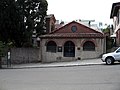 |
August 18, 2004 (#04001154) |
San Francisco 37°47′25″N 122°26′45″W / 37.790229°N 122.445882°W | San Francisco | One of California's earliest pure Arts and Crafts buildings, this Swedenborgianism church remains open today with almost no architectural changes. |
| 134 | Tao House |  |
July 17, 1971 (#71000137) |
Danville 37°49′33″N 122°01′39″W / 37.825961°N 122.02755°W | Contra Costa | America's only Nobel Prize-winning playwright Eugene O'Neill lived here from 1937 to 1944 while writing his final and most memorable plays: The Iceman Cometh, Long Day's Journey Into Night, and A Moon for the Misbegotten. |
| 135 | The Forty Acres |  |
October 6, 2008 (#08001090) |
Delano 35°45′48″N 119°17′15″W / 35.76325278°N 119.287497221°W | Kern | Served as the original headquarters of the United Farm Workers, the first permanent agricultural labor union in the United States. |
| 136 | Tule Lake Segregation Center |  |
February 17, 2006 (#06000210) |
Newell 41°53′08″N 121°22′26″W / 41.88544°N 121.373768°W | Modoc | The largest Japanese American internment camp, it also had the highest security and stayed open longest, even after World War II. The Redress movement in the 1980s and pilgrimages to Tule Lake led to the Civil Liberties Act of 1988. |
| 137 | Twenty-Five-Foot Space Simulator | 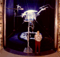 |
October 3, 1985 (#85002812) |
Pasadena 34°12′03″N 118°10′22″W / 34.2009587786°N 118.172880016°W | Los Angeles | An 85 foot high stainless-steel cylinder at the Jet Propulsion Laboratory used for testing spacecraft in space-like conditions. Ranger, Surveyor, Mariner, and Voyager spacecraft were all tested in this facility. |
| 138 | Unitary Plan Wind Tunnel |  |
October 3, 1985 (#85002799) |
Moffett Field 37°24′56″N 122°03′35″W / 37.4156663073°N 122.059785401°W | Santa Clara | This wind tunnel built in the 1950s allowed commercial and military aircraft as well as the Space Shuttle to be aerodynamically tested. |
| 139 | United States Immigration Station, Angel Island | 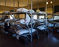 |
December 9, 1997 (#71000164) |
Tiburon 37°51′44″N 122°25′13″W / 37.862222°N 122.4202778°W | Marin | The "Ellis Island of the West" processed over 1 million Asian immigrants between 1910 and 1940. Now part of Angel Island State Park, it was renovated in 2009. |
| 140 | United States Post Office and Court House (Court House for the Central District of California) | 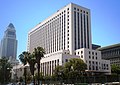 |
October 16, 2012 (#06000001) |
Los Angeles 34°03′18″N 118°14′33″W / 34.055053°N 118.242481°W | Los Angeles | Courthouse built in 1940, reflecting Art Moderne architecture. |
| 141 | United States Post Office and Court House (James R. Browning U.S. Court of Appeals) |  |
October 16, 2012 (#71000188) |
San Francisco 37°46′46″N 122°24′40″W / 37.779404°N 122.411162°W | San Francisco | Courthouse built in 1905, reflecting the Beaux Arts classicism used in several early twentieth-century federal buildings. |
| 142 | Walker Pass | 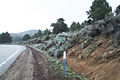 |
July 4, 1961 (#66000210) |
Onyx 35°39′47″N 118°01′37″W / 35.663056°N 118.026944°W | Kern | Joseph Reddeford Walker mapped this pass in 1834 after learning of it from Native Americans. He then led the first immigrant wagon train through it in 1846. This pass significantly contributed to the development of California. |
| 143 | Warner's Ranch | 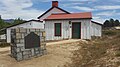 |
January 20, 1961 (#66000228) |
Warner Springs 33°14′19″N 116°39′03″W / 33.238611°N 116.650833°W | San Diego | The only trading post between New Mexico and Los Angeles, this ranch developed into a stop on the Butterfield Overland Mail stagecoach line along with nearby Oak Grove. Now a hot springs resort. |
| 144 | Watts Towers |  |
December 14, 1990 (#77000297) |
Los Angeles 33°56′13″N 118°14′26″W / 33.9369667128°N 118.240549404°W | Los Angeles | These towers built by Simon Rodia are a superb example of non-traditional vernacular architecture and American Naïve art. |
| 145 | Wawona Hotel and Thomas Hill Studio |  |
May 28, 1987 (#75000223) |
Yosemite National Park 37°32′11″N 119°39′13″W / 37.536389°N 119.653611°W | Mariposa | Built in 1879 for tourists visiting the Mariposa Grove, this hotel is also where the Hudson River School painter Thomas Hill painted towards the end of his life. |
| 146 | Wayfarers Chapel | 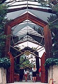 |
December 11, 2023 (#100009801) |
5755 Palos Verdes Dr. S 33°44′41″N 118°22′33″W / 33.744722°N 118.375833°W | Los Angeles County, California | Designed by Lloyd Wright, this church is well-preserved example of post-World War II Modern ecclesiastical architecture and landscaping. |
| 147 | Well No. 4, Pico Canyon Oil Field |  |
November 13, 1966 (#66000212) |
Stevenson Ranch 34°22′10″N 118°37′49″W / 34.369444°N 118.630278°W | Los Angeles | Drilled in 1876 to 376 feet (115 m), this was the first commercially successful oil well in California, producing 25 barrels a day (4 m3/d). |
| 148 | Yuma Crossing and Associated Sites |  |
November 13, 1966 (#66000197) |
Winterhaven 32°43′45″N 114°36′55″W / 32.7292°N 114.6153°W | Imperial | A major crossroads for Alta California as well as the Westward expansion of the United States. It has several archaeological and historical sites, shared with Arizona across the Colorado River, including Fort Yuma and other state parks. |
Former NHLs edit
In addition, there are four sites that were once National Historic Landmarks in California but are not currently.
| Landmark name[5] | Image |
Date designated[5] | Date moved or withdrawn[5] |
Location[5][6] | Description[6] | |
|---|---|---|---|---|---|---|
| 1 | First Pacific Coast Salmon Cannery Site | April 6, 1964 | July 14, 2004[7] | Broderick, Yolo County 38°34′51″N 121°30′26″W / 38.5808401987°N 121.507276585°W |
The first Pacific Coast salmon cannery was established on this site in 1864. However, nothing of the original operation remains, and numerous floods and the establishment of a city park on the former site altered the riverbank's appearance to such a degree that the NHL designation was withdrawn in 2004.[7] | |
| 2 | Fort Ross Chapel[7] | 
|
1969[7] | 1971[7] | Fort Ross, Sonoma County[7] | The chapel at Fort Ross, a rare example of a log church constructed on a Russian quadrilateral plan, was withdrawn from the NHL listings after a fire destroyed most of the building in 1970. A complete reconstruction of the chapel now stands in its place.[7] |
| 3 | Rock Magnetics Laboratory[7] | 
|
October 12, 1994[7] | March 8, 1999[7] | Menlo Park, San Mateo County[7] | Located at the United States Geological Survey's Menlo Park offices, this is the site where Richard Doell, Allan V. Cox, and Brent Dalrymple researched major discoveries in areas related to geomagnetic reversals and plate tectonics. However, the lab was built in a temporary building, which was demolished in the late 1990s.[7] |
| 4 | Wapama (steam schooner) | 
|
April 20, 1984 | February 27, 2015 | San Francisco | This 204' wooden schooner was the last surviving of 200 ships of its type plying the lumber trade along the Pacific coast. It was scrapped in 2013. |
See also edit
- California Point of Historical Interest
- California Register of Historical Resources
- Historic preservation
- History of California
- List of California Historical Landmarks
- List of California State Historic Parks
- National Register of Historic Places listings in California
- National Register of Historic Places
References edit
- ^ National Park Service. "National Historic Landmarks Program: Questions and Answers". Retrieved September 21, 2007.
- ^ The current NPS list shows 146 NHLs, of which two are no longer active: "City of Oakland" relocated to Arkansas and First Pacific Coast Cannery Site withdrawn.Requested Page Not Found (404) (PDF), retrieved April 21, 2019
{{citation}}: Cite uses generic title (help) - ^ Numbers represent an alphabetical ordering by significant words. Various colorings, defined here, differentiate National Historic Landmarks and historic districts from other NRHP buildings, structures, sites or objects.
- ^ The eight-digit number below each date is the number assigned to each location in the National Register Information System database, which can be viewed by clicking the number.
- ^ a b c d National Park Service (June 2011). "National Historic Landmarks Survey: List of National Historic Landmarks by State" (PDF). Archived from the original (PDF) on November 5, 2011. Retrieved July 4, 2011..
- ^ a b National Park Service. "National Historic Landmark Program: NHL Database". Archived from the original on June 6, 2004. retrieved on various dates, and other sources cited in the articles on each of the sites.
- ^ a b c d e f g h i j k l National Park Service. "National Historic Landmark Program: Withdrawal of National Historic Landmark Designation". Retrieved October 29, 2013.
Further reading edit
External links edit
- National Historic Landmarks Program, at National Park Service
- National Park Service listings of National Historic Landmarks