


Summary
Lhokseumawe (Indonesian pronunciation: [loksuˈmawe]; Acehnese: Lhôk Seumaw‘è, Jawoë: لهوکسيوماوي), is the second largest city (by population, after Bandar Aceh) in Aceh province, Indonesia, having recently overtaken Langsa. The city covers an area of 181.06 square kilometres, and had a population of 171,163 at the 2010 census[4] and 188,713 at the 2020 census;[5] the official estimate as at mid 2023 was 196,067 (comprising 97,339 males and 98,728 females).[1] The city is a key regional centre important for the economy of Aceh.
Lhokseumawe
Lhôk Seumaw‘è | |
|---|---|
| Other transcription(s) | |
| • Jawoë | لهوکسيوماوي |
 Rencong monument of Lhokseumawe | |
 Coat of arms | |
| Motto(s): Lhokseumawe Indah (Beautiful Lhokseumawe) | |
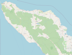
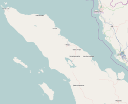
 Location within Aceh | |
| Coordinates: 5°11′17″N 97°8′25″E / 5.18806°N 97.14028°E | |
| Country | Indonesia |
| Region | Sumatra |
| Province | Aceh |
| City Founded | 21 June 2001 |
| Government | |
| • Mayor | Suaidi Yahya |
| • Vice | Yusuf Muhammad |
| • Secretary | Bukhari A. KS |
| Area | |
| • Total | 181.06 km2 (69.91 sq mi) |
| Elevation | 2−24 m (−77 ft) |
| Population (mid 2023 estimate)[1] | |
| • Total | 196,067 |
| • Density | 1,100/km2 (2,800/sq mi) |
| Demographics | |
| • Languages | Indonesian (official) Acehnese |
| City Growth | |
| • HDI | 77.23 [2] |
| • GDP | Rp. 10.598.205.71 (Million Rupiah) [3] |
| Time zone | UTC+7 (IWST) |
| Postcode | 24351 |
| Area code | (+62) 645 |
| Website | lhokseumawekota |
| For Official Government Website see below of this page | |


History edit
The name Lhokseumawe comes from the words lhok and seumawe. Lhok means "deep", "bay", and "ocean trenches", and Lhokseumawe means the swirling water in the sea along the offshore of Banda Sakti and its surroundings. The city was formerly part of North Aceh Regency, from which it was separated to form an independent city on 21 June 2001. The area is linked to the emergence of the kingdom of Samudera Pasai around the 13th century, which later came under the sovereignty of Sultanate of Aceh in 1511.
Pre Colonial Era edit
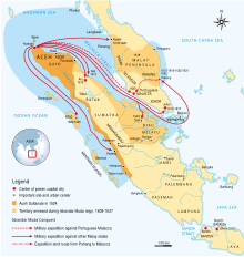
The Sultanate of Aceh was established by Sultan Ali Mughayatsyah in 1511. Later, during its golden era, in the 17th century, its territory and political influence expanded as far as Satun in southern Thailand, Johor in Malay Peninsula, and Siak in what is today the province of Riau. As was the case with most non-Javan pre-colonial states, Acehnese power expanded outward by sea rather than inland. As it expanded down the Sumatran coast, its main competitors were Johor and Portuguese Malacca on the other side of the Straits of Malacca. It was this seaborne trade focus that saw Aceh rely on rice imports from north Java rather than develop self sufficiency in rice production.[6] After the Portuguese occupation of Malacca in 1511, many Islamic traders passing the Malacca Straits shifted their trade to Banda Aceh and increased the Acehnese rulers' wealth. During the reign of Sultan Iskandar Muda in the 17th century, Aceh's influence extended to most of Sumatra and the Malay Peninsula. Aceh allied itself with the Ottoman Empire and the Dutch East India Company in their struggle against the Portuguese and the Johor Sultanate. Acehnese military power waned gradually thereafter, and Aceh ceded its territory of Pariaman in West Sumatra to the Dutch in the 18th century.[7]
Colonial Era edit

Before the 20th century, the country was ruled by uleebalang Kutablang. In 1903, after resistance fighters against Dutch colonists weakened Aceh, Aceh began to master.
Lhokseumawe conquered areas and from then on the status of Lhokseumawe was "Bestuur Van Lhokseumawe" with Zelf Bestuurder is Teuku Abdul Lhokseumawe subordinate Controeleur aspirants and also domiciled in Lhokseumawe and assistant resident district officer or Regent.
In the second decade of the 20th century, among the entire mainland of Aceh, a small island about 11 km2 widely separated by Krueng Cunda River. filled buildings General Government, Military, and Transportation Railway by the Dutch government. Small islands with villages of Keude Aceh, Kampung Jawa, Kuta blang, Mon Geudong, Teumpok Teungoh, Hagu Kampung, Uteuen bayi and Ujong Blang are entirely new 5,500 plural in Lhokseumawe call. Building by building fills this land until the city has realized embryos harbor, market, railway station and the offices of government agencies.
Independence era edit
On 21 September and 22 September 1953, Darul Islam forces attacked Lhokseumawe twice, but the Indonesian army repelled the attack.[8]
Since the Declaration of Independence, the Government of the Republic of Indonesia has not established systemic to this district. At first Lhokseumawe combined with Bestuurder Van Cunda. The mainland population is increasingly crowded, coming from surrounding areas such as Buloh Blang Ara, Matangkuli, Blang Jruen, Lhoksukon, Nisam, Cunda and Pidie.
In 1956 the Emergency Law No. 7 of 1956, the autonomous regions formed regencies within the region of North Sumatra province, where one of them is the North Aceh Regency with its capital at Lhokseumawe.
Then in 1964 the Decree of the Governor of Aceh Special Region Number 34/GA/1964 dated 30 November 1964, it was determined that Kemukiman Banda Sakti in Muara Dua, the District used its own under the name of the District Banda Sakti.
Based on the Act No. 5 of 1974 on the Principles of Regional Administration, Lhokseumawe be likely to improve the status of the City of, on August 14, 1986, with the Regional Regulation No. 32 of 1986 Establishment of the City of Lhokseumawe signed by President of Indonesia Suharto, which was inaugurated by the Minister of Roestam Soeparjo country on 31 August 1987. Given that it is de jure and de facto Lhokseumawe became the City of the area of 181.06 km2 which includes 101 villages and 6 urban villages in five districts, namely the Districts of Banda Sakti, Muara Dua, Dewantara, Muara Batu, and Blang Mangat.
From 1988 onwards, the idea of improving the status of the town began. Law No. 2 of 2001 (dated 21 June 2001), signed by the president of Indonesia Abdurrahman Wahid, established Lhokseumawe as a separate municipality whose territory then included three districts, namely the districts of Banda Sakti, Muara Dua and Blang Mangat (Dewantara and Muara Batu Districts remained in North Aceh Regency). In 2006 the district of Muara Dua was split into two - Muara Dua and Muara Satu - so Lhokseumawe now has four districts.
Geography edit
Lhokseumawe City is located between 4˚ - 5˚ North Latitude and 96˚ - 97˚ East Longitude with an average altitude of 13 metres above sea level. Lhokseumawe was given the status of an independent city (separate from North Aceh Regency, which surrounds it on all the landward sides) based on Law Number 2 of 2001, dated 21 June 2001. Lhokseumawe City is divided into 4 districts, 9 residents, 68 villages, and 259 sub-villages within the boundaries of the area. Lhokseumawe forms a semi-enclave within North Aceh Regency.
| Direction | Location |
|---|---|
| North | Selat Malaka |
| South | Kecamatan Kuta Makmur, Kabupaten Aceh Utara |
| West | Kecamatan Dewantara, Kabupaten Aceh Utara |
| East | Kecamatan Syamtalira Bayu, Kabupaten Aceh Utara |
Climate edit
Lhokseumawe has a tropical rainforest climate (Af) with moderate to heavy rainfall year-round.
| Climate data for Lhokseumawe | |||||||||||||
|---|---|---|---|---|---|---|---|---|---|---|---|---|---|
| Month | Jan | Feb | Mar | Apr | May | Jun | Jul | Aug | Sep | Oct | Nov | Dec | Year |
| Mean daily maximum °C (°F) | 30.5 (86.9) |
31.6 (88.9) |
32.4 (90.3) |
32.6 (90.7) |
31.9 (89.4) |
32.0 (89.6) |
31.5 (88.7) |
31.7 (89.1) |
31.0 (87.8) |
31.0 (87.8) |
30.4 (86.7) |
30.3 (86.5) |
31.4 (88.5) |
| Daily mean °C (°F) | 26.6 (79.9) |
27.2 (81.0) |
27.7 (81.9) |
28.1 (82.6) |
27.7 (81.9) |
27.8 (82.0) |
27.2 (81.0) |
27.4 (81.3) |
27.1 (80.8) |
27.2 (81.0) |
26.8 (80.2) |
26.7 (80.1) |
27.3 (81.1) |
| Mean daily minimum °C (°F) | 22.8 (73.0) |
22.8 (73.0) |
23.0 (73.4) |
23.6 (74.5) |
23.6 (74.5) |
23.6 (74.5) |
23.0 (73.4) |
23.2 (73.8) |
23.2 (73.8) |
23.5 (74.3) |
23.2 (73.8) |
23.1 (73.6) |
23.2 (73.8) |
| Average rainfall mm (inches) | 164 (6.5) |
64 (2.5) |
75 (3.0) |
95 (3.7) |
123 (4.8) |
87 (3.4) |
87 (3.4) |
102 (4.0) |
128 (5.0) |
183 (7.2) |
189 (7.4) |
234 (9.2) |
1,531 (60.1) |
| Source: Climate-Data.org[9] | |||||||||||||
Administrative districts edit
Lhokseumawe City is an urban area surrounded on the landward side by Aceh Utara Regency and is located on the northeast coast of Sumatra. Being between Banda Aceh and Medan, Lhokseumawe City holds a strategic position as a distribution channel for trading traffic in Aceh Special region.
When separated from North Aceh Regency in 2001, the city was divided administratively into three districts (kecamatan); since then, the creation in 2006 of Muara Satu District (formerly part of Muara Dua District) has increased the number to four. These are tabulated below with their areas and their populations at the 2010[4] and 2020 censuses,[5] together with the official estimates as at mid 2023.[1] The table also includes the locations of the district administrative centres, the number of villages (gampong) in each district, and its post code.
| Kode Wilayah |
Name of District (kecamatan) |
Area in km2 |
Pop'n at 2010 census |
Pop'n at 2020 census |
Pop'n mid 2023 estimate |
Admin centre |
No. of villages |
Post code |
|---|---|---|---|---|---|---|---|---|
| 11.73.03 | Blang Mangat | 56.12 | 21,689 | 26,162 | 28,146 | Punteut | 22 | 24375 |
| 11.73.01 | Muara Dua | 57.80 | 44,209 | 50,929 | 53,068 | Cunda | 17 | 24351 |
| 11.73.04 | Muara Satu | 55.90 | 31,723 | 33,820 | 35,003 | Batuphat Barat | 11 | 24353 |
| 11.73.02 | Banda Sakti | 11.24 | 73,542 | 77,802 | 79,850 | Kota Lhokseumawe | 18 | 24351 (a) |
Note: (a) except for the 5 gampong of Tumpok Teumpoh (post code 24311), Simpang Empat (24313), Kota Lhokseumawe (24314), Pusong Baru (24314) and Jawa Baru (24315).
Source : Lhokseumawe Dalam Angka 2013 / Lhokseumawe In Figures 2013;[10] Badan Pusat Statistik, Jakarta, for later figures.
Judging by the number of village officials, Blang Mangat District is the biggest district, consisting of 22 villages (comprising 78 sub villages), with 259 village officials.
Health edit
Health facilities are available in Lhokseumawe :
| Health facilities | Total | Unit |
|---|---|---|
| Puskesmas | 6 | Unit |
| Puskesmas pembantu | 12 | Unit |
| Puskesmas keliling | 5 | Unit |
| Polindes | 32 | Unit |
| Doctors Practice | 85 | Unit |
| Dentist Practice | 9 | Unit |
| Drug store | 77 | Unit |
The number of available health workers is:
| Health workers | Total | Unit |
|---|---|---|
| Doctor | 60 | People |
| Dentist | 5 | People |
| Medical Servant | 399 | People |
| Nurse | 194 | People |
| Midwife | 151 | People |
| Pharmacy personnel | 9 | People |
| Nutritionist | 4 | People |
| Sanitation expert | 7 | People |
- note : Not include private companies, Only Government Facilities and worker
Source : Lhokseumawe Dalam Angka 2013 / Lhokseumawe In Figures 2013[10]
Religion edit
| Religions | Total |
|---|---|
| Islam | 190,553 |
| Buddhism | 503 |
| Protestant | 487 |
| Catholic | 144 |
| Hinduism | 1 |
Religious facilities are available in Lhokseumawe :
| Religious facilities | Total | Unit |
|---|---|---|
| Mosque | 118 | Unit |
| Mushala | 76 | Unit |
| Church | 1 | Unit |
| Monastery | 1 | Unit |
Source : Lhokseumawe Dalam Angka 2013 / Lhokseumawe In Figures 2013[10]
Tourism edit
Some attractions are rated strongly support the ability of future Tourism Sector is:
- Ujong Blang Beach
- Rancong Beach
- Seumadu Island
- Reklamasi Pusong Beach
- Meuraksa Beach
- KP3 Beach
- Krueng Cunda River
- Waduk Pusong
- Riyadhah Park
- P. Ramlee Village (seniman besar Malaysia, asal Aceh).
Transportation edit
Airport edit
- Air : Malikussaleh Airport & Lhoksukon Airport
Seaport edit
- Sea : Kruengeukeuh Seaport
Road and highway edit
- Land: Terpadu Terminal
Public transport edit
One of the unique features of Lhokseumawe city is the motorized rickshaws known as Becak Motor or Becak Mesin. The becaks are found almost everywhere. The fare to ride a becak is relatively cheap and is usually negotiated beforehand.
There are also more public transport like minibuses, known as Labi Labi or Angkutan Kota (Angkot). The Labi Labi can be found easily on medium- to highly-congested roads, and the fare to ride a Labi Labi is very cheap.
Media edit
Radio edit
The city of Lhokseumawe has several radio stations:
| Name | Frequency | Signal | Station |
|---|---|---|---|
| RRI Pro-1, | 89,3-MHz | FM | |
| CITIS FM | 94.4-MHz | ||
| RRI Pro-3, | 95,2-MHz | ||
| Radio SaPa FM | 96.0-MHz | ||
| RRI Pro-2, | 101.9-MHz | ||
| Bujang Salim FM | 101,5-MHz | ||
| Vina Vira FM | - 101,1-MHz | ||
| Istiqomah Arun FM | - 102,7-MHz | ||
| Adyemaja FM | - 103,5-MHz | ||
| Radio Rimba Pase FM | - 106.6-MHz | ||
| Radio Gisa FM | - 107,7-MHz |
TV channels edit
Lhoksumawe City has 18 TV channels (17 national and 1 local):
| TV channel | Frequency | Network | Status | |
|---|---|---|---|---|
| National (17 Channel) | ||||
| TVRI Nasional | 30 UHF | TVRI | National | |
| RCTI | 24 UHF | MNC | ||
| SCTV | 34 UHF | Emtek | ||
| MNCTV | 28 UHF | MNC | ||
| ANTV | 22 UHF | Viva | ||
| Indosiar | 46 UHF | Emtek | ||
| MetroTV | 52 UHF | Media | ||
| Trans TV | 56 UHF | Trans | ||
| Global TV | 28 UHF | MNC | ||
| Trans7 | 38 UHF | Trans | ||
| tvOne | 48 UHF | Viva | ||
| iNews TV | 50 UHF | MNC | ||
| RTV | 32 UHF | Grup Rajawali | ||
| Kompas TV | 40 UHF | KG | ||
| NET. | 58 UHF | Indika | ||
| BeritaSatu | 60 UHF | BeritaSatu Media Holdings | ||
| INTV | 62 UHF | Netwave Group | ||
| Local(1 Channel) | ||||
| Puja TV. | 30 UHF | Puja Group | Local | |
References edit
- ^ a b c Badan Pusat Statistik, Jakarta, 28 February 2024, Kota Lhokseumawe Dalam Angka 2024 (Katalog-BPS 1102001.1173)
- ^ "Indeks Pembangunan Manusia 2013 / Human Development Index 2013". Bappeda Kota Lhokseumawe. Archived from the original on 17 January 2017. Retrieved 1 May 2013.
- ^ "Produk Domestik Regional Bruto 2013 / Gross Domestic Product 2013". Bappeda Kota Lhokseumawe. Archived from the original on 5 December 2016. Retrieved 1 May 2013.
- ^ a b Biro Pusat Statistik, Jakarta, 2011.
- ^ a b Badan Pusat Statistik, Jakarta, 2021.
- ^ Ricklefs (1991), page 17
- ^ *D. G. E. Hall, A History of South-east Asia. London: Macmillan, 1955.
- ^ Putra, Bisma Yadhi (21 February 2022). "Perang Tiga Hari Tiga Malam di Kota Lhokseumawe". kinija.id. Kinja. Archived from the original on 9 March 2023. Retrieved 9 March 2023.
- ^ "Climate: Lhokseumawe". Climate-Data.org. Retrieved 5 November 2020.
- ^ a b c "Lhokseumawe Dalam Angka 2013 / Lhokseumawe in Figures 2013". Bappeda Kota Lhokseumawe. Archived from the original on 9 December 2016. Retrieved 1 May 2013.
- ^ "ArcGIS Web Application". Archived from the original on 2021-08-05. Retrieved 2023-03-03.
Official Government links edit
For Any information about lhokseumawe city, you can ask directly to official government link below
- (in Indonesian) Official City
- (in Indonesian) Regional Development Planning Board
- (in Indonesian) Regional Network documentation and Law information
- (in Indonesian) Auction services procurement
External links edit
- (in Indonesian) Facebook Link of Lhokseumawe City