
KNOWPIA
WELCOME TO KNOWPIA

Lethe Vallis 
Summary
Lethe Vallis is a valley in the Elysium Planitia on Mars, located at 4° North and 206.5° West. It is 225 km long and is named after river Lethe in Katmai National Monument, Alaska, USA.[1] Lethe Vallis originates at the SE margin of the West Elysium Basin (Cerberus Palus). West Elysium Basin probably contained a lake that was 500 km across and received water from Athabasca Vallis. It was probably formed in just days or weeks and had a discharge about like the Mississippi. Some have suggested it was formed from lava flows, but lava would not be able to flow over such a low gradient for so long a distance.[2]
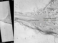 Lethe Vallis, as seen by HiRISE. Flow was from southwest to northeast. Wider part of Lethe Vallis had less erosive power, so mesas are left behind from pre-existing material. Scale bar is 500 meters long. | |
| Coordinates | 4°00′N 206°30′W / 4°N 206.5°W |
|---|---|
References edit
- ^ "Lethe Vallis". Gazetteer of Planetary Nomenclature. USGS Astrogeology Research Program.
- ^ Balme M. R.; et al. (2011). "Fill and spill in Lethe Vallis: a recent flood-routing system in Elysium Planitia, Mars". In M. R. Balme; A. S. Bargery; C. J. Gallagher; S. Gupta (eds.). Martian Geomorphology. Geological Society, London, Special Publications, vol. 356, issue 1. Vol. 356. MPG Books. pp. 203–227. Bibcode:2011GSLSP.356..203B. doi:10.1144/SP356.11. ISBN 9781862393301. S2CID 131101019.
{{cite book}}:|journal=ignored (help)