


Summary
Jombang Regency (Indonesian: Kabupaten Jombang; Javanese: ꦏꦧꦸꦥꦠꦺꦤ꧀ꦗꦺꦴꦩ꧀ꦧꦁ) is a regency of East Java, Indonesia, situated to the southwest of Surabaya. The capital of the regency is the town of Jombang. The regency has an area of 1,159.50 km2 and a population of 1,202,407 at the 2010 census[2] and 1,318,062 at the 2020 census;[3] the official estimate as of mid-2023 was 1,370,510 (comprising 690,361males and 680,149 females).[1] It became a regency in 1910. It was the birthplace of Abdurrahman Wahid, the 4th president of Indonesia.
Jombang Regency
Kabupaten Jombang ꦏꦧꦸꦥꦠꦺꦤ꧀ꦗꦺꦴꦩ꧀ꦧꦁ | |
|---|---|
 | |
 Coat of arms | |
 Location within East Java | |
| Coordinates: 7°28′S 112°14′E / 7.467°S 112.233°E | |
| Country | |
| Province | East Java |
| Capital | Jombang |
| Government | |
| • Regent | Mundjidah Wahab |
| • Vice Regent | vacant |
| Area | |
| • Total | 1,159.50 km2 (447.69 sq mi) |
| Population (mid 2023 estimate)[1] | |
| • Total | 1,370,510 |
| • Density | 1,200/km2 (3,100/sq mi) |
| Time zone | UTC+7 (IWST) |
| Area code | (+62) 321 |
| Website | jombangkab |


Administrative districts edit
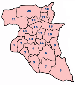
The regency is divided administratively into twenty-one districts (kecamatan), tabulated below with their areas and population totals from the 2010 census[2] and the 2020 census,[3] together with the official estimates as of mid-2023.[1] The table also includes the locations of the district administrative centres, the number of administrative villages in each district (comprising 302 rural desa and 4 urban kelurahan - the latter all in Jombang (town) District), and its postal codes.
| Kode Wilayah |
Name of District (kecamatan) |
No. on map |
Area in km2 |
Pop'n census 2010 |
Pop'n census 2020 |
Pop'n estimate mid 2023 |
Admin centre |
No. of villages |
Post codes |
|---|---|---|---|---|---|---|---|---|---|
| 35.17.18 | Bandar Kedung Mulyo | 1 | 32.50 | 43,193 | 49,959 | 52,604 | Banjarsari | 11 | 61462 |
| 35.17.01 | Perak | 2 | 29.05 | 50,876 | 55,975 | 59,098 | Perak | 13 | 61461 |
| 35.17.02 | Gudo | 3 | 34.39 | 50,471 | 55,997 | 58,822 | Gudo | 18 | 61463 |
| 35.17.08 | Diwek | 4 | 47.70 | 100,969 | 110,495 | 114,020 | Diwek | 20 | 61471 |
| 35.17.03 | Ngoro | 5 | 49.86 | 68,863 | 77,814 | 80,348 | Ngoro | 13 | 61473 |
| 35.17.07 | Mojowarno | 6 | 78.62 | 85,619 | 95,660 | 99,451 | Mojowarno | 19 | 61475 |
| 35.17.04 | Bareng | 7 | 94.27 | 49,470 | 56,539 | 59,428 | Bareng | 13 | 61474 |
| 35.17.05 | Wonosalam | 8 | 121.63 | 30,609 | 33,520 | 35,059 | Wonosalam | 9 | 61476 |
| 35.17.06 | Mojoagung | 9 | 60.18 | 73,004 | 81,051 | 83,844 | Gambiran | 18 | 61482 |
| 35.17.11 | Sumobito | 10 | 47.64 | 77,039 | 86,385 | 90,223 | Sumobito | 21 | 61483 |
| 35.17.19 | Jogoroto | 11 | 28.28 | 62,943 | 70,760 | 74,082 | Jogoroto | 11 | 61485 |
| 35.17.10 | Peterongan | 12 | 29.47 | 63,784 | 67,822 | 70,502 | Peterongan | 14 | 61481 |
| 35.17.09 | Jombang (town) |
13 | 36.40 | 137,233 | 139,831 | 143,301 | Jombatan | 20 (a) | 61411 - 61419 |
| 35.17.20 | Megaluh | 14 | 28.41 | 36,507 | 39,725 | 41,502 | Megaluh | 13 | 61457 |
| 35.17.13 | Tembelang | 15 | 32.94 | 49,371 | 54,891 | 57,135 | Pesantren | 15 | 61452 |
| 35.17.12 | Kesamben | 16 | 51.72 | 59,990 | 66,861 | 68,829 | Kesamben | 14 | 61484 |
| 35.17.17 | Kudu | 17 | 77.75 | 28,239 | 31,513 | 32,868 | Randuwatang | 11 | 61454 |
| 35.17.21 | Ngusikan | 18 | 34.96 | 20,928 | 22,793 | 23,768 | Ngusikan | 11 | 61450 |
| 35.17.14 | Ploso | 19 | 25.96 | 38,792 | 41,727 | 43,430 | Ploso | 13 | 61453 |
| 35.17.16 | Kabuh | 20 | 97.35 | 39,099 | 41,311 | 43,376 | Karangpaku | 16 | 61455 |
| 35.17.15 | Plandaan | 21 | 120.40 | 35,408 | 37,383 | 38,820 | Bangsri | 13 | 61456 |
| Totals | 1,159.50 | 1,202,407 | 1,318,062 | 1,370,510 | Jombang | 306 |
Note: (a) comprising 4 urban kelurahan (Jombatan, Jelakombo, Kaliwungu and Kepanjen) and 16 desa.
The five last-mentioned districts in the table constitute the folded limestone hilly region in the north, separated from the rest of the regency by the Brantas River. The rest of the regency to the south of the river is more low-lying and constitutes good agricultural land, although the south-east corner (Ngoro, Mojowarno, Bareng and Wonosalam Districts) is more mountainous.
Climate edit
| Climate data for Jombang Regency | |||||||||||||
|---|---|---|---|---|---|---|---|---|---|---|---|---|---|
| Month | Jan | Feb | Mar | Apr | May | Jun | Jul | Aug | Sep | Oct | Nov | Dec | Year |
| Mean daily maximum °C (°F) | 33 (91) |
32 (90) |
33 (91) |
32 (90) |
31 (88) |
31 (88) |
30 (86) |
31 (88) |
32 (90) |
33 (91) |
35 (95) |
33 (91) |
32.2 (90.0) |
| Daily mean °C (°F) | 29 (84) |
28 (82) |
29 (84) |
28 (82) |
27 (81) |
27 (81) |
27 (81) |
27 (81) |
27 (81) |
28 (82) |
30 (86) |
29 (84) |
28 (82) |
| Mean daily minimum °C (°F) | 25 (77) |
25 (77) |
25 (77) |
25 (77) |
24 (75) |
24 (75) |
23 (73) |
23 (73) |
22 (72) |
24 (75) |
26 (79) |
25 (77) |
24.3 (75.7) |
| Average rainfall mm (inches) | 223 (8.8) |
221 (8.7) |
198 (7.8) |
237 (9.3) |
147 (5.8) |
181 (7.1) |
37 (1.5) |
20 (0.8) |
5 (0.2) |
29 (1.1) |
80 (3.1) |
280 (11.0) |
138.2 (5.44) |
| Average rainy days | 15 | 10 | 10 | 8 | 7 | 7 | 4 | 0 | 0 | 1 | 8 | 14 | 84 |
| Average relative humidity (%) | 71 | 79.78 | 78.32 | 82.83 | 74.16 | 69.7 | 66.61 | 68.03 | 64.23 | 64.22 | 64.3 | 72.8 | 71.3 |
| Source 1: "Weather Forecast & Reports - Long Range & Local | Wunderground | Weather Underground". www.wunderground.com. Retrieved 2016-04-12. | |||||||||||||
| Source 2: "Badan Pusat Statistik Kabupaten Jombang". jombangkab.bps.go.id. Archived from the original on 2016-04-23. Retrieved 2016-04-12. | |||||||||||||
| Month | Jan | Feb | Mar | Apr | May | Jun | Jul | Aug | Sep | Oct | Nov | Dec | Year |
| Maximum wind speed (km/h) | 58 | 69 | 60 | 48 | 45 | 29 | 60 | 63 | 182 | 138 | 29 | 40 | 68.42 |
| Average wind speed (km/h) | 45 | 48 | 45 | 48 | 42 | 11 | 14 | 14 | 14 | 15 | 11 | 11 | 26.5 |
| Minimum Wind Speed (km/h) | 26 | 29 | 37 | 48 | 40 | 0 | 0 | 0 | 0 | 0 | 0 | 0 | 15 |
| Minimum humidity (%) | 55 | 57.89 | 59.48 | 62.67 | 56.58 | 53.03 | 49.16 | 47.77 | 41.07 | 39.06 | 40.47 | 48.93 | 50.92 |
References edit
External links edit
- (in Indonesian) Official site