
KNOWPIA
WELCOME TO KNOWPIA

Islands Region 
Summary
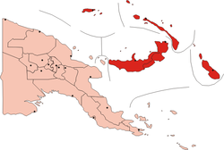
The New Guinea Islands Region is one of four regions of Papua New Guinea (PNG), comprising the Bismarck Archipelago and north-western Solomon Islands Archipelago, located north-east of New Guinea island (the mainland).
New Guinea Islands Region | |
|---|---|
 | |
| Coordinates: 4°21′S 152°16′E / 4.350°S 152.267°E | |
| Country | |
| Largest city | Arawa |
| Area | |
| • Total | 56,602 km2 (21,854 sq mi) |
| Population (2011)[1] | |
| • Total | 1,096,543 |
| • Density | 19/km2 (50/sq mi) |
| Time zone | UTC+10:00 (PNGST) |
This is the least populous inhabited region of the country with an estimated population of 1,096,000 (15% of PNG) in 2011.[2]
It is distinct through its prehistory and history, as shown by the prevalence of Austronesian languages, and archeological findings of Lapita pottery culture.
Subdivision edit
The Region is administratively divided into five provinces:
- Bougainville (North Solomons)
- East New Britain
- Manus
- New Ireland
- West New Britain
See also edit
References edit