


Summary
The Hume is an economic rural region[2] located in the north-eastern part of Victoria, Australia.[3] Comprising an area in excess of 40,000 square kilometres (15,000 sq mi) with a population that has grown from 263,000 (in 2011) to 309,684 (in 2021), the Hume region includes the local government areas of Alpine Shire, Rural City of Benalla, City of Wodonga, City of Greater Shepparton, Shire of Indigo, Shire of Mansfield, Shire of Strathbogie, Shire of Towong and the Rural City of Wangaratta, and also includes five unincorporated areas encompassing the alpine ski resorts in the region.
| Hume Region Victoria | |||||||||||||||
|---|---|---|---|---|---|---|---|---|---|---|---|---|---|---|---|
 | |||||||||||||||
 Victorian Alps pictured in Spring 2007. | |||||||||||||||
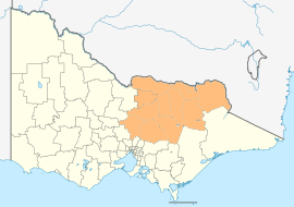
 Hume Region The location of Shepparton, a city in the Hume region | |||||||||||||||
| Coordinates | 36°23′S 145°24′E / 36.383°S 145.400°E | ||||||||||||||
| Population | 309,684 (2021 census)[Note 1] | ||||||||||||||
| • Density | 7.66905/km2 (19.86275/sq mi) | ||||||||||||||
| Area | 40,381 km2 (15,591.2 sq mi)[Note 2][1] | ||||||||||||||
| LGA(s) |
| ||||||||||||||
| State electorate(s) | |||||||||||||||
| Federal division(s) | |||||||||||||||
| Website | Hume Region | ||||||||||||||
| |||||||||||||||
The Hume region is located along the two major interstate transport corridors – the Hume corridor and the Goulburn Valley corridor. The region comprises four distinct and inter-connected sub-regions or districts: Upper Hume, Central Hume, Goulburn Valley, and Lower Hume. The regional cities and centres of Wodonga, Shepparton and Wangaratta (supported by Benalla) function as a network of regional hubs that service their own distinct sub-regions. The region is bounded by the Victorian Alps in the south and east, the New South Wales border defined by the Murray River in the north, the Loddon Mallee region in the west and the Greater Melbourne northern, western, and eastern metropolitan and Gippsland regions to the south.[4]
Administration edit
Political representation edit
For the purposes of Australian federal elections for the House of Representatives, the Hume region is contained within all or part of the electoral divisions of Bendigo,[5] Indi,[6] McEwen,[7] and Nicholls.[8]
For the purposes of Victorian elections for the Legislative Assembly, the Hume region is contained within all or part of the electoral districts of Benambra, Eildon, Euroa, Ovens Valley, and Shepparton.
Local government areas edit
The region contains twelve local government areas and five unincorporated areas of Victoria, which are:
| Local government area | Area | Population (2016 census) |
Source(s) | Population (2021 census) |
Source(s) | |
|---|---|---|---|---|---|---|
| km2 | sq mi | |||||
| Alpine Shire | 4,787 | 1,848 | 12,337 | [9] | 13,235 | [10] |
| Rural City of Benalla | 2,345 | 905 | 13,861 | [11] | 14,528 | [12] |
| Shire of Indigo | 2,044 | 789 | 15,952 | [13] | 17,368 | [14] |
| Shire of Mansfield | 3,843 | 1,484 | 8,584 | [15] | 10,178 | [16] |
| Shire of Mitchell | 2,864 | 1,106 | 40,918 | [17] | 49,460 | [18] |
| Shire of Moira | 4,045 | 1,562 | 29,112 | [19] | 30,522 | [20] |
| Shire of Murrindindi | 3,889 | 1,502 | 13,732 | [21] | 15,197 | [22] |
| City of Greater Shepparton | 2,422 | 935 | 63,837 | [23] | 68,409 | [24] |
| Shire of Strathbogie | 3,302 | 1,275 | 10,274 | [25] | 11,455 | [26] |
| Shire of Towong | 6,673 | 2,576 | 5,985 | [27] | 6,223 | [28] |
| Rural City of Wangaratta | 3,639 | 1,405 | 28,310 | [29] | 29,808 | [30] |
| City of Wodonga | 433 | 167 | 39,351 | [31] | 43,253 | [32] |
| Totals | 40,286 | 15,555 | 282,253 | 309,363 | ||
| Unincorporated area | Area | Population (2021 census) |
Source(s) | |
|---|---|---|---|---|
| km2 | sq mi | |||
| Falls Creek Alpine Resort | 15.5 | 6.0 | 321 | [33] |
| Lake Mountain Alpine Resort | unknown | Nil | ||
| Mount Buller Alpine Resort | 22.6 | 8.7 | Nil | |
| Hotham Alpine Resort | 29.1 | 11.2 | Nil | |
| Mount Stirling Alpine Resort | 28.2 | 10.9 | Nil | |
| Totals | 95.4 | 36.8 | 321 | |
| LGAs and Unincorporated areas | Area | Population (2021 census) | |
|---|---|---|---|
| km2 | sq mi | ||
| Total local government areas | 40,286 | 15,555 | 309,363 |
| Total unincorporated areas | 95.4 | 36.8 | 321 |
| Totals | 40,381 | 15,591 | 309,684 |
Environmental protection edit
The Hume region contains many protected areas such as Barmah, Burrowa-Pine Mountain and Chiltern-Mt Pilot national parks; and the Winton Wetlands restoration site.
See also edit
Notes edit
References edit
- ^ Hume Region Local Government Network; Hume Regional Management Forum; Hume Regional Development Australia Committee (August 2012). State of the Hume Region 2010–2012 (PDF). Urban Development Division, Department of Planning and Community Development, State Government of Victoria. p. 6. ISBN 978-1-921940-57-6. Archived from the original (PDF) on 1 February 2014. Retrieved 21 January 2014.
- ^ "Meaning of Regional Victoria". Department of State Development, Business and Innovation (MS Word requires download). State Government of Victoria. 2011. Archived from the original on 19 August 2014. Retrieved 15 August 2014.
- ^ "Victoria's Hume Region". Regional Development Victoria. State Government of Victoria. 8 May 2014. Retrieved 10 August 2014.
- ^ "Hume Regional Growth Plan". Department of Transport, Planning and Local Infrastructure. Government of Victoria. 5 August 2013. Retrieved 21 January 2014.
- ^ "Profile of the electoral division of Bendigo (Vic)". Current federal electoral divisions. Australian Electoral Commission. 24 December 2010. Retrieved 16 August 2014.
- ^ "Profile of the electoral division of Indi (Vic)". Current federal electoral divisions. Australian Electoral Commission. 24 December 2010. Retrieved 16 August 2014.
- ^ "Profile of the electoral division of McEwen (Vic)". Current federal electoral divisions. Australian Electoral Commission. 24 December 2010. Retrieved 15 August 2014.
- ^ "Profile of the electoral division of Nicholls (Vic)". Current federal electoral divisions. Australian Electoral Commission. 13 October 2021. Retrieved 23 February 2022.
- ^ Australian Bureau of Statistics (27 June 2017). "2016 Community Profiles: Alpine (S) (Local Government Area)". 2016 Census of Population and Housing. Retrieved 8 December 2020.
- ^ Australian Bureau of Statistics (28 June 2022). "2021 Community Profiles: Alpine (S) (Local Government Area)". 2021 Census of Population and Housing. Retrieved 17 November 2023.
- ^ Australian Bureau of Statistics (27 June 2017). "2016 Community Profiles: Benalla (RC) (Local Government Area)". 2016 Census of Population and Housing. Retrieved 8 December 2020.
- ^ Australian Bureau of Statistics (28 June 2022). "2021 Community Profiles: Benalla (RC) (Local Government Area)". 2021 Census of Population and Housing. Retrieved 17 November 2023.
- ^ Australian Bureau of Statistics (27 June 2017). "2016 Community Profiles: Indigo (S) (Local Government Area)". 2016 Census of Population and Housing. Retrieved 8 December 2020.
- ^ Australian Bureau of Statistics (28 June 2022). "2021 Community Profiles: Indigo (S) (Local Government Area)". 2021 Census of Population and Housing. Retrieved 17 November 2023.
- ^ Australian Bureau of Statistics (27 June 2017). "2016 Community Profiles: Mansfield (S) (Local Government Area)". 2016 Census of Population and Housing. Retrieved 8 December 2020.
- ^ Australian Bureau of Statistics (28 June 2022). "2021 Community Profiles: Mansfield (S) (Local Government Area)". 2021 Census of Population and Housing. Retrieved 19 November 2023.
- ^ Australian Bureau of Statistics (27 June 2017). "2016 Community Profiles: Mitchell (S) (Local Government Area)". 2016 Census of Population and Housing. Retrieved 8 December 2020.
- ^ Australian Bureau of Statistics (28 June 2022). "2021 Community Profiles: Mitchell (S) (Local Government Area)". 2021 Census of Population and Housing. Retrieved 19 November 2023.
- ^ Australian Bureau of Statistics (27 June 2017). "2016 Community Profiles: Moira (S) (Local Government Area)". 2016 Census of Population and Housing. Retrieved 8 December 2020.
- ^ Australian Bureau of Statistics (28 June 2022). "2021 Community Profiles: Moira (S) (Local Government Area)". 2021 Census of Population and Housing. Retrieved 19 November 2023.
- ^ Australian Bureau of Statistics (27 June 2017). "2016 Community Profiles: Murrindindi (S) (Local Government Area)". 2016 Census of Population and Housing. Retrieved 8 December 2020.
- ^ Australian Bureau of Statistics (28 June 2022). "2021 Community Profiles: Murrindindi (S) (Local Government Area)". 2021 Census of Population and Housing. Retrieved 19 November 2023.
- ^ Australian Bureau of Statistics (27 June 2017). "2016 Community Profiles: Greater Shepparton (C) (Local Government Area)". 2016 Census of Population and Housing. Retrieved 8 December 2020.
- ^ Australian Bureau of Statistics (28 June 2022). "2021 Community Profiles: Greater Shepparton (C) (Local Government Area)". 2021 Census of Population and Housing. Retrieved 19 November 2023.
- ^ Australian Bureau of Statistics (27 June 2017). "2016 Community Profiles: Strathbogie (S) (Local Government Area)". 2016 Census of Population and Housing. Retrieved 8 December 2020.
- ^ Australian Bureau of Statistics (28 June 2022). "2021 Community Profiles: Strathbogie (S) (Local Government Area)". 2021 Census of Population and Housing. Retrieved 19 November 2023.
- ^ Australian Bureau of Statistics (27 June 2017). "2016 Community Profiles: Towong (S) (Local Government Area)". 2016 Census of Population and Housing. Retrieved 8 December 2020.
- ^ Australian Bureau of Statistics (28 June 2022). "2021 Community Profiles: Towong (S) (Local Government Area)". 2021 Census of Population and Housing. Retrieved 19 November 2023.
- ^ Australian Bureau of Statistics (27 June 2017). "2016 Community Profiles: Wangaratta (RC) (Local Government Area)". 2016 Census of Population and Housing. Retrieved 8 December 2020.
- ^ Australian Bureau of Statistics (28 June 2022). "2021 Community Profiles: Wangaratta (RC) (Local Government Area)". 2021 Census of Population and Housing. Retrieved 19 November 2023.
- ^ Australian Bureau of Statistics (27 June 2017). "2016 Community Profiles: Wodonga (C) (Local Government Area)". 2016 Census of Population and Housing. Retrieved 8 December 2020.
- ^ Australian Bureau of Statistics (28 June 2022). "2021 Community Profiles: Wodonga (C) (Local Government Area)". 2021 Census of Population and Housing. Retrieved 19 November 2023.
- ^ Australian Bureau of Statistics (28 June 2022). "2021 Community Profiles: Falls Creek Alpine Resort (Statistical Local Area)". 2021 Census of Population and Housing. Retrieved 19 November 2021.
External links edit
- "Hume region". Regional Development Victoria. Government of Victoria. 14 October 2013.
- State of the Hume Region 2010–2012 (PDF). Urban Development Division, Department of Planning and Community Development, Government of Victoria. August 2012. ISBN 978-1-921940-57-6. Archived from the original (PDF) on 1 February 2014. Retrieved 21 January 2014.
- "Draft Regional Growth Plan: Hume region" (PDF). Department of Planning and Community Development, Government of Victoria. June 2013.