


Summary
Himawari 8 (ひまわり8号) is a Japanese weather satellite, the 8th of the Himawari geostationary weather satellites operated by the Japan Meteorological Agency. The spacecraft was constructed by Mitsubishi Electric with assistance from Boeing, and is the first of two similar satellites to be based on the DS2000 satellite bus.[3] Himawari 8 entered operational service on 7 July 2015 and is the successor to MTSAT-2 (Himawari 7) which was launched in 2006.
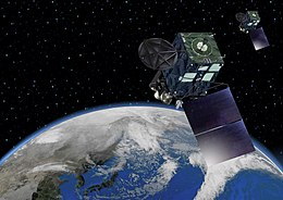 Rendering of Himawari 8 and 9 | |
| Mission type | Weather satellite |
|---|---|
| Operator | JMA |
| COSPAR ID | 2014-060A |
| SATCAT no. | 40267 |
| Mission duration | 8 years (planned) |
| Spacecraft properties | |
| Bus | DS2000 |
| Manufacturer | Mitsubishi Electric |
| Launch mass | 3500 kg |
| Dry mass | 1300 kg |
| Power | 2.6 kilowatts from solar array |
| Start of mission | |
| Launch date | 7 October 2014, 05:16 UTC |
| Rocket | H-IIA 202 |
| Launch site | Tanegashima LA-Y1 |
| Contractor | Mitsubishi Heavy Industries |
| Entered service | 7 July 2015, 02:00 UTC[1] |
| Orbital parameters | |
| Reference system | Geocentric |
| Regime | Geostationary |
| Longitude | 140.7° East |
| Perigee altitude | 35,791 km (22,239 mi)[2] |
| Apogee altitude | 35,795 km (22,242 mi)[2] |
| Inclination | 0.03 degrees[2] |
| Period | 1436.13 minutes[2] |
| Epoch | 22 January 2015, 22:13:28 UTC[2] |
Launch edit
Himawari 8 was launched atop a H-IIA rocket flying from the Yoshinobu Launch Complex Pad 1 at the Tanegashima Space Center.[4] The launch occurred at 05:16 UTC on 7 October 2014 and reached its operational geostationary orbit in October 2014, at 35,786 kilometers[5] and 140.7 degrees East.[6]
Himawari 9, which is identical to Himawari 8, was launched on 2 November 2016 and placed in a stand-by orbit until 05:00 UTC by 13 December 2022, when it succeeded Himawari 8.[7][8]
Purpose edit
The role of Himawari 8 is to provide typhoon, rainstorm, weather forecast and other related reports for Japan, East Asia, and Western Pacific region. It is also responsible for ensuring the safety of ships, aviation and observing the environment of the earth.[9]
Its temporal and spatial resolution enables it to observe disastrous events in remote places, such as volcanic eruptions. The Himawari satellite was able to capture the Tianjin explosions in 2015,[10] and the Hunga Tonga–Hunga Ha'apai eruption in 2022.[11]
Data recorded from the Japanese Himawari 8 will be made freely available for use by meteorological agencies in other countries.[12]
Design edit
The DS2000 satellite bus has a lifespan of 15 years, however the expected operational lifespan of Himawari 8 is expected to be limited by its instruments which are only designed for 8 years of service. At launch, the mass of the satellite was about 3,500 kilograms (7,700 lb). Power is supplied by a single gallium arsenide solar panel, which provides up to 2.6 kilowatts of power.[13]
Instruments edit
The primary instrument aboard Himawari 8, the Advanced Himawari Imager (AHI), is a 16 channel multispectral imager to capture visible light and infrared images of the Asia-Pacific region.[13] The instrument was designed and built by Exelis Geospatial Systems (now Harris Space & Intelligence Systems) and has similar spectral and spatial characteristics to the Advanced Baseline Imager (ABI) used in the American GOES-16, -17, -T, and -U satellites. The AHI can produce images with a resolution down to 500m and can provide full disk observations every 10 mins and images of Japan every 2.5 minutes.[13] The Australian Bureau of Meteorology CEO Dr Rob Vertessy stated that Himawari 8 "generates about 50 times more data than the previous satellite".[12] A recent study reported that Himawari-8 had acquired cloud-free observations every 4 days, while capturing the seasonal changes of vegetation in the cloud-prone region of Southeast Asia more accurately than before.[14]
| Wavelength
(μm) |
Band
number |
Spatial
resolution at SSP (km) |
Central wavelength (μm) |
|---|---|---|---|
| 0.47 | 1 | 1 | 0.47063 |
| 0.51 | 2 | 1 | 0.51000 |
| 0.64 | 3 | 0.5 | 0.63914 |
| 0.86 | 4 | 1 | 0.85670 |
| 1.6 | 5 | 2 | 1.6101 |
| 2.3 | 6 | 2 | 2.2568 |
| 3.9 | 7 | 2 | 3.8853 |
| 6.2 | 8 | 2 | 6.2429 |
| 6.9 | 9 | 2 | 6.9410 |
| 7.3 | 10 | 2 | 7.3467 |
| 8.6 | 11 | 2 | 8.5926 |
| 9.6 | 12 | 2 | 9.6372 |
| 10.4 | 13 | 2 | 10.4073 |
| 11.2 | 14 | 2 | 11.2395 |
| 12.4 | 15 | 2 | 12.3806 |
| 13.3 | 16 | 2 | 13.2807 |
The Space Environmental Data Acquisition Monitor (SEDA) is the second instrument aboard Himawari 8, and it consists of two sensors: SEDA-e for detecting high energy electrons and SEDA-p for detecting high energy protons.[16] SEDA-e is a single element with 8 stacked charge collecting plates.[17] It has an energy range of 0.2-4.5 MeV and a field of view of ±78.3°.[16] SEDA-p consists of 8 separate proton telescope elements.[17] In total, SEDA-e has an energy range of 15-100 MeV and a field of view of ±39.35°. Both sensors have a time resolution of 10 seconds.[16] The data from this instrument is transmitted to a ground station in Saitama, Japan with a Ka-band signal and is ultimately provided to the National Institute of Information and Communications Technology (NICT) for use monitoring space weather events along the Japanese meridian.[16][18]
Gallery edit
-
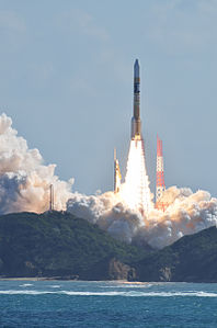 Liftoff of the H-IIA rocket carrying Himawari 8 on October 7, 2014
 -
 The first true-color PNG image from Himawari 8 on January 25, 2015
 -
 Example of a Rayleigh-corrected, true-color full disk image created from the AHI sensor


References edit
- ^ "静止気象衛星「ひまわり8号」の運用開始日について" (in Japanese). Japan Meteorological Agency. Retrieved 27 May 2015.
- ^ a b c d e Peat, Chris (22 January 2015). "HIMAWARI 8 - Orbit". Heavens-Above. Retrieved 25 January 2015.
- ^ Graham, William (6 October 2014). "Japan lofts Himawari 8 weather satellite via H-IIA rocket". NASASpaceflight.com. Retrieved 7 October 2014.
- ^ Clark, Stephen. "H-2A rocket boosts Japanese weather satellite into orbit". Spaceflight Now. Retrieved 7 October 2014.
- ^ "Satellite: Himawari-8". OSCAR.
- ^ "JMA/MSC: Himawari-8/9". Japan Meteorological Agency. Archived from the original on 23 September 2015. Retrieved 7 October 2014.
- ^ 衛星観測は「ひまわり8号」から「ひまわり9号」へ (in Japanese). Japan Meteorological Agency. 11 November 2022. Retrieved 11 November 2022.
- ^ "Meteorological Satellite Center (MSC) | Switchover of the Operational Satellite". www.data.jma.go.jp. Japan Meteorological Agency. Retrieved 12 November 2022.
- ^ "New geostationary meteorological satellites — Himawari-8/9 —" (PDF). 19 May 2016. Archived from the original (PDF) on 19 May 2016. Retrieved 27 February 2020.
- ^ "Tianjin explosions visible from space". The Guardian. 13 August 2015. Retrieved 28 March 2019.
- ^ "Tsunami hits Tonga after massive volcano eruption seen from space". YouTube.
- ^ a b "Spectacular new era in satellite meteorology unveiled". Australian Bureau of Meteorology. Commonwealth of Australia. 30 September 2015. Retrieved 30 September 2015.
- ^ a b c "New geostationary meteorological satellites — Himawari-8/9 —" (PDF). Japan Meteorological Agency. Retrieved 7 October 2014.
- ^ Miura, Tomoaki; Nagai, Shin; Takeuchi, Mika; Ichii, Kazuhito; Yoshioka, Hiroki (30 October 2019). "Improved Characterisation of Vegetation and Land Surface Seasonal Dynamics in Central Japan with Himawari-8 Hypertemporal Data". Scientific Reports. 9 (1): 15692. Bibcode:2019NatSR...915692M. doi:10.1038/s41598-019-52076-x. ISSN 2045-2322. PMC 6821777. PMID 31666582.
- ^ "JMA/MSC: Himawari-8/9 Imager (AHI)". www.data.jma.go.jp. Retrieved 4 March 2020.
- ^ a b c d Nagatsuma, Tsutomu; Sakaguchi, Kaori; Kubo, Yûki; Belgraver, Piet; Chastellain, Frédéric; Muff, Reto; Otomo, Takeshi (2017). "Space environment data acquisition monitor onboard Himawari-8 for space environment monitoring on the Japanese meridian of geostationary orbit". Earth, Planets and Space. 69 (1): 75. Bibcode:2017EP&S...69...75N. doi:10.1186/s40623-017-0659-6. S2CID 54863699.
- ^ a b Jiggens, P.; Clavie, C.; Evans, H.; O'Brien, T. P.; Witasse, O.; Mishev, A. L.; Nieminen, P.; Daly, E.; Kalegaev, V.; Vlasova, N.; Borisov, S. (2019). "In Situ Data and Effect Correlation During September 2017 Solar Particle Event". Space Weather. 17 (1): 99–117. Bibcode:2019SpWea..17...99J. doi:10.1029/2018SW001936. ISSN 1542-7390.
- ^ Bessho, Kotaro; Date, Kenji; Hayashi, Masahiro; Ikeda, Akio; Imai, Takahito; Inoue, Hidekazu; Kumagai, Yukihiro; Miyakawa, Takuya; Murata, Hidehiko; Ohno, Tomoo; Okuyama, Arata (2016). "An Introduction to Himawari-8/9— Japan's New-Generation Geostationary Meteorological Satellites". Journal of the Meteorological Society of Japan. Series II. 94 (2): 151–183. Bibcode:2016JMeSJ..94..151B. doi:10.2151/jmsj.2016-009.
External links edit
 Media related to Himawari 8 images at Wikimedia Commons
- Meteorological Satellites of JMA
- JMA Satellite Imagery, providing infrared, vapor and true-color Himawari 8 imageries every 30 minutes
- Himawari-8 Real-time Web from NICT, providing full-disc pictures of true color and all 16 bands every 10 minutes
- RealEarth including imageries from all 16 bands of Himawari 8
- Himawari-8 - Third-Generation Weather Satellite from Digital Typhoon
- Himawari 8 3D model from Asahi Shinbun
- Glittering Blue Time lapsed imagery from Himawari 8
- A Year Along the Geostationary Orbit on Vimeo. An animation made from visible and infrared images taken by Himawari 8 from December 21, 2015, to December 21, 2016.