


Summary
The Town of Danville[11] is located in the San Ramon Valley in Contra Costa County, California, United States. It is one of the incorporated municipalities in California that use "town" in their names instead of "city". The population was 43,582 at the 2020 census. Since 2018, for five years in a row, Danville was named "the safest town in California".[12][13]
Town of Danville | |
|---|---|
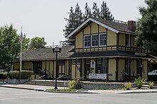
 Museum of the San Ramon Valley, pictured in 2021. | |
| Motto(s): | |
 Location of Danville in Contra Costa County, California. | |
 Town of Danville Location in the United States | |
| Coordinates: 37°49′18″N 122°00′00″W / 37.82167°N 122.00000°W | |
| Country | United States |
| State | California |
| County | Contra Costa |
| Incorporated | July 1, 1982[2] |
| Government | |
| • Mayor | Karen Stepper[3] |
| • State senator | Steve Glazer (D)[4] |
| • Assemblymember | Rebecca Bauer-Kahan (D)[5] |
| • United States representatives | Mark DeSaulnier (D) [6] |
| Area | |
| • Total | 18.08 sq mi (46.82 km2) |
| • Land | 18.08 sq mi (46.82 km2) |
| • Water | 0.00 sq mi (0.00 km2) 0% |
| Elevation | 358 ft (109 m) |
| Population (2020) | |
| • Total | 43,582 |
| • Density | 2,410.78/sq mi (930.82/km2) |
| Time zone | UTC-8 (Pacific) |
| • Summer (DST) | UTC-7 (PDT) |
| ZIP codes | 94506, 94526 |
| Area code | 925 |
| FIPS code | 06-17988 |
| GNIS feature IDs | 277497[9] 2412403[10] |
| Website | www |
The Iron Horse Regional Trail runs through Danville. It was first a railroad that has been converted to an 80-foot (24 m) wide [citation needed] corridor of bike and hike trails as well as controlled intersections. Extending from Livermore to Concord, the trail passes through Danville.[14]
Danville is also home to the Eugene O'Neill National Historic Site, Village Theatre and Art Gallery, and the Museum of the San Ramon Valley.[15]
History edit

Often referred to as the "Heart of the San Ramon Valley," Danville was first populated by Native Americans who lived near creeks and camped on Mount Diablo in the summer. Later, it was part of Mission San José's grazing land as well as a Mexican land grant called Rancho San Ramon.
Initially a farming community, the Town of Danville switched from wheat to fruits and nuts after the Southern Pacific Railroad built a spur line through the area in 1891. It developed as a residential suburb in 1947 when the first sizable housing tracts were constructed and its population boomed in the 1970s and 1980s.[16]
The Danville Post Office opened in 1860 with hotel owner Henry W. Harris as the first postmaster.[17]
Churches, schools, farmers unions and fraternal lodges began as the community grew. The Union Academy, a private high school begun by the Cumberland Presbyterian Church, served the county from 1859 to 1868, until it burned down. Danville Presbyterian Church was dedicated in 1875.
Many early Danville buildings remain standing today. The original 1874 Grange Hall exists as well, and the original Danville Hotel remains downtown which was last renovated in 2016.[18] Many of the early pioneer names appear on the streets and schools, including Baldwin, Harlan, Wood, Love, Hemme, Boone, Bettencourt and Meese.[1]
When the Southern Pacific Railroad came to the Valley in 1891, Danville continued to grow. Farmers built warehouses and shipped crops by rail, and residents were able to travel to and from Danville.[1]
John Hartz sold 8.65 acres (3.50 ha) of his land for the Danville Depot and granted land access to the station. He then subdivided and sold lots east of the station, shifting the town's focus from Front Street to Hartz Avenue. Eventually, a bank, drug store, saloon, doctor's office and Chinese laundry joined the houses lining the street. The Danville Hotel originally sat across from the station and was moved to face Hartz avenue in 1927.[19]
The twentieth century found Danville affected by the wars, the Spanish flu, the depression, and new immigrants.
In 1910, a public high school district was organized and San Ramon Valley Union High School was built. A library opened in 1913 with 104 books. St. Isidore's Catholic Church was first established in 1910. An Improvement League funded the first streetlights and paved roads in 1915.
Danville continued as farm country into the 1940s. The Valley had a population of 2,120 people in 1940, growing to 4,630 by 1950. Developments such as Montair and Cameo Acres were built, the water and sewer districts extended their boundaries, and the new I-680 freeway which cut through Danville in the mid-1960.
In 1982, Danville citizens voted to incorporate their community.
In 2000, Danville's population reached 40,484.
Danville was ranked as the safest city in California for a fifth year in a row, most recently in 2022.[12][13][20]
Geography edit

Danville is set in a narrow section of the San Ramon Valley[21] with the Las Trampas Ridge to the west and the Diablo Range to the east. The most prominent landmark of Danville is the backdrop of Mount Diablo, which stands to the east at 3,849 feet (1,173 m) and provides a picturesque backdrop for Danville and neighboring towns and cities. Sycamore Creek drains some of the Mount Diablo slopes and flows through Danville.
To the north of Danville, the unincorporated town of Alamo sits in the uppermost reaches of the San Ramon Valley and extends into the surrounding hills. San Ramon, another affluent suburb, borders Danville to the south.
Interstate 680, extending along the valley to the north and south, is the main route used by traffic in and out of town. Camino Tassajara is the main thoroughfare for east–west travel, most importantly to reach the eastern subdivisions far from the interstate. Camino Tassajara also provides access to the wealthy gated community of Blackhawk.
According to the United States Census Bureau, the town has a total area of 18.0 square miles (47 km2), all of it land.
Climate edit
Danville's weather typifies a Mediterranean climate. Summers are long, with hot days and cool nights. Winters are cool, with mild daytime temperatures usually in the 50s, and nighttime temperatures usually above freezing. Like in the rest of the Bay Area, summers in Danville are extremely dry, and it's not uncommon for four to six months to elapse between the last drop of rain in the spring and the first rain in the fall. Winters are rainy, but periods of several days to a week of mild, dry, sunny weather are quite common even in midwinter.
| Climate data for Danville, California (1981-2010 normals) | |||||||||||||
|---|---|---|---|---|---|---|---|---|---|---|---|---|---|
| Month | Jan | Feb | Mar | Apr | May | Jun | Jul | Aug | Sep | Oct | Nov | Dec | Year |
| Mean daily maximum °F (°C) | 55.8 (13.2) |
60.4 (15.8) |
64.7 (18.2) |
69.4 (20.8) |
74.3 (23.5) |
79.5 (26.4) |
84.6 (29.2) |
84.1 (28.9) |
81.5 (27.5) |
74.6 (23.7) |
64.5 (18.1) |
56.3 (13.5) |
70.8 (21.6) |
| Daily mean °F (°C) | 47.5 (8.6) |
51.2 (10.7) |
54.2 (12.3) |
57.5 (14.2) |
62.0 (16.7) |
66.6 (19.2) |
70.2 (21.2) |
70.1 (21.2) |
68.3 (20.2) |
62.5 (16.9) |
54.2 (12.3) |
47.9 (8.8) |
59.3 (15.2) |
| Mean daily minimum °F (°C) | 39.2 (4.0) |
41.9 (5.5) |
43.6 (6.4) |
45.4 (7.4) |
49.7 (9.8) |
53.6 (12.0) |
55.9 (13.3) |
56.1 (13.4) |
55.0 (12.8) |
50.5 (10.3) |
44.0 (6.7) |
39.5 (4.2) |
47.9 (8.8) |
| Average precipitation inches (mm) | 4.86 (123) |
4.90 (124) |
3.67 (93) |
1.46 (37) |
0.88 (22) |
0.16 (4.1) |
0.03 (0.76) |
0.08 (2.0) |
0.20 (5.1) |
1.28 (33) |
3.06 (78) |
4.57 (116) |
25.14 (639) |
| Source: PRISM Climate Group[22] | |||||||||||||
Demographics edit
| Census | Pop. | Note | %± |
|---|---|---|---|
| 1960 | 3,585 | — | |
| 1970 | 14,059 | 292.2% | |
| 1980 | 26,446 | 88.1% | |
| 1990 | 31,306 | 18.4% | |
| 2000 | 41,715 | 33.2% | |
| 2010 | 42,039 | 0.8% | |
| 2020 | 43,582 | 3.7% | |
| 2022 (est.) | 42,732 | [23] | −2.0% |
| source:[24][25] | |||
According to Business Insider, Danville's 94506 is the 14th wealthiest zip code in America.[26] Danville is one of the wealthiest suburbs of Oakland and San Francisco.[27] Danville also ranks as the 2nd highest-income place in the United States with a population of at least 40,000. It is home to some of the most expensive real estate in the San Francisco Bay Area and the United States. According to CNN Money, Danville's 94506 also has the fourth highest percentage of six-figure income earners in the nation, with 78% of Danville households having at least a six-figure income.[28]
2010 edit
The 2010 United States Census[29] reported that Danville had a population of 42,039. The population density was 2,331.9 inhabitants per square mile (900.4/km2). The racial makeup of Danville was 34,942 (83.1%) White, 372 (0.9%) African American, 67 (0.2%) Native American, 4,417 (10.5%) Asian, 68 (0.2%) Pacific Islander, 509 (1.2%) from other races, and 1,664 (4.0%) from two or more races. Hispanic or Latino of any race were 2,879 persons (6.8%).
The Census reported that 41,796 people (99.4% of the population) lived in households, 56 (0.1%) lived in non-institutionalized group quarters, and 187 (0.4%) were institutionalized.
There were 15,420 households, out of which 6,034 (39.1%) had children under the age of 18 living in them, 10,389 (67.4%) were opposite-sex married couples living together, 1,140 (7.4%) had a female householder with no husband present, 449 (2.9%) had a male householder with no wife present. There were 452 (2.9%) unmarried opposite-sex partnerships, and 84 (0.5%) same-sex married couples or partnerships. 2,801 households (18.2%) were made up of individuals, and 1,365 (8.9%) had someone living alone who was 65 years of age or older. The average household size was 2.71. There were 11,978 families (77.7% of all households); the average family size was 3.10.
The population was spread out, with 11,196 people (26.6%) under the age of 18, 2,117 people (5.0%) aged 18 to 24, 8,050 people (19.1%) aged 25 to 44, 14,628 people (34.8%) aged 45 to 64, and 6,048 people (14.4%) who were 65 years of age or older. The median age was 44.5 years. For every 100 females, there were 93.5 males. For every 100 females age 18 and over, there were 90.3 males.
There were 15,934 housing units at an average density of 883.8 per square mile (341.2/km2), of which 15,420 were occupied, of which 13,020 (84.4%) were owner-occupied, and 2,400 (15.6%) were occupied by renters. The homeowner vacancy rate was 0.8%; the rental vacancy rate was 5.3%. 36,137 people (86.0% of the population) lived in owner-occupied housing units and 5,659 people (13.5%) lived in rental housing units.
|
Arts and culture edit

Museums and historic sites edit
- Eugene O'Neill National Historic Site - Tao House.
- Museum of the San Ramon Valley (located in the restored 1891 Southern Pacific depot)
- Blackhawk Museum
- All Wars Memorial (located in Oak Hill Park - est. 2005)
- Veterans Memorial Building of San Ramon Valley
Libraries edit
The Danville Library of the Contra Costa County Library is located in Danville. It is one of the busiest libraries in Contra Costa County by circulation.[31]
Seasonal events edit
- The Kiwanis Fourth of July parade attracts over 40,000 people each year.
- Hot Summer Sundays Car Shows, which is held on Hartz Avenue in Downtown Danville in July and August, features hundreds of vintage pre-1960s automobiles on display with live music.
- The FallFest in late October draws craftspeople and artists to the area.
- Annual lighting of the Danville Oak Tree at Christmas
Parks and recreation edit
- Mount Diablo State Park
- Las Trampas Regional Wilderness
- Front Street Park
- Baldwin School Park
- Danville South Park
- Diablo Vista Park
- Green Valley School Park
- Greenbrook School Park
- Montair School Park
- Oak Hill Park
- Osage Station Park
- Sycamore Valley Park
- Hap Magee Ranch Park
- Bret Hart Park
Government edit

According to the California Secretary of State, as of February 10, 2019, Danville has 30,076 registered voters. Of those, 10,412 (34.6%) are registered Democrats, 10,381 (34.5%) are registered Republicans, and 7,963 (26.5%) have declined to state a political party.[32]
Throughout its history until 2008, Danville was a Republican stronghold in presidential elections.[33] Ronald Reagan carried it by a 3-to-1 margin in 1984. However, in 2008, Barack Obama became the first Democrat to carry Danville in a presidential election. He narrowly won it again in 2012 with a plurality. Hillary Clinton carried it in 2016 by nearly 24 points and Joe Biden won it by nearly 29 points in 2020.
The Town of Danville has a Council–manager government, with a five-person Town Council and an appointed Town Manager. Council members' terms are four years. Each year, in December, the council selects a new mayor to take office in January. The current Mayor of Danville is Karen Stepper.[3]
Danville has its own police department, which consists of 42 full-time employees, including 30 Officers and 12 civilian support staff. In addition, it has 8 Reserve officers and 32 volunteers. Allan Shields is the current police chief.[1]
The San Ramon Valley Fire Protection District (SRVFPD) provides fire protection for Danville. A Special District, it covers 155 square miles includes the following communities: Alamo, Blackhawk, Diablo, the City of San Ramon, the southern boundary of Morgan Territory and the Tassajara Valley, all located in Contra Costa County.[1]
Education edit
Public schools edit
Danville Schools are included in the San Ramon Valley Unified School District.
- (John) Baldwin Elementary School
- Del Amigo High (Continuation)
- Diablo Vista Middle School
- Creekside Elementary School
- Green Valley Elementary School
- Greenbrook Elementary School
- Los Cerros Middle School
- Montair Elementary School
- Monte Vista High School
- Sycamore Valley Elementary School
- Tassajara Hills Elementary School
- Vista Grande Elementary School
- Charlotte Wood Middle School
- San Ramon Valley High School
Private schools edit
- San Ramon Valley Christian Academy (Christian)
- St. Isidore's School (Roman Catholic)
- The Athenian School (non-denominational)
- Danville Montessori School
Notable people edit
- Larry Allen – football player, 14-year NFL career, member of Super Bowl XXX champion Dallas Cowboys
- Alissa Anderegg – Miss World America 2020
- Billy Beane – Major League Baseball outfielder, front office executive for the Oakland Athletics, subject of the book and film Moneyball[34]
- Doug Bowser - businessman, president of Nintendo of America
- D'Arcy Carden - actress, The Good Place
- Leroy Chiao – astronaut[35]
- E-40 – rapper;[36] lives in Danville
- Ellise - singer, musician
- Elizabeth Emken – politician
- Zach Ertz - tight end for NFL's Arizona Cardinals; attended Monte Vista High School
- Draymond Green – power forward for NBA's Golden State Warriors[37]
- Kyle Harrison (born 2001) - baseball pitcher for the San Francisco Giants
- Dallas Jaye - soccer player who has played professionally in the United Soccer League
- George Komsky - Ukrainian-born tenor
- Duane Kuiper - Major League Baseball second baseman and broadcaster for the San Francisco Giants
- Nate Landman, NFL linebacker; attended Monte Vista High School
- Jason Lucash – inventor of Origaudio[38]
- Mark Madsen - NBA player and coach; attended San Ramon Valley High School
- Judah Miller - screenwriter and producer
- Murray Miller - screenwriter and producer
- Joe Morgan – Baseball Hall of Fame second baseman
- Sara Jane Moore – attempted to assassinate President Gerald Ford[39]
- Bob Myers - general manager of NBA champion Golden State Warriors; born in Danville
- Vince Neil - vocalist of Mötley Crüe
- Jeff Newman - MLB All-Star baseball catcher and manager
- Evan O'Dorney – winner of 80th Scripps National Spelling Bee in 2007[40]
- Eugene O'Neill – only Nobel Prize-winning American playwright; wrote the three plays now generally considered his best work while living at Tao House (now the Eugene O'Neill National Historic Site) between 1937 and 1944
- Greg Papa - broadcaster for San Francisco 49ers
- A. J. Puckett - baseball pitcher for Chicago White Sox; born in Danville
- Marchmont Schwartz (1909–1991) - college football player and coach; inducted into the College Football Hall of Fame as a player.
- Nate Schierholtz - baseball player; attended San Ramon Valley High School
- Adam Schiff - U.S. Representative; attended Monte Vista High School
- Russell Simpson - actor
- Greg Sestero - actor; attended Monte Vista High School
- Gale Storm - actress, singer, passed away in a Danville convalescent home
- Chesley B. "Sully" Sullenberger – pilot of US Airways Flight 1549 who made an emergency water landing in the Hudson River and is credited with saving the lives of all 155 crew and passengers[41]
- Nancy Tellem (born 1952) – chief media officer and executive chairwoman of Eko
- Mark Tollefsen (born 1992) - basketball player, 2018-19 top scorer in the Israel Basketball Premier League
- Christy Turlington - supermodel; attended Monte Vista High School
- Dana Vollmer – Olympic swimmer, 2004, 2012 and 2016 gold medalist
- Joey Wagman - baseball pitcher
- Andre Ward – professional boxer[42]
- Randy Winn - MLB outfielder 1998–2010; attended San Ramon Valley High School
- Chris Wondolowski - soccer player for San Jose Earthquakes and United States men's national soccer team; born in Danville
- Kevin Woo - vocalist for band U-KISS; born in Danville
- David Zuckerman - writer, producer of Family Guy; born in Danville
See also edit
References edit
- ^ a b c d e f "Town of Danville". Archived from the original on April 24, 2017. Retrieved April 23, 2017.
- ^ "California Cities by Incorporation Date". California Association of Local Agency Formation Commissions. Archived from the original (Word) on November 3, 2014. Retrieved March 27, 2013.
- ^ a b "Town Council". Town of Danville. Archived from the original on May 5, 2018. Retrieved January 15, 2024.
- ^ "Senators". State of California. Archived from the original on April 24, 2013. Retrieved March 21, 2013.
- ^ "Members Assembly". State of California. Archived from the original on April 24, 2013. Retrieved March 21, 2013.
- ^ "California's 15th Congressional District - Representatives & District Map". Civic Impulse, LLC. Retrieved September 27, 2014.
- ^ "2020 U.S. Gazetteer Files". United States Census Bureau. Retrieved October 30, 2021.
- ^ "Danville". Geographic Names Information System. United States Geological Survey, United States Department of the Interior. Retrieved February 4, 2015.
- ^ U.S. Geological Survey Geographic Names Information System: Danville
- ^ U.S. Geological Survey Geographic Names Information System: Town of Danville
- ^ "Danville Municipal Code 1-10.1". Archived from the original on February 6, 2010. Retrieved December 7, 2007.
- ^ a b "California's 50 Safest Cities of 2020". Archived from the original on December 24, 2019. Retrieved March 14, 2020.
- ^ a b "Danville is 'safest' city in California for third year, survey shows". March 20, 2020.
- ^ "Iron Horse Regional Trail." East Bay Regional Parks District. Undated. Archived November 12, 2012, at the Wayback Machine Accessed 2018-03-10
- ^ "The Village Theater". Archived from the original on November 29, 2007. Retrieved December 3, 2007.
- ^ "A Town is Born". Archived from the original on August 30, 2007. Retrieved December 3, 2007.
- ^ Durham, David L. (1998). California's Geographic Names: A Gazetteer of Historic and Modern Names of the State. Clovis, Calif.: Word Dancer Press. p. 622. ISBN 1-884995-14-4.
- ^ "The Danville Hotel Town Center Has Finally Reopened – WHA Blog". www.whablog.com. February 24, 2016. Retrieved September 9, 2019.
- ^ http://www.ci.danville.ca.us/Planning/Development_Applications/Danville_Hotel/%20The%20Danville%20Hotel[permanent dead link]
- ^ "The Safest Cities in Every State 2023". March 21, 2023.
- ^ "Danville | CalOpps".
- ^ "PRISM Climate Group". Oregon State University. Retrieved April 23, 2020. Input coordinates: 37.8243 N, 122.0003 W.
- ^ "QuickFacts Danville town, California". United States Census Bureau. Retrieved July 7, 2023.
- ^ "CENSUS OF POPULATION AND HOUSING (1790-2000)". U.S. Census Bureau. Retrieved July 30, 2010.
- ^ Area reported as Alamo-Danville during the 1970 census, which recorded a population of 14,059. (The separate communities of Alamo and Danville were not returned separately by the census).
- ^ "The 15 Wealthiest Zip Codes In America". Business Insider. Archived from the original on March 26, 2017. Retrieved March 25, 2017.
- ^ "California Towns Top the Nation in Per Capita Spending on Clothing on Pinpoint Demographics — 2011 List". pr.com. Archived from the original on May 24, 2017. Retrieved May 1, 2018.
- ^ "Six-figure zip codes". CNN Money. Retrieved August 7, 2018.
- ^ "2010 Census Interactive Population Search: CA - Danville town". U.S. Census Bureau. Archived from the original on September 4, 2015. Retrieved July 12, 2014.
- ^ "Demographic Profile Bay Area Census". Archived from the original on March 2, 2006.
- ^ "Danville Library Archived October 12, 2011, at Wikiwix." Contra Costa County Library. Retrieved on April 1, 2010.
- ^ "CA Secretary of State – Report of Registration – February 10, 2019" (PDF). ca.gov. Retrieved March 18, 2019.
- ^ Alex Schafran (2018). The Road to Resegregation: Northern California and the Failure of Politics. ISBN 978-0520286443.
- ^ "Former water-waster Billy Beane turns the hose on himself". The Mercury News. March 17, 2017. Retrieved January 23, 2019.
- ^ "Leroy Chiao Biography on NASA". Archived from the original on December 29, 2007. Retrieved December 3, 2007.
- ^ "Five things to know about rapper E-40". Archived from the original on May 1, 2018. Retrieved December 16, 2017.
- ^ Letourneau, By Connor (January 21, 2019). "How Draymond Green helped ease DeMarcus Cousins' transition with Warriors - SFChronicle.com". San Francisco Chronicle. Retrieved January 23, 2019.
- ^ Keene, Lauren (May 7, 2011). "UCD graduate, partner win $150,000 investment on 'Shark Tank'". The Davis Enterprise.
- ^ "Don't Blame It On Danville". Archived from the original on June 3, 2006. Retrieved 2007-12-03.
- ^ Coile, Zachary (June 1, 2007). "Danville boy wins Scripps Spelling Bee". San Francisco Chronicle. Archived from the original on May 27, 2011. Retrieved February 11, 2013.
- ^ Branch, Kirsten (September 27, 2010). "CityRead 2010 Features Capt. 'Sully' Sullenberger's Book, 'Highest Duty'" Archived June 18, 2012, at the Wayback Machine. Patch Media.
- ^ Tafur, Vic (May 21, 2014). "Andre Ward's toughest fights are outside the ring". San Francisco Chronicle. Archived from the original on October 2, 2016. Retrieved September 30, 2016.
External links edit
- Official website
- Danville Chamber of Commerce