


Summary
Chearoco,[6][7][8] Chiaraco[9] or Chiaroco[10][11] (all possibly from Aymara ch'iyara black, juqhu muddy place)[12] is a mountain in the Cordillera Real in the Andes of Bolivia. It has a height of about 6,127 m (20,102 ft).[13] It is situated in the La Paz Department, Larecaja Province, Guanay Municipality, southeast of the peak of Aman Pata.[10][14] Chearoco lies between Qalsata in the northwest and Chachakumani in the southeast.[15]
| Chearoco | |
|---|---|
| Chiaraco, Chiaroco | |
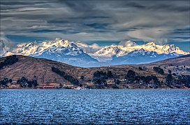 The Cordillera Real as seen from Lake Titicaca showing Chearoco and Chachacomani | |
| Highest point | |
| Elevation | 6,127 m (20,102 ft) |
| Prominence | 1,055 m (3,461 ft)[1] |
| Parent peak | Ancohuma |
| Isolation | 17.14 km (10.65 mi) |
| Coordinates | 15°57′00″S 68°24′56″W / 15.95000°S 68.41556°W[2] |
| Geography | |
 Chearoco | |
| Parent range | Andes, Cordillera Real |
| Climbing | |
| First ascent | 06/25/1928 - Erwin Hein (Austria), Alfred Horeschowski, Hugo Hoertnagel, and Hans Pfann (Germany)[3][4][5] |
The Aymara name of the mountain correlates with the names of the nearby area (Chiar Jokho) and the river Ch'iyar Juqhu (Chiar Jokho, Chiar Joko) which originates near the mountain.
First Ascent edit
Chearoko was first climbed by Erwin Hein (Austria), Alfred Horeschowski, Hugo Hoertnagel and Hans Pfann (Germany) 25 June 1928.[3][4]
Elevation edit
Other data from available digital elevation models: ASTER 6078 metres[16] and TanDEM-X 6106 metres.[17] The height of the nearest key col is 5049 meters, leading to a topographic prominence of 1055 meters.[18] Chearoko is considered a Mountain Massif according to the Dominance System [19] and its dominance is 17.28%. Its parent peak is Ancohuma and the Topographic isolation is 18.4 kilometers.[19]
See also edit
References edit
- ^ "Chearoko". Andes Specialists. Retrieved 2020-04-12.
- ^ kolossus-dewiki
- ^ a b Fantin. Le Ande. pp. 100–102.
- ^ a b Ostrowski. Mas Alto que los Condores.
- ^ Taken from Mountaineering in the Andes by Jill Neate, Bolivia, RGS-IBG Expedition Advisory Centre, 2nd edition, May 1994
- ^ Biggar, John (2020). The Andes: A Guide for Climbers and Skiers. Andes. p. 162. ISBN 9780953608768.
- ^ Murphy, Alan (2000). Bolivia Handbook: The Travel Guide. Footprint Handbooks. pp. 56, 155. ISBN 9781900949491.
- ^ Brain, Yossi; Thurman, Paula (1998-12-31). Bolivia: A Climbing Guide. The Mountaineers Books. p. 104. ISBN 9780898864953.
- ^ Nevado de Chiaraco (Approved) at GEOnet Names Server, United States National Geospatial-Intelligence Agency
- ^ a b Bolivian IGM map 1:50,000 Comunidad Amaguaya 5946-III (where the position of Ch'iyar Juqhu is possibly not labelled correctly)
- ^ Sarasúa, Vicente González (2000). Bolivia (in Spanish). Laertes. p. 18. ISBN 9788475844077.
- ^ Radio San Gabriel, "Instituto Radiofonico de Promoción Aymara" (IRPA) 1993, Republicado por Instituto de las Lenguas y Literaturas Andinas-Amazónicas (ILLLA-A) 2011, Transcripción del Vocabulario de la Lengua Aymara, P. Ludovico Bertonio 1612 (Spanish-Aymara-Aymara-Spanish dictionary)
- ^ The Instituto Nacional de Estadística de Bolivia (INE) lists it as the fifth-highest peak in Bolivia at 6,240 metres (20,472 ft), "Geografía de Bolivia: Principales Montañas Mayores a 6,000 m.s.n.m." (in Spanish). Instituto Nacional de Estadística de Bolivia. Archived from the original on 2014-02-11.; but Peakery lists it as the ninth-highest with an elevation of 6,104 metres (20,026 ft). "Nevado de Chiaraco". Peakery. Archived from the original on 2014-02-23. Retrieved 2014-02-05. The elevation listed here is that of Nevado de Chiaraco (Approved) at GEOnet Names Server, United States National Geospatial-Intelligence Agency.
- ^ "Guanay". INE, Bolivia. Archived from the original on October 6, 2014. Retrieved September 28, 2014. (unnamed, between Aman Pata and Silasani (Sialsani) and northwest of Patapatani)
- ^ "Catálogo GeoBolivia - GeoBolivia". geo.gob.bo. Retrieved 2020-04-30.
- ^ "ASTER GDEM Project". ssl.jspacesystems.or.jp. Retrieved 2020-04-14.
- ^ TanDEM-X, TerraSAR-X. "Copernicus Space Component Data Access". Archived from the original on 12 April 2020. Retrieved 12 April 2020.
- ^ "Chearoko". Andes Specialists. Retrieved 2020-04-12.
- ^ a b "Dominance - Page 2". www.8000ers.com. Retrieved 2020-04-12.