
KNOWPIA
WELCOME TO KNOWPIA

Bula, Indonesia 
Summary
Bula is a small town and kecamatan on the northeastern coast of the Indonesian island of Seram.[2] It is the capital of the East Seram Regency. According to the 2010 census, the district had a population of 24,037 people, but it has subsequently been split into three separate districts, with the reduced Bula district having a population of 15,812 at 2014.[3] In the vicinity are the Bula Fields, with notable oil reserves, which were established in 1919.[4][5] A number of people in the district speak the Masiwang language.[6]
Bula | |
|---|---|
Kecamatan and town | |
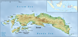 Bula Location in Seram Island | |
| Coordinates: 3°6′11″S 130°29′28″E / 3.10306°S 130.49111°E | |
| Country | Indonesia |
| Province | Maluku |
| Regency | East Seram |
| Population (2014)[1] | |
| • Total | 15,812 |
| Time zone | UTC+9 (WITA) |
References edit
- ^ Badan Pusat Statistik, Jakarta, 2018.
- ^ "Seram Island (map)". Indonesiatravelingguide.com. Archived from the original on 24 September 2015. Retrieved 8 June 2015.
- ^ Badan Pusat Statistik, Jakarta, 2018.
- ^ Association, Indonesian Petroleum (1994). Proceedings of the Annual Convention - Indonesian Petroleum Association. Indonesian Petroleum Association.
- ^ Proceedings of the ... Session: Technical reports. Committee for Co-ordination of Joint Prospecting for Mineral Resources in Asian Offshore Areas Project Office. 1994. p. 29. ISBN 978-974-89158-0-7.
- ^ Frawley, William J. (2003). International Encyclopedia of Linguistics. Oxford University Press. p. 299. ISBN 978-0-19-513977-8.