


Summary
Bari (Somali: Bari, Arabic: بري) is an administrative region (gobol) in northeastern Somalia.[3]⁹
Bari | |
|---|---|
 Overview of Bosaso. | |
 Flag  Coat of arms | |
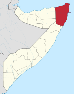 Location in africa. | |
| Coordinates: 11°17′47″N 48°00′00″E / 11.29639°N 48.00000°E | |
| Country | |
| Regional State | |
| Capital and largest | Bosaso |
| Government | |
| • Type | Region |
| • Governor | Abulsamad Gallan |
| Area | |
| • Total | 85,088 km2 (32,853 sq mi) |
| Population (2019 estimate[1]) | |
| • Total | 949,700 |
| • Density | 11/km2 (29/sq mi) |
| Time zone | UTC+3 (EAT) |
| Area code | 252 |
| HDI (2022) | 0.429[2] low · 4th of 18 |
Overview edit
It is bordered by Sool and Sanaag to the west, Nugal to the south, the Gulf of Aden to the north and the Guardafui Channel to the east. It is located on the tip of the Horn of Africa. Its name, Bari, literally means East in Somali.[4]
In terms of landmass, Bari is the largest province in the Federal Republic of Somalia. The highest point in this region is Mount Bahaya, the third tallest mountain in Somalia with an elevation of 2120 meters; other notable peaks include Karkaar and Cal Miskaad mountains.
Demographics edit
Most of the inhabitants of the Bari region belong to the Somali ethnic group including Warsangeli, Majeerteen,madhibaan Deshiishe, Kaskiqabe and other clans [5][6] According to the 2015 Population Estimation Survey, the population was 1,887,568 inhabitants. This figure combines both the rural and urban populations of Bari as well all IDPs (internally displaced persons).[7][8]
Administrative divisions edit

AfR=Af Ruugleey, AfU=Af Urur, Al=Alula, Ar=Armo, As=Ashira, Bari, Bc=Bacaad, BD=Balli Dhiddin, Be=Bereeda, BG=Bargal, BL=Bayla, Ba=Bacaad, BC=Booco, Bo=Bosaso, BS=Bandar Siyada, Bu=Bur Gaban, Da=Dalweyn, Da=Dangorayo, El=El Dahir, Ju=Juurile, ER=El Dhurre, Fo=Foar, Ga=Galgala, Hb= Habeeno, Ge=Geesaley, Gu=Gumbah, Ha=Hafun, Hb=Habo, Is=Iskushuban, Ka=Karin, Ko=Kob Dhexaad, La=Laas Dawaco, Ma=Majiyohan, Mu=Murcanyo, Qh=Qardho, Ql=Qandala, RB=Ras Binnah, RR=Rako Raaxo, Ta=Tager, Ti=Tisjiic, To=Tohen, Uf=Ufeyn, Uu=Uur Caleed, Wa=Waiye, XD=Xidda, Xi=Xiriiro, Yak=Yake, Yal=Yalho
In the official administrative divisions of Somalia, the Bari region consists of the following seven districts:[9]
The Bari region is the largest region of the 18 administrative regions of Somalia and it contains following districts.
- Bosaso District The capital and largest
- Qardho District
- Alula District
- Bandarbayla District
- Waiye
- Iskushuban District
- Qandala District
- Carmo District
- Ufayn District
In 1998, Bari became a part of Puntland, an autonomous region in northeastern Somalia. In the Transitional Constitution of the Puntland Regional Government of 2001, Puntland's territory is defined in terms of Somalia's official regions, Bari being one of them.[10]
In the years thereafter, Puntland changed its internal administrative division, and the Bari region was split in two: the southern half, roughly coinciding with the Qardho and Bandarbayla Districts, became the new region of Karkaar (also spelled as Karkar). It was subdivided into five new districts: Qardho, Bandarbayla, Waiye, Rako and Hafun Armo District. The northern half continued to be known as Bari and was split into seven districts: five of them keeping their original names (Bosaso, Iskushuban, Ufayn, Qandala and Alula), as well as three new ones: Carmo,Tisjiic and Bargal.[11]
Radio Galkacyo reported on 19 April 2011 that a new administration, called Raas Asayr, had been declared in parts of Bari Region. Farah Mahmud Yusuf was reported to have been elected as its president.[12] Later, Barre Fatah Said there were possibilities of starting negotiation between Puntland Government and the founders of Raas Assayr state. The leaders of this prospective polity retracted their claims a few months later in June 2012, indicating that they now supported Puntland and were satisfied with the Puntland authorities' new development projects in the region.[13]
On 8 April 2013, the Puntland government announced the creation of a new region named Gardafuul. Carved out of the Bari region, it consists of three districts and has its capital at Alula.[14]
References edit
- ^ "Somalia: Subdivision and cities". www.citypopulation.de. Retrieved 2024-02-14.
- ^ "Sub-national HDI - Area Database - Global Data Lab". hdi.globaldatalab.org. Retrieved 2018-09-13.
- ^ "Somalia". The World Factbook. Langley, Virginia: Central Intelligence Agency. Retrieved 6 December 2013.
- ^ Nakano, Aki'O. Basic Vocabulary in Standard Somali (I). Institute for the Study of Languages and Cultures of Asia and Africa, 1976.
- ^ Robert Buijtenhuijs, Piet Konings, Wim M. J. van Binsbergen, Gerti Hesseling, Trajectoires de libération en Afrique contemporaine: hommage à Robert Buijtenhuijs, (KARTHALA Editions: 2000), p.134.
- ^ Bader, Christian (1999). Le sang et le lait: brève histoire des clans somal. Maisonneuve & Larose. p. 236. ISBN 2-7068-1373-3.
- ^ "Puntland Issues Report of population Estimation of Its Residents". 27 May 2015.
- ^ Population Statistics of Somalia Archived March 15, 2016, at the Wayback Machine
- ^ "Bari Region" (PDF). Retrieved 30 December 2013.
- ^ See Article 3.1. (Territory, Borders and Its Inviolability and Sacredness) of the Transitional Constitution of the Puntland Regional Government at: http://www.puntlandgovt.com/puntland-constitution/ Archived 2018-04-13 at the Wayback Machine
- ^ List of Primary Schools in Puntland, see website of Puntland's Ministry of Education at: http://www.moepuntland.com/primary/
- ^ Radio Galkacyo website, Puntland, 19/4/2011, via ARB-PSC, April 1–31, 2011, p.18811A.
- ^ "No more Raas Assayr State as its founders retreated their claims and supported Puntland". Puntlandi. 11 June 2012. Archived from the original on February 12, 2014. Retrieved 21 June 2014.
- ^ "Garoowe: Gobal & Degmooyin cusub oo maalmahan si rasmi ah ugu soo biiraaya Gobalada & Degmooyinka Puntland". Archived from the original on 2015-06-13. Retrieved 2013-12-01.
External links edit
- Administrative map of Bari