


Summary
Apollinaris Mons[1] is an ancient shield volcano in the southern hemisphere of Mars. It is situated near the equator, south of Elysium Planitia and north of the impact crater Gusev (the landing site of the Mars rover Spirit). Elysium Planitia separates it from the volcanic province of Elysium to its northwest. The volcano's caldera is named Apollinaris Patera;[2] this name formerly applied to the whole edifice.
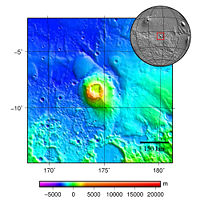 Topography map of Apollinaris Mons | |
| Coordinates | 9°18′S 174°24′E / 9.3°S 174.4°E[1] |
|---|---|
Apollinaris Mons is about 5 kilometres high with a base about 296 kilometres in diameter.[3] On the top of this volcano is a caldera about 80 km (50 miles) in diameter. The volcano is approximately 3 billion[4] to 3.5 billion years old.[5]
It was named in 1973 after a mountain spring near Rome in Italy.
A study using a global climate model found that the Medusae Fossae Formation could have been formed from ash from Apollinaris Mons, Arsia Mons, and possibly Pavonis Mons.[6]
Paleomagnetic field studies edit
Apollinaris Patera parallels many of the volcanic terrains on Mars, including most of the Elysium and Tharsis Rises, in that they are demagnetized terrains that conspicuously predate the shutdown of the Martian dynamo. The mechanism of its deactivation has been compared to that of Hadriacus Mons. Researchers observing this noted that the deposition of lavas atop an older, more magnetized terrain might have led to the region's demagnetization. Its existence thus does not challenge hypotheses about the timing of the dynamo shutdown.[7]
Gallery edit
-
 False-color Mars Global Surveyor image of Apollinaris Mons. White clouds can be seen hovering above the volcano.

Interactive Mars map edit

See also edit
References edit
- ^ a b "Apollinaris Mons". Gazetteer of Planetary Nomenclature. USGS Astrogeology Science Center. Retrieved 2012-06-30.
- ^ "Apollinaris Patera". Gazetteer of Planetary Nomenclature. USGS Astrogeology Science Center. Retrieved 2012-06-30.
- ^ "Google Mars". www.google.com. Retrieved 12 June 2019.
- ^ "APOD: May 13, 1999 - Mars Volcano Apollinaris Patera". apod.nasa.gov. Retrieved 12 June 2019.
- ^ "23. Apollinaris Patera Elysium Planitia, Mars". www.lpi.usra.edu. Retrieved 12 June 2019.
- ^ Kerber L., et al. 2012. The disporsal of pyroclasts from ancient explosive volcanoes on Mars: Implications for the friable layered deposits. Icarus. 219:358-381.
- ^ Morschhauser, AM; Vervelidou, F; Thomas, P; Grott, M; Lesur, V; Gilder, SA (2018). "Mars' Crustal Magnetic Field". Magnetic Fields in the Solar System. Dordrecht: Springer. ISBN 9783319642918.