
KNOWPIA
WELCOME TO KNOWPIA

140th meridian east 
Summary
The meridian 140° east of Greenwich is a line of longitude that extends from the North Pole across the Arctic Ocean, Asia, the Pacific Ocean, Australasia, the Indian Ocean, the Southern Ocean, and Antarctica to the South Pole.

140°
class=notpageimage|
140th meridian eastThe 140th meridian east forms a great circle with the 40th meridian west.
From Pole to Pole edit
Starting at the North Pole and heading south to the South Pole, the 140th meridian east passes through:
Co-ordinates Country, territory or sea Notes 90°0′N 140°0′E / 90.000°N 140.000°E Arctic Ocean 75°57′N 140°0′E / 75.950°N 140.000°E  Russia
Sakha Republic — Kotelny Island, New Siberian Islands 74°54′N 140°0′E / 74.900°N 140.000°E Laptev Sea 73°26′N 140°0′E / 73.433°N 140.000°E Russia
Sakha Republic — Great Lyakhovsky Island, New Siberian Islands 73°20′N 140°0′E / 73.333°N 140.000°E Laptev Sea 72°29′N 140°0′E / 72.483°N 140.000°E Russia
Sakha Republic
Khabarovsk Krai — from 61°58′N 140°0′E / 61.967°N 140.000°E57°42′N 140°0′E / 57.700°N 140.000°E Sea of Okhotsk 54°6′N 140°0′E / 54.100°N 140.000°E Russia
Khabarovsk Krai 48°20′N 140°0′E / 48.333°N 140.000°E Sea of Japan 42°41′N 140°0′E / 42.683°N 140.000°E  Japan
Japan
Island of Hokkaidō
— Hokkaidō Prefecture42°7′N 140°0′E / 42.117°N 140.000°E Sea of Japan 41°38′N 140°0′E / 41.633°N 140.000°E Japan
Island of Hokkaidō
— Hokkaidō Prefecture41°32′N 140°0′E / 41.533°N 140.000°E Sea of Japan 40°44′N 140°0′E / 40.733°N 140.000°E Japan
Island of Honshū
— Aomori Prefecture
— Akita Prefecture — from 40°25′N 140°0′E / 40.417°N 140.000°E39°51′N 140°0′E / 39.850°N 140.000°E Sea of Japan 39°20′N 140°0′E / 39.333°N 140.000°E Japan
Island of Honshū
— Akita Prefecture
— Yamagata Prefecture — from 39°6′N 140°0′E / 39.100°N 140.000°E
— Fukushima Prefecture — from 37°45′N 140°0′E / 37.750°N 140.000°E
— Tochigi Prefecture — from 37°8′N 140°0′E / 37.133°N 140.000°E
— Ibaraki Prefecture — from 36°22′N 140°0′E / 36.367°N 140.000°E
— Chiba Prefecture — from 35°54′N 140°0′E / 35.900°N 140.000°E35°39′N 140°0′E / 35.650°N 140.000°E Tokyo Bay 35°28′N 140°0′E / 35.467°N 140.000°E Japan
Island of Honshū
— Chiba Prefecture (Bōsō Peninsula)35°1′N 140°0′E / 35.017°N 140.000°E Pacific Ocean Passing just east of the island of Hachijōjima, Tokyo Prefecture, Japan (at 33°5′N 139°52′E / 33.083°N 139.867°E)
Passing just east of the island of Aogashima, Tokyo Prefecture, Japan (at 32°27′N 139°47′E / 32.450°N 139.783°E)
Passing through the Bayonnaise Rocks, Tokyo Prefecture, Japan (at 31°55′N 139°0′E / 31.917°N 139.000°E)
Passing just west of Smith Island, Tokyo Prefecture, Japan (at 31°26′N 140°2′E / 31.433°N 140.033°E)
Passing just west of Tori Shima, Tokyo Prefecture, Japan (at 30°29′N 140°18′E / 30.483°N 140.300°E)
Passing just east of Ulithi Atoll, Federated States of Micronesia (at 9°55′N 139°34′E / 9.917°N 139.567°E)
2°21′S 140°0′E / 2.350°S 140.000°E  Indonesia
 Papua New Guinea
Forms the northern half of the Indonesia–Papua New Guinea border on the island of New Guinea 8°14′S 140°0′E / 8.233°S 140.000°E Arafura Sea 11°22′S 140°0′E / 11.367°S 140.000°E Gulf of Carpentaria 17°43′S 140°0′E / 17.717°S 140.000°E  Australia
Queensland
South Australia — from 26°0′S 140°0′E / 26.000°S 140.000°E37°29′S 140°0′E / 37.483°S 140.000°E Indian Ocean Australian authorities consider this to be part of the Southern Ocean[1][2] 60°0′S 140°0′E / 60.000°S 140.000°E Southern Ocean 66°42′S 140°0′E / 66.700°S 140.000°E Antarctica Adélie Land, claimed by  France
Japan edit
Gallery edit
-
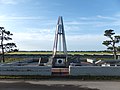 40°N and 140°E Crossing Point in Ogata, Akita

See also edit
References edit