


Summary
49°00′08″N 122°29′33″W / 49.002312°N 122.492623°W
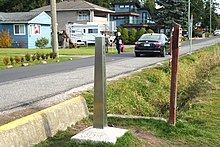 0 Avenue by the border, as seen from the United States | |
| Length | 29.0 km (18.0 mi)[1] |
|---|---|
| Location | Surrey, Langley (Township), Abbotsford |
| West end | Peace Park Drive in Surrey |
| East end | Townline Road in Abbotsford |
0 Avenue (Zero Avenue) is a road in the Lower Mainland, British Columbia, running beside the Canada–United States border from Surrey to Abbotsford.[2] The road runs parallel to the physical border between the two countries.[3]
The road begins near the Peace Arch Border Crossing, and continues eastward for 28.9 kilometres (18.0 mi), with gaps around the Pacific Highway and Lynden–Aldergrove Border Crossings. Boundary Road on the US side runs for 1.5 miles along 0 Avenue and again one mile to the west, with many cameras watching the border, before the U.S. road ends at the Lynden–Aldergrove Border Crossing. 0 Avenue continues west along the northern border of Peace Arch Historical State Park to Peace Arch Crossing. Small pedestrian bridges cross a trench on the border. At the eastern end of 0 Avenue, the road turns north.[2]
The road is used by smugglers, even though the border controls have tightened up since the September 11 attacks.[4] The first known drug tunnel along the Canada–United States border was found east of the Lynden–Aldergrove crossing in 2005.[2] Some asylum seekers have also tried to move to Canada from the U.S. via 0 Avenue.[5]
During the COVID-19 pandemic, restrictions on cross-border travel made 0 Avenue a meeting place for several cross-border couples.[6] Once restrictions were lifted, some of these couples married at Peace Arch Park, a transnational park between Blaine and Surrey.[6][7]
Major intersections edit
| Regional District | Location | km[1] | mi | Destinations | Notes | ||
|---|---|---|---|---|---|---|---|
| Metro Vancouver | Surrey | 0.0 | 0.0 | Peace Park Drive | Roadway continues north as Peace Park Drive; connects to Hwy 99 north | ||
| Gap in route | |||||||
| 1.4 | 0.87 | Resumes as 1 Avenue | |||||
| 1.7 | 1.1 | 177A Street | Roadway turns south and becomes 177A Street | ||||
| 1.9 | 1.2 | 0 Avenue | Roadway turns east and becomes 0 Avenue | ||||
| Langley (Township) | 19.3 | 12.0 | 264 Street | Eastbound access to Hwy 13 | |||
| 19.8 | 12.3 | No access from the west (dead end); no westbound to southbound turns | |||||
| Fraser Valley | Abbotsford | 29.0 | 18.0 | Townline Road | Roadway continues north as Townline Road | ||
1.000 mi = 1.609 km; 1.000 km = 0.621 mi
| |||||||
References edit
- ^ a b Google (October 7, 2021). "0 Avenue" (Map). Google Maps. Google. Retrieved October 7, 2021.
- ^ a b c "Chapter 6: Washington State". United Divide: A Linear Portrait of the USA/Canada Border. The Center for Land Use Interpretation. Winter 2015.
- ^ "Exploring the border at Blaine: U.S.-Canada crossing offers its own tourist experience". Seattle Pi. February 25, 2009. Retrieved February 6, 2021.
- ^ MacDonald, Jake (2010). "Smuggling on the Canada-U.S. border". Canadian Geographic. The Royal Canadian Geographical Society. Archived from the original on 10 July 2010. Retrieved 8 June 2016.
- ^ "Avenue 0: How U.S. asylum seekers are finding their way to British Columbia". CBC News. 2017-03-28. Retrieved 2021-02-06.
- ^ a b Page, Sydney (June 16, 2020). "There's a loophole along the closed U.S.-Canada border. Couples are getting married there". The Washington Post. Archived from the original on March 17, 2022. Retrieved March 17, 2022.
- ^ "Peace Arch Historical State Park | Washington State Parks and Recreation Commission". www.parks.wa.gov. Archived from the original on 2022-03-17. Retrieved 2022-03-17.
External links edit
 Media related to 0 Avenue at Wikimedia Commons